Ezibomvini: Water Walk – 2nd October 2024
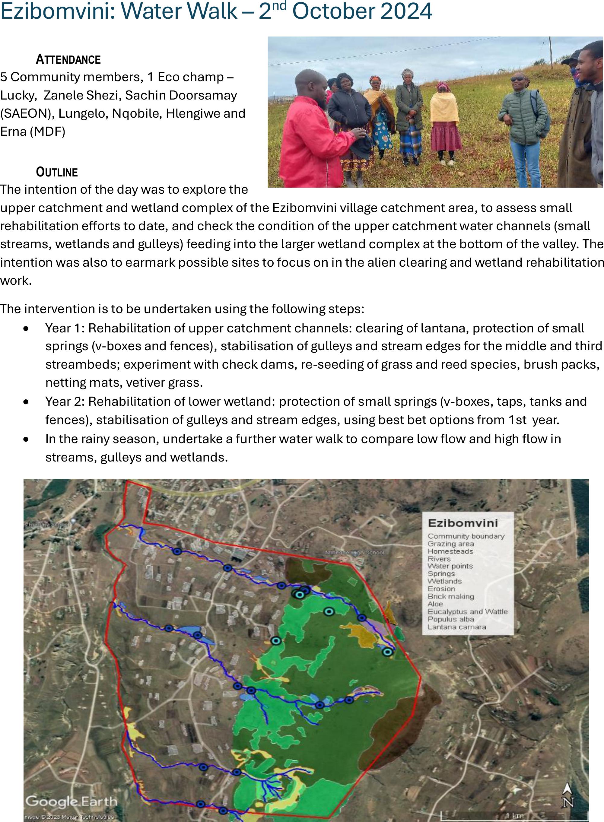
ATTENDANCE
5 Community members, 1 Eco champ –
Lucky, Zanele Shezi, Sachin Doorsamay
(SAEON), Lungelo, Nqobile, Hlengiwe and
Erna (MDF)
OUTLINE
The intention of the day was to explore the
upper catchment and wetland complex of the Ezibomvini village catchment area, to assess small
rehabilitation eorts to date, and check the condition of the upper catchment water channels (small
streams, wetlands and gulleys) feeding into the larger wetland complex at the bottom of the valley. The
intention was also to earmark possible sites to focus on in the alien clearing and wetland rehabilitation
work.
The intervention is to be undertaken using the following steps:
•Year 1: Rehabilitation of upper catchment channels: clearing of lantana, protection of small
springs (v-boxes and fences), stabilisation of gulleys and stream edges for the middle and third
streambeds; experiment with check dams, re-seeding of grass and reed species, brush packs,
netting mats, vetiver grass.
•Year 2: Rehabilitation of lower wetland: protection of small springs (v-boxes, taps, tanks and
fences), stabilisation of gulleys and stream edges, using best bet options from 1st year.
•In the rainy season, undertake a further water walk to compare low ow and high ow in
streams, gulleys and wetlands.
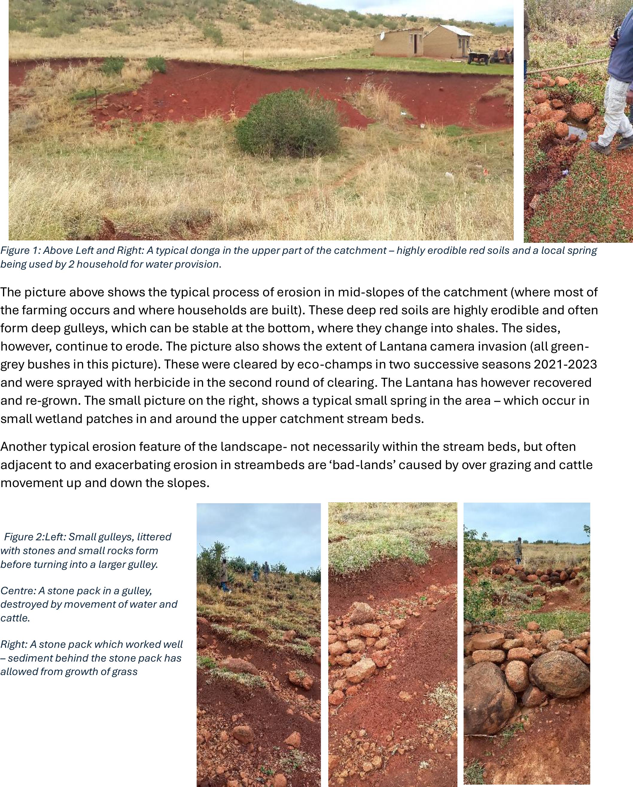
Figure 1: Above Left and Right: A typical donga in the upper part of the catchment – highly erodible red soils and a local spring
being used by 2 household for water provision.
The picture above shows the typical process of erosion in mid-slopes of the catchment (where most of
the farming occurs and where households are built). These deep red soils arehighly erodible and often
form deep gulleys, which can be stable at the bottom, where they change into shales. The sides,
however, continue to erode. The picture also shows the extent of Lantana camera invasion (all green-
grey bushes in this picture). These were cleared by eco-champs in two successive seasons 2021-2023
and were sprayed with herbicide in the second round of clearing. The Lantana has however recovered
and re-grown. The small picture on the right, shows a typical small spring in the area – which occur in
small wetland patches in and around the upper catchment stream beds.
Another typical erosion feature of the landscape- not necessarily within the stream beds, but often
adjacent to and exacerbating erosion in streambeds are ‘bad-lands’ caused by over grazing and cattle
movement up and down the slopes.
Figure 2:Left: Small gulleys, littered
with stones and small rocks form
before turning into a larger gulley.
Centre: A stone pack in a gulley,
destroyed by movement of water and
cattle.
Right: A stone pack which worked well
– sediment behind the stone pack has
allowed from growth of grass
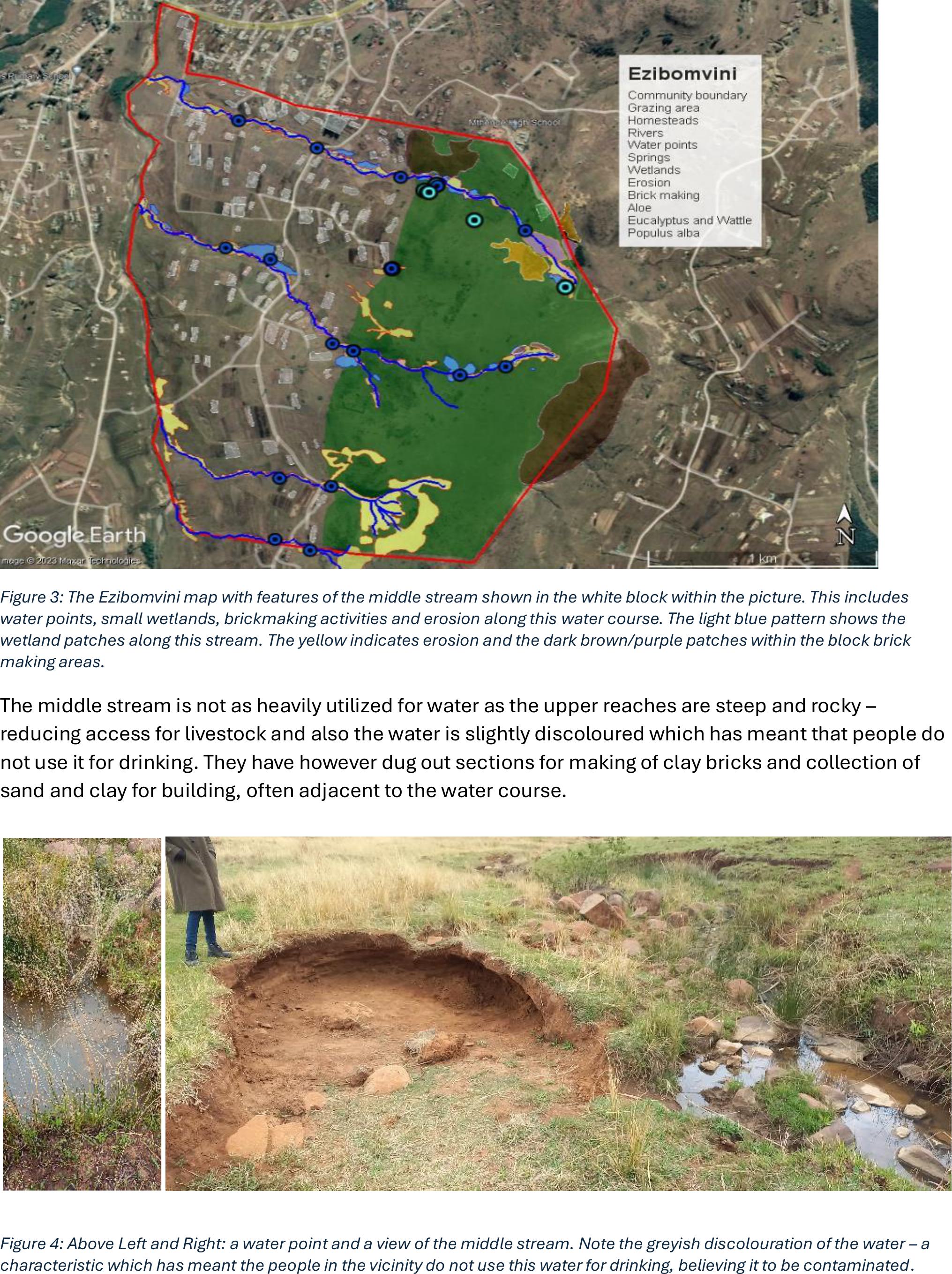
Figure 3: The Ezibomvini map with features of the middle stream shown in the white block within the picture. This includes
water points, small wetlands, brickmaking activities and erosion along this water course. The light blue pattern shows the
wetland patches along this stream. The yellow indicates erosion and the dark brown/purple patches within the block brick
making areas.
The middle stream is not as heavily utilized for water as the upper reaches are steep and rocky –
reducing access for livestock and also the water is slightly discoloured which has meant that people do
not use it for drinking. They have however dug out sections for making of clay bricks and collection of
sand and clay for building, often adjacent to the water course.
Figure 4: Above Left and Right: a water point and a view of the middle stream. Note the greyish discolouration of the water – a
characteristic which has meant the people in the vicinity do not use this water for drinking, believing it to be contaminated.
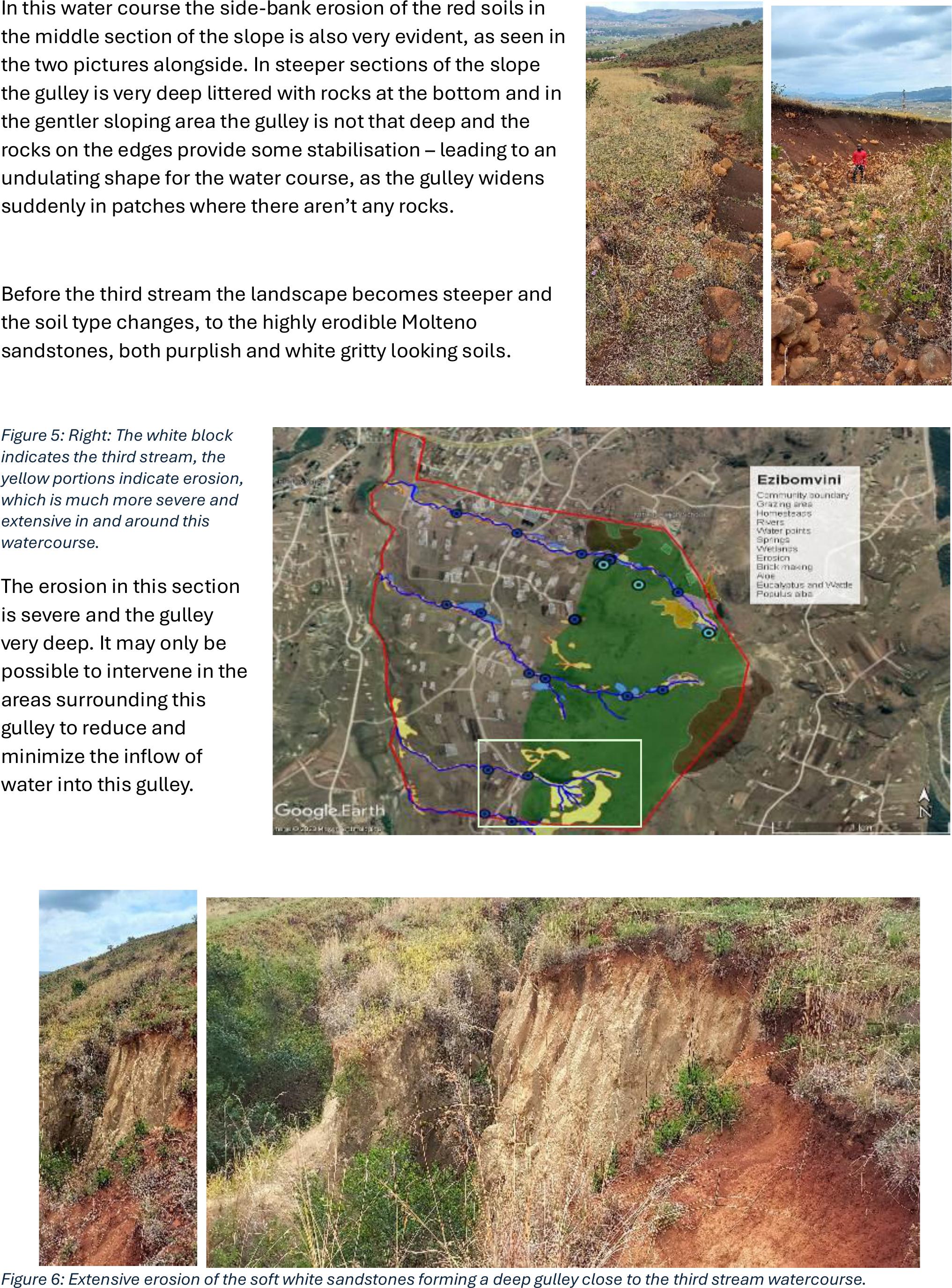
In this water course the side-bank erosion of the red soils in
the middle section of the slope is also very evident, as seen in
the two pictures alongside. In steeper sections of the slope
the gulley is very deep littered with rocks at the bottom and in
the gentler sloping area the gulley is not that deep and the
rocks on the edges provide some stabilisation– leading to an
undulating shape for the water course, as the gulley widens
suddenly in patches where there aren’t any rocks.
Before the third stream the landscape becomes steeper and
the soil type changes, to the highly erodible Molteno
sandstones, both purplish and white gritty looking soils.
Figure 5: Right: The white block
indicates the third stream, the
yellow portions indicate erosion,
which is much more severe and
extensive in and around this
watercourse.
The erosion in this section
is severe and the gulley
very deep. It may only be
possible to intervene in the
areas surrounding this
gulley to reduce and
minimize the inow of
water into this gulley.
Figure 6: Extensive erosion of the soft white sandstones forming a deep gulley close to the third stream watercourse.
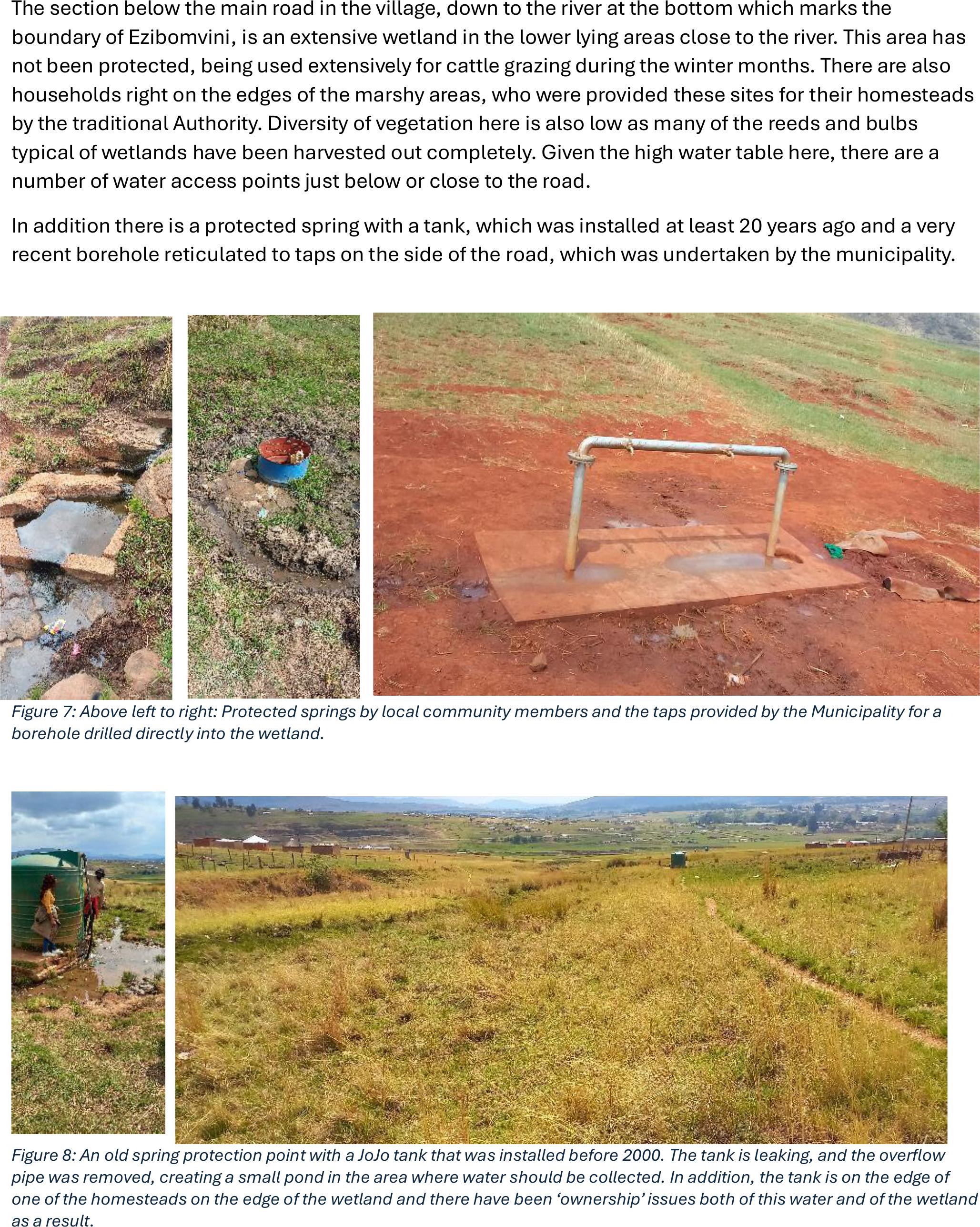
The section below the main road in the village, down to the river at the bottom which marks the
boundary of Ezibomvini, is an extensive wetland in the lower lying areas close to the river. This area has
not been protected, being used extensively for cattle grazing during the winter months. There are also
households right on the edges of the marshy areas, who were provided these sites for their homesteads
by the traditional Authority. Diversity of vegetationhere is also low as many of the reeds and bulbs
typical of wetlands have been harvested out completely. Given the high water table here, there are a
number of water access points just below or close to the road.
In addition there is a protected spring with a tank, which was installed at least 20 years ago and a very
recent borehole reticulated to taps on the side of the road, which was undertaken by the municipality.
Figure 7: Above left to right: Protected springs by local community members and the taps provided by the Municipality for a
borehole drilled directly into the wetland.
Figure 8: An old spring protection point with a JoJo tank that was installed before 2000. The tank is leaking, and the overow
pipe was removed, creating a small pond in the area where water should be collected. In addition, the tank is on the edge of
one of the homesteads on the edge of the wetland and there have been ‘ownership’ issues both of this water and of the wetland
as a result.
RECOMMENDATIONS EZIBOMVINI
•Start with the upper water courses in the 1st 7 months of the project and move on to
rehabilitation work on the lower plain after May 2025.
•For water courses prioritize the following activities:
oClearing of lantana in and around the streambeds
▪Continue with check dams and stonelines for small gulleys and cattle paths
that feed into these water courses and do diversion ditches (horse shoe shaped)
above head cuts (mainly for middle and 3rd streams).
oChoose some high lying wetlands patches linked to the water courses (middle and 3rd
streams) and experiment with appropriate rehabilitation eorts here. These can include:
▪Checkdams, brush packs on side wide walls,
▪netting mats on side walls
▪Planting grasses in sediment patches (mainly junciformis and tall fescue)
▪Find sources of vetiver and plant along edges where erosion is active.
oPrioritize 3-4 small springs that are in use: protect by fencing, setting up JoJo tank and
cattle drinking points outside fenced areas and do a small v-box if called for at each
spring.