Final Report:
STRENGTHENING THE UPPER UTHUKELA WATER PARTNERSHIP ZA06370.A, ID852
1 June 2022 – 30 April 2024
STRENGTHENING THE PARTNERSHIP FOR THE NORTHERN DRAKENSBERG STRATEGIC
WATER SOURCE AREA, WITH A FOCUS ON THE UPPER UTHUKELA CATCHMENT
Prepared for:
Contact: Samir Randera-Rees
srandera@wwf.org.za
Prepared by:
Contact person: Brigid Letty
bletty@inr.org.za
31 March 2024
Table of contents
1Introduction ........................................................................................................................1
1.1Background ..................................................................................................................1
1.2Outcomes and scope ...................................................................................................1
1.3Project outcomes ........................................................................................................1
2Project achievements .........................................................................................................2
2.1Description of process towards achieving objectives .................................................2
2.2Establishment of the water source forum partnership and housing of the secretariat
3
2.2.1Online core team meeting ...................................................................................3
2.2.2Physical meeting of the upper uThukela Partnership in May 2023 ..................12
2.2.3Online NDC core team meeting on 23 August 2023 ..........................................16
2.2.4Field trip to Stulwane for NDC members ...........................................................22
2.2.5Online NDC Core team meeting in March 2024 ................................................27
2.2.6Meeting in Bergville in March 2024 ...................................................................36
2.3Situation assessment, stakeholder mapping and analysis ........................................38
2.3.1Situation assessment .........................................................................................38
2.3.2Stakeholder mapping and analysis ....................................................................38
2.4Strategy development and creation of CoPs ............................................................42
2.4.1Strategy development process ..........................................................................42
2.4.2Draft NDC strategy .............................................................................................43
2.4.3Progress towards establishing communities of practice ...................................49
2.5Three hectares of rangeland under restoration and management ..........................51
2.5.1Project sites ........................................................................................................51

2.5.2Restoration work at Stulwane ...........................................................................53
2.5.3Restoration work at AmaSwazi ..........................................................................59
2.5.4Monitoring activities ..........................................................................................67
2.6Other activities ..........................................................................................................81
2.6.1PepsiCo site visit ................................................................................................81
3Lessons learnt and recommendations .............................................................................82
4Conclusion ........................................................................................................................83
1
1INTRODUCTION
1.1Background
The Institute of Natural Resources NPC (INR) was appointed by WWF to work with Mahlathini
Development Foundation and the Centre for Water Resources Research (CWRR) at University
of KwaZulu-Natal, to establish apartnership in the Northern Drakensberg Strategic Water
Source Area (SWSA), with a focus on the Upper uThukela Catchment. This project built on the
outcomes of the Living Catchments Project, an initiative of the South African National
Biodiversity Institute (SANBI). The project team acknowledges WWF-SA for supporting this
initiative and acknowledges PepsiCo as the primary funder.
1.2Outcomes and scope
The anticipated outcomes and scope of the project were:
1.A functional water source forum with a coherent vision, strategy and implementation
process.
2.Involvement of a range of key role players in the development of coherent policies,
strategies, targets, programmes, governance structures and monitoring and
evaluation (M&E) for improved water stewardship.
3.Communities of practice (CoPs) focusedon different thematic areas within the process
(e.g. governance, stewardship implementation and funding, built and ecological water
infrastructure, climate change adaptation and mitigation, M&E.
4.Targeted improvement in a set of chosen stewardship indicators.
5.Rangeland restoration and management to demonstrate benefits in terms of
increasing infiltration and reducing run-off.
6.Development of frameworks for blended finance and long-term sustainability.
1.3Project outcomes
The agreed outcomes of the project were:
1.Establishment of the water source forum partnership and housing of the secretariat.
2.Baseline information gathering and communication (situation assessment),
stakeholder mapping and analysis.
2
3.Strategy development and creation of CoPs (annualwork programmes, meetings,
reports, communications).
4.Three hectares of rangeland under restoration and management.
5.Development of a consistent M&E system.
2PROJECT ACHIEVEMENTS
2.1Description of process towards achieving objectives
A key element of the process towards achieving the objectives was stakeholder engagement
and formation of partnerships.
The process towards achieving the restoration-related objectives relied on partnerships with
WILDTRUST at AmaSwazi and Mahlathini at Stulwane. Furthermore, partnerships with teams
working in the uMKhomazi Catchment allowed for sharing of skills and expertise related to
the installation of brushpacks and planting of vetiver along the brushpacks to increase their
lifespan.
The establishment of the water source forum partnership together with the development of
a strategy and an M&E system all required stakeholder engagement. A core team of active
stakeholders were important for making progress with the deliverables. They provided
guidance to the convening team between face-to-face meetings with the broader group of
stakeholders.
Even the situational assessment drew on the knowledge of stakeholders. The draft document
was shared with members of the core team and this substantially broadened the content of
the document. The intention is to house the situational assessment as well as the various
papers, articles and reports on the partnership’s website in a repository tosupport knowledge
access and sharing.
Overall, the project made substantial progress in establishing a partnership, though the
process of developing a more detailed strategy, especially detailing the objectives of the
different CoPs, will need to be taken forward by the core team building on a foundation
provided by this project. In terms of the restorationwork, it proved challenging to meet the
3 ha target and a decision was taken with the WWF project manager to rather stabilize the
3
brushpacks that had been installed with lines of vetiver to extend their lifespan rather than
expanding the area under restoration.
2.2Establishment of the water source forum partnership and housing of the secretariat
This process of establishing the partnership was initiated through the Living Catchments
Project (LCP) of the South African National Biodiversity Institute (SANBI), and has been
continued through an initiative championed by WWF. A coordinating team comprising the
Institute of Natural Resources NPC (INR), Mahlathini Development Foundation (MDF) and the
Centre for Water Resources Research (CWRR) at University of KwaZulu-Natal, has led the
process of operationalising and sustaining the partnership.
The objectives and outcomes of each of the meetings or workshops are summarised below
to track the progress towards establishing the partnership.
2.2.1Online core team meeting
An online meeting for stakeholders identified by the convening team took place on 11 April
2023 from 10h00 – 13h00. The organisations represented were Centre for Water Resources
Research (CWRR) at University of KwaZulu-Natal (UKZN), INR, Northern Drakensberg Nature
Reserve, Peaks Foundation, AmaZizi Action Group, Mahlathini Development Foundation
(MDF), South African EarthObservation Network (SAEON), WWF, Expanded Freshwater and
Terrestrial Environmental Observation Network (EFTEON), Maluti Drakensberg Transfrontier
Park, MDTP), WildTrust and Endangered Wildlife Trust (EWT). Representatives from
Department of Water and Sanitation (DWS) and the Department of Forestry, Fisheries and
the Environment (DFFE) sent apologies.
Recap of the role of WWF in partnership building
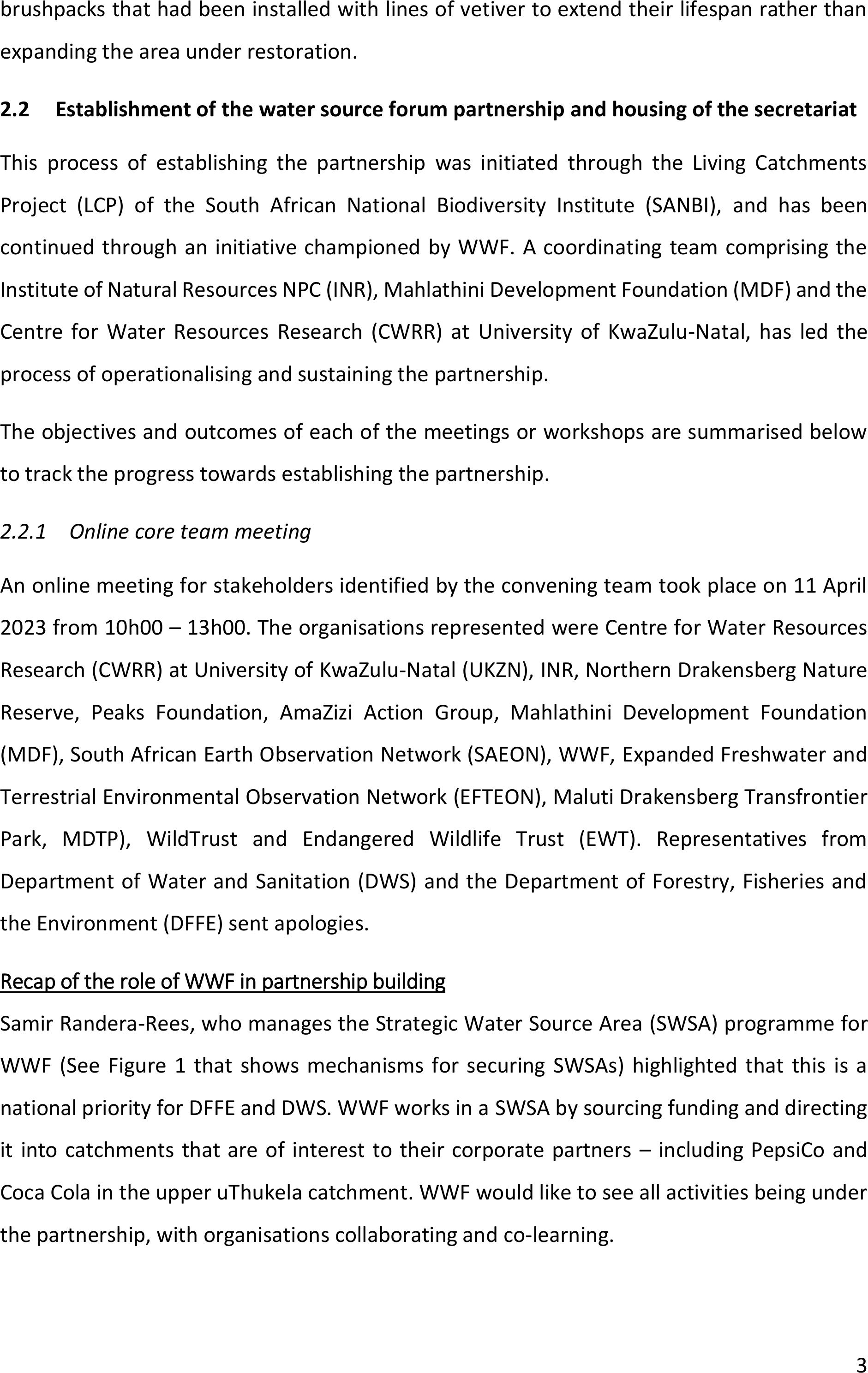
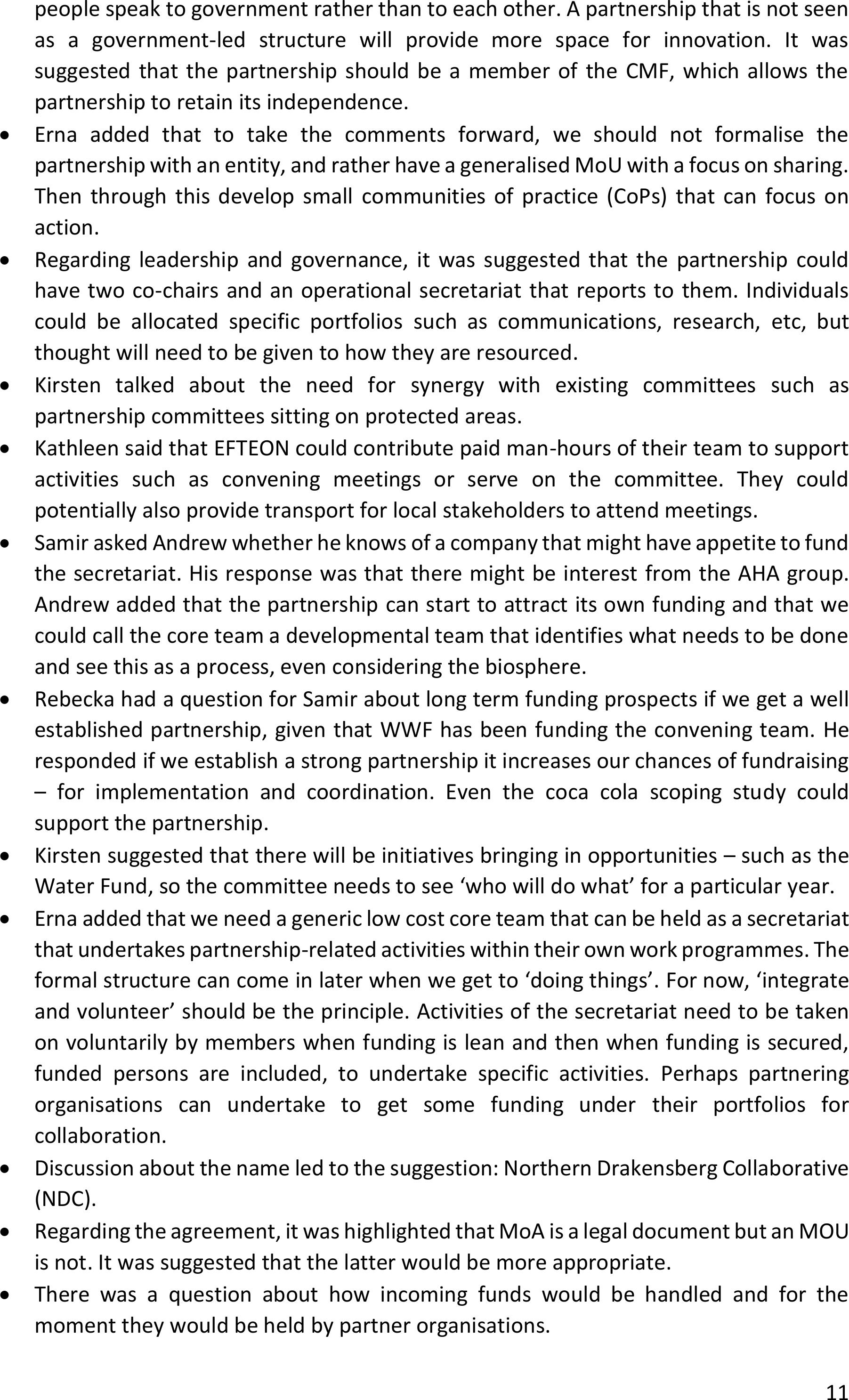
Samir Randera-Rees, who manages the Strategic Water Source Area (SWSA) programmefor
WWF (See Figure 1 that shows mechanisms for securing SWSAs) highlighted that this is a
national priority for DFFE and DWS. WWF works in a SWSA by sourcing funding and directing
it into catchments that are of interestto their corporate partners –including PepsiCo and
Coca Cola in the upper uThukela catchment. WWF would like to see all activities being under
the partnership, with organisations collaborating and co-learning.
4
Figure 1: Mechanisms for securing water source areas.
Update on previous stakeholder engagements
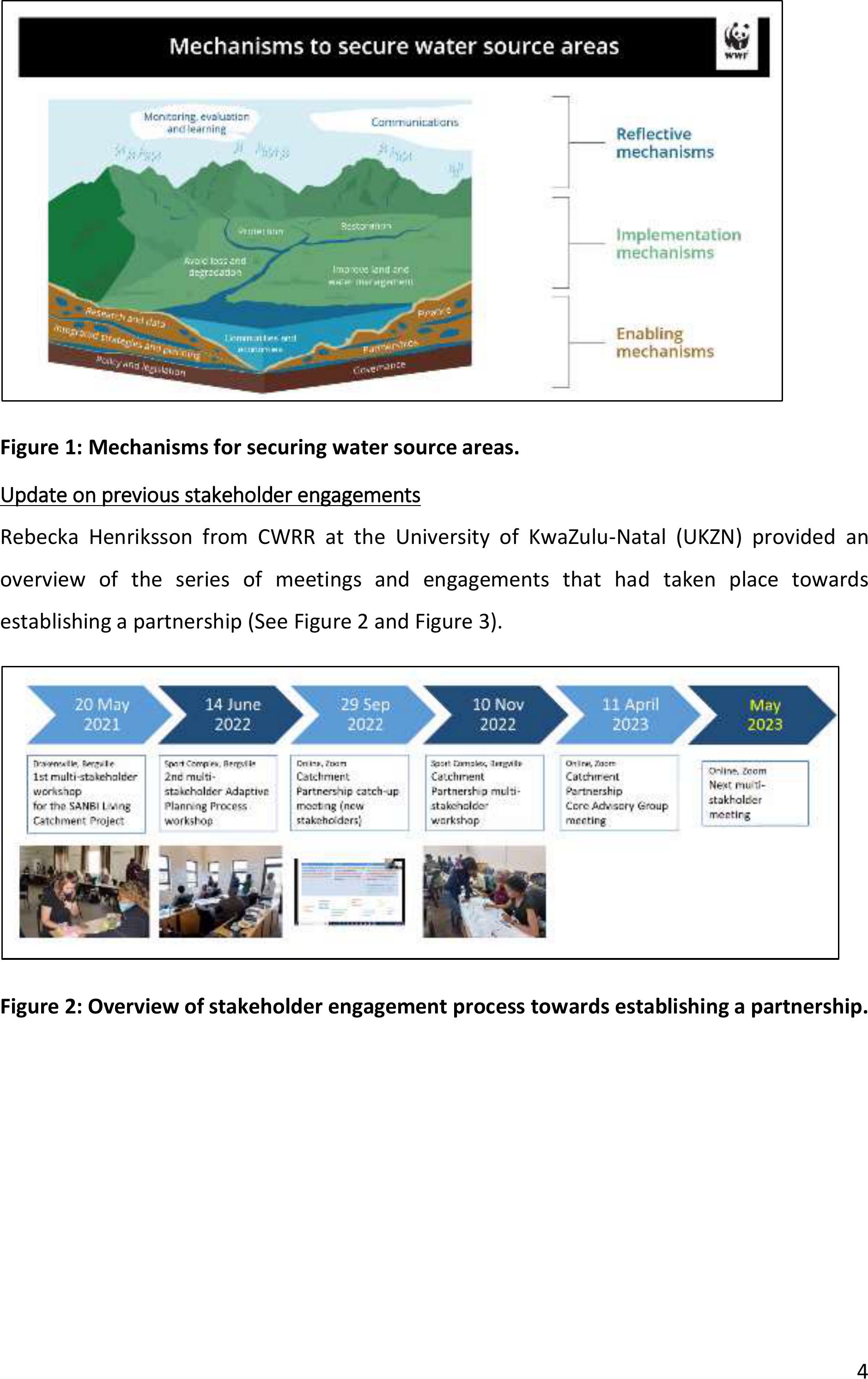
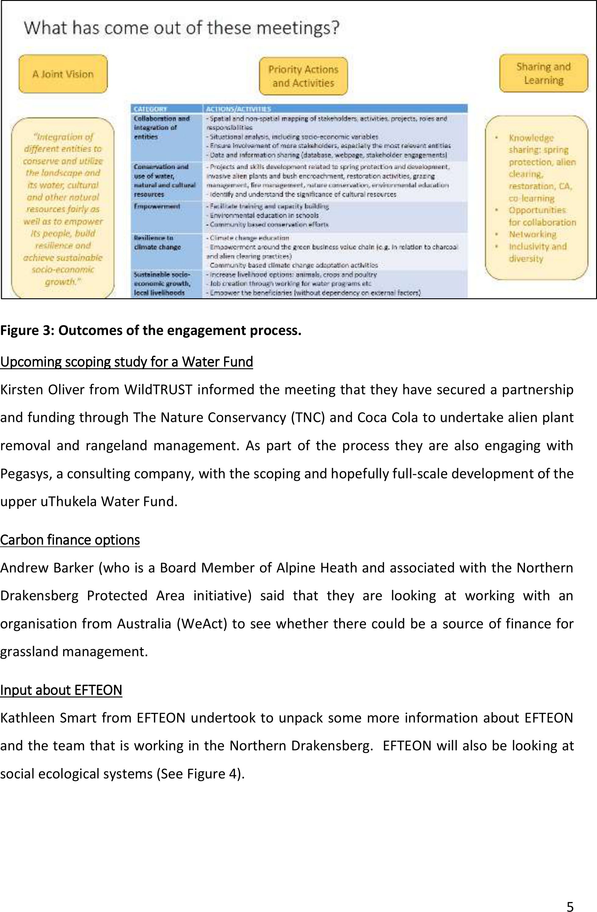
Rebecka Henriksson from CWRR at the University ofKwaZulu-Natal (UKZN) provided an
overview of the series of meetings and engagements that had taken place towards
establishing a partnership (See Figure 2 and Figure 3).
Figure 2: Overview of stakeholder engagement process towards establishing a partnership.
5
Figure 3: Outcomes of the engagement process.
Upcoming scoping study for a Water Fund
Kirsten Oliver from WildTRUST informed the meeting that they have secured a partnership
and funding through The Nature Conservancy (TNC) and Coca Cola to undertake alien plant
removal and rangeland management. As part of the process they are also engaging with
Pegasys, a consulting company, with the scoping and hopefully full-scale development of the
upper uThukela Water Fund.
Carbon finance options
Andrew Barker (who is a Board Member of Alpine Heath and associated with the Northern
Drakensberg Protected Area initiative) said that they are looking at working with an
organisation from Australia (WeAct) to see whether there could be a source of finance for
grassland management.
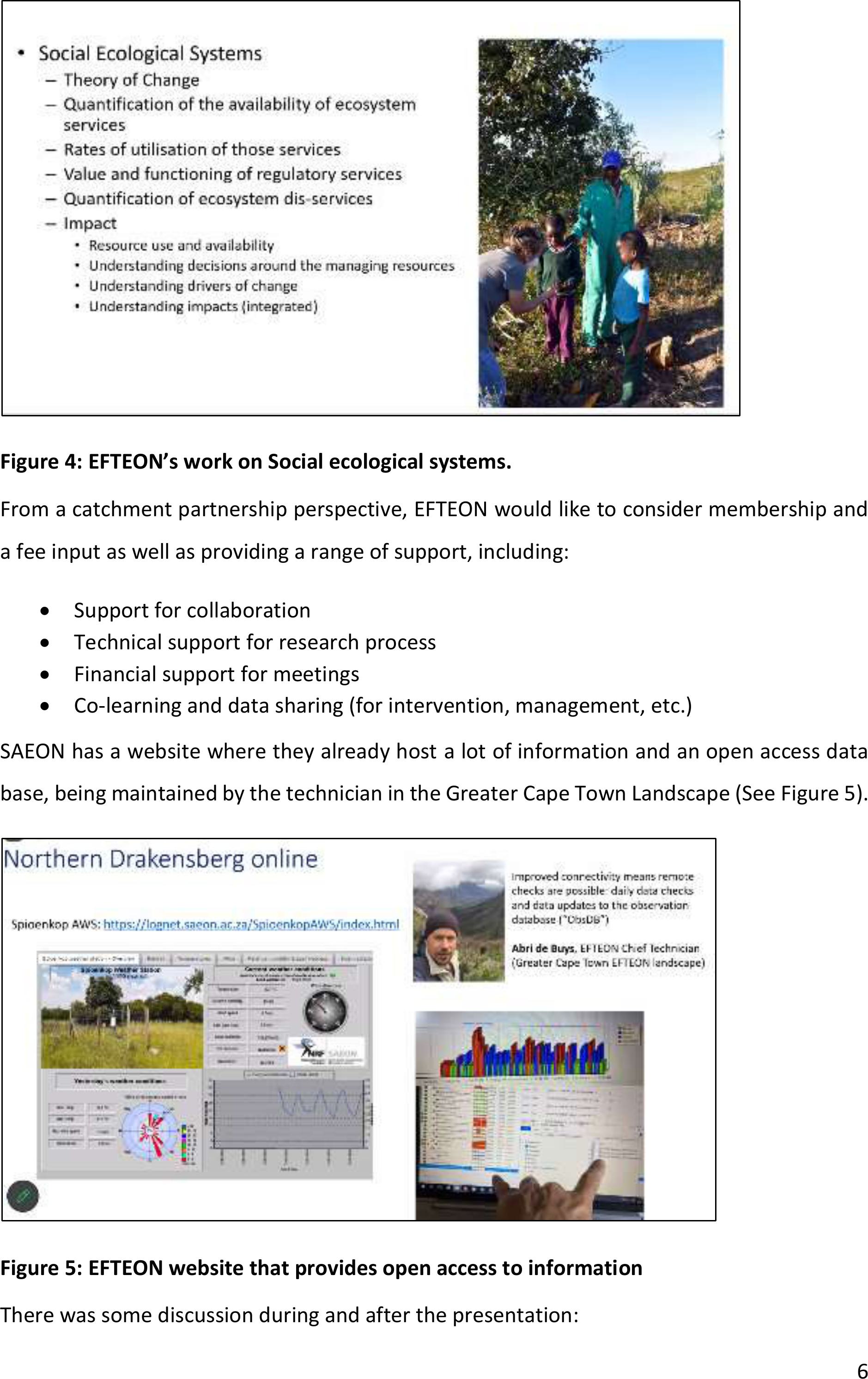
Input about EFTEON
Kathleen Smart from EFTEON undertook to unpack some more information about EFTEON
and the team that is working in the Northern Drakensberg. EFTEON will also be lookingat
social ecological systems (See Figure 4).
6
Figure 4: EFTEON’s work on Social ecological systems.
From a catchment partnership perspective, EFTEON would like to consider membership and
a fee input as well as providing a range of support, including:
•Support for collaboration
•Technical support for research process
•Financial support for meetings
•Co-learning and data sharing (for intervention, management, etc.)
SAEON has a website where they already host a lot of information and an open access data
base, being maintained by the technician in the Greater Cape Town Landscape (See Figure 5).
Figure 5: EFTEON website that provides open access to information
There was some discussion during and after the presentation:
7
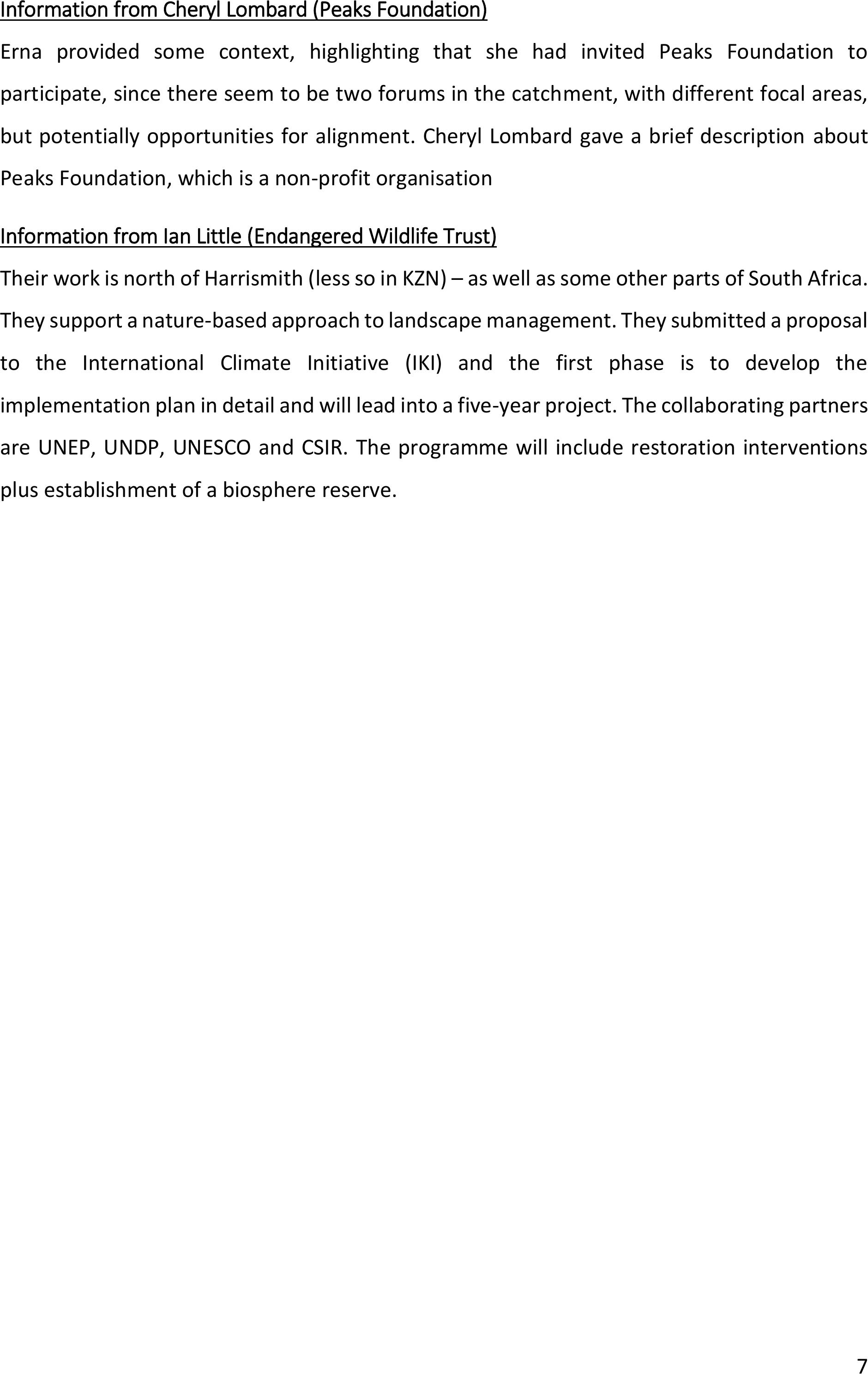
Information from Cheryl Lombard (Peaks Foundation)
Erna provided some context, highlighting that she had invited Peaks Foundation to
participate, since there seem to be two forums in the catchment, with different focal areas,
but potentiallyopportunities for alignment. Cheryl Lombard gave a brief descriptionabout
Peaks Foundation, which is a non-profit organisation
Information from Ian Little (Endangered Wildlife Trust)
Their work is north of Harrismith (less so in KZN) – as well as some other parts of South Africa.
They support a nature-based approach to landscape management. They submitted a proposal
to the International Climate Initiative (IKI) andthe first phase is to develop the
implementation plan in detail and will lead into afive-year project. The collaborating partners
are UNEP, UNDP, UNESCO and CSIR. The programme will include restoration interventions
plus establishment of a biosphere reserve.
8
Figure 6: This is the National EbA Guidelines – shared by Ian Little.
9
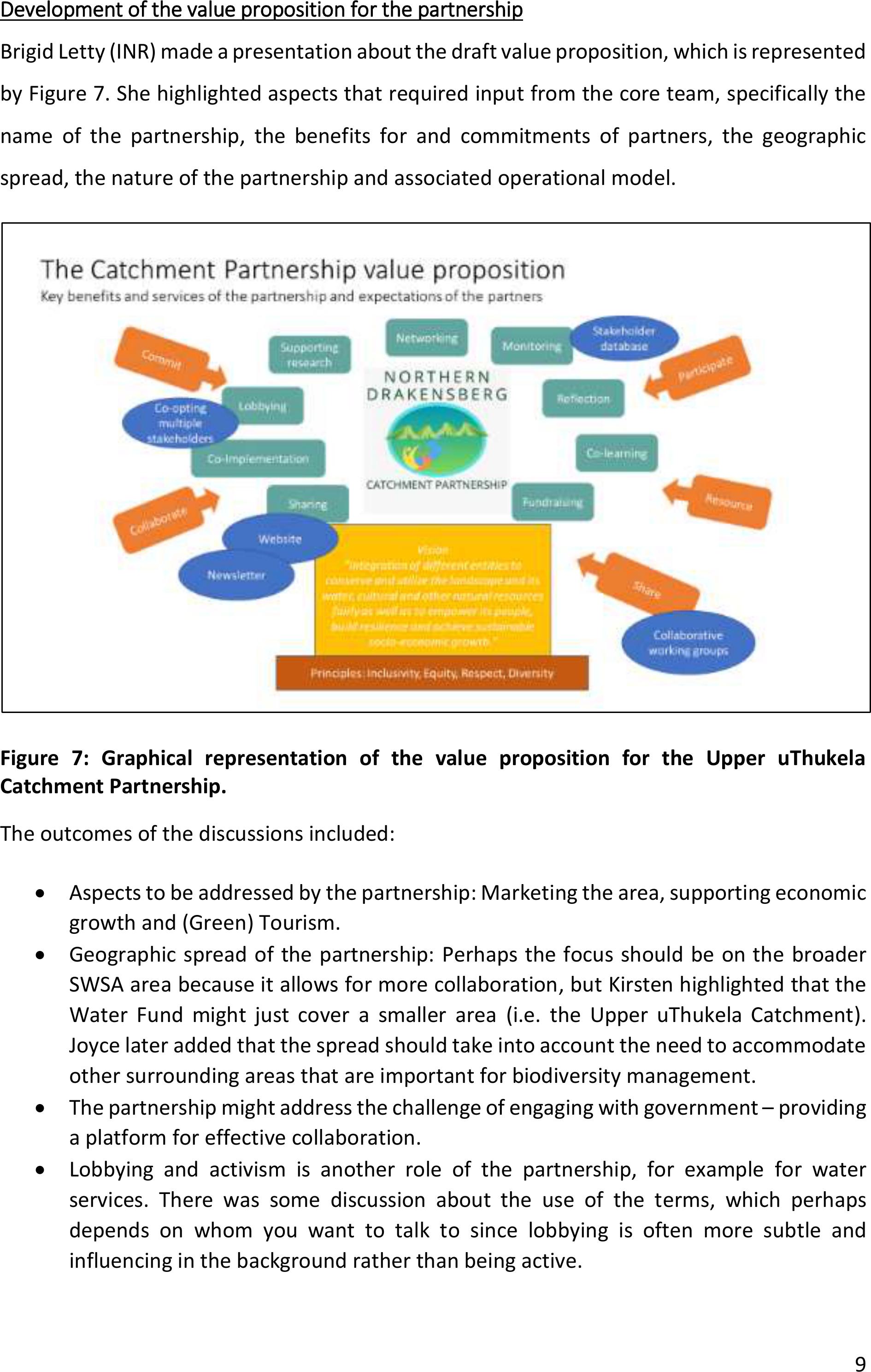
Development of the value proposition for the partnership
Brigid Letty (INR) made a presentation about the draft value proposition, which is represented
by Figure 7. She highlighted aspectsthatrequired input from the core team, specifically the
name of the partnership, the benefits for and commitments of partners, the geographic
spread, the nature of the partnership and associated operational model.
Figure 7: Graphicalrepresentation of the value proposition for the Upper uThukela
Catchment Partnership.
The outcomes of the discussions included:
•Aspects to be addressed by the partnership: Marketing the area, supporting economic
growth and (Green) Tourism.
•Geographic spread of the partnership: Perhaps the focus should be on the broader
SWSA area because it allows formore collaboration, but Kirsten highlighted that the
Water Fund might just cover a smaller area(i.e. the Upper uThukela Catchment).
Joyce later added that the spread should take into account the need to accommodate
other surrounding areas that are important for biodiversity management.
•The partnership might address the challenge of engaging with government –providing
a platform for effective collaboration.
•Lobbying and activism is another role of the partnership, for example for water
services. There was some discussion about the use of the terms, which perhaps
depends on whom you want to talk to since lobbying is often more subtle and
influencing in the background rather than being active.
10
•An agreement to be signed by partners was discussed. An MoU would show areas of
collaboration and could be accompanied by a 5-year strategy.
•In terms of the leadership of thepartnership, it was suggested that the coordinating
& administrative role should notbe rotated and the organisation taking on this role
needs to know that they are assuming all roles including resourcing the partnership.
•There was discussion about having a membership fee, but therewas aconcern with
this approach that it might make some partners reluctant to participate.
•It was suggested that an alternative to a membership fee would be to provide space
for any partner that is willing to resource a particular activity, to do so.
•Samir suggested that it’s a balancing act at early stages, since we want enough
commitment (e.g. MoU) but not so much that people are chased away. Thus, we
should make participation as easy as possible at this stage. Then at later stage,
increase the level of commitment, based on benefits of the partnership being
demonstrated. The UCP has been challenging because 37 organisations signed up but
most do not participate actively orspeak, even if they attend, but ithas created
legitimacy.
•There could be tiers to engagement –participate versus sign on as funding members
playing a more active role.
•Division of labour between partners might work (e.g. communication, funding, etc).
•Kathleen suggested that a continued dedicated coordination function is required for
the partnership, and that a formal constitution would give the group and the
coordinator legitimacy.
•EFTEON, as a partner that can provide services to enable research and data storage
capability, would find it beneficial if the MOU / membership would bypass some
processes to engage in the catchment (i.e. a “passport” to work in the space). They
will make a commitment to the group to comeinto communal spaces to reflect and
share data digitally. As a member of SAEON/NRF, it is much easier for EFTEON to do a
sponsorship of x meetings / year plus a membership fee.
•Andrew highlighted that finding a single document that can satisfy many stakeholders
in challenging as we need to accommodate everyone’s needs and what they can
contribute. Thus, it is better to focus on principles rather than detail. Solid governance
foundation is necessary, especially if fundraising.In terms of locality, it makes sense
to protect as SWSA and then within this there might be activities that focus on certain
portions.
•Kirsten raised questions that the value proposition and operational model must
consider: What is the objective of a partnership as an entity…. And who drives it? And
how do they get funded? And what do they do? And how does the responsible body
resource it moving forward? Samir responded that all WWF funding proposals have a
portion of the budget for partnership building as a sustainability and governance
mechanism.
•There was discussion about whether the partnership should function as a catchment
management forum (CMF). Samir highlighted that since the CMF ischaired by
government, which inevitably brings with it expectations from stakeholders, and
11
people speak to government rather than to each other. A partnership that is not seen
as a government-led structure will provide more space for innovation. It was
suggested thatthe partnership should be a member of the CMF, which allows the
partnership to retain its independence.
•Erna added that to take the commentsforward, we should not formalise the
partnership with an entity, and rather have a generalised MoU with a focus on sharing.
Then through this develop small communities of practice (CoPs) that can focus on
action.
•Regarding leadership and governance, it was suggested that the partnership could
have two co-chairs and an operational secretariat that reports to them. Individuals
could be allocated specific portfolios such as communications, research, etc, but
thought will need to be given to how they are resourced.
•Kirsten talked about the need for synergy with existing committees such as
partnership committees sitting on protected areas.
•Kathleen said that EFTEON could contribute paid man-hours of their team to support
activities such as convening meetings or serve on the committee. They could
potentially also provide transport for local stakeholders to attend meetings.
•Samir asked Andrew whether he knows of a company thatmight have appetite to fund
the secretariat. His response was that there might be interest from the AHA group.
Andrew added thatthe partnership can start to attract its ownfunding and that we
could call the core team a developmental team that identifies what needs to be done
and see this as a process, even considering the biosphere.
•Rebecka had a question for Samir about long term funding prospects if we get a well
established partnership, given that WWF has been funding the convening team.He
responded if we establish a strong partnership it increases our chances of fundraising
– for implementation and coordination. Even the coca cola scoping study could
support the partnership.
•Kirsten suggested that there will be initiatives bringing in opportunities – such as the
Water Fund, so the committee needs to see ‘who will do what’ for a particular year.
•Erna added that we need a generic low cost core team that can be held as a secretariat
that undertakes partnership-related activities within their own work programmes. The
formal structure cancome in later when we get to ‘doing things’. For now, ‘integrate
and volunteer’ should be the principle. Activities of the secretariat need to be taken
on voluntarily by members when funding is lean and then when funding is secured,
funded persons are included, to undertake specific activities. Perhaps partnering
organisations can undertake to get some funding under their portfolios for
collaboration.
•Discussion about the name ledto the suggestion: Northern Drakensberg Collaborative
(NDC).
•Regarding the agreement, it was highlighted that MoA is a legal document butanMOU
is not. It was suggested that the latter would be more appropriate.
•There was a question about how incoming funds would be handled and for the
moment they would be held by partner organisations.
12
Planning for the May workshop
Erna Kruger (Mahlathini Development Foundation) took us through the lastsession of the day
focusing on the workshop to be held in May 2023.
2.2.2 Physical meeting of the upper uThukela Partnership in May 2023
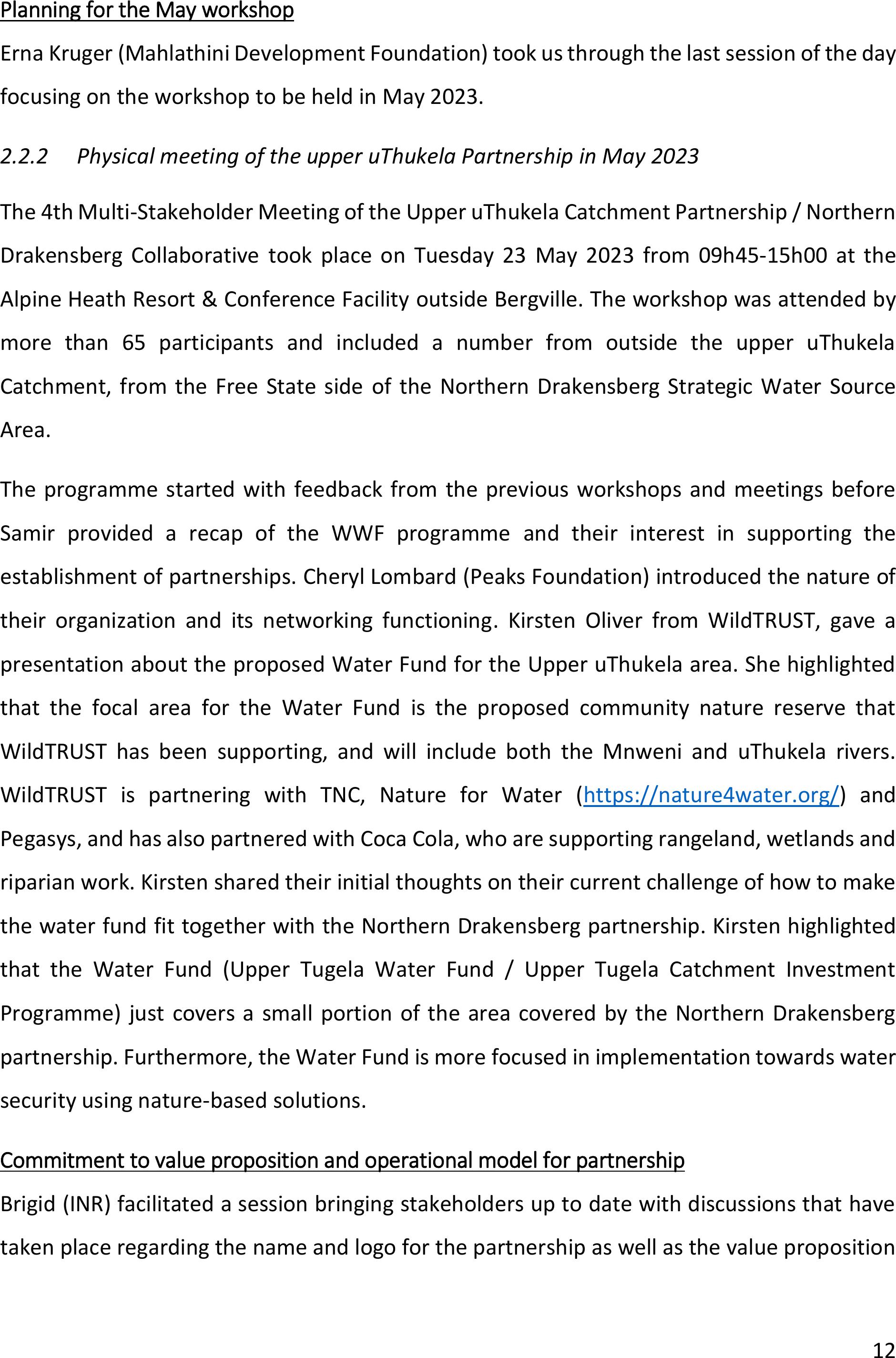
The 4th Multi-Stakeholder Meeting of the Upper uThukela Catchment Partnership / Northern
Drakensberg Collaborative took place on Tuesday 23 May 2023 from 09h45-15h00 at the
Alpine Heath Resort & Conference Facility outside Bergville. The workshop was attended by
more than 65 participants and included a number from outside the upperuThukela
Catchment, from the Free State side of the Northern Drakensberg Strategic Water Source
Area.
The programme started with feedback from the previous workshops and meetings before
Samir provided a recap of the WWF programme and their interest in supporting the
establishment of partnerships. Cheryl Lombard (Peaks Foundation) introduced the nature of
their organization and its networking functioning. Kirsten Oliver from WildTRUST, gave a
presentation about the proposed Water Fund for the Upper uThukela area. She highlighted
that the focal area for the Water Fund is the proposed community nature reserve that
WildTRUST has been supporting, and will include both the Mnweni and uThukela rivers.
WildTRUST is partnering with TNC, Nature for Water (https://nature4water.org/) and
Pegasys, and has also partnered with Coca Cola, who are supporting rangeland, wetlands and
riparian work. Kirsten shared their initial thoughts on their current challenge of how to make
the water fund fit together with the Northern Drakensberg partnership. Kirsten highlighted
that the Water Fund (Upper Tugela Water Fund / Upper Tugela Catchment Investment
Programme) just covers a small portion of the area covered by the Northern Drakensberg
partnership. Furthermore, the Water Fund is more focused in implementation towards water
security using nature-based solutions.
Commitment to value proposition and operational model for partnership
Brigid (INR) facilitated a session bringing stakeholders up to date with discussions that have
taken place regarding the name and logo for the partnership as well as the value proposition
13
(services/benefits that thepartnership offers) and commitments that are required from its
members (see Error! Reference source not found.).
Due to time constraints, there was limited opportunity to discuss the operational model
beyond mentioning aspects to be considered. And time was given to allow partners to reflect
on what resources that could bring to the partnership. Highlighted why the move towards the
name, and the commitment statement. We circulated copies of the statement for discussion.
Some of the key points related to partners resourcing the partnership that emerged from
discussions, and which were captured on flipchart paper, were:
•EFTEON to support meeting costs and transport of local stakeholders to meetings
•Peaks Foundation willing to provide website support
•Cheryl at Peaks Foundation also highlighted that the collective includes a vast array of
experience andexpertise (e.g. business people, government representatives) who can
contribute with skills such as financial management, strategic planning, and other.
•Ezemvelo willing to provide advice and technical support
•The point was raised that all organisations can contribute their time and participants
should request their managers to allow them to participate or should provide time for
their staff to attend
•DFFE can provide herbicides and assist with bush encroachment assessments and
developing management plans
•EDTEA representatives highlighted that there is currently a call out from the Operation
Vula Fund.
•Endangered Wildlife Trust –assisting community member to participate, become self-
sustaining so as to be able to get more support (i.e. fundraising)
•DWS – can contribute skills, expertise, volunteering and facilitation
•The manager of Golden Gate National Park made a few points:
oWith a collaboration, the output must be more than the sum of the parts (i.e.
more achieved working collectively than independently)
oThere is a need for them to be able to work outside their boundaries because
they are providing employment for youth, but its restricted to the park
oWe need to blow the whistle – where does the water come from?
•Amazizi Wilderness group, community-based NPO asked for assistance with capacity
building related to fundraising so that they have resources to use to create awareness
in the community about water quality and to fund some activities to address pollution
entering water systems
•UKZN and other universities –can support co-generation of knowledge and co-
sharing, but it is important that communities and other stakeholders are involved in
the co-design of research priorities
•A point was raised that having no resources can also be a resource because it leads to
innovative ideas about how to do things differently
14
There was a discussion about the process that has been followed in starting to develop a
memorandum of understanding (MoU) for the partnership, and then taking a decision to step
backwards and rather develop a one-page commitment statement that allows organisations
to commit to being part of the process of developing the partnership, including co-developing
an MoU that meets the needs ofthe members. There was also some discussion about how
we improve the level of sharing and interaction between members of the partnership. Due to
legislation around sharing personal information, we need permission from partners to share
their emails and their numbers. One option suggested was to use a Googlegroup to allow
email sharing, which hides individual emails, and we can have a process of collecting cell
numbers for whatsapp whereby those who do not want to are excluded. The commitment
form will be shared via email and local organisations such as WildTRUST will assist with
printing and circulating the commitment forms to ensure that all members are able to access
it. Moving forward we will use the gmail address for the partnership, which is:
northerndrakensberg@gmail.com
Another point was raised by arepresentative of the Bakoena Royal Council, who highlighted
that the MoU for the partnership needs to consider the land administration dynamics of
different stakeholder groups.
Communities of practice
Rebecka facilitated the session that introduced the idea of establishing working groups (they
could be called themes, communities of practice (CoPs) or sub-committees). We had intended
to break away into working groups to identify proposed interventions but time did not allow
for this. However, we did add working groups based on earlier discussions: (1) the MoU
development; and (2) Capacity building and awareness raising –including fundraising; (3)
Collaborative implementation – including financing options.
Rebecka highlighted that some people might be interested in different themes/working
groups, either as participants or leaders, so the convening team will be engaging the
partnership members via email to take this forward. She undertook to make a GoogleGroup
and then circulate a form indicating interest in working groups, as well as giving consent for
mobile phone numbers to be included in the whatsapp group. For those without email, the
conveners will send the form via organisations working in communities so that all can
participate. Rebecka then talked about the core advisory group and asked that participants
15
come to her after the session if they would like to be a memberof the group –there were
requests from participants from EDTEA and DFFE to be included in the core team. Rebecka
highlighted that this is only an interim structure that is supporting the process of establishing
the partnership. Brigid reminded newparticipants to fill in the location of their work on the
map before leaving today – continuing the participatory mapping process that was started at
the previous multi-stakeholder workshop that was held in November 2022 in Bergville.
Update on the PepsiCo project progress
Mbongiseni Shongwe (WildTRUST) talked to the targets for clearing(hectares, person-days,
replenishment figures) and progress against these targets. Mfundo Myende (INR) then
explained how the restoring complements the clearing work of WildTRUST at AmaSwazi and
uses material from clearing to build structures on contours to slow water and hold sediment.
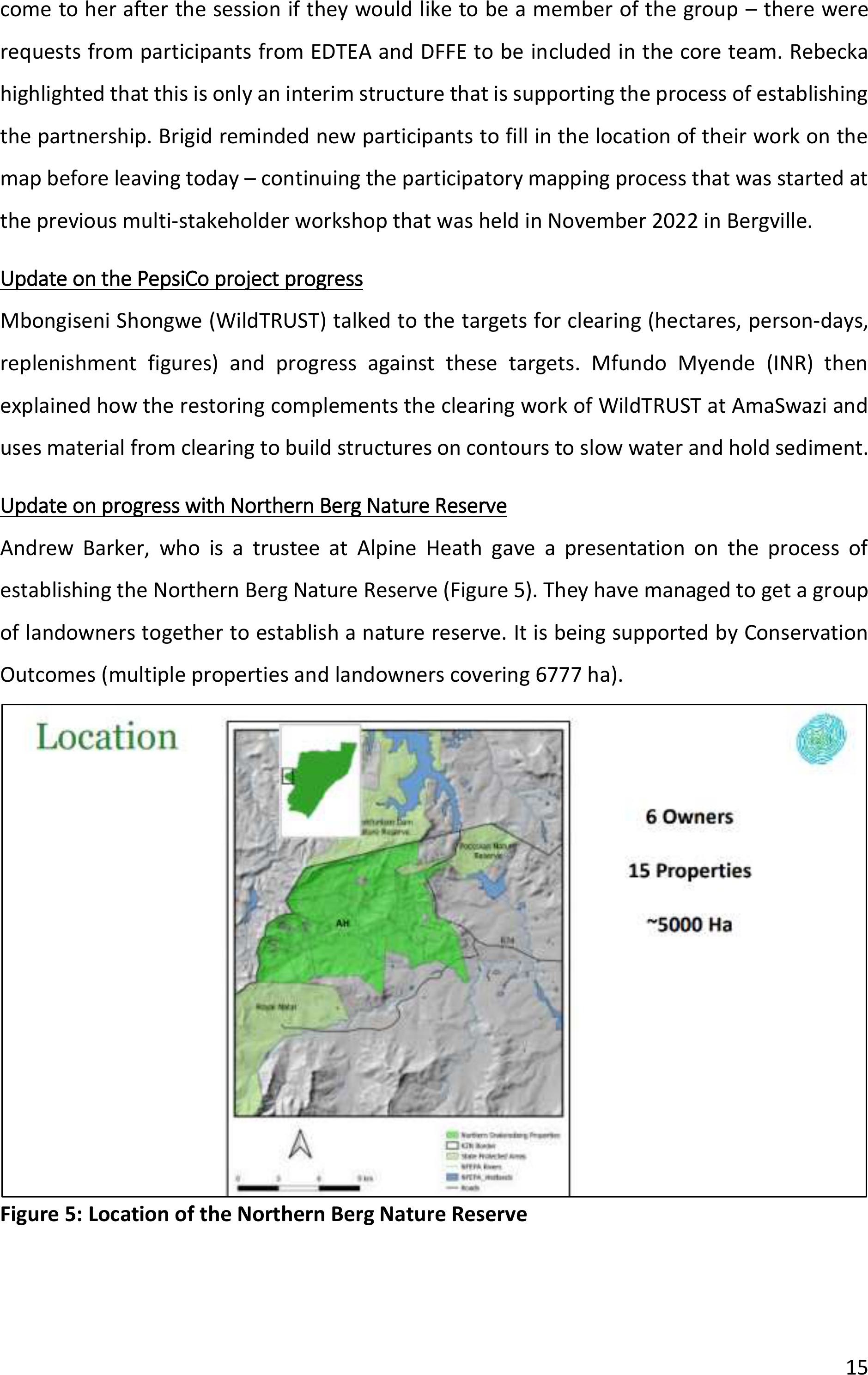
Update on progress with Northern Berg Nature Reserve
Andrew Barker, who is a trustee at Alpine Heath gave a presentation on the process of
establishing the Northern Berg Nature Reserve (Figure 5). They have managed to get a group
of landowners together to establish a nature reserve. It is being supportedby Conservation
Outcomes (multiple properties and landowners covering 6777 ha).
Figure 5: Location of the Northern Berg Nature Reserve
16
Update from EFTEON about their work in the catchment
Kathleen Smart (EFTEON) introduced her colleagues who shared what they are doing in the
landscape, and also provided an update on other activities (Figure 6). Weather stations have
been installed with Mahlathini and the Ecochamps at Ezimboveni, so they will make a link
available for public to see the information. EFTEON PhD student from UFS, Toka Mosikidi, will
be doing biomonitoring using instruments that record sound from which they can measure
biodiversity. They will need partnerships with nature areas and protected areas to do the
monitoring. Sachin Doarsamy, who has recently joined EFTEON, is a botanist and will be
leading work related to the Socio-ecological Observatory for Studying African Woodlands
(SEOSAW). He has started at Spionkop and will now identify other sites. This is related to
tracking changes in African woodland (including bush encroachment), possibly due to human
disturbances, fire intervals, temperature and climate change.
Update on EWT about the Grassland Biosphere Reserve
There was a short input from Bradley Gibbons from EWT about the process of establishing a
grassland biosphere reserve. He showed a protected areas expansion map based on
protecting high priority areas.
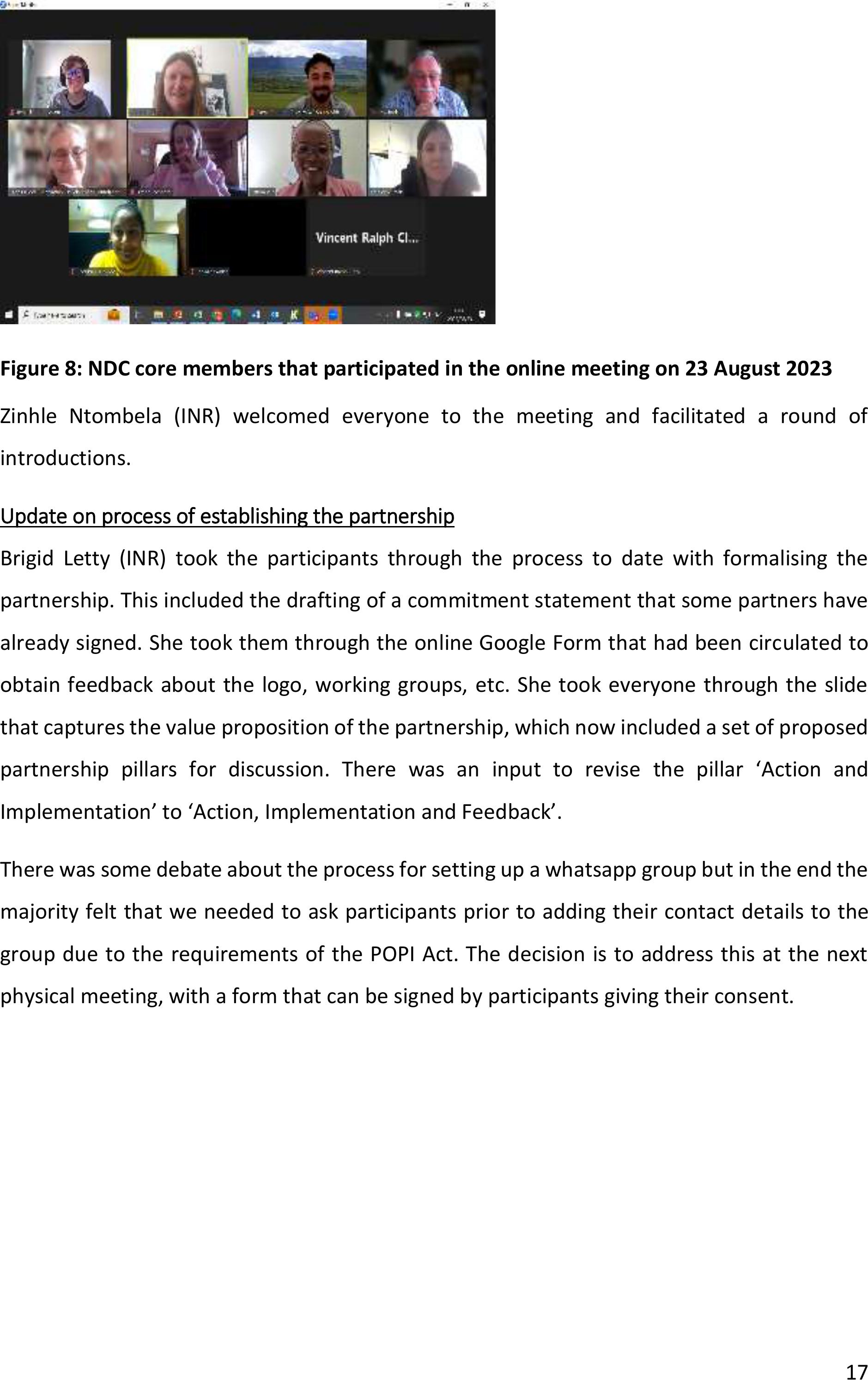
2.2.3Online NDC core team meeting on 23 August 2023
A meeting of the NDC core team took place online on 23 August 2023 from 11h00 – 13h30. It
was attended by Erna Kruger (Mahlathini Development Foundation), Brigid Letty (Institute of
Natural Resources, INR), Zinhle Ntombela (INR), Rebecka Henriksson (Centre for Water
Resources Research, CWRR), Corrina Naidoo (SAEON), Ian Rushworth (Ezemvelo KZN
Wildlife), Michael Malinga (Mahlathini), Anton Lombard (Peaks Foundation), Samir Randera-
Rees (WWF), SachinDoarsamy (EFTEON), Kathleen Smart (EFTEON), Cheryl Lombard (Peaks
Foundation) and Ralph Clark (Afromontane Unit at University of Free State, AMU). Apologies
were received from Minesh Sookamdev (DFFE), Jacky Jay (DFFE), Bawinile Mtolo (Mnweni
Wilderness Group), Kirsten Oliver (WILDTRUST), and Joyce Loza (MDTP)
17
Figure 8: NDC core members that participated in the online meeting on 23 August 2023
Zinhle Ntombela (INR) welcomed everyone to the meeting and facilitated a round of
introductions.
Update on process of establishing the partnership
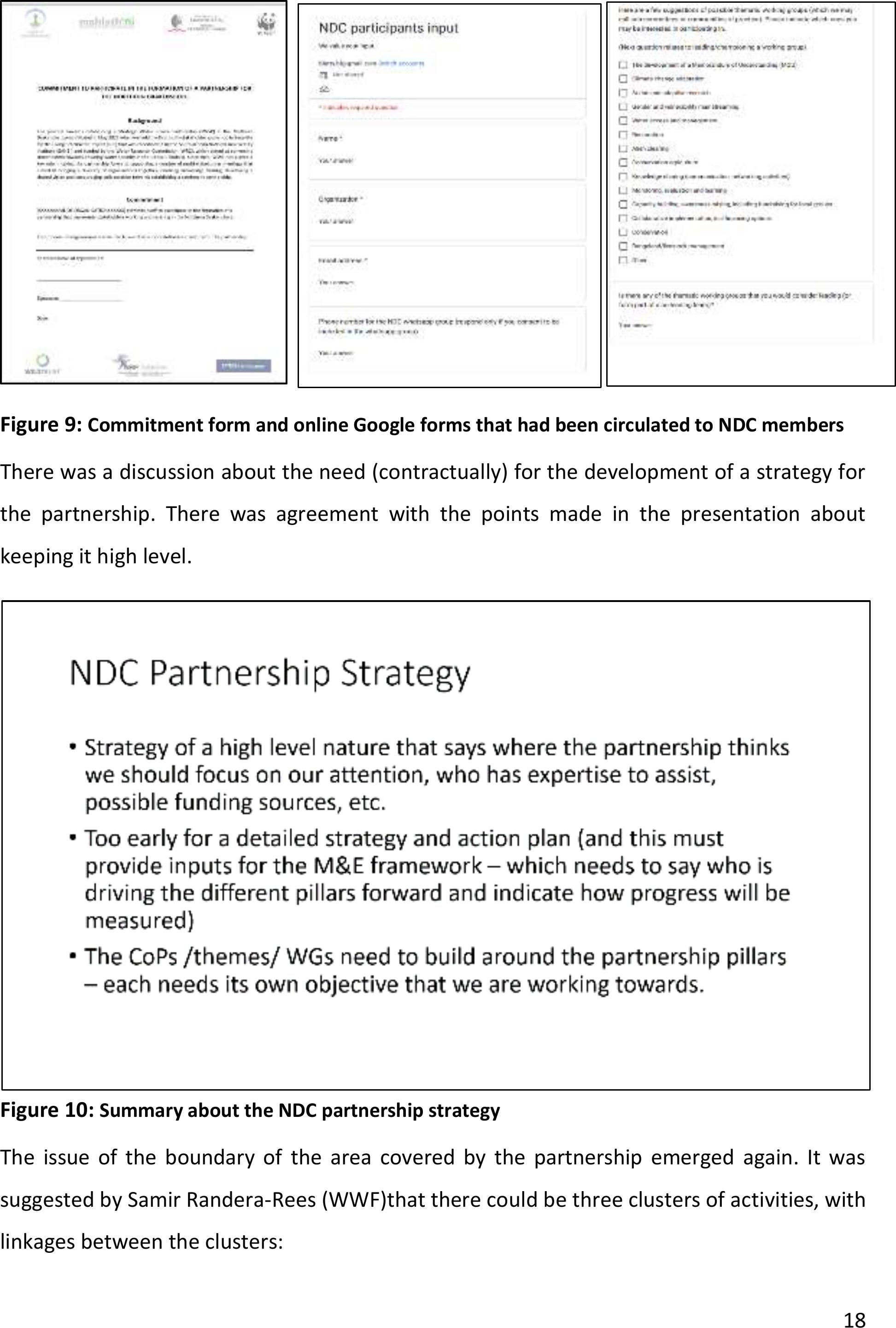
Brigid Letty (INR) took the participants through the process to date with formalising the
partnership. This included the drafting of a commitment statement that some partners have
already signed. She took them through the online Google Form that had been circulated to
obtain feedback about the logo, workinggroups, etc. She took everyone through the slide
that captures the value proposition of the partnership, which now included a set of proposed
partnership pillarsfor discussion. There was an inputto revise the pillar ‘Action and
Implementation’ to ‘Action, Implementation and Feedback’.
There was some debate about the process for setting up a whatsapp group but in the end the
majority felt that we needed to ask participants prior to adding their contact detailsto the
group due to the requirements of the POPI Act. The decision is to address this at the next
physical meeting, with a form that can be signed by participants giving their consent.
18
Figure 9: Commitment form and online Google forms that had been circulated to NDC members
There was a discussion about the need (contractually) for the development of a strategy for
the partnership. There was agreement with the points made in the presentation about
keeping it high level.
Figure 10: Summary about the NDC partnership strategy
The issue of the boundary of the area covered by the partnership emerged again. It was
suggested by Samir Randera-Rees (WWF)that there could be three clusters of activities, with
linkages between the clusters:
19
●Free State (Upper Wilge) – which includes Witsieshoek and QwaQwa, which is where
UFS is very active.
●Upper uThukela
●Upper Vaal / grasslands area – where BirdLife and EWT are active.
Andrew Barker suggested that we do not have to have a very defined boundary, but as the
working groups start, we might have to distinguish between core and peripheral areas.
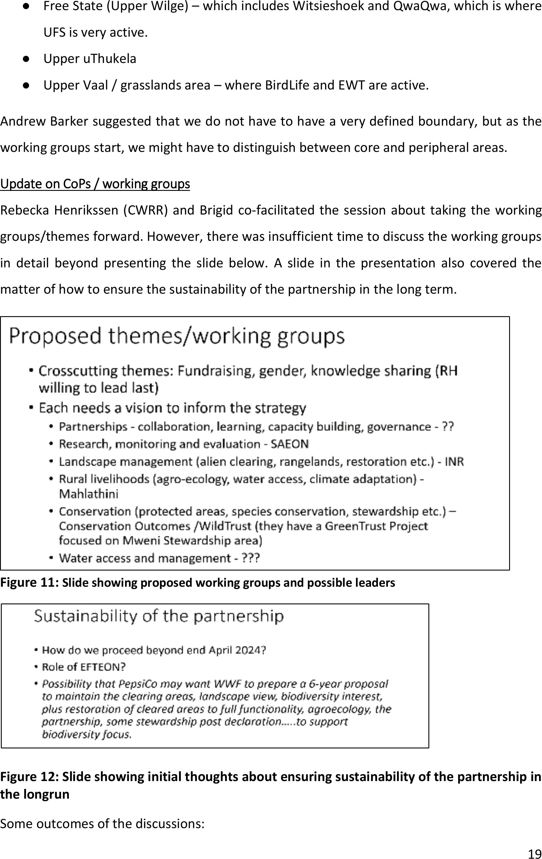
Update on CoPs / working groups
Rebecka Henrikssen (CWRR) and Brigid co-facilitated the session about taking the working
groups/themes forward. However, there was insufficient time to discuss the working groups
in detail beyond presenting the slide below. A slide in the presentation also covered the
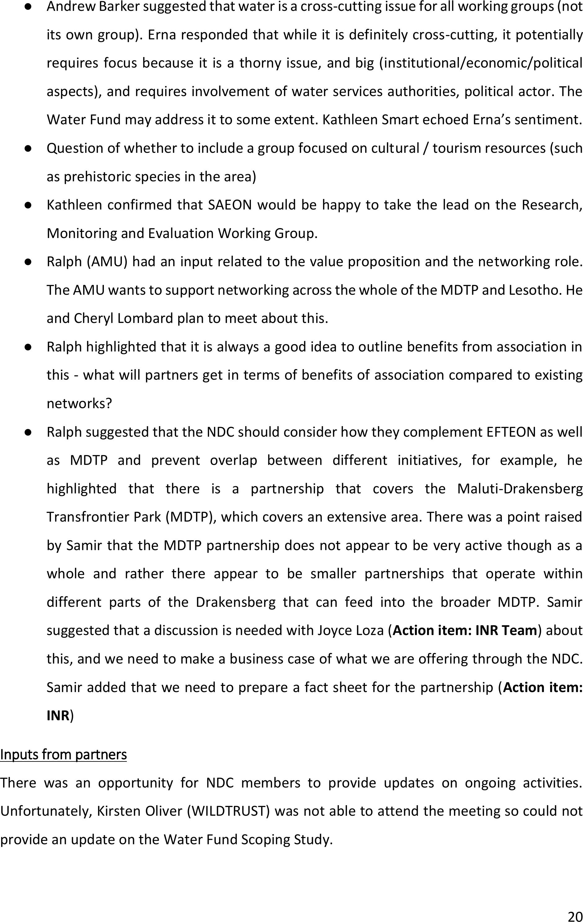
matter of how to ensure the sustainability of the partnership in the long term.
Figure 11: Slide showing proposed working groups and possible leaders
Figure 12: Slide showing initial thoughts about ensuring sustainability of the partnership in
the longrun
Some outcomes of the discussions:
20
●Andrew Barker suggested that water is a cross-cutting issue for all working groups (not
its own group). Erna responded that while it is definitely cross-cutting, it potentially
requires focus because it is a thorny issue, and big (institutional/economic/political
aspects), and requires involvement of water services authorities, political actor. The
Water Fund may address it to some extent. Kathleen Smart echoed Erna’s sentiment.
●Question of whether to include a group focused on cultural / tourism resources (such
as prehistoric species in the area)
●Kathleen confirmed that SAEON would behappy to take the lead on the Research,
Monitoring and Evaluation Working Group.
●Ralph (AMU) had an input related to the value proposition and the networking role.
The AMU wants to support networking across the whole of the MDTP and Lesotho. He
and Cheryl Lombard plan to meet about this.
●Ralph highlighted that it is always a good idea to outline benefits from association in
this - what will partners get in terms of benefits of association compared to existing
networks?
●Ralph suggested that the NDC should consider how they complement EFTEON as well
as MDTP and prevent overlap between different initiatives,for example, he
highlighted that there is a partnership that covers the Maluti-Drakensberg
Transfrontier Park (MDTP), which covers an extensive area. There was a point raised
by Samir that the MDTP partnership does not appear to be very active though as a
whole and rather there appear to be smaller partnerships that operate within
different parts of the Drakensberg that can feed into the broader MDTP. Samir
suggested that a discussion is needed with Joyce Loza (Action item: INR Team) about
this, and we need to make a business case of what we are offeringthrough the NDC.
Samir added that we need to prepare a fact sheet for the partnership (Action item:
INR)
Inputs from partners
There was an opportunity for NDC members to provide updates on ongoing activities.
Unfortunately, Kirsten Oliver (WILDTRUST) was not able to attend the meeting so could not
provide an update on the Water Fund Scoping Study.
21
Update on the situational assessment report
Brigid provided an overview of the situational analysis reportprepared for WWF andobtained
some additional inputs from Meeting participants, in addition to those shared ahead of the
meeting by Ralph Clark and Ian Rushworth. Ian Rushworth (Ezemvelo KZN Wildlife) provided
input. He highlighted the following points:
●Restoration work was done by himself, plus Ecochamps.
●He had thought it was the whole NDSWSA and about water.
●Need recognition of the water security issue – world heritage site – main role is water
production, state has thus invested in it – now seeing benefits of visions of the
1930s/40s.
●Linked to this –the colonial government recognized plantations were going to impact,
so catchment experiments were set up in cathedral peak –longest running burning
experiments –outputs have helped us understand relationships between burning,
woody species and water. Climate change data. Data that led to the WfW programme
… linking alien trees to water production.
●Protected area maps need to be revised.
●Land degradation and historical policies –look at the positives…..
●Environmental degradation – 2000s study about tenure and soil carbon.
●Invasive alien species –need to capture extent of the problem –he can contribute.
Emerging spread.
●Big threat –Pinus patchela–spreading from original plantings, now a massive problem
in the mountain areas. Wattle also, despite efforts.
●Figure 24 in the report refers to Lespedeza…. Seems to be spreading everywhere. He’s
concerned about it being promoted as a crop.
●Environmental degradation –alien plant control done by government. Also,
Ezemvelo’s own budget.
●Don’t make the assumption that the protected areas are safe. Just no resources
available. R6/ha operational budget this year. Need to protect what is still intact.
●Check figures around pump storage schemes. Percentages might have all changed.
●Look for newer documents that are available – the MDTP doc (just signed off) –get it
from Ian.
22
●Stewardship – get the details for the additional areas.
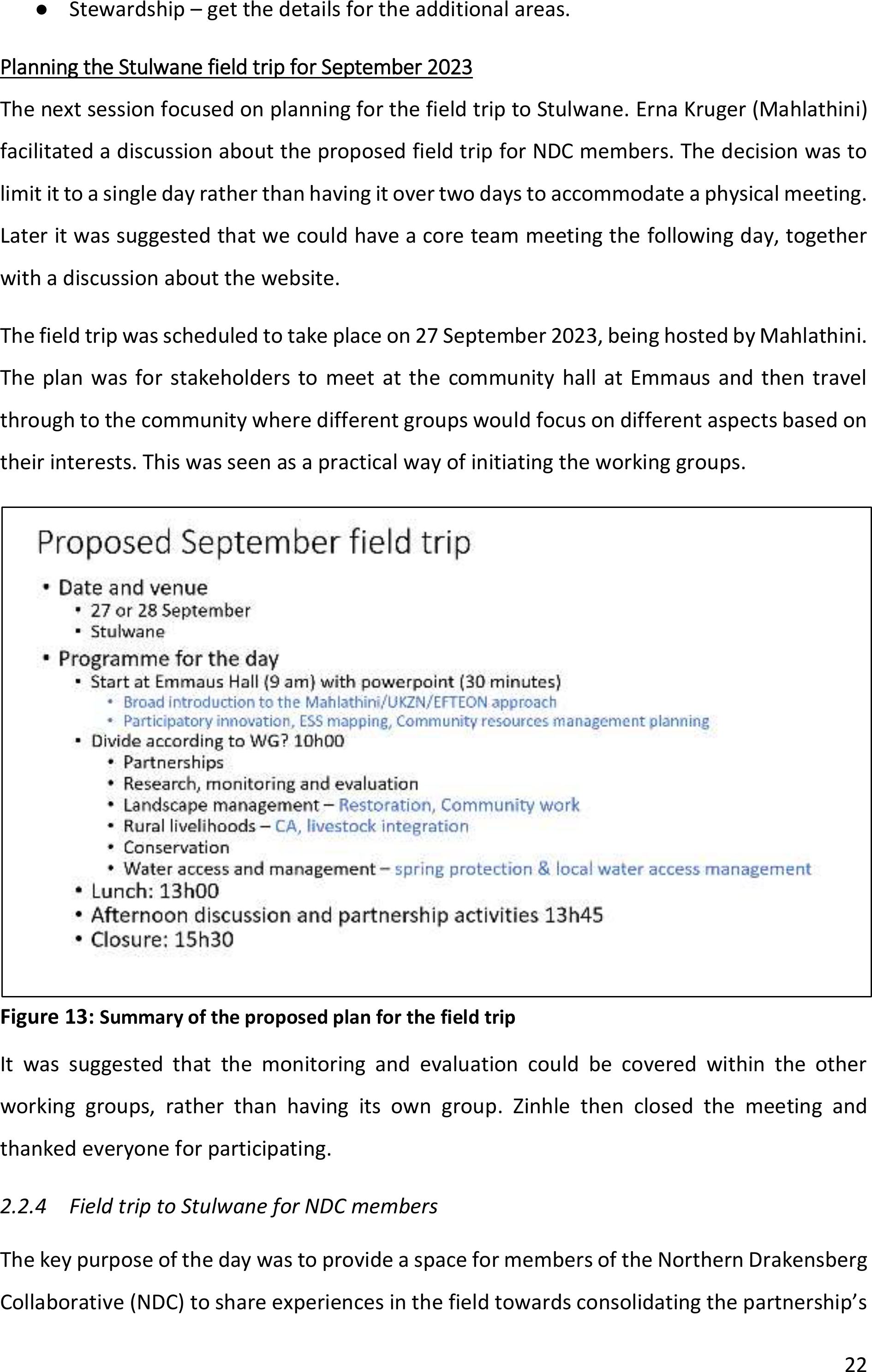
Planning the Stulwane field trip for September 2023
The next session focused on planning for the field trip to Stulwane. Erna Kruger (Mahlathini)
facilitated a discussion about the proposed field trip for NDC members.The decision wasto
limit it to asingle day rather than having it over two days toaccommodate a physical meeting.
Later it was suggested that we could have acore team meeting thefollowing day,together
with a discussion about the website.
The field trip was scheduled to take place on27 September 2023, being hostedby Mahlathini.
The planwas for stakeholders to meet at the community hall at Emmaus and then travel
through to the community where different groups would focus on different aspects based on
their interests. This was seen as a practical way of initiating the working groups.
Figure 13: Summary of the proposed plan for the field trip
It was suggested that the monitoring and evaluation could be covered within the other
working groups, rather than having its own group. Zinhle then closed the meeting and
thanked everyone for participating.
2.2.4Field trip to Stulwane for NDC members
The key purpose of the day was to provide a space for members of the Northern Drakensberg
Collaborative (NDC) to share experiences in the field towards consolidating the partnership’s
23
key themes / working groups. Since the field trip was initiated by a session at the Emmaus
community hall, there was also opportunity for team members of the MAPWAPS project (full
title: Mapping woody invasive alien plant species and their impacts in strategic water source
areas) to provide input as they wanted to use the opportunity to update NDC members.
The event was attended by the following organisations: African Conservation Trust (ACT),
WILDTRUST, Mahlathini Development Foundation, Institute of Natural Resources (INR),
Agricultural Research Council (ARC), Ezemvelo KZN Wildlife (EKZNW), Endangered Willdlife
TRUST (EWT), KZN No-till Club, Expanded Fresh Water and Terrestrial Earth Observation
Network (EFTEON), University of KwaZulu-Natal’s Centre for Water Resources Research
(UKZN-CWRR), Maluti-Drakensberg Transfrontier Programme (MDTP) and community
members from AmaZizi, AmaNgwane and AmaSwazi.
Apologies were receivedfrom representatives of Department of Forestry, Fisheries and the
Environment (DFFE), University of the Free State (UFS), Northern Drakensberg Nature
Reserve, Peaks Foundation, WWF, Conservation Outcomes and the Department of Water and
Sanitation (DWS).
The following summary of the field tripwas prepared by Hlengiwe Hlongwane (Mahlathini
Development Foundation): On the 27thof September 2023, there was a Northern
Drakensberg Collaborative engagement in Emmaus Hall, with different stakeholders from
different organisations working inthe Uthukela catchment, and a field visit to Stulwane to see
the work Mahlathini DF.
MapWaps project update
The day started with introductions, then a presentation from Stellenbosch PHD and master’s
students, Liam and Thandeka, working on the MapWaps project, which is a project that is in
the Uthukela catchment (and other catchments in SA) that is fundedby the WRC and maps
out woody alien invasive species (Wattle, Gumtrees and Popular) and estimate their water
impacts in strategic water areas, as well as their economic impacts. This project will run from
the 12th-26th of October in the Uthukela catchment and those interested to join the work are
invited to do so on these days.
24
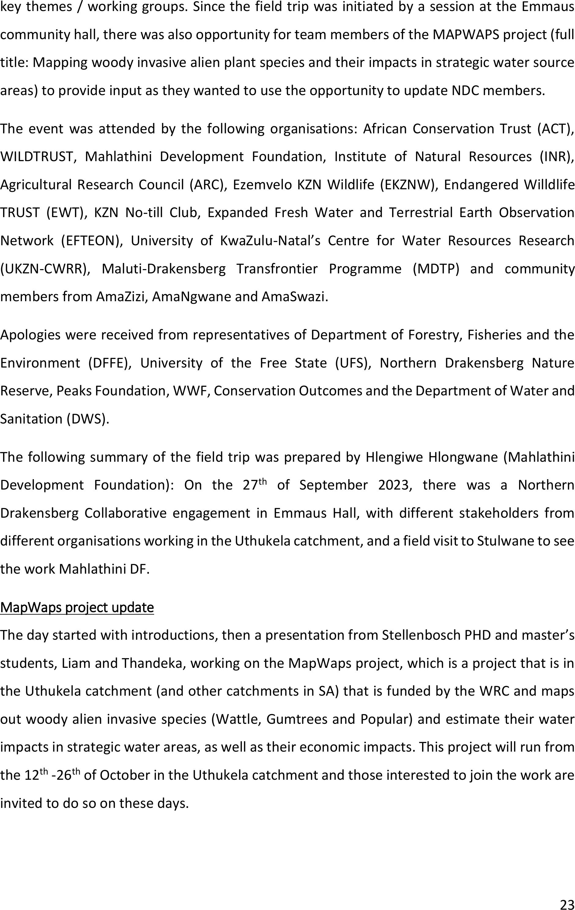
Introduction to the work of Mahlathini
A presentation from Mahlathini by Temakholo Mathebula followed, which gave an idea or an
image of who Mahlathini is, how it works and what it does, from establishing learner groups,
doing farmer-led experimentations, collaborations, and relationships in the areas MDF works
in. an Ecological map created with the communities pointing out water natural resources such
as water sources, grazing lands, wetlands, other key areas that need intervention such as
erosions, alien plants, etc. was used as an example of the processes that MDF go through with
farmers. The presentation then got into more detailabout what came out from the
discussions that MDF-WRC had with the two communities (Ezibomvini and Stulwane), which
included the identification of key areas, theirimportance, interventions required, and
stakeholders involved, and then the outcomes of those discussions and plans made which is
the community working together voluntarily to clear pollution and invasive alien species and
doing Restorations. There was also a brief description of the other work that MDF does, such
as the water access projects, CA and its principles, livestock integrations and organic intensive
home gardening.
Figure 14: Presentation From Mahlathini, by Temakholo Mathebulo
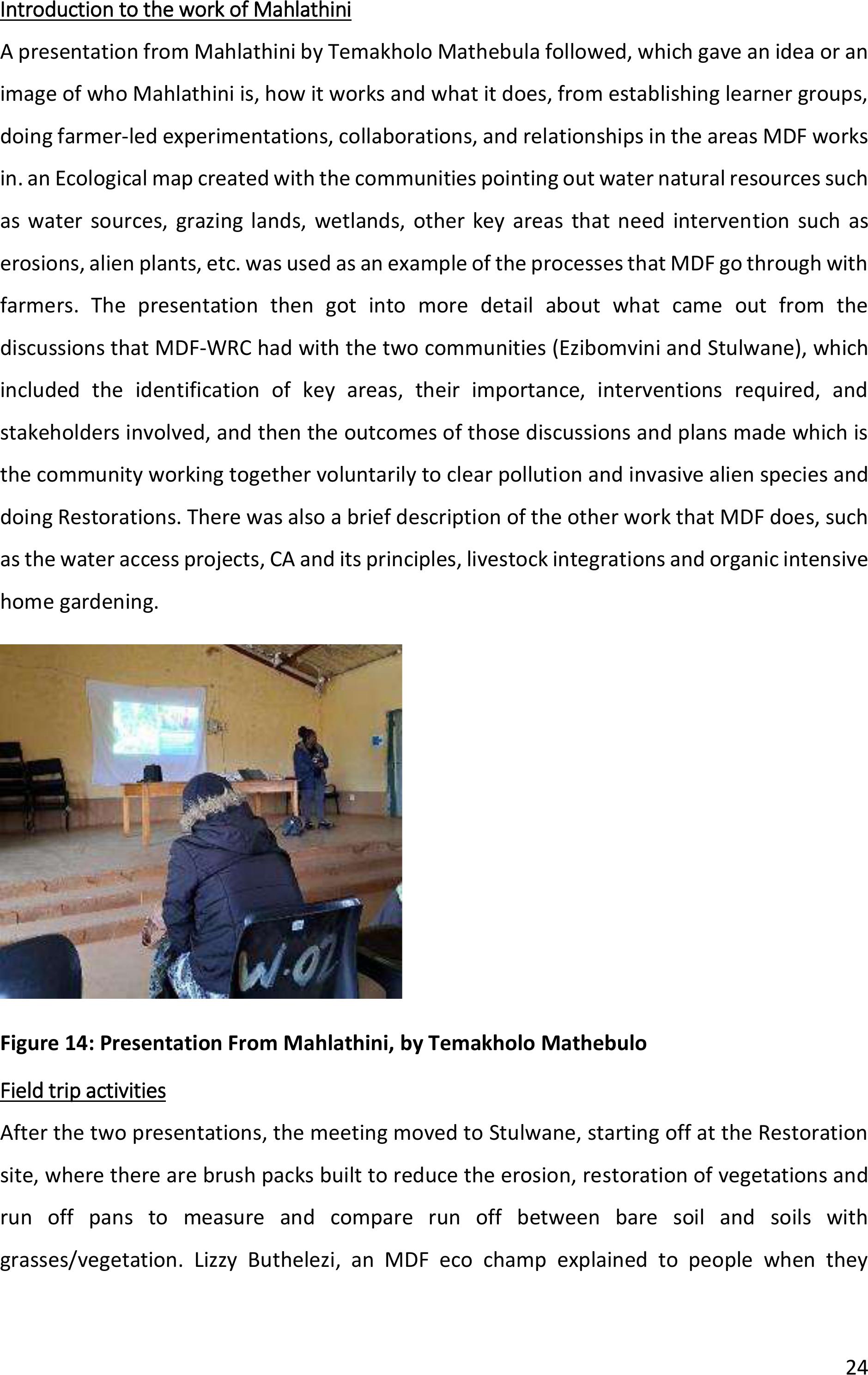
Field trip activities
After the two presentations, the meeting moved to Stulwane, starting off at the Restoration
site, where there are brush packs built to reduce the erosion, restoration of vegetations and
run off pans to measure and compare run off between bare soil and soils with
grasses/vegetation. Lizzy Buthelezi, an MDF eco champ explained to people when they
25
started working on the restoration site, how it looked like before, how they built the brush
packs and tools used to make contours, and the purpose of it.
Figure 15: Restoration site visit at Stulwane
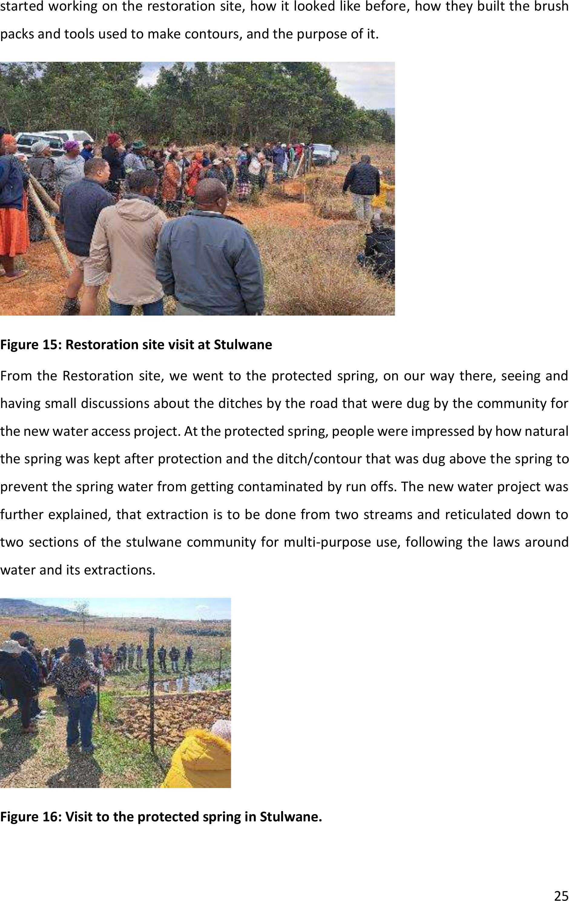
From the Restoration site, we went to the protected spring, on ourway there, seeing and
having small discussions about the ditches by the road that were dug by the community for
the new water access project. At the protected spring, people were impressed by how natural
the spring was kept after protection and the ditch/contour that was dug above the spring to
prevent the spring water from getting contaminated by run offs. The new water project was
further explained, that extraction is to be done from two streams and reticulated down to
two sections of the stulwane community for multi-purpose use, following the lawsaround
water and its extractions.
Figure 16: Visit to the protected spring in Stulwane.
26
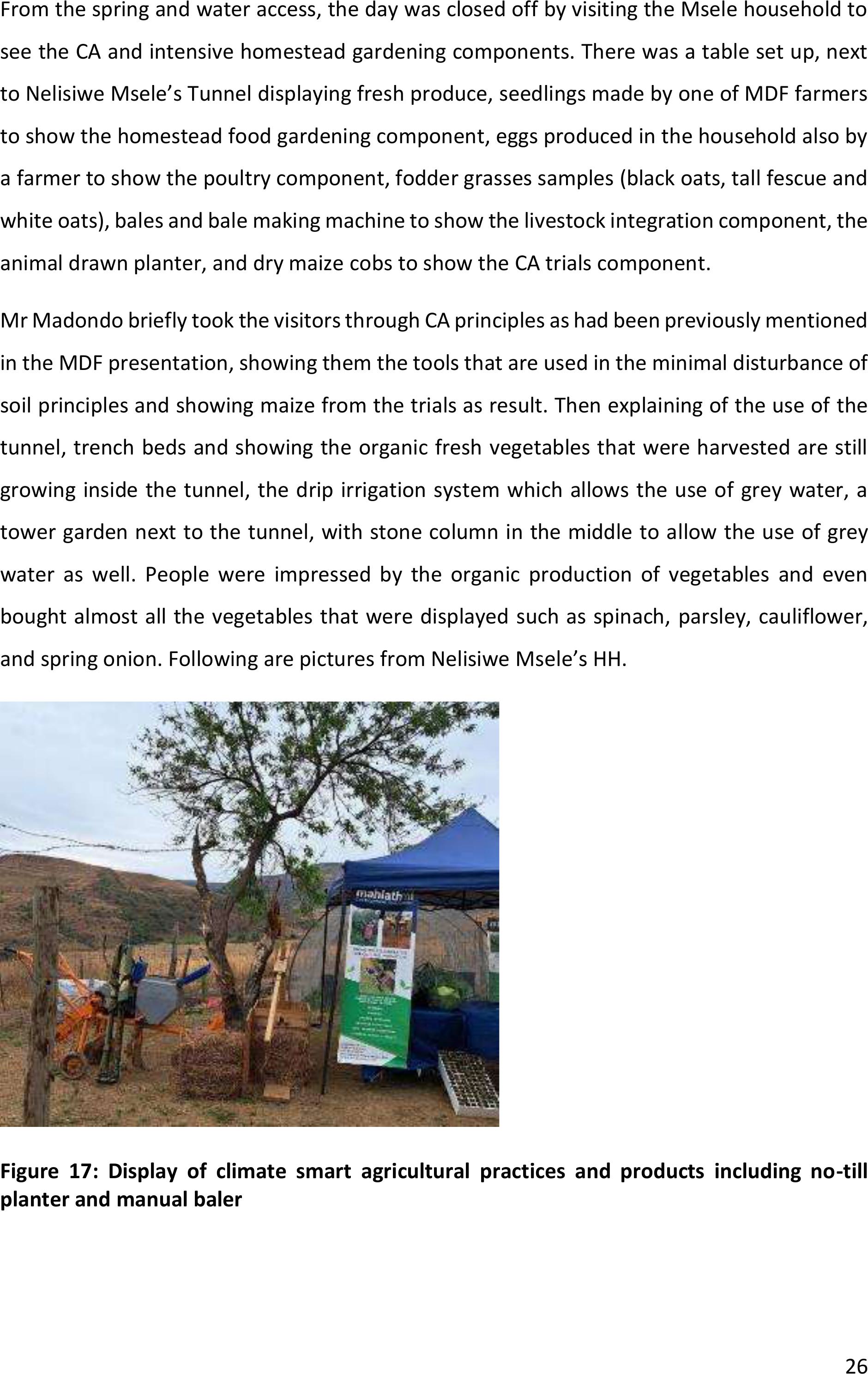
From the spring and water access, the day was closed off by visiting the Msele household to
see the CA and intensive homestead gardening components. There was a table set up, next
to Nelisiwe Msele’s Tunnel displaying fresh produce, seedlings made by one of MDF farmers
to show the homestead food gardening component, eggs produced in the household also by
a farmer to show the poultry component, fodder grasses samples (black oats, tall fescue and
white oats), bales and balemaking machine to show the livestock integration component, the
animal drawn planter, and dry maize cobs to show the CA trials component.
Mr Madondo briefly took the visitors through CA principles as had been previously mentioned
in the MDF presentation, showing them the tools that are used in the minimal disturbance of
soil principles and showing maize from the trials as result. Then explaining of the use of the
tunnel, trench beds and showing the organic fresh vegetables that were harvested are still
growing inside the tunnel, the drip irrigation system which allows the use of grey water, a
tower garden next to the tunnel, with stone column in themiddle to allow the use of grey
water as well. People were impressed by the organic production of vegetables and even
bought almost all the vegetables that were displayed such as spinach, parsley, cauliflower,
and spring onion. Following are pictures from Nelisiwe Msele’s HH.
Figure 17: Display of climate smart agricultural practices and products including no-till
planter and manual baler
27
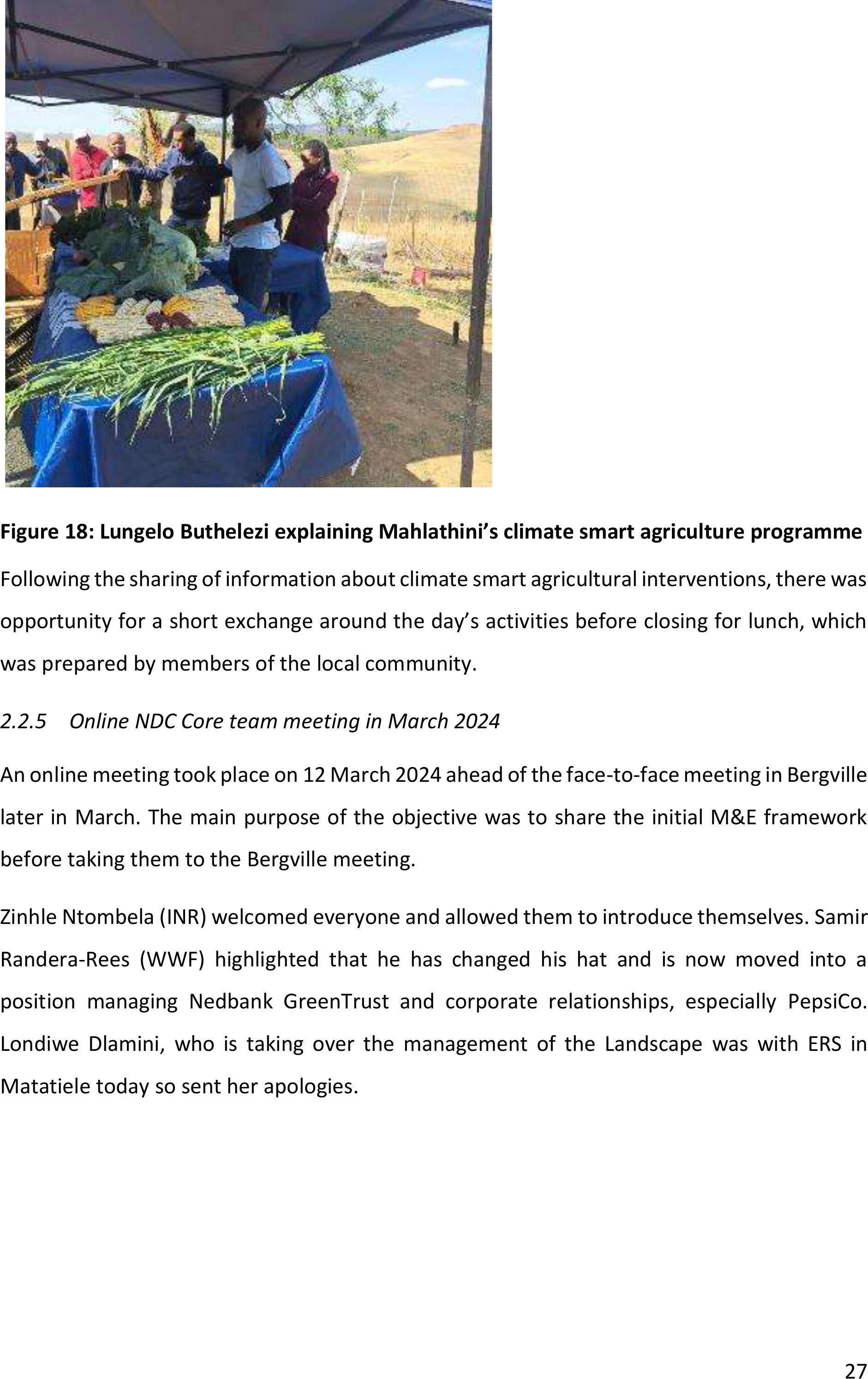
Figure 18: Lungelo Buthelezi explaining Mahlathini’s climate smart agriculture programme
Following the sharing of information about climate smart agricultural interventions, there was
opportunity fora short exchange around the day’s activities before closing for lunch, which
was prepared by members of the local community.
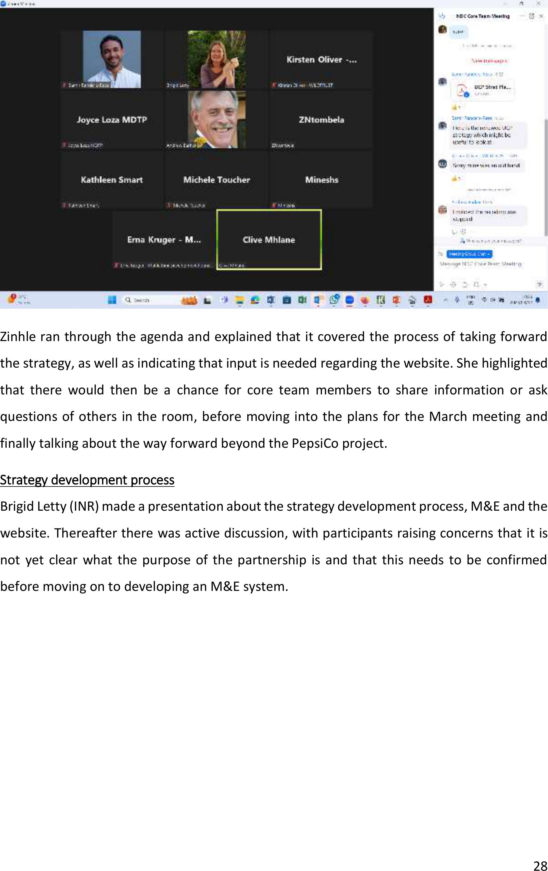
2.2.5Online NDC Core team meeting in March 2024
An online meeting took place on 12March 2024 aheadof the face-to-face meeting in Bergville
later in March. The main purpose of the objective was to share the initial M&E framework
before taking them to the Bergville meeting.
Zinhle Ntombela (INR) welcomed everyone and allowed them to introduce themselves. Samir
Randera-Rees (WWF) highlighted that he has changed his hat and is now moved into a
position managing Nedbank GreenTrust and corporate relationships, especially PepsiCo.
Londiwe Dlamini, who is taking over the management of the Landscape was with ERS in
Matatiele today so sent her apologies.
28
Zinhle ran through the agenda and explained that it covered the process oftaking forward
the strategy, as well as indicating that input is needed regarding the website. She highlighted
that there would then be a chance for core team members to share information or ask
questions of others in the room, before moving into the plans for the March meeting and
finally talking about the way forward beyond the PepsiCo project.
Strategy development process
Brigid Letty (INR) made apresentation about the strategy development process, M&E and the
website. Thereafter there was active discussion, with participants raising concerns that it is
not yet clear what the purpose of the partnership is and that this needs to be confirmed
before moving on to developing an M&E system.
29
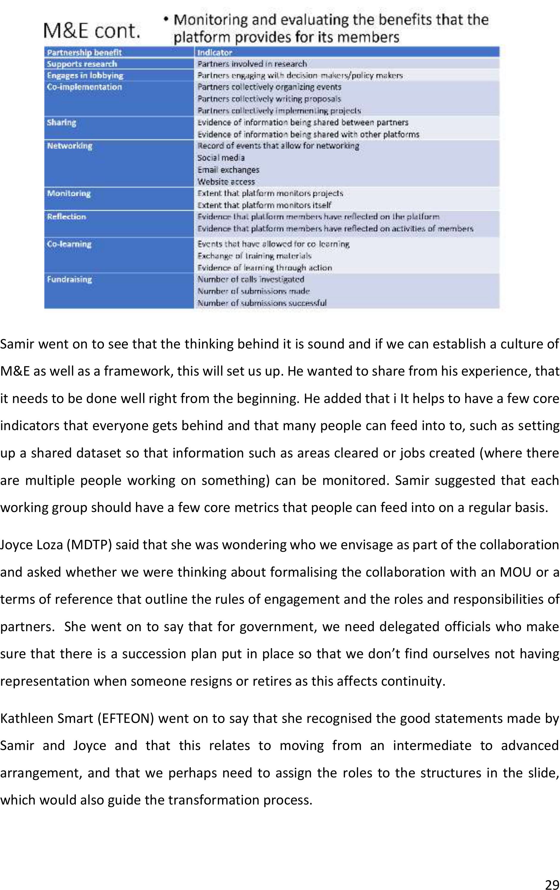
Samir went on to see that thethinking behind it is sound and if we can establish a culture of
M&E as well as a framework, this will set us up. He wanted to share from his experience, that
it needs to be done well right from the beginning. He added that i It helps to have a few core
indicators that everyone gets behind and that many people can feed into to, such as setting
up a shared dataset so thatinformation such as areas cleared or jobs created (where there
are multiple people working on something) can be monitored. Samir suggested that each
working group should have a few core metrics that people can feed into on a regular basis.
Joyce Loza (MDTP) said that she was wondering who we envisage as part of the collaboration
and asked whether we were thinking about formalising the collaborationwith an MOU or a
terms of reference that outline the rules of engagement and the roles and responsibilities of
partners. She went on to say that for government, we need delegated officials who make
sure that there is a succession plan put in place so that we don’t find ourselves not having
representation when someone resigns or retires as this affects continuity.
Kathleen Smart (EFTEON) went on to say that she recognised the good statements made by
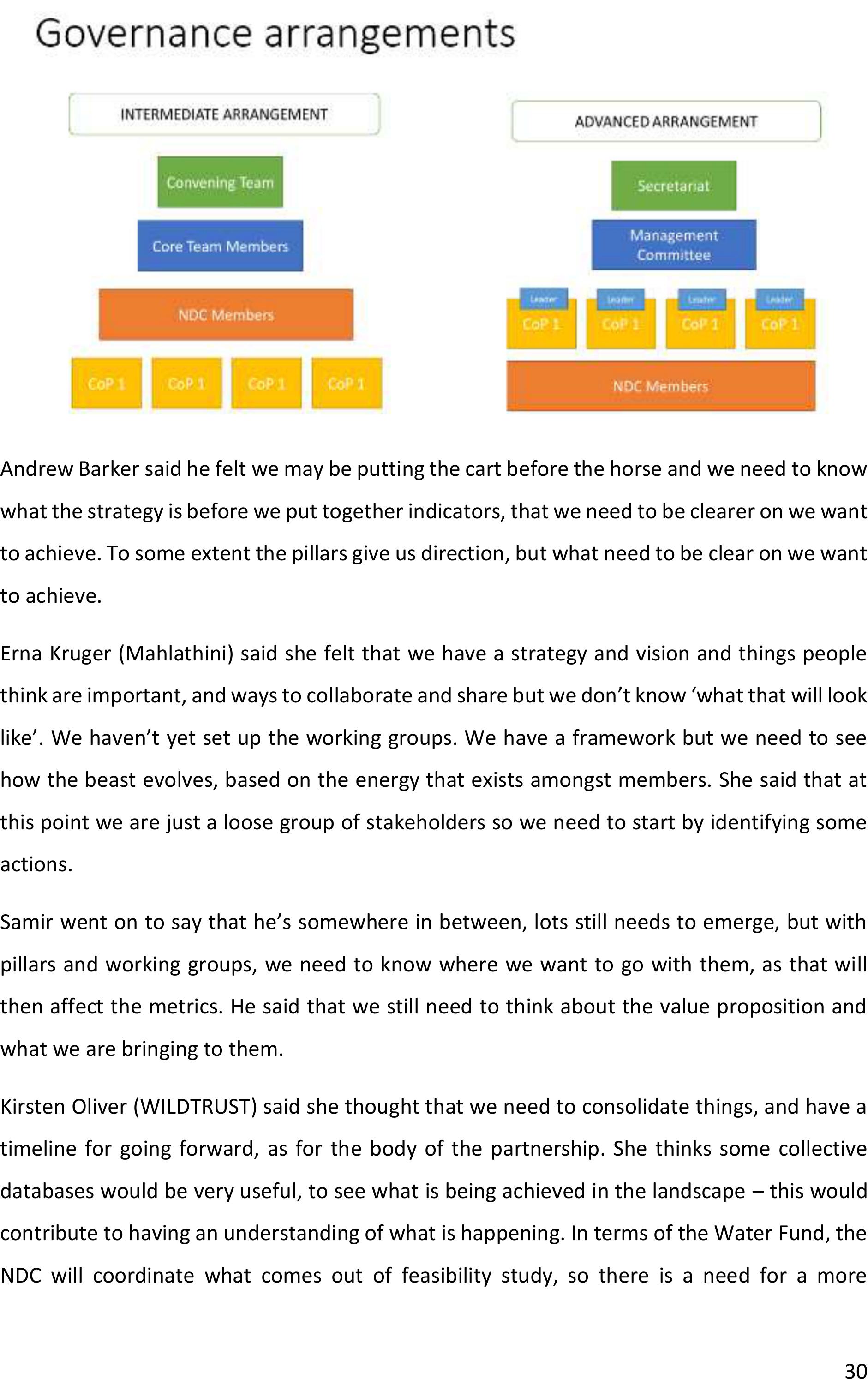
Samir and Joyce and that this relates to moving from an intermediate to advanced
arrangement, and that we perhaps need to assign theroles to the structures in the slide,
which would also guide the transformation process.
30
Andrew Barker said he felt we may be putting the cartbefore the horse and we need to know
what the strategy is before we put together indicators, that we need to be clearer on we want
to achieve. To some extent the pillars give us direction, but what need to be clear on we want
to achieve.
Erna Kruger (Mahlathini) said she felt that we have a strategy and vision and things people
think are important, and ways to collaborate and share but we don’t know ‘what that will look
like’. We haven’t yet set up the working groups. We have a framework but we need to see
how the beast evolves, based onthe energy that exists amongst members. She said that at
this point we are just a loose group of stakeholders so we need to start by identifying some
actions.
Samir went on to say that he’s somewhere inbetween, lots still needs toemerge, but with
pillars and working groups, weneed to know where wewant to go with them, as that will
then affect the metrics. He said that we still need to think about the value proposition and
what we are bringing to them.
Kirsten Oliver (WILDTRUST) said she thought that we need to consolidate things, and have a
timeline for going forward, as for the body of the partnership. She thinks some collective
databases would be very useful, to see what is being achieved in the landscape –this would
contribute to having an understanding of what is happening. In terms of the Water Fund, the
NDC will coordinate what comes out of feasibility study, so there isa need for amore
31
structured format for this partnership. It needs to be more formalised, rather than just coming
together when invited for a meeting.
Reflecting on the partnership pillars, and referring togovernance, Joyce said she felt there
was a need to confirm what people are doing –on an integrated map (which we did initiate
at a previous meeting in Bergville) –butthen to consider how we get that map integrated
into the IDP so we know what people are doing and that it’s getting political support and
recognition and informing planning documents such as spatial development frameworks.
Zinhle added that initially we kept itloose and we circulated commitment statements that we
asked people to sign. But now, as we need to transition, we need more commitment from the
partners to make sure it moves forward. She said that as the strategic group, perhaps we need
to not let it sit until the meeting on the 20thand present some thoughts there.
Joyce said that we need knowledge development –need to monitor learning exchanges and
learning exchanges conducted, and ensuring there are mechanisms in place for knowledge
management – perhaps a data hub on the website.
Andrew responded to Joyce’s comments about IDP saying that we definitely need to have
political recognition. He suggested that we ask Samir in terms of other SWSAs about how this
is being achieved –can we learn from them? He also went on to say that if we need
commitment, then its commitment for what? He needs to be able to present this to
constituencies and be able to list specific activities that they need to participate in. What will
we share, how can we share? This needs to emerge from the strategy.
Samir shared the UCP strategy plan. He said that there is plenty to share and we can facilitate
co-learning but noted that while UCP is a great example, their M&E has not been strong
enough to demonstrate the impact of the partnership. Furthermore, the strategic plan from
UCP is 10 years into the partnership and ours is much earlier and needs to be much higher
level, without deep action plans and timelines, but it is useful to have a roadmap ofsome
sort.
32
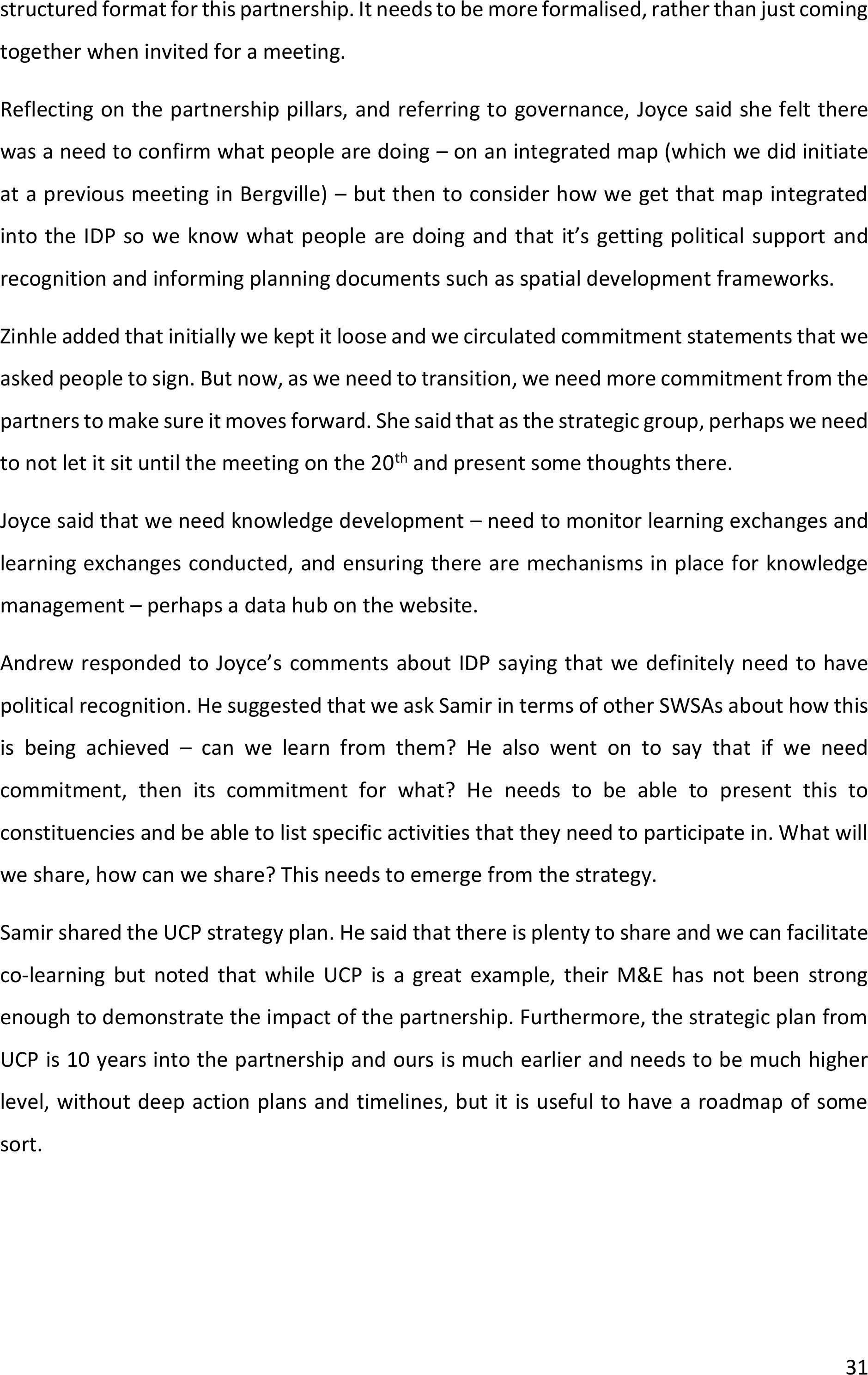
Figure 19: Diagram from the strategy document of the Umzimvubu Catchment Partnership.
Samir shared a diagram from the UCP strategy. He used it to explain that when we tell the
story of the partnership, we want to show that its leading to action on the ground and changes
in livelihoods, land, etc. This is what makes funders open their eyes.
Erna suggested that we collectively populate the slide with the partnership pillars in terms of
the activities and outcomes to give us something tangible to take forward. Samir said we need
to differentiate between the what and the how –foreach pillar. Need a concise description
and then say how to achieve it.
The following table provides a summary of what was proposed for each of the pillars.
Table 1: Inputs made during the online meeting regarding the partnership pillars
Pillar
Description
Governance &
strategy
JL: To strengthen integrated catchment management through collaboration
amongst partners (and monitor this ito of an integrated mapthat shows where
people are working, their areas of focus (measure whether areasare also
finding recognition in the IDPs and long term environmental management and
SD frameworks, and annual IDPs). The map should find expression in the IDP.
33
EK: internal governance of the partnership, also intervening in different levels
of governance within the catchment (Water management, agric, conservation
areas) –will feed into the CoPs. The partnership needs to be developing
strategies to improve governance in each of these areas – so partners need to
work together on these. Needs inputs into policy (CMFs, municipal thinking
groups, etc.)
SR: recognising that governance systems are not functioning well and the
partnership can help to strengthen them bu establishing a governance that can
assist mandated parties to solve governance issues in a collective manner.
Creating a united outlookfor the landscape that all parties can buyin to and
support and contribute towards.
Networking &
communication
JL: Education and awareness creation –combining resources that are
shrinking. Study tours for decision-makers – might lead to access to resources.
Networking - speaks to ones above and below- use other existing CoPs (ARU –
established a structure in 2022 – would allow for networking and sharing)
Interacting with UCP partners as part of networking
Networking with funders
EK: a central function of the partnership –to be led by the group that takes
over from the convener team.4
SR: different levels – facilitating it between partners to contribute to learning,
outwards –beyond the catchment to funders, government -tell the stories
from the catchment and garner support; then networking into the landscape
since not everyone can be at every meeting, so need to communite to
communitysx, TAs, land owners, etc
networking transboudary
Learning &
sharing
NEED TO
INCLUDE
RESEARCH
MORE
EXPLICITLY
Records of learning exchanges, knowledge development, knowledge exchange
(how many for the year). Updating of existing website with knowledge that has
been developed or shared by role-players.
EK: on differentlevels –local, facilitated through the collaboration on different
themes; regional sharing between different stakeholders in region andthen
national sharing to introduce new ideas into the system.
SR: Facilitating learning to allow people to do things better and achieve more
impact.
Sharing –talks to communications and M&E. sharing resources and
information and our knowledge facilitates learning and implementation.
34
Need to recognize that we want to set a research agenda for the catchment
that everyone can feed into, to avoid extractive research, built for purpose,
that contributes to the vision for the landscape.
Action,
implementation
& feedback
EK: Map of stakeholders and projects –need a process for updating it and
keeping people in the loop with that. A platform that says these are things that
should be happening – who has the energy to take forward.
Within collaboration - have sessions around specific topics and see how they
interact with other themes.
SR: about identifying the needs, threats from the landscape and designing
solutions that respond and solve them. Harnessing collective power and skills
from the partnership –recognizing that together we can do more and do it
better.
Resourcing
EK: Fundraising, own effort, what partnerships are willing to bring at any point.
Need more specific inputs (next steps)
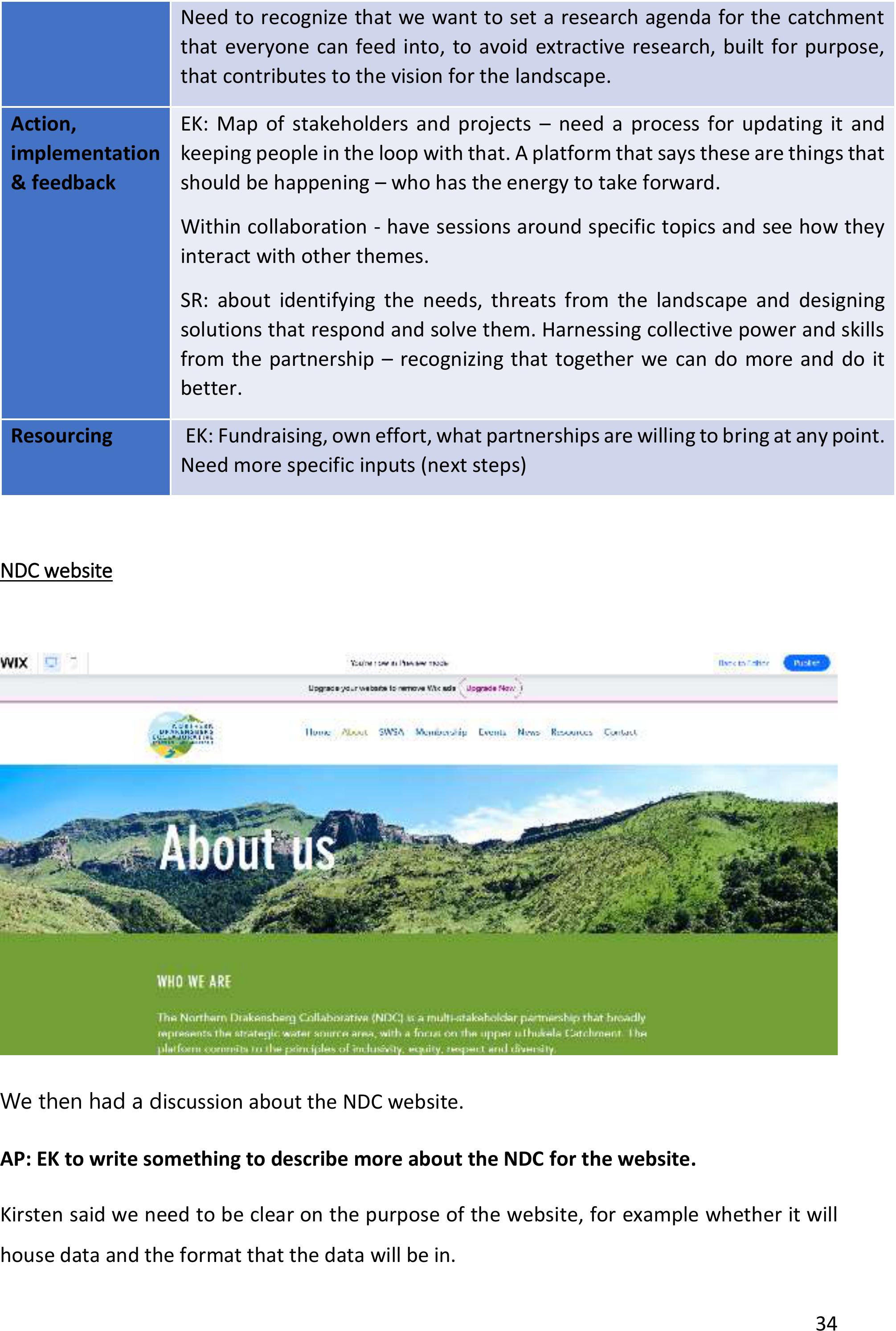
NDC website
We then had a discussion about the NDC website.
AP: EK to write something to describe more about the NDC for the website.
Kirsten said we need to be clear on the purpose ofthe website, for example whether it will
house data and the format that the data will be in.
35
There was discussion about possible names for the website domain. Options that were
proposed were:
•Northerndrakcollab (.com or .co.za or .org)
•NorthernDrakensbergCollaborative
•NorDraCol - keep it short as it becomes an email address and you don’t want it too lo
ng
and go for ‘org.za’
•NDrakCollab
Questions were raised about the future. Clive Mhlane (DWS) asked who the admin would be
moving forwards and Kirsten asked who would continue paying for the domain. Brigid
highlighted that these would be discussed during the later session in the agenda.
Prep for March20th
There was discussion about the plans for the meeting in Bergville.
BL to circulate revised slides to core team ahead of the 20th event to get final input (AP: BL)
Way forward beyond PepsiCo
The main points to be discussed were:
•An event in June beyond the PepsiCo project timeframe.
•Website maintenance and associated costs.
Kathleen asked for clarity regarding the purpose ofthe June meeting. ZN saidthat since we
won’t exhaust the partnership strategy discussion on the 20thperhaps June will allow us to
continue the discussion and keep the momentum going. She asked what funding is required
going forward on a yearly basis, not just for holding the June event.
Zinhle added that the coordination role came up in discussion with Londi, but it was not clear
who will coordinate events, remind people, report on activities, etc. This coordinating person
needs to work closely with Londi. Kathleen asked whether our vision is to have a funded,
dedicated coordinator and whether partners need to fund them. Brigid highlighted that while
there isno funded project we need to decentralise roles and not assume one organisation
can cover everything. Michele Toucher (SAEON) asked for some time to come back to us with
what people think they contribute.
36
Joyce suggested that we document the coordination responsibilities and circulate prior to the
meeting on the 20thso that people can then identify where they fit in and volunteer for
specific roles.
AP BL to prepare the summary ahead of the 20th.
Kathleen said that if we go eventby event, the volunteering of resources can be passed
around for an event or two, alternatively we try to have an approach that allowsfor
continuity. She questioned whether EFTEON’s financial contribution might be better spent on
having a coordinator than on catering for an event.
Erna went on to say that there is a high likelihood of getting funding in the longer term, so for
now let’s just see this as a short term stopgap. She referred to the Lewis proposal as one
possible source of funding.
Closure
Zinhle ended saying weneed to make some space for this discussion in the meeting at
Bergville the following week.
2.2.6Meeting in Bergville in March 2024
This meeting that was held in the BergvilleSports Centre Boardroom had the following
agenda, which allowedfor sharing of information by members while allowing for discussion
about the NDC strategy as well as the way forward beyond the PepsiCo project.
1.Welcome and introductions – Zinhle (30 min)
2.Draft strategy and website for discussion – Brigid (60 min) 10h00-11h00
3.Updates on any ongoing initiatives: 11h00 – 13h00
a.Liam Cogill (MAPWAPS) 20 min
b.Pearl Gola (SANBI) 20 min
c.Sipho Ndaba (Cannabis project) 20 min
d.Minesh Sookamdev (DFFE herbicide programme) 20 min
e.Kirsten Oliver (The Water Fund) 20 min
f.Lucas van der Vijver (Research) 20 min
Lunch 13h00-14h00
4.Way forward beyond WWF PepsiCo project 14h00-15h00
5.Closure – Zinhle (10 min) 15h00-15h15
37
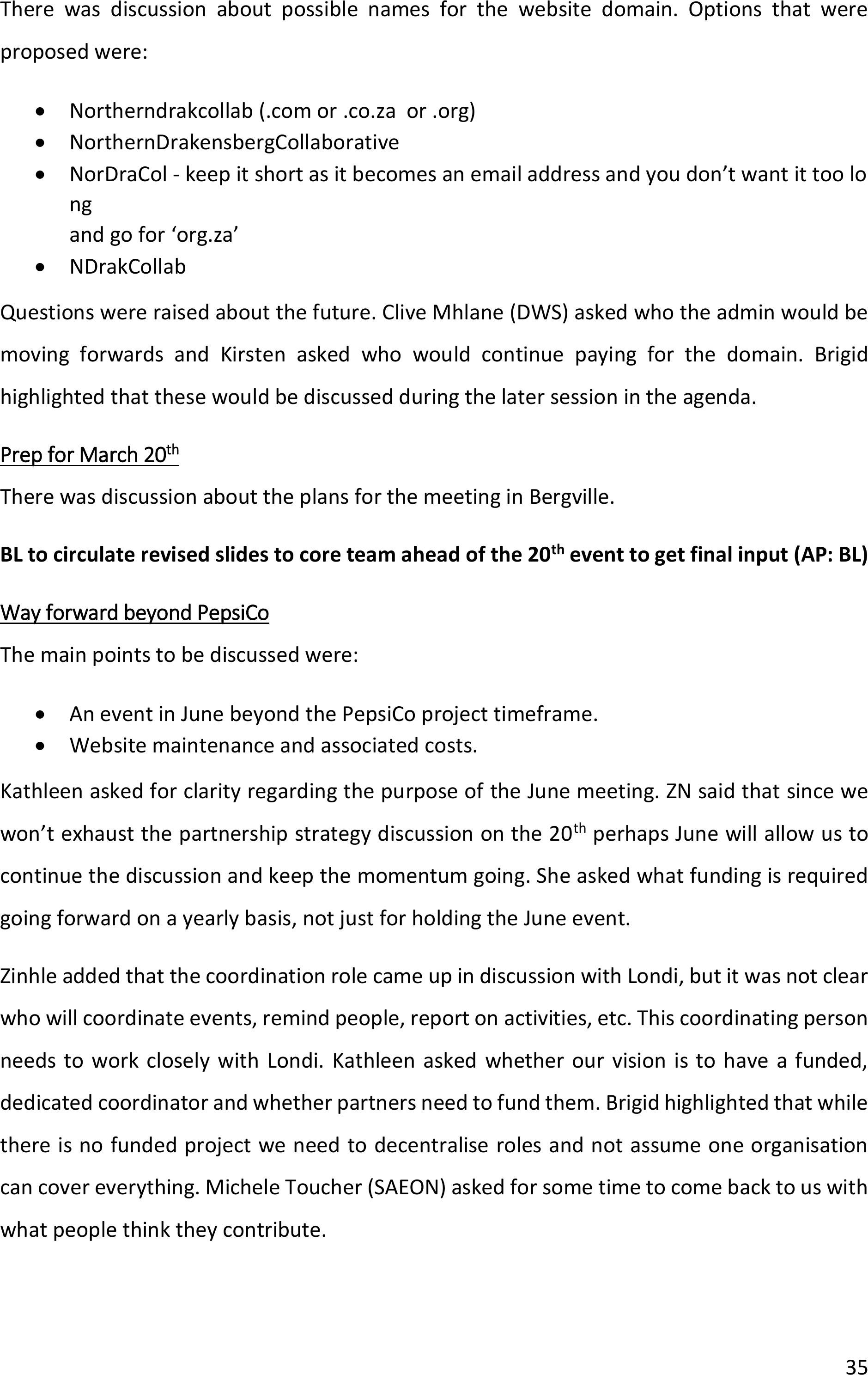
The programme was very full, but there were substantial discussions between participants
over lunch at the end of the day. Some key outcomes of the meeting were that EFTEON and
WWF committed to supporting the event in June 2024. There was agreement amongst
participants (indicated on the attendance register) to share emails and mobile phone
numbers to enhance sharing and networking. The suggestion was that we should have
Whatsapp subgroups that allow for development of action plans for working groups/CoPs.
One of the representatives of traditional authorities that attended themeeting requested a
space in the June programme to share input about activities that they would like to undertake
and for which they need support.
There was a suggestion for a specificCoP on water access and a discussion around the
implications of changes in policies of DWS. Clive Mhlane (DWS) highlighted that there was a
consultation process around changes to legislation. Pearl Gola (SANBI) askedthat the NDC
members be informed about other policy documents that are being prepared or revised.
It was evident that a system needs to be in place to allow for stakeholders to update the maps
that show where different organisations are active.
There was much discussion about communities accessing herbicide from DFFE via Minesh.
Since it needs a coordinator that can commit to ensuring that the chemicals are handled
safely, there is a need to organize people in order to be able to operationalize this.
Commitment statements were circulated and a number were signed at the event and
returned to the convener team.
38
Figure 20: Sharing of information by partners at the workshop inBergville on 20March
2024.
2.3Situation assessment, stakeholder mapping and analysis
2.3.1Situation assessment
A report was drafted and circulated to the core team members for inputs. It was revisedbased
on the inputs received.
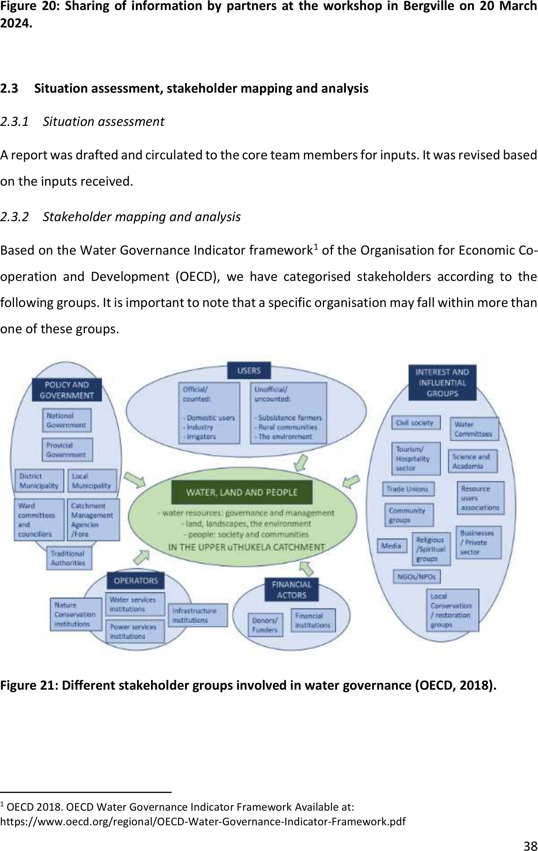
2.3.2Stakeholder mapping and analysis
Based on the Water Governance Indicator framework
1
of the Organisation for Economic Co-
operation and Development (OECD), we have categorised stakeholders according to the
following groups. It is important to note that a specific organisation may fall within more than
one of these groups.
Figure 21: Different stakeholder groups involved in water governance (OECD, 2018).
1
OECD 2018. OECD Water Governance Indicator FrameworkAvailable at:
https://www.oecd.org/regional/OECD-Water-Governance-Indicator-Framework.pdf
39
Stakeholder participation
Over the series of workshops that took place over the 2021-2022 period, prior to the PepsiCo
funded project, more than 100 stakeholders representing more than 60 organisations have
been represented and this number expanded during the 2023-2024 period, especially due to
the expansion of the geographic area to include the broader Northern Drakensberg SWSA.
Participants have comefrom the following categoriespolicy and government, operators,
financial actors, interest and influential groups and users.
The stakeholder engagement process led to a common vision and relevant activities as shown
in Figure 3.
40
Figure 22: Detail of stakeholders as representing different stakeholder groups in the Northern Drakensberg SWSA.

41
Figure 23: Outcomes of the stakeholder engagement process.

42
Survey about a survey of catchment members
In September – October 2022 an online survey was sent to a sub-group of the participants to
scope stakeholders’ roles, activities in the catchment, and their expectations of a catchment
partnership in the upper uThukela. To thequestion “What do you think the Upper uThukela
Catchment Partnership should do?”15 respondents provided a range of suggestions relating
to collaboration, coordination, networking, facilitate communication, data and knowledge
exchange, co-learning and information dissemination, coordinate research and monitoring,
coordinate and co-implement projects, interventions and job creations (Figure 3).
Figure 24: Survey responses to the question “What do you think the Upper uThukela
Catchment Partnership should do?”
2.4Strategy development and creation of CoPs
2.4.1Strategy development process
The process of developing a strategy for the NDC was initiated by the convening team butwas
further built through discussions that took place at various meetings and workshops as
described above.

43
2.4.2Draft NDC strategy
Background:
The Northern Drakensberg Collaborative (NDC) is a multi-stakeholder partnership that
broadly represents the strategic water source area, with a focus on the upper uThukela
Catchment. The platform commits to the principles of inclusivity, equity, respect and
diversity.
This process of establishing the partnership was initiated through the Living Catchments
Project (LCP) of the South African National Biodiversity Institute (SANBI), and has been
continued through an initiative championed by WWF. A coordinating team comprising the
Institute of Natural Resources NPC (INR), Mahlathini Development Foundation (MDF) and the
Centre for Water Resources Research (CWRR) at University of KwaZulu-Natal, has led the
process of operationalising and sustaining the partnership.
Vision:
Collaboration among different entities to conserve and sustainably utilize the landscape and
its water, cultural and other natural resources fairly as well as to empower its people, build
resilience and achieve sustainable socio-economic growth.
Partnership principles:
There are a number of principles that underpin and guide the NDC, namely
•Inclusivity: The operation of the NDC and its activities will be designed to allow for the
inclusion of all member groups.
•Equity: The structures of the NDC will represent all member groups.
•Respect: Members will respect the views of others.
•Diversity: The NDC recognizes different races, genders, religions and is apolitical.
Value proposition:
As shown in the figure below, the NDC provides arange of benefits for its members while also
requiring certain inputs from them.
The benefits of the partnership for its members can be summarized as follows:
•Networking: Providing a platform for different stakeholders to engage and exchange.
•Monitoring: A vehicle for monitoring the implementation of activities.
•Co-learning: A mechanism for co-learning between stakeholders within and beyond.
•Fundraising: Stakeholders can work collectively to raise funds.

44
•Sharing: The platform allows for sharing of information through different channels.
•Co-implementation: Members can implement activities collectively.
•Lobbying: The platform provides a voice for its members.
•Supporting research: The platform can support research and share research
outcomes.
The inputs required from its members can be summarized as:
•Participate: Members need to participate in meetings, events and discussions.
•Resource: Members need to be willing to provide resources of different types.
•Share: Members need to be open to sharing information and experiences.
•Commit: Members need to commit to the partnership.
•Collaborate: Members need to be willing to collaborate around activities.
Figure 25: Diagram showing key elements of the Northern Drakensberg Collaborative.
The NDC will provide the benefits to its members through the following:
•A stakeholder database.
•Collaborative working groups.
•A website and newsletter.
•Co-opting multiple stakeholders.
45
Partnership pillars:
The NDC relies on five partnership pillars:
1.Governance and strategy
2.Networking & communication
3.Learning & sharing
4.Action, implementation & feedback
5.Resourcing
The expected outcomes for each of the pillars, together with activities required to achieve
the outcomes are summarized below in Table 2.
Table 2: Summary ofoutcomes and activities associated with each of the NDC partnership
pillars
Pillar
Outcome
Activities
Governance
and strategy
•Internal: Effective
governance of the NDC
partnership
•External: Effective
governance within the
SWSA; integrated catchment
management
•Establish a secretariat for the
NDC and CoP theme leaders to
drive action.
•Monitor the effectiveness of
the partnership and the
impacts on the ground
•Engage LM about alignment
with IDP
Networking &
communication
•Internal –Enhanced sharing
between partners
•External –Enhanced
communication with
partners beyond the
catchment
•Enhance sharing over email
and website
•NDC members to participate in
other forums to network
information
Research,
learning and
sharing
•Sharing of information and
knowledge leads to
enhanced impact
•A shared research agenda
for the catchment
•Make reports and guidelines
available on the website
•Establish a research task team
to drive an agenda
Action,
implementation
& feedback
•Solutions to address
challenges are co-
developed, tested and
assessed
•Update map of partner
activities
•Develop a joint database for
action
46
Resourcing
•Partnership resourced for
good governance, to
network, learn, share and
implement
•Find ways to resource NDC
activities when no funded
convener team
•Fundraise for partnership
•Fundraise for action
Membership:
Membership of NDC is open to all organisations with a presence in the Northern Drakensberg
Strategic Water Source Area (SWSA)that work/operate in the water-livelihoods-biodiversity
space. This includes community structures and Traditional Authorities. Signing of the
commitment statement is the first step in the membership process.
Member activities:
Member activities
Communities
Private
sector
Officials
NGOs
Engage in lobbying activities to drive shared
agendas.
Co-implement projects that meets shared
objectives.
Collective raise funds for activities by co-
developing concept notes and proposals.
Implement projects that provide jobs, improve
livelihoods and eradicate poverty.
Promote sustainable land management
practices related to grazing, restoration,
clearing of alien invasive species.
Contribute resources that can support
landscape management activities
Invest in the catchment to contribute to
companies’ sustainability targets.
Local businesses can create opportunities for
communities (e.g. tourism)
Utilise onatural resources sustainably.
Collaborate to strengthen governance
arrangements for better natural resource
management in communal areas
Co-develop solutions to address issues that
affect communities.
Share knowledge and create awareness about
the NDC and its members.
47
Share research findings with other members
and translate research outcomes into action.
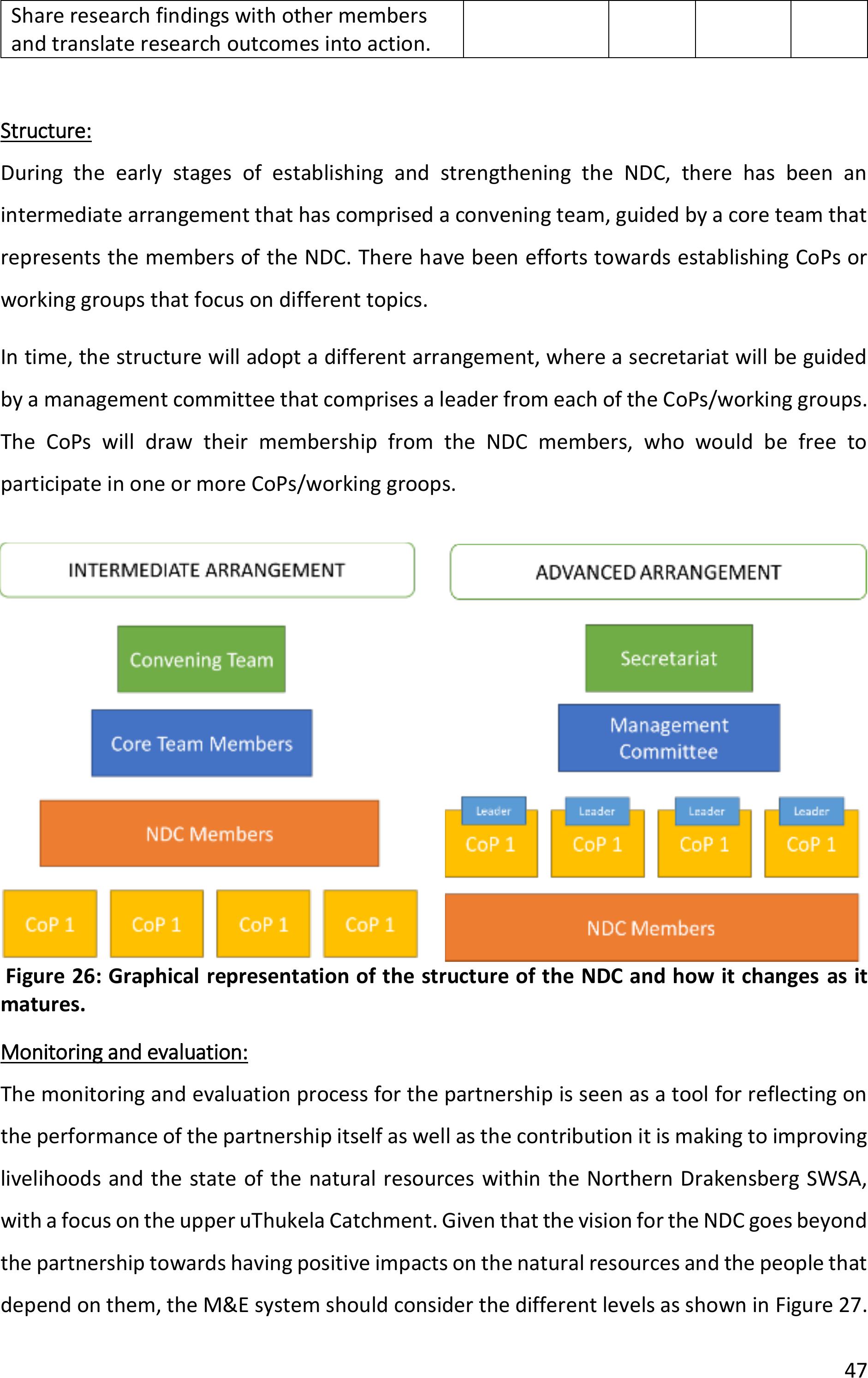
Structure:
During the early stages of establishing and strengthening the NDC, there has been an
intermediate arrangement that has comprised a convening team, guided by a core team that
represents the members of the NDC. There have been efforts towards establishing CoPs or
working groups that focus on different topics.
In time, the structure will adopt a different arrangement, where a secretariat will be guided
by a management committee that comprises a leader from each of the CoPs/working groups.
The CoPs will draw their membership from the NDC members, who would be free to
participate in one or more CoPs/working groops.
Figure 26: Graphical representation of the structure of the NDC and how it changes as it
matures.
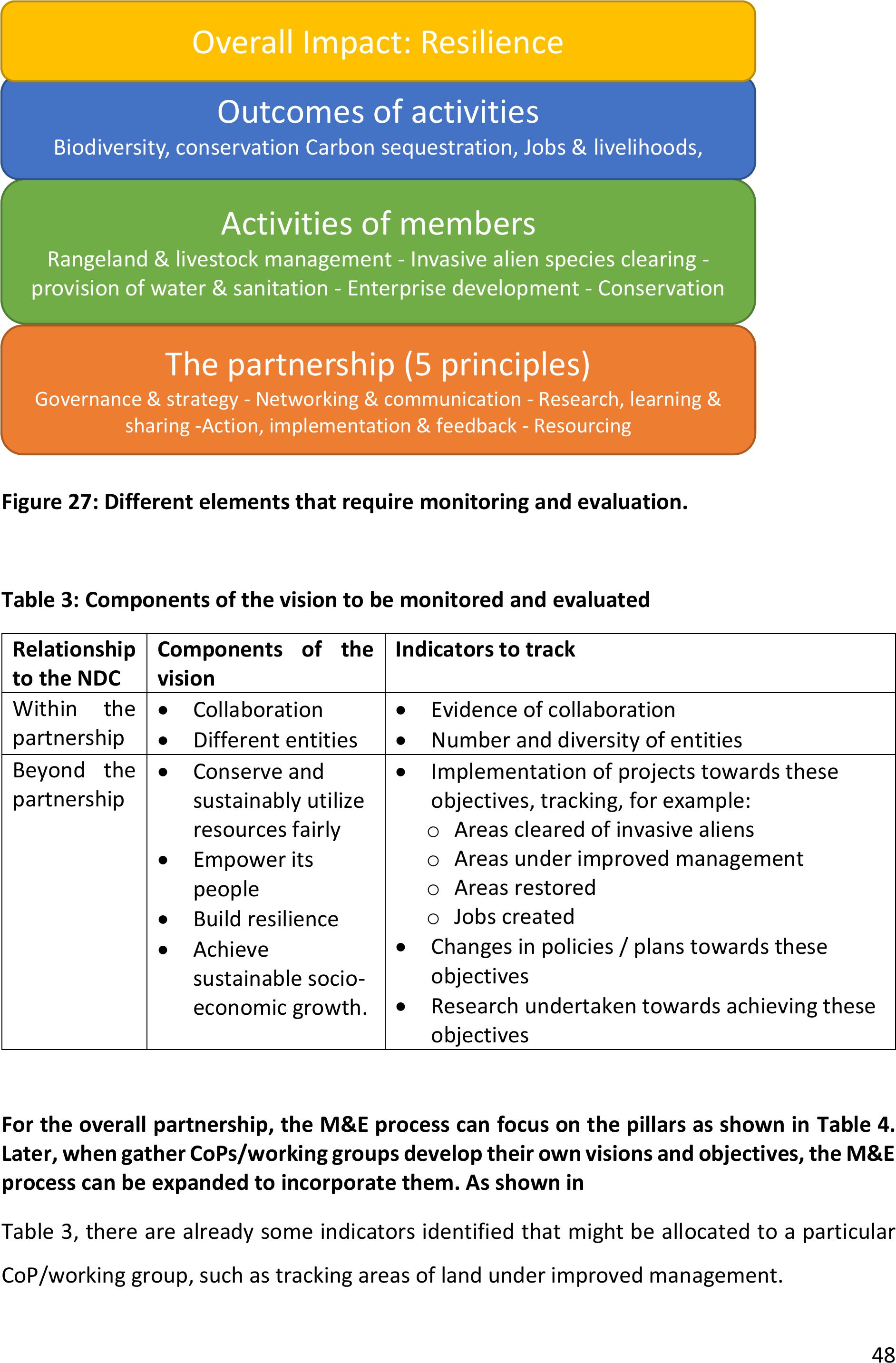
Monitoring and evaluation:
The monitoring and evaluation process for the partnership is seen as a tool for reflecting on
the performance of the partnership itself as well as the contribution it is making to improving
livelihoods and the state of the natural resources within the Northern Drakensberg SWSA,
with a focus on the upper uThukela Catchment. Given that the vision forthe NDC goes beyond
the partnership towards having positive impacts on the natural resources and the people that
depend on them, the M&E system should consider the different levels as shown in Figure 27.
48
Figure 27: Different elements that require monitoring and evaluation.
Table 3: Components of the vision to be monitored and evaluated
Relationship
to the NDC
Components of the
vision
Indicators to track
Within the
partnership
•Collaboration
•Different entities
•Evidence of collaboration
•Number and diversity of entities
Beyond the
partnership
•Conserve and
sustainably utilize
resources fairly
•Empower its
people
•Build resilience
•Achieve
sustainable socio-
economic growth.
•Implementation of projects towards these
objectives, tracking, for example:
oAreas cleared of invasive aliens
oAreas under improved management
oAreas restored
oJobs created
•Changes in policies / plans towards these
objectives
•Research undertaken towards achieving these
objectives
For the overall partnership, the M&E process can focuson the pillars as shown in Table 4.
Later, when gather CoPs/working groups develop their own visions and objectives, the M&E
process can be expanded to incorporate them. As shown in
Table 3, there are already some indicators identified that might be allocated to a particular
CoP/working group, such as tracking areas of land under improved management.
Activities of members
Rangeland & livestock management - Invasive alien species clearing -
provision of water & sanitation - Enterprise development - Conservation
Outcomes of activities
Biodiversity, conservation Carbon sequestration, Jobs & livelihoods,
Health & wellbeing, Water security
Overall Impact: Resilience
The partnership (5 principles)
Governance & strategy - Networking & communication - Research, learning &
sharing -Action, implementation & feedback - Resourcing
49
Table 4: Examples of indicators for monitoring anticipated outcomes for the partnership
pillars
Pillar
Anticipated outcomes
Indicators to track
Governance &
strategy
Internal: Effective governance of
the NDC partnership
External: Effective governance
within the SWSA; integrated
catchment management (ICM)
•Secretariat functioning well
•Strategy finalised
•Key stakeholders engaging in
the catchment towards
achieving ICM
Networking &
communication
Internal –Enhanced sharing
between partners
External –Enhanced
communication with partners
beyond the catchment
•Number of email exchanges
between partners
•Participation of NDC members
in activities of other
catchments
Research,
learning &
sharing
Sharing of information and
knowledge leads to enhanced
impact
A shared research agenda for the
catchment
•Number of events allowing for
sharing & learning.
•Number of events where
research outcomes shared.
Action,
implementation
& feedback
Solutions to address challenges
are co-developed, tested and
assessed
•No. of collaborative projects
implemented.
Resourcing
Partnership resourced for good
governance, to network, learn,
share and implement
•No. of concept notes/proposals
developed collectively.
•Contributions in time and
finances by members to
support partnership activities.
2.4.3Progress towards establishing communities of practice
Since the workshop at Alpine Heath in May 2023 did not provide sufficient time in the
programme to discusscommunities of practice, the link to a Google form was circulated by
email after the workshop to allow participants to providean indication of the themes that
were of interest to them (See Figure 28).
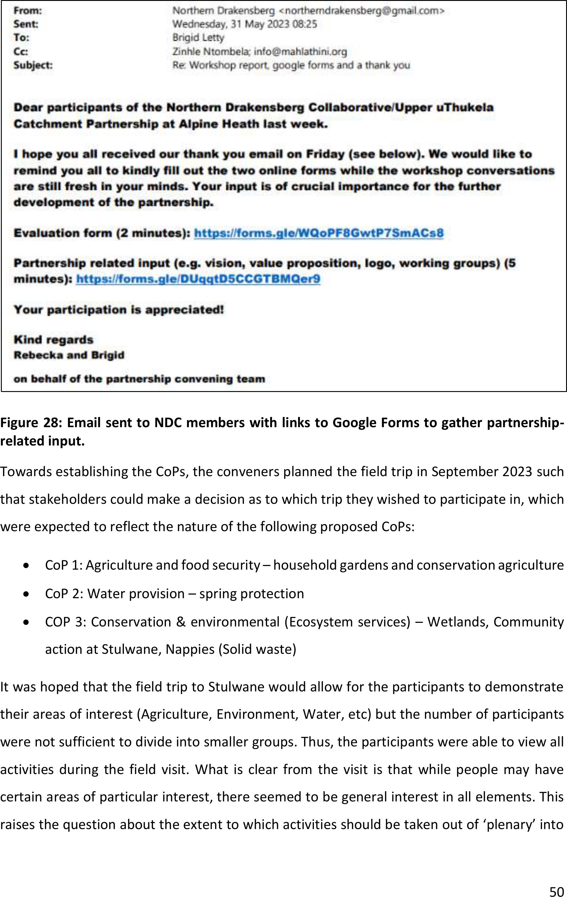
50
Figure 28: Email sent to NDC members with links to Google Forms to gather partnership-
related input.
Towards establishing the CoPs, the conveners planned the field trip in September 2023 such
that stakeholders could make a decision as to which trip they wished to participate in, which
were expected to reflect the nature of the following proposed CoPs:
•CoP 1: Agriculture and food security –household gardens and conservation agriculture
•CoP 2: Water provision – spring protection
•COP 3: Conservation & environmental (Ecosystem services) –Wetlands, Community
action at Stulwane, Nappies (Solid waste)
It was hoped that the field trip to Stulwane would allow for the participants to demonstrate
their areas of interest (Agriculture, Environment, Water, etc) but the number of participants
were not sufficient to divide into smaller groups. Thus, the participants were able to view all
activities during the field visit. What is clear from the visit is that while people may have
certain areas of particular interest, there seemed to be general interest in all elements. This
raises the question about the extent to which activities should be taken out of ‘plenary’ into
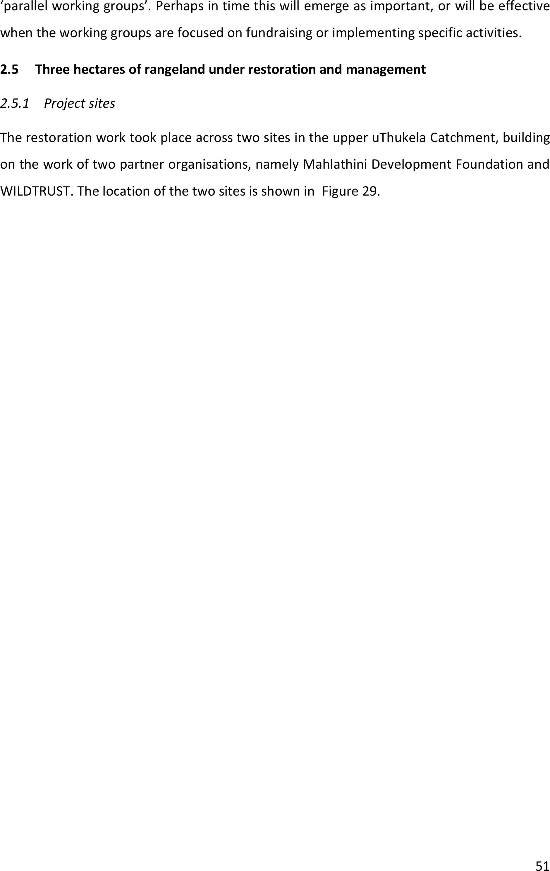
51
‘parallel workinggroups’. Perhaps in time this will emerge as important, or will be effective
when the working groups are focused on fundraising or implementing specific activities.
2.5Three hectares of rangeland under restoration and management
2.5.1Project sites
The restoration work took placeacross two sites inthe upper uThukela Catchment, building
on the work of two partner organisations, namely Mahlathini Development Foundation and
WILDTRUST. The location of the two sites is shown in Figure 29.
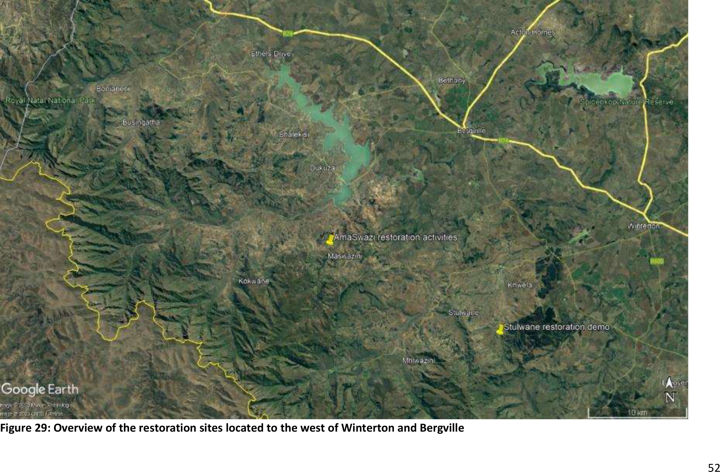
52
Figure 29: Overview of the restoration sites located to the west of Winterton and Bergville
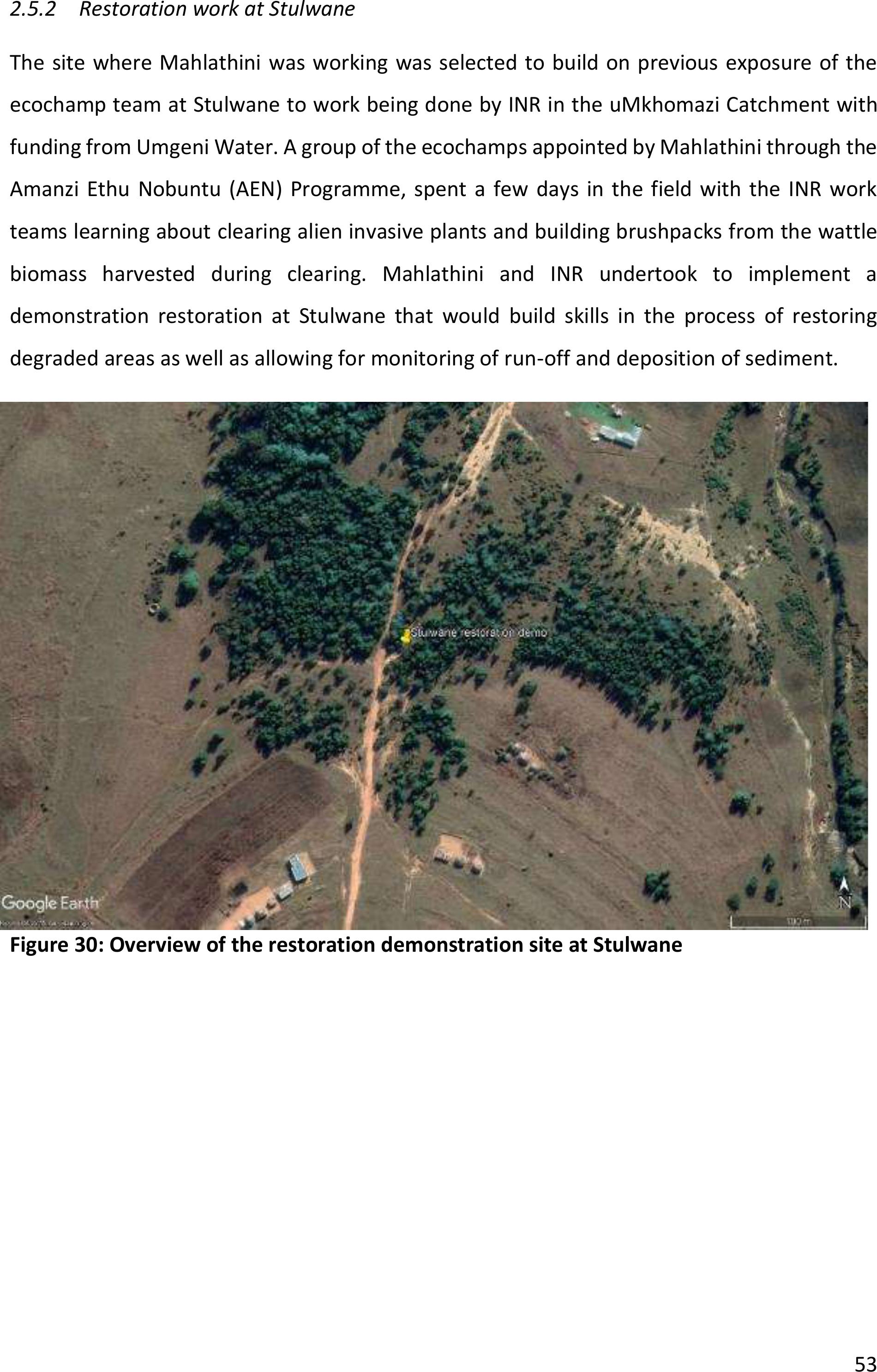
53
2.5.2Restoration work at Stulwane
The site where Mahlathini was working was selected to build on previous exposure of the
ecochamp team at Stulwane to workbeing done by INR in the uMkhomazi Catchment with
funding from Umgeni Water. A group of the ecochamps appointed by Mahlathini through the
Amanzi Ethu Nobuntu (AEN) Programme, spent a few days in the field with the INR work
teams learning about clearing alien invasive plants and building brushpacks from the wattle
biomass harvested during clearing. Mahlathini and INR undertook to implement a
demonstration restoration atStulwane that would build skills in the process of restoring
degraded areas as well as allowing for monitoring of run-off and deposition of sediment.
Figure 30: Overview of the restoration demonstration site at Stulwane
54
Project initiation
At this site, since the WWF PepsiCo project was supporting the continuation of the ecochamp
team that was previously employed through Amanzi ethu Nobuntu (AEN), there was no need
to recruit new team members. At the first trip, where the INR team was accompanied by field
staff from Mahlathini, a suitable site was identified that would allow for demonstration of
restoration techniques and measurement of impacts.
Figure 31: INR/Mahlathini team discussing possible demonstration sites at Stulwane with
the ecochamps.
A group of seven people were appointed for a 4-month period, with two of the group
members being retained onan ad hoc basis for the duration of the project for monitoring run-
off and sedimentation.
Ongoing implementation
The team at Stulwane, supervised by Mahlathini and with technical oversight provided by INR
continued with shaping the gulley, constructing brushpacks and revegetating the areas
between the brushpacks as well planting seed in the accumulated sediment.
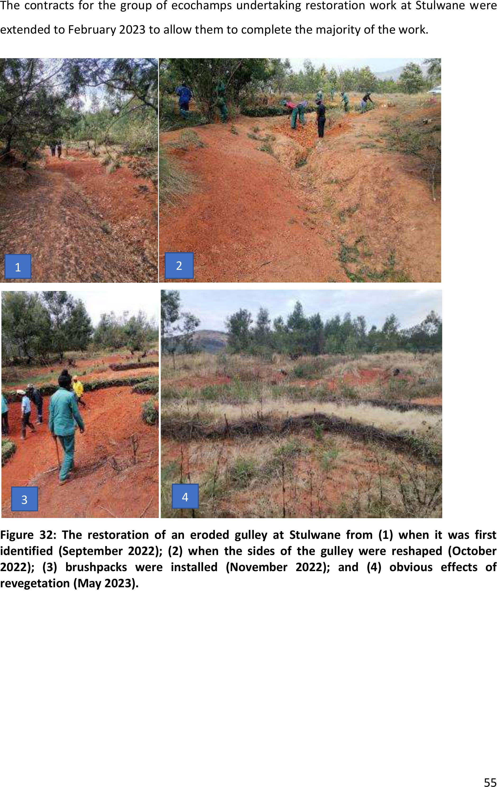
55
The contracts for the group of ecochamps undertaking restoration work at Stulwane were
extended to February 2023 to allow them to complete the majority of the work.
Figure 32: The restoration of an eroded gulley at Stulwane from (1) when it was first
identified (September 2022); (2) when the sides ofthe gulley were reshaped (October
2022); (3) brushpacks were installed (November 2022); and (4) obvious effects of
revegetation (May 2023).
1
2
3
4
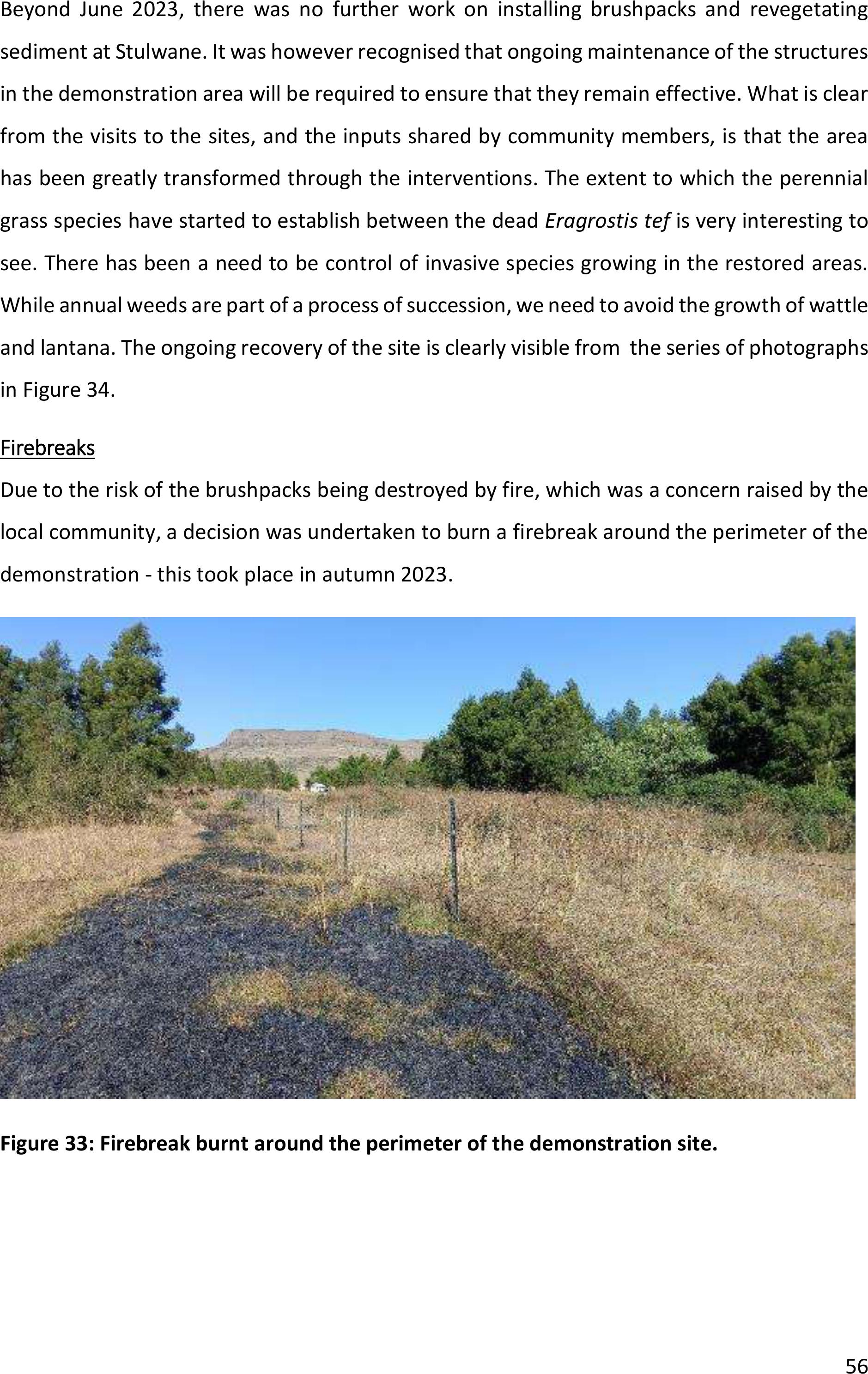
56
Beyond June 2023, there was no further work oninstalling brushpacks andrevegetating
sediment at Stulwane. It was however recognised that ongoing maintenance of the structures
in the demonstration area will be required to ensure that they remain effective. What is clear
from the visits to the sites, and the inputs shared by community members, is that the area
has been greatly transformed through the interventions. The extent to which the perennial
grass species have startedto establish between the dead Eragrostis tefis very interesting to
see. There has been a need to be control of invasive species growing inthe restored areas.
While annual weeds are part of a process of succession, we need to avoid the growth of wattle
and lantana. The ongoing recovery of the site is clearly visible from the series of photographs
in Figure 34.
Firebreaks
Due to the risk of the brushpacks being destroyed by fire, which was a concern raised by the
local community, a decision was undertaken to burn a firebreak around the perimeter of the
demonstration - this took place in autumn 2023.
Figure 33: Firebreak burnt around the perimeter of the demonstration site.

57
Figure 34: Overview of the demonstration site in September 2023 (top), December 2023
(middle) and February 2024 (bottom).

58
The google images clearly demonstratethe spread of wattle that has takenplace over time
and highlight the need to control it. The images also show that erosion takes place over very
extended time periods. A current image is not available but will show the resultsof the
restoration measures when it is published.
Figure 35: Stulwane restoration demonstration site (2009 image versus 2023 image).
December 2009
June 2023
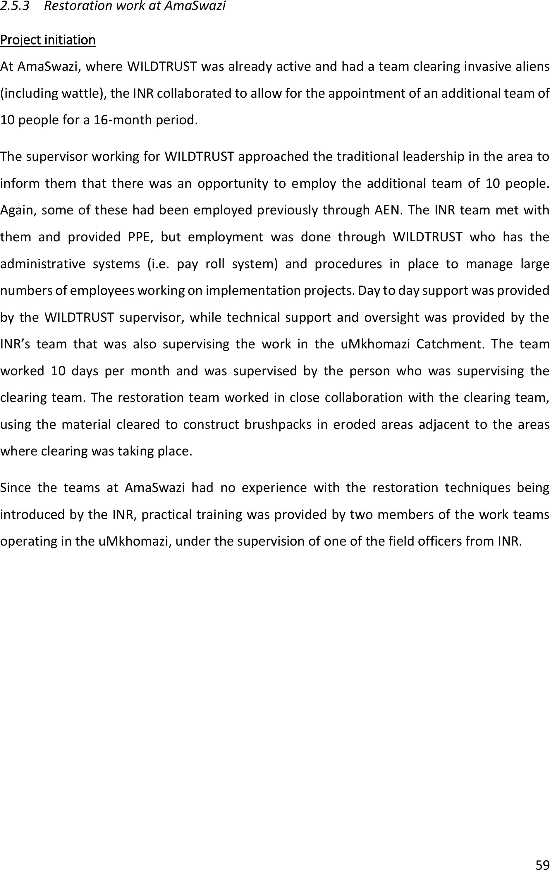
59
2.5.3Restoration work at AmaSwazi
Project initiation
At AmaSwazi, where WILDTRUST was already active and had a team clearing invasive aliens
(including wattle), the INR collaborated to allow for the appointment of an additional team of
10 people for a 16-month period.
The supervisor working for WILDTRUST approached the traditional leadership inthe area to
inform them that there was an opportunity to employ the additional team of 10 people.
Again, some of these had been employed previously through AEN. The INR team met with
them and provided PPE, but employment was done through WILDTRUST who has the
administrative systems (i.e. pay roll system) and procedures in place to manage large
numbers of employees working on implementation projects. Day to day support was provided
by the WILDTRUST supervisor, while technical support and oversight was provided by the
INR’s team that was also supervising the work inthe uMkhomazi Catchment. The team
worked 10 days per month and was supervised by the person who was supervising the
clearing team. The restoration team worked in close collaboration with the clearing team,
using the material cleared to construct brushpacks ineroded areas adjacent to the areas
where clearing was taking place.
Since the teams at AmaSwazi had no experience with the restoration techniques being
introduced by the INR, practical training was provided by two members of the work teams
operating in the uMkhomazi, under the supervision of one of the field officers from INR.
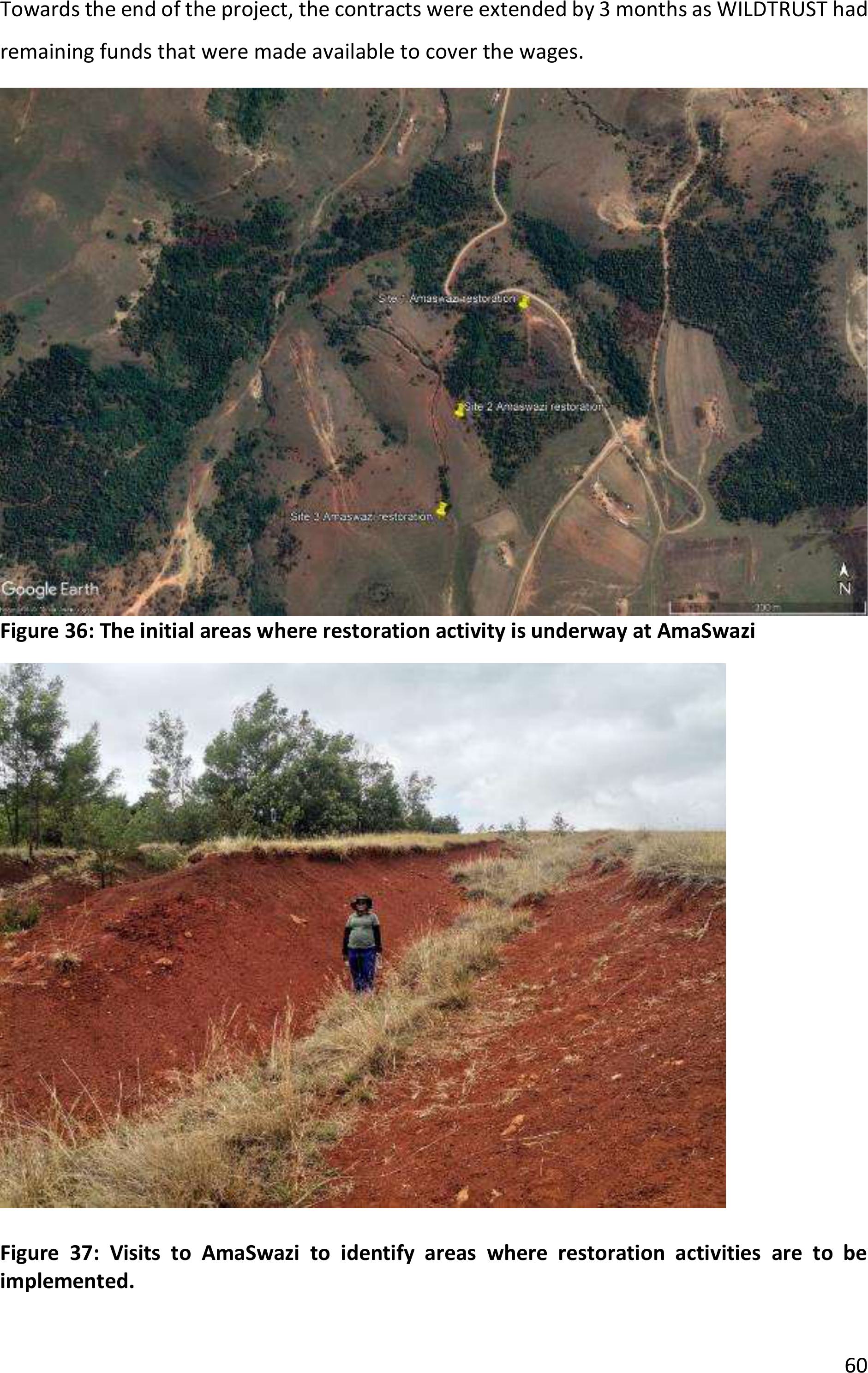
60
Towards the end of the project, the contracts were extended by 3 months as WILDTRUST had
remaining funds that were made available to cover the wages.
Figure 36: The initial areas where restoration activity is underway at AmaSwazi
Figure 37: Visits to AmaSwazi to identify areas where restoration activities are to be
implemented.
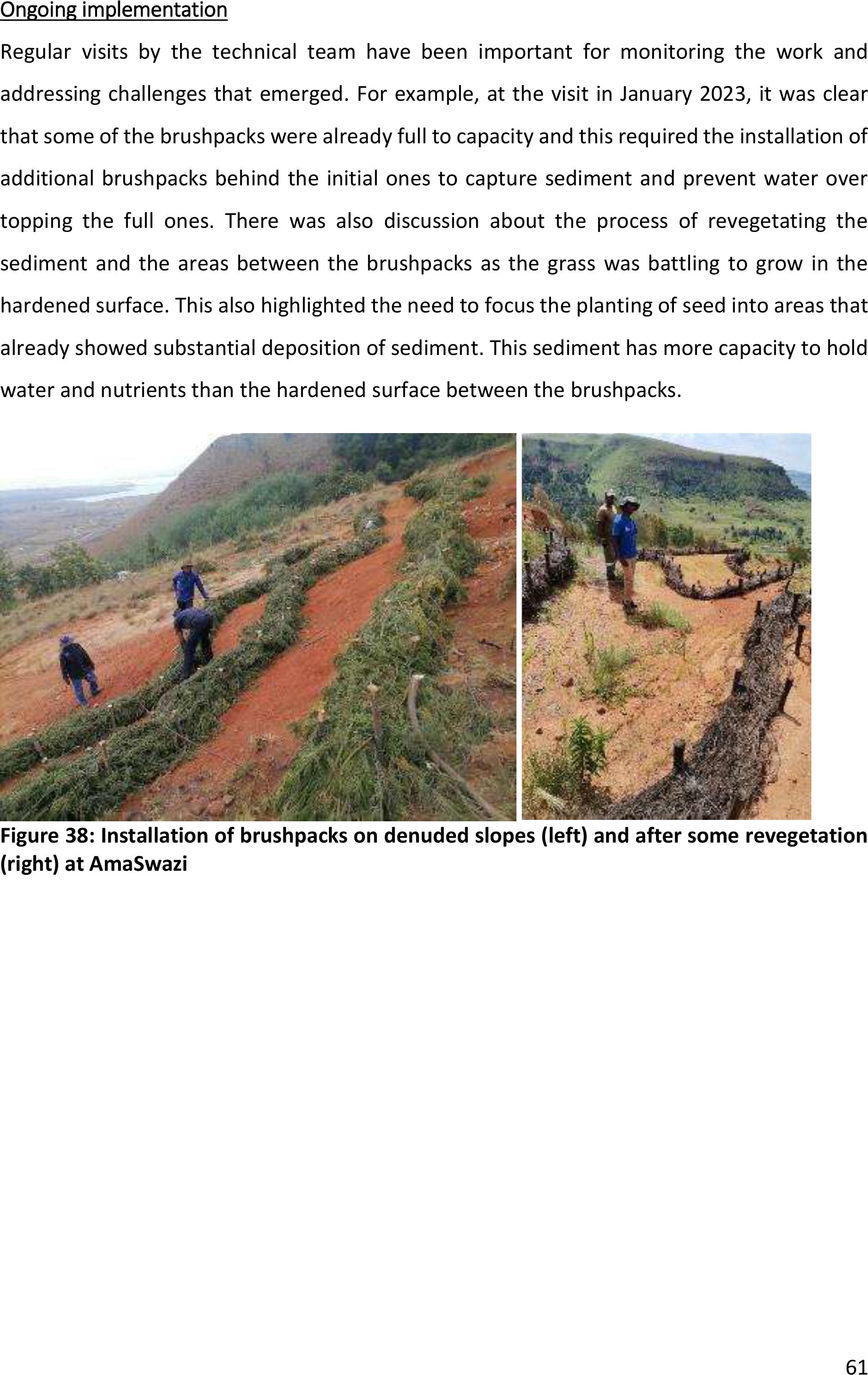
61
Ongoing implementation
Regular visits by the technical team have been important for monitoring the work and
addressing challengesthat emerged. For example, at the visit in January 2023, it was clear
that some of the brushpacks were already full to capacity and this required the installation of
additional brushpacks behind the initial ones to capture sediment and prevent water over
topping the full ones. There was also discussion about the process of revegetating the
sediment and the areas between the brushpacks as the grass was battling to grow in the
hardened surface. This also highlighted the need to focus the planting of seed into areas that
already showed substantial deposition of sediment. This sediment has more capacity to hold
water and nutrients than the hardened surface between the brushpacks.
Figure 38: Installation of brushpacks on denuded slopes (left) and after some revegetation
(right) at AmaSwazi
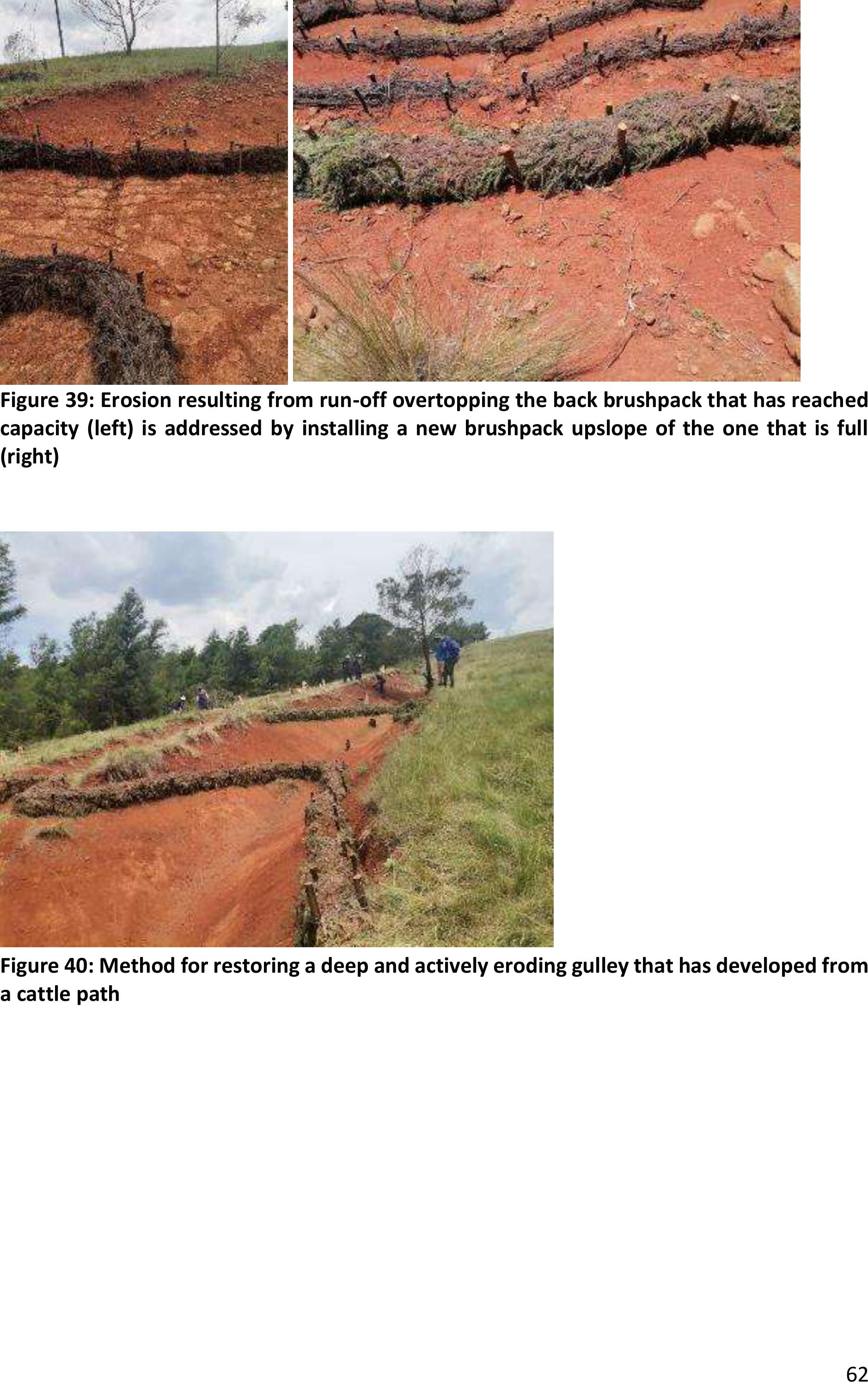
62
Figure 39: Erosion resulting from run-off overtopping the back brushpack that has reached
capacity (left) is addressed by installing a new brushpack upslope of the one that is full
(right)
Figure 40: Method for restoring a deep and actively eroding gulley that has developed from
a cattle path
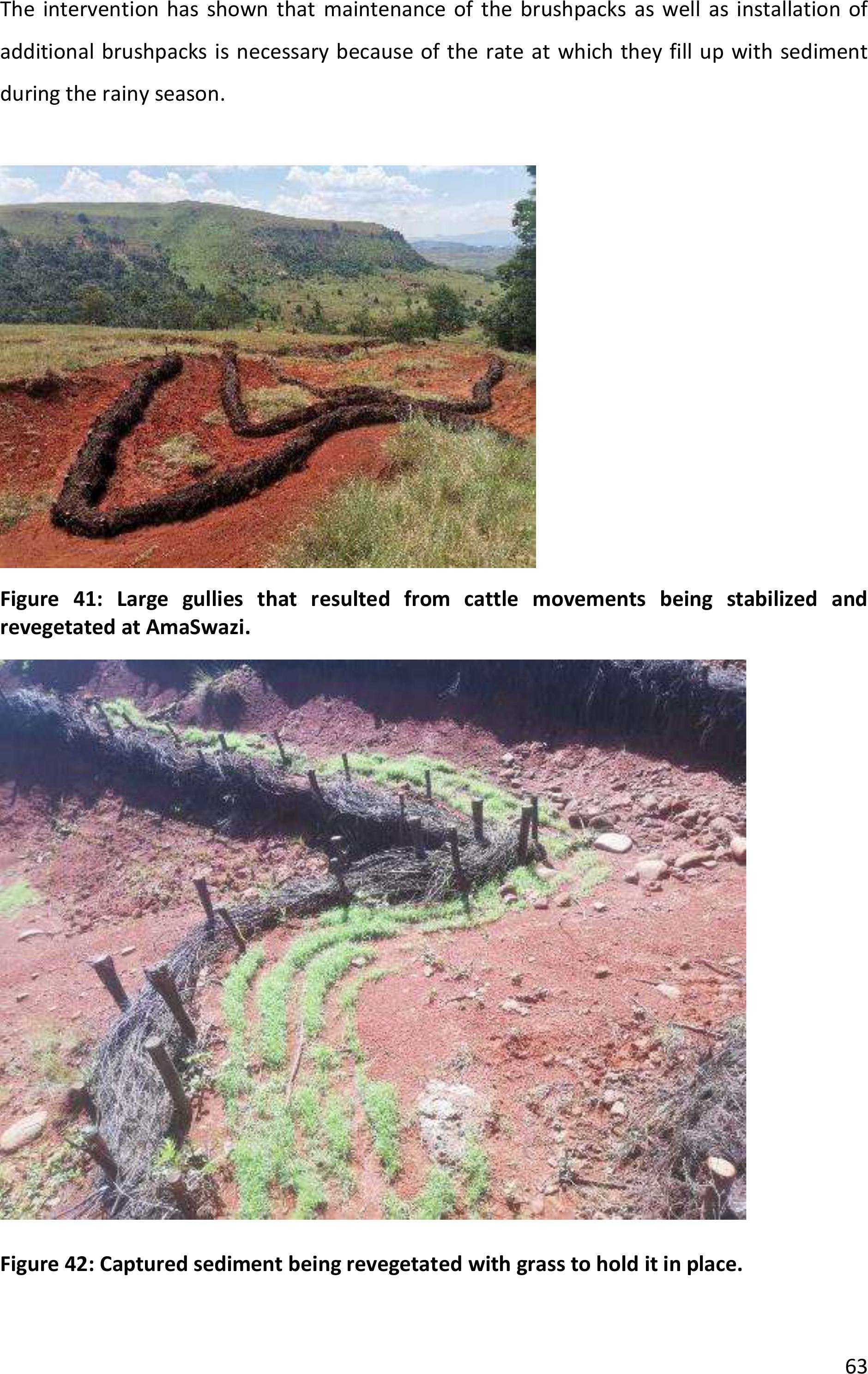
63
The intervention has shown thatmaintenance of the brushpacks as well as installation of
additional brushpacks is necessary because of the rate atwhich they fill up with sediment
during the rainy season.
Figure 41: Large gullies that resulted from cattle movements being stabilized and
revegetated at AmaSwazi.
Figure 42: Captured sediment being revegetated with grass to hold it in place.
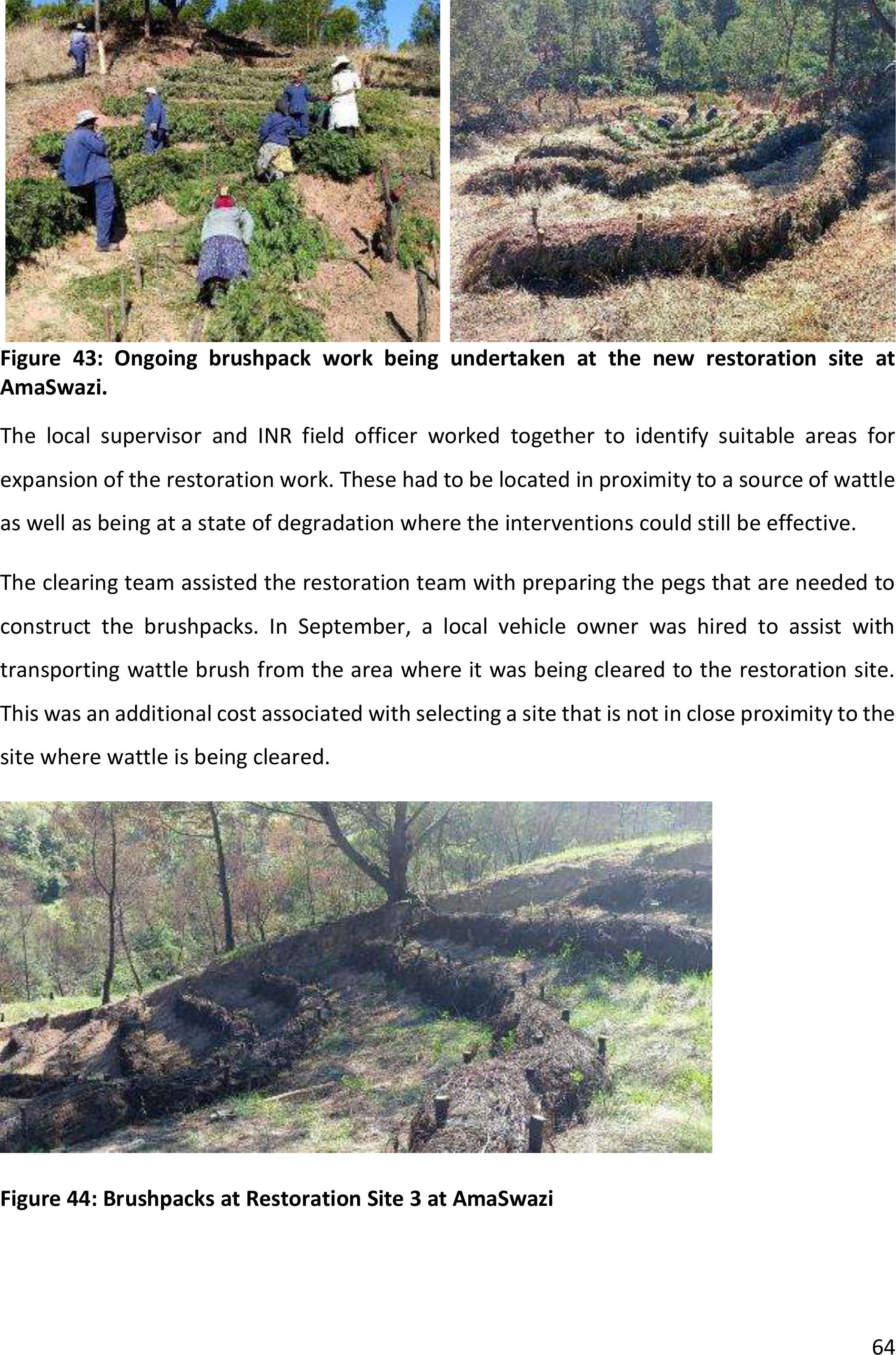
64
Figure 43: Ongoing brushpack work being undertaken at the new restoration site at
AmaSwazi.
The local supervisorand INR field officer workedtogether to identify suitable areas for
expansion of the restoration work. These had to be located in proximity to a source of wattle
as well as being at a state of degradation where the interventions could still be effective.
The clearing team assisted the restoration team withpreparing the pegs that are needed to
construct the brushpacks. In September, a local vehicle owner was hired to assist with
transporting wattle brush from the area where it was being cleared to the restoration site.
This was an additional cost associated with selecting a site that is not in close proximity to the
site where wattle is being cleared.
Figure 44: Brushpacks at Restoration Site 3 at AmaSwazi
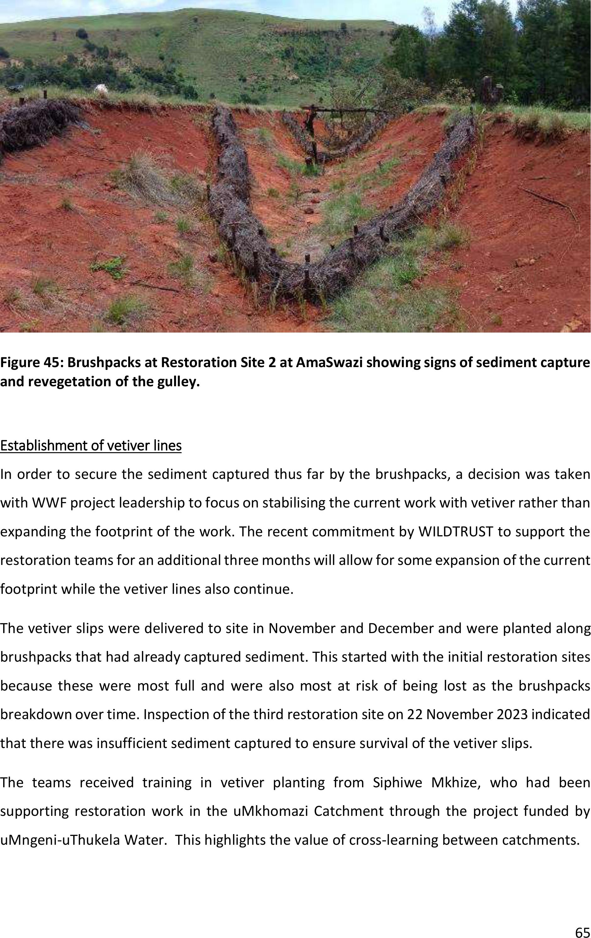
65
Figure 45: Brushpacks at Restoration Site 2 at AmaSwazi showing signs of sediment capture
and revegetation of the gulley.
Establishment of vetiver lines
In order to secure the sediment captured thus far by the brushpacks, a decision was taken
with WWF project leadership to focus on stabilising the current work with vetiver rather than
expanding the footprint of the work. The recent commitment by WILDTRUST to support the
restoration teams for anadditional three months will allow for some expansion of the current
footprint while the vetiver lines also continue.
The vetiver slips were delivered to site in November and December and were planted along
brushpacks that had already captured sediment. This started with the initial restoration sites
because these were most full and were also most at risk of being lost as the brushpacks
breakdown over time. Inspection of the third restoration site on 22 November 2023 indicated
that there was insufficient sediment captured to ensure survival of the vetiver slips.
The teams received training in vetiver planting from Siphiwe Mkhize, who hadbeen
supporting restoration work in the uMkhomazi Catchment through the project funded by
uMngeni-uThukela Water.This highlights the value of cross-learning between catchments.
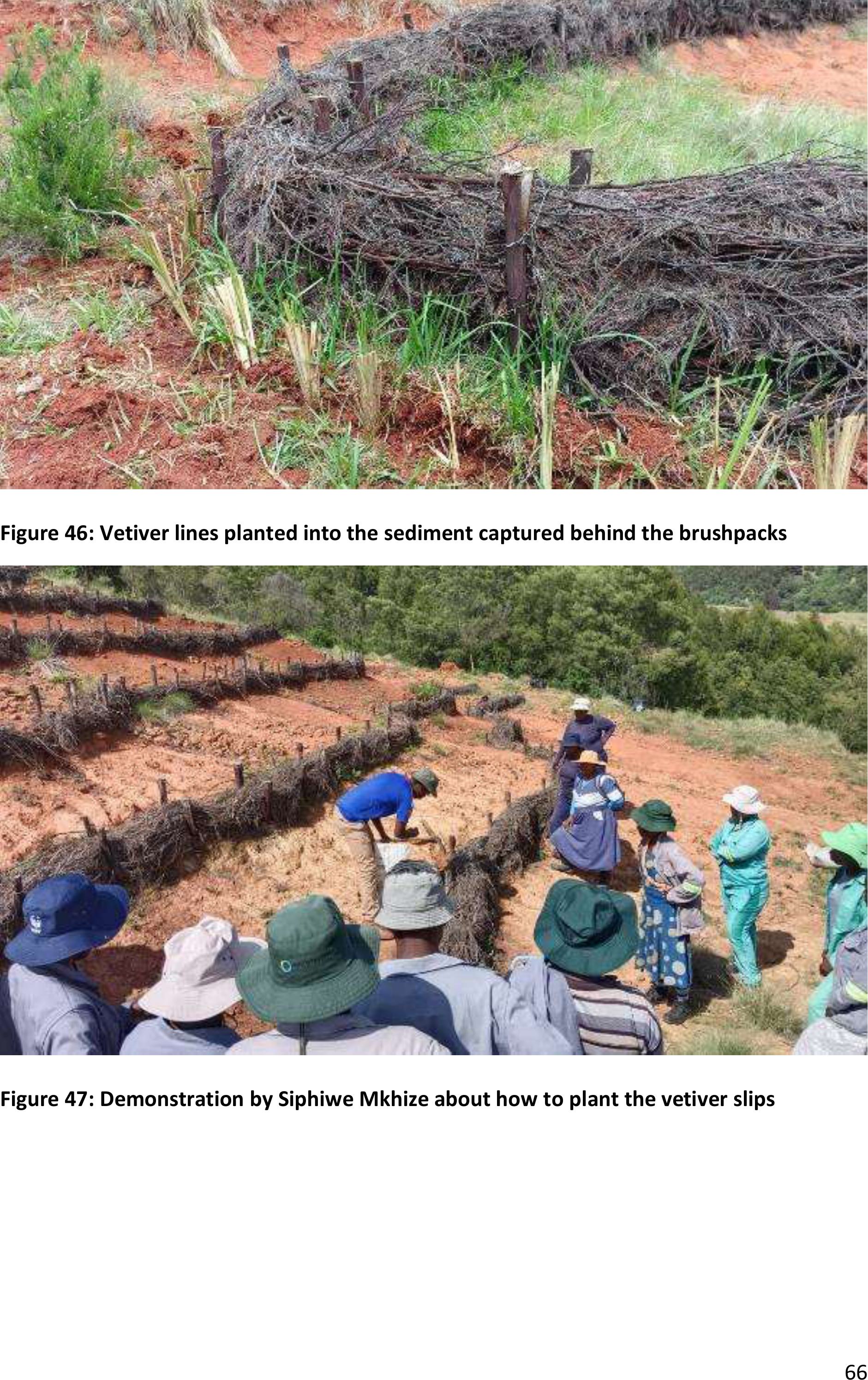
66
Figure 46: Vetiver lines planted into the sediment captured behind the brushpacks
Figure 47: Demonstration by Siphiwe Mkhize about how to plant the vetiver slips
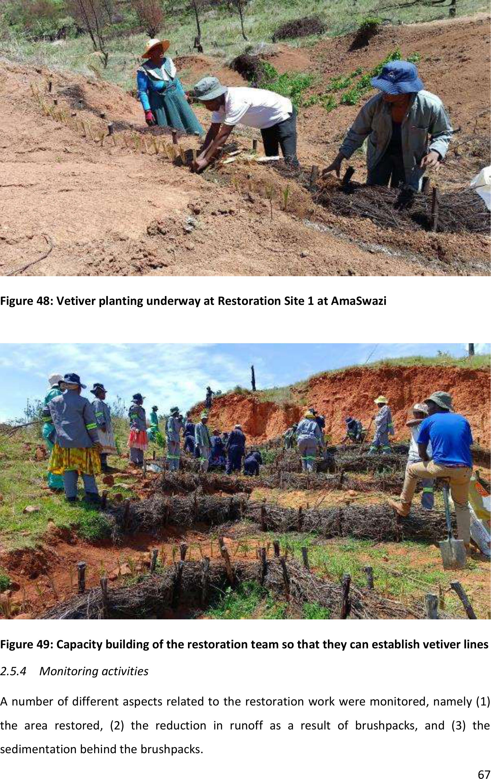
67
Figure 48: Vetiver planting underway at Restoration Site 1 at AmaSwazi
Figure 49: Capacity building of the restoration team so that they can establish vetiver lines
2.5.4Monitoring activities
A numberof different aspects related to the restoration work were monitored, namely (1)
the area restored, (2)the reduction in runoff asa result of brushpacks, and (3) the
sedimentation behind the brushpacks.
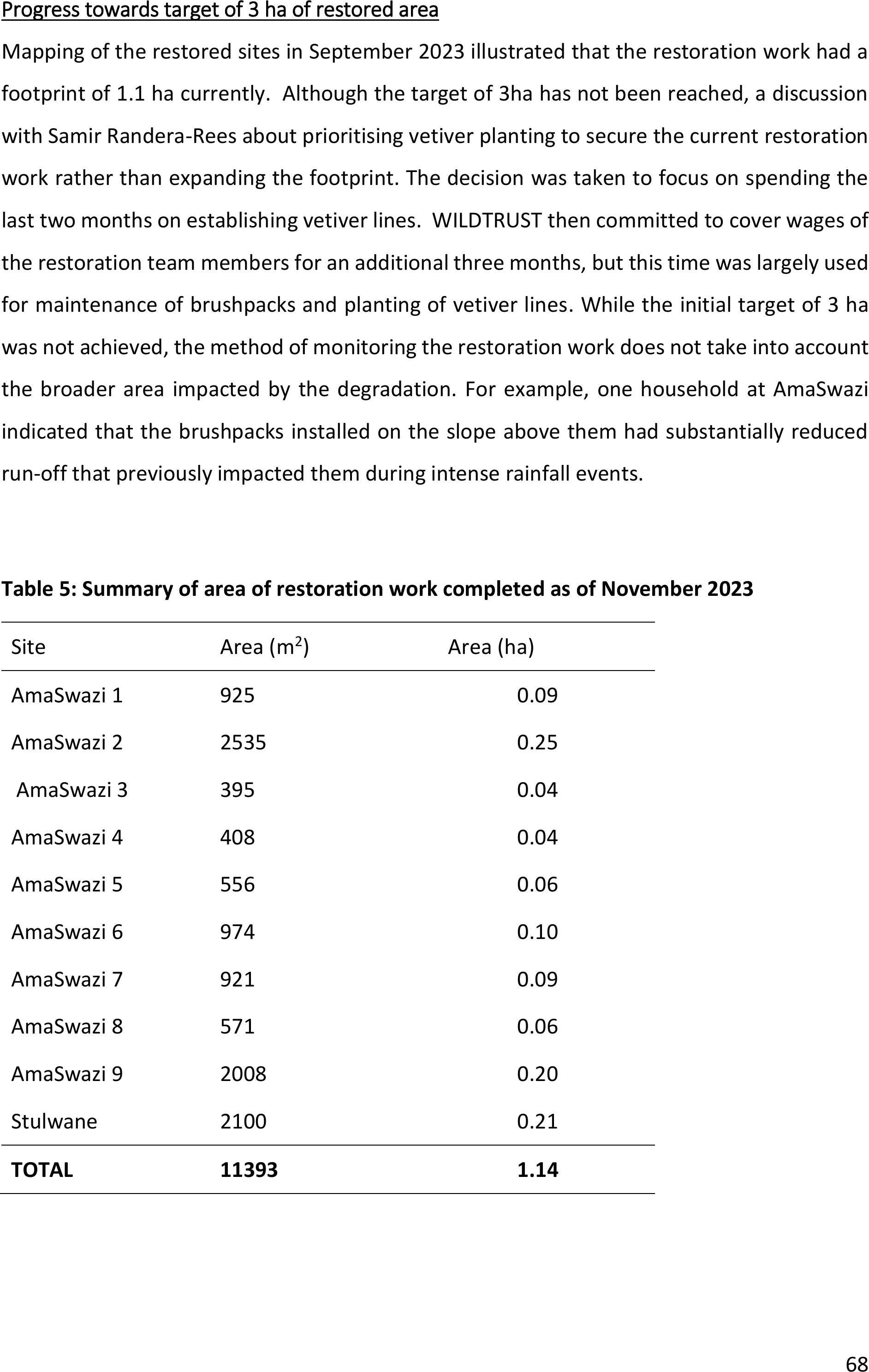
68
Progress towards target of 3 ha of restored area
Mapping of the restored sites in September 2023 illustrated that the restoration work had a
footprint of 1.1 ha currently. Although the target of 3ha has not been reached, a discussion
with Samir Randera-Rees about prioritising vetiver planting to secure the current restoration
work ratherthan expanding the footprint. The decision was taken to focus on spending the
last two months on establishing vetiver lines. WILDTRUST then committed to cover wages of
the restoration team members for an additional three months, but this time was largely used
for maintenance of brushpacks and planting of vetiver lines. While the initial target of 3 ha
was not achieved, the method of monitoring the restoration work does not take into account
the broader area impacted by the degradation. For example, one household at AmaSwazi
indicated that the brushpacks installed on the slope above them had substantially reduced
run-off that previously impacted them during intense rainfall events.
Table 5: Summary of area of restoration work completed as of November 2023
Site
Area (m2)
Area (ha)
AmaSwazi 1
925
0.09
AmaSwazi 2
2535
0.25
AmaSwazi 3
395
0.04
AmaSwazi 4
408
0.04
AmaSwazi 5
556
0.06
AmaSwazi 6
974
0.10
AmaSwazi 7
921
0.09
AmaSwazi 8
571
0.06
AmaSwazi 9
2008
0.20
Stulwane
2100
0.21
TOTAL
11393
1.14
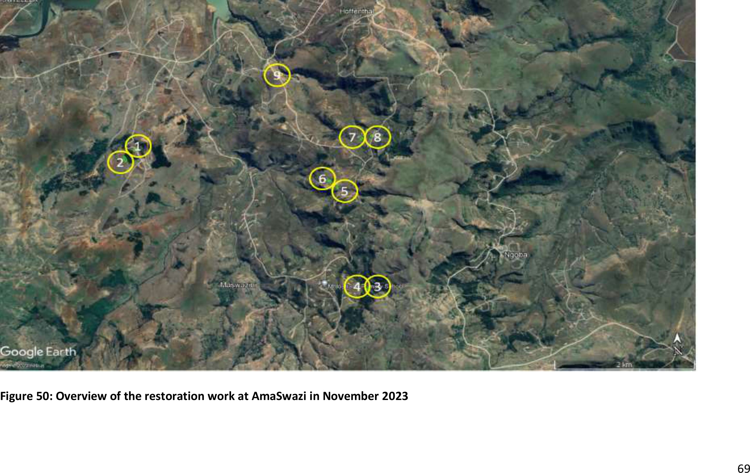
69
Figure 50: Overview of the restoration work at AmaSwazi in November 2023
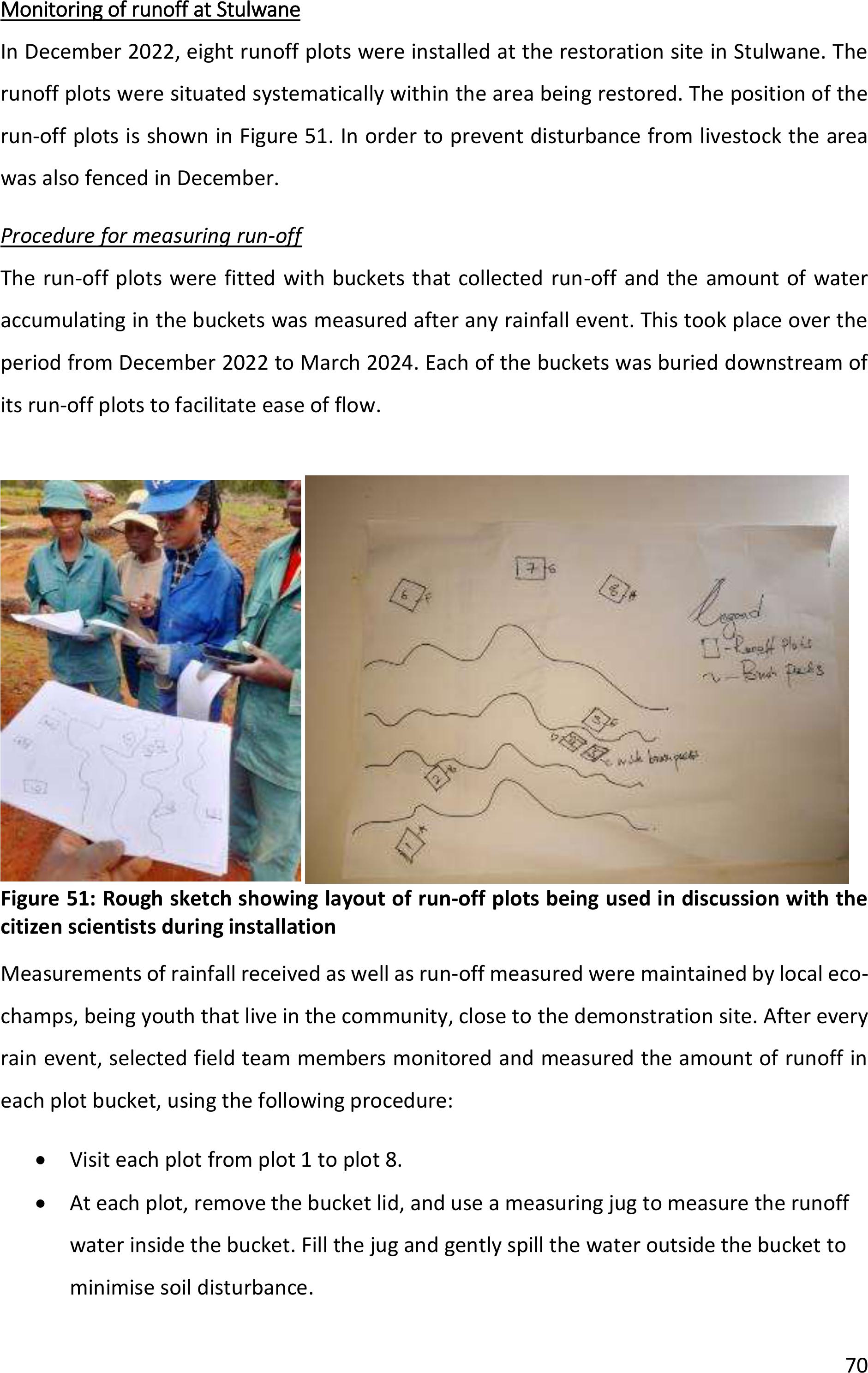
70
Monitoring of runoff at Stulwane
In December 2022, eight runoff plots were installed at the restoration site in Stulwane. The
runoff plots were situated systematically withinthe area being restored. The position of the
run-off plots is shown in Figure 51. In order to prevent disturbance from livestock the area
was also fenced in December.
Procedure for measuring run-off
The run-off plots were fitted with buckets that collected run-off and the amount of water
accumulating in the buckets was measured after any rainfall event. This took place over the
period from December 2022 to March 2024. Each of the buckets was buried downstream of
its run-off plots to facilitate ease of flow.
Figure 51: Rough sketch showing layout of run-off plots being used in discussion with the
citizen scientists during installation
Measurements of rainfall received as well as run-off measured were maintained by local eco-
champs, being youth that live in the community, close to the demonstration site. After every
rain event, selected field team members monitored and measured the amount of runoff in
each plot bucket, using the following procedure:
•Visit each plot from plot 1 to plot 8.
•At each plot, remove the bucket lid, and use a measuring jug to measure the runoff
water inside the bucket. Fill the jug and gently spill the water outside the bucket to
minimise soil disturbance.
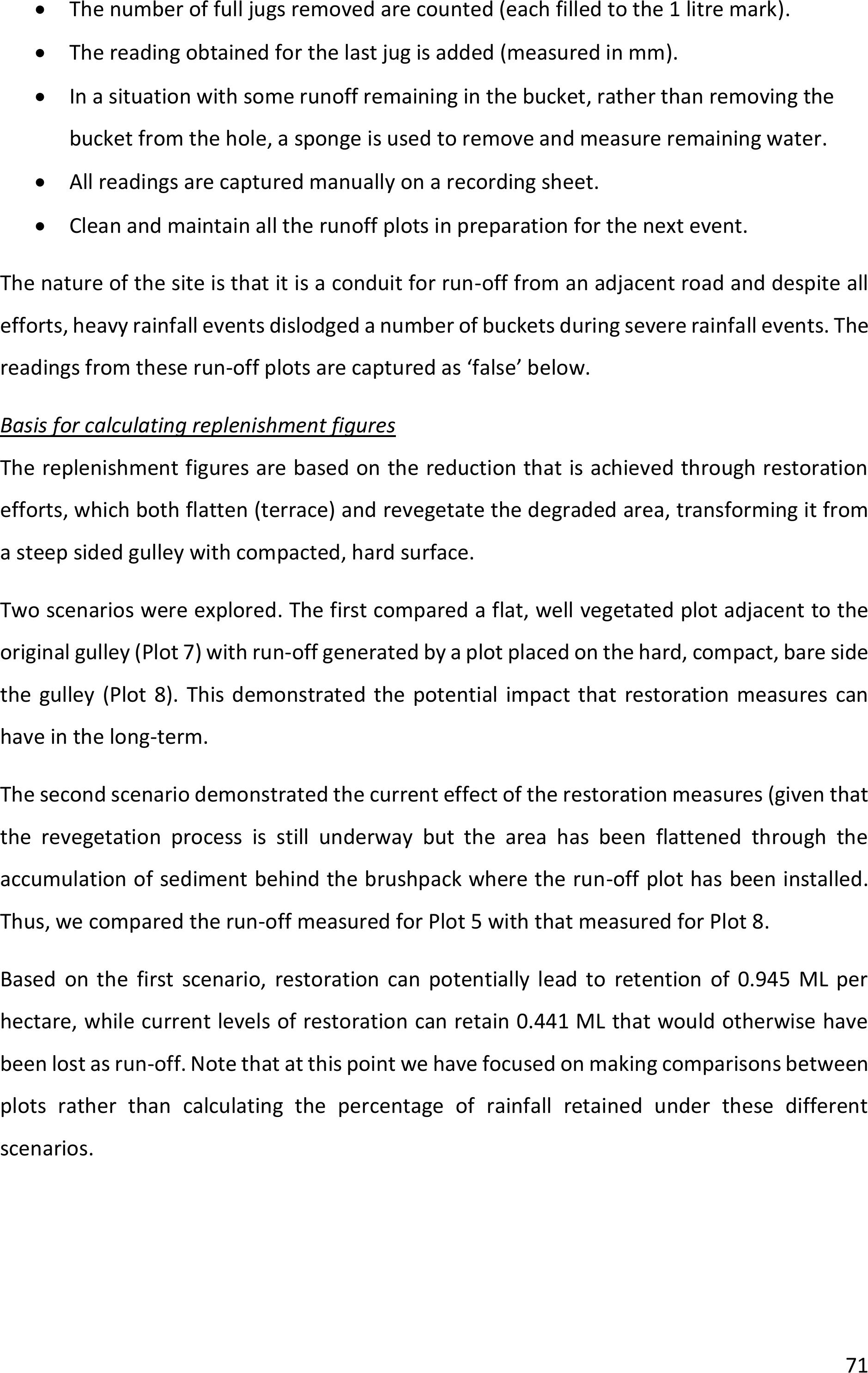
71
•The number of full jugs removed are counted (each filled to the 1 litre mark).
•The reading obtained for the last jug is added (measured in mm).
•In a situation with some runoff remaining in the bucket, rather than removing the
bucket from the hole, a sponge is used to remove and measure remaining water.
•All readings are captured manually on a recording sheet.
•Clean and maintain all the runoff plots in preparation for the next event.
The nature of the site is that it is a conduitfor run-off from an adjacent road and despite all
efforts, heavy rainfall events dislodged a number of buckets during severe rainfall events. The
readings from these run-off plots are captured as ‘false’ below.
Basis for calculating replenishment figures
The replenishment figures are based on the reduction that is achieved through restoration
efforts, which both flatten (terrace) andrevegetate the degraded area, transforming it from
a steep sided gulley with compacted, hard surface.
Two scenarios were explored. The first compared a flat, well vegetated plot adjacent to the
original gulley (Plot 7) with run-off generated by a plot placed on the hard, compact, bare side
the gulley (Plot 8). This demonstrated the potential impact that restoration measures can
have in the long-term.
The second scenario demonstrated the current effect of the restoration measures (given that
the revegetation process is still underway but the area has been flattened through the
accumulation of sediment behind the brushpack where the run-off plot has been installed.
Thus, we compared the run-off measured for Plot 5 with that measured for Plot 8.
Based on the first scenario, restoration can potentially lead to retention of 0.945 ML per
hectare, while current levels of restoration can retain 0.441 ML that would otherwise have
been lost as run-off. Note that at this point we have focused on making comparisons between
plots rather than calculating the percentage of rainfall retained under these different
scenarios.
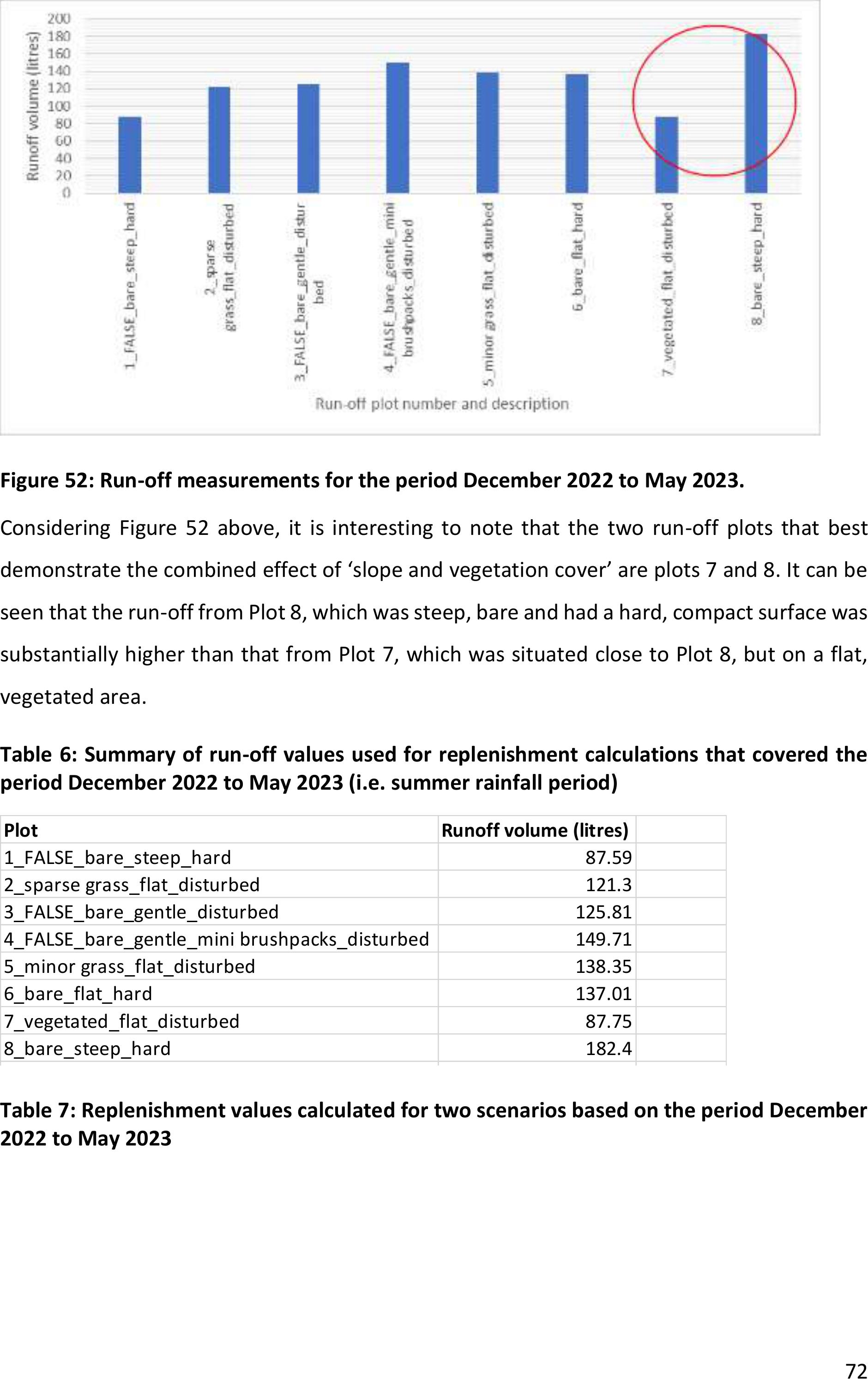
72
Figure 52: Run-off measurements for the period December 2022 to May 2023.
Considering Figure 52above, it is interesting to note that the two run-off plots that best
demonstrate the combined effect of ‘slope and vegetation cover’ are plots 7 and 8. It can be
seen that the run-off from Plot 8, which was steep, bare and had a hard, compact surface was
substantially higher than that from Plot 7, which was situated close to Plot 8, but on a flat,
vegetated area.
Table 6: Summary of run-off values used for replenishment calculations that covered the
period December 2022 to May 2023 (i.e. summer rainfall period)
Table 7: Replenishment values calculated for two scenarios based on the period December
2022 to May 2023
PlotRunoff volume (litres)
1_FALSE_bare_steep_hard 87.59
2_sparse grass_flat_disturbed121.3
3_FALSE_bare_gentle_disturbed 125.81
4_FALSE_bare_gentle_mini brushpacks_disturbed149.71
5_minor grass_flat_disturbed138.35
6_bare_flat_hard 137.01
7_vegetated_flat_disturbed 87.75
8_bare_steep_hard 182.4
Replenishishment calculation
Compare plots 7 (vegetated and flat pre-restoration) and 8 (steep, bare & hard):
Amount of water retained in plot 7 is difference94.65litres
So on 1 m2 we hold94.65litres
Thus on 1 ha (10000 m2)946500 litres
There are 1,000,000 litres in a megalitre
Thus, per hectare restored this holds0.9465ML
Thus, on 3 hectares, this holds2.8395ML
THIS DEMONSTRATES POTENTIAL
Replenishishment calculation
Compare plots 5 (partial restoration) and 8 (steep, bare & hard):
Amount of water retained in plot 7 is difference44.05litres
So on 1 m2 we hold44.05litres
Thus on 1 ha (10000 m2)440500 litres
There are 1,000,000 litres in a megalitre
Thus, per hectare restored this holds0.4405ML
Thus, on 3 hectares, this holds1.3215ML
THIS SHOWS CURRENT SITUATION

73
Some challenges were experienced with the measuring runoff, which include:
•The ecochamps have had to learn how to record the run-off and have adapted their
method since they found that constant removal of the buckets from the holes led to
the edges crumbling and soil accumulating at the base of the holes, which lifted the
buckets and prevented the free flow of water into the buckets.
•Events with strong rainstorms in early February 2023 washed the buckets out of the
holes on some runoff plots so the team secured them with wire and stakes to
prevent it happening in future.
•Community members that walked past during the construction of the fence on site
kept asking questions about the fence's safety and there are concerns that it may be
stolen.
Ongoing maintenance of the run-off plots
Prior to the field trip to Stulwane in late September 2023, maintenance was done on the run-
off plots at Stulwane because there had been some deterioration in the equipment. One of
PlotRunoff volume (litres)
1_FALSE_bare_steep_hard 87.59
2_sparse grass_flat_disturbed121.3
3_FALSE_bare_gentle_disturbed 125.81
4_FALSE_bare_gentle_mini brushpacks_disturbed149.71
5_minor grass_flat_disturbed138.35
6_bare_flat_hard 137.01
7_vegetated_flat_disturbed 87.75
8_bare_steep_hard 182.4
Replenishishment calculation
Compare plots 7 (vegetated and flat pre-restoration) and 8 (steep, bare & hard):
Amount of water retained in plot 7 is difference94.65litres
So on 1 m2 we hold94.65litres
Thus on 1 ha (10000 m2)946500 litres
There are 1,000,000 litres in a megalitre
Thus, per hectare restored this holds0.9465ML
Thus, on 3 hectares, this holds2.8395ML
THIS DEMONSTRATES POTENTIAL
Replenishishment calculation
Compare plots 5 (partial restoration) and 8 (steep, bare & hard):
Amount of water retained in plot 7 is difference44.05litres
So on 1 m2 we hold44.05litres
Thus on 1 ha (10000 m2)440500 litres
There are 1,000,000 litres in a megalitre
Thus, per hectare restored this holds0.4405ML
Thus, on 3 hectares, this holds1.3215ML
THIS SHOWS CURRENT SITUATION
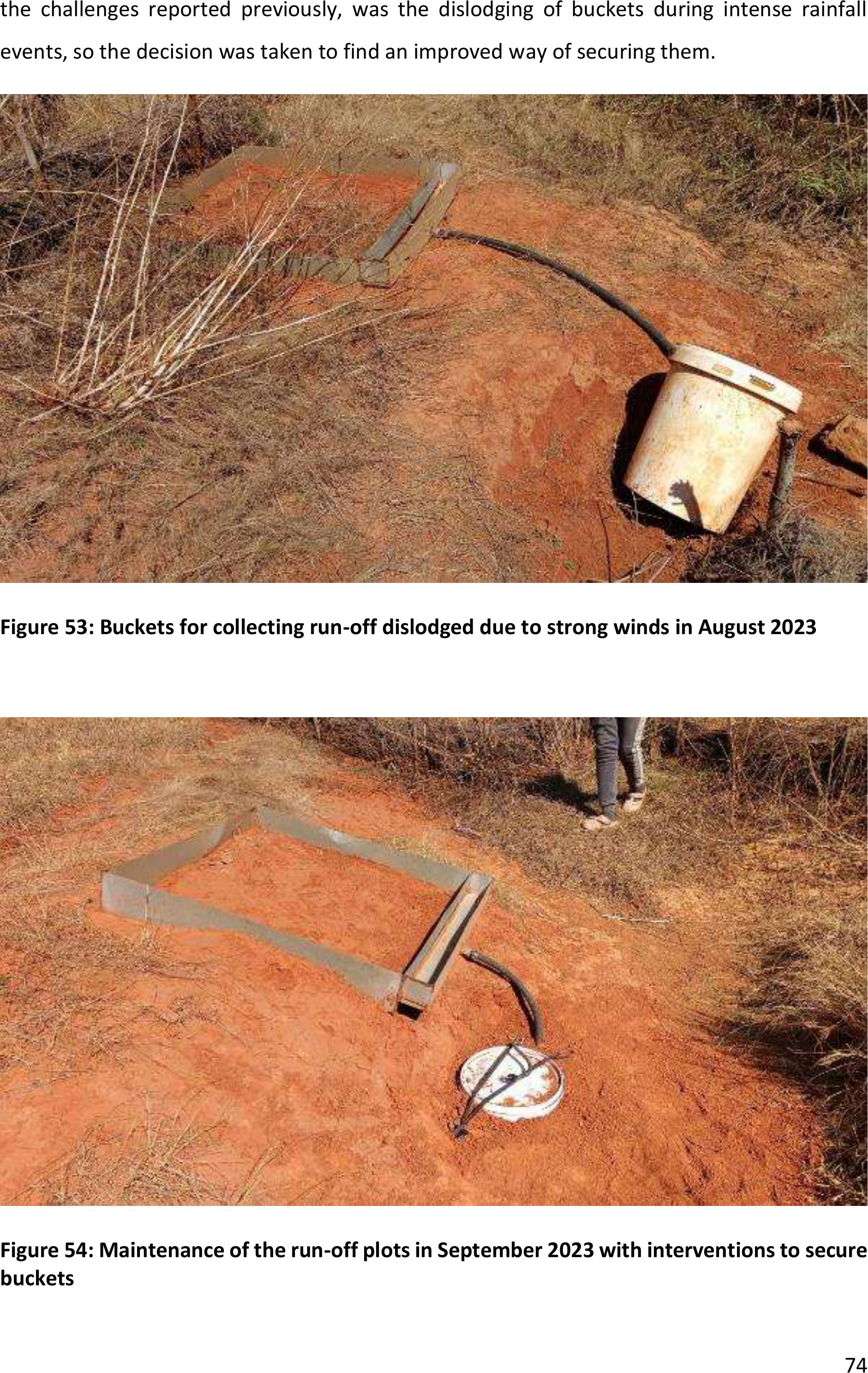
74
the challenges reported previously, was the dislodging of buckets during intense rainfall
events, so the decision was taken to find an improved way of securing them.
Figure 53: Buckets for collecting run-off dislodged due to strong winds in August 2023
Figure 54: Maintenance of the run-off plots in September 2023 with interventions to secure
buckets
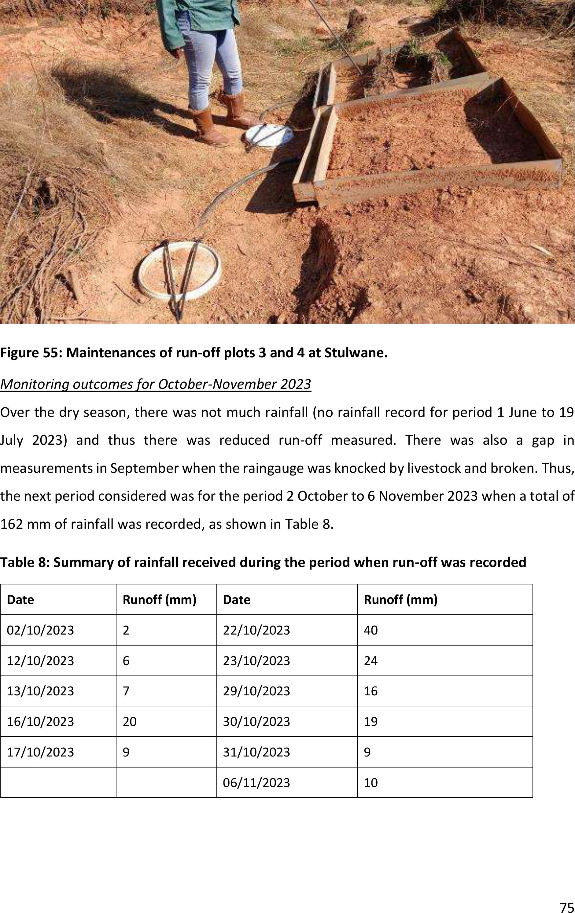
75
Figure 55: Maintenances of run-off plots 3 and 4 at Stulwane.
Monitoring outcomes for October-November 2023
Over the dry season, there was not much rainfall (no rainfall record for period 1 June to 19
July 2023) and thusthere was reduced run-off measured. There was also a gap in
measurements in September when the raingauge was knocked by livestock and broken.Thus,
the next period considered was for the period 2 October to 6 November 2023 when a total of
162 mm of rainfall was recorded, as shown in Table 8.
Table 8: Summary of rainfall received during the period when run-off was recorded
Date
Runoff (mm)
Date
Runoff (mm)
02/10/2023
2
22/10/2023
40
12/10/2023
6
23/10/2023
24
13/10/2023
7
29/10/2023
16
16/10/2023
20
30/10/2023
19
17/10/2023
9
31/10/2023
9
06/11/2023
10
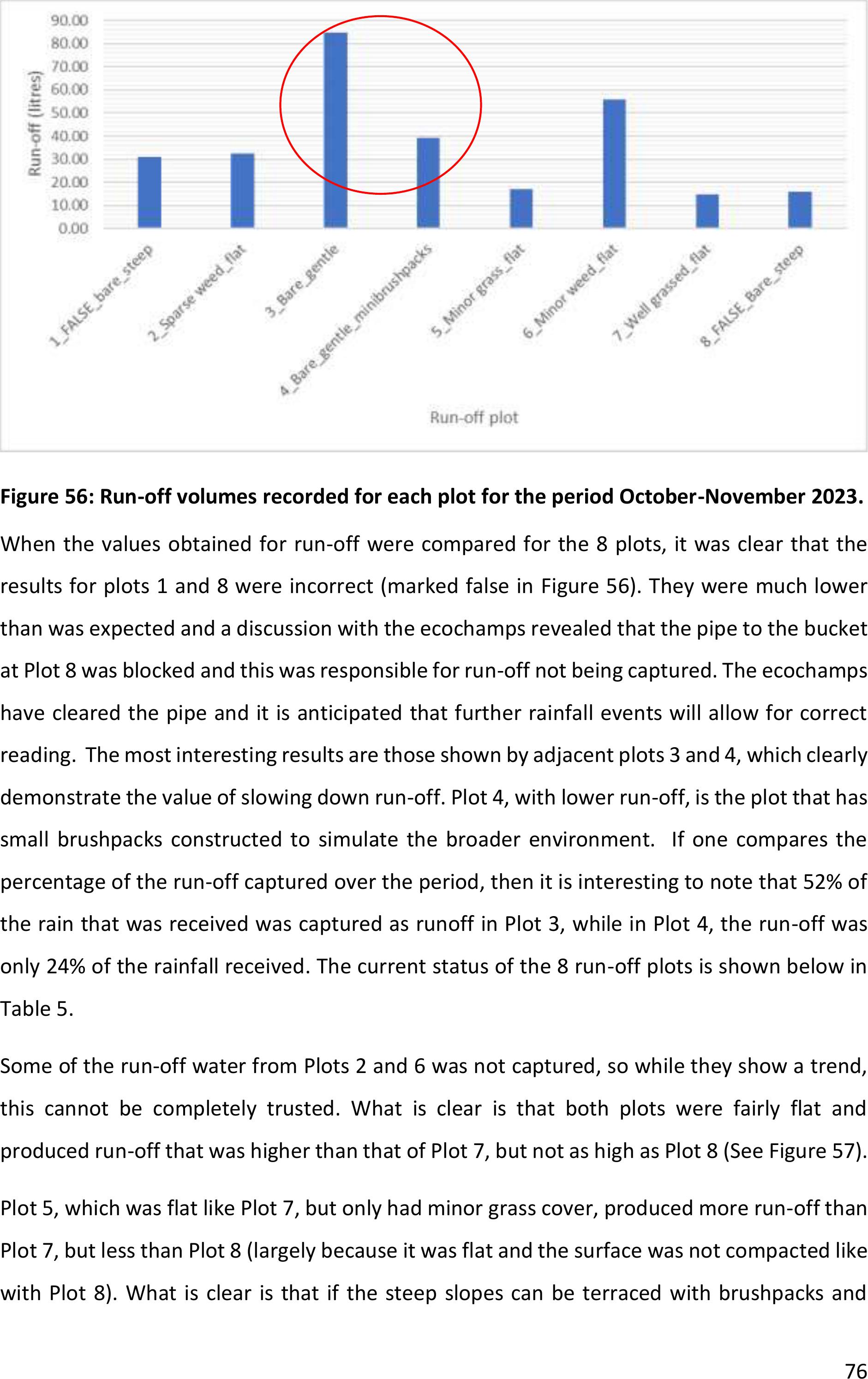
76
Figure 56: Run-off volumes recorded for each plot for the period October-November 2023.
When the values obtained for run-off were compared for the 8 plots, it was clear that the
results for plots 1 and 8 were incorrect (marked false in Figure 56).They were muchlower
than was expected and a discussion with the ecochamps revealed that the pipe to the bucket
at Plot 8 was blocked and this was responsible for run-off not being captured. The ecochamps
have cleared the pipe and it is anticipated that further rainfall events will allow for correct
reading. The most interesting results are those shown by adjacent plots 3 and 4, which clearly
demonstrate the value of slowing down run-off. Plot 4, with lower run-off, is the plot that has
small brushpacks constructed to simulate the broader environment. If one compares the
percentage of the run-off captured over the period, then it is interesting to note that 52% of
the rain that was received was captured asrunoff in Plot 3, while in Plot 4, the run-off was
only 24% of therainfall received. The current status of the 8 run-off plots is shown below in
Table 5.
Some of the run-off water from Plots 2 and 6 was not captured, so while they show a trend,
this cannot be completely trusted. What is clear is that both plots were fairly flat and
produced run-off that was higher than that of Plot 7, but not as high as Plot 8 (See Figure 57).
Plot 5, which was flat like Plot 7, but only had minor grass cover, produced more run-off than
Plot 7, butless than Plot 8 (largely because it was flat and the surface was not compacted like
with Plot 8). What is clear is that if the steep slopes can be terraced with brushpacks and
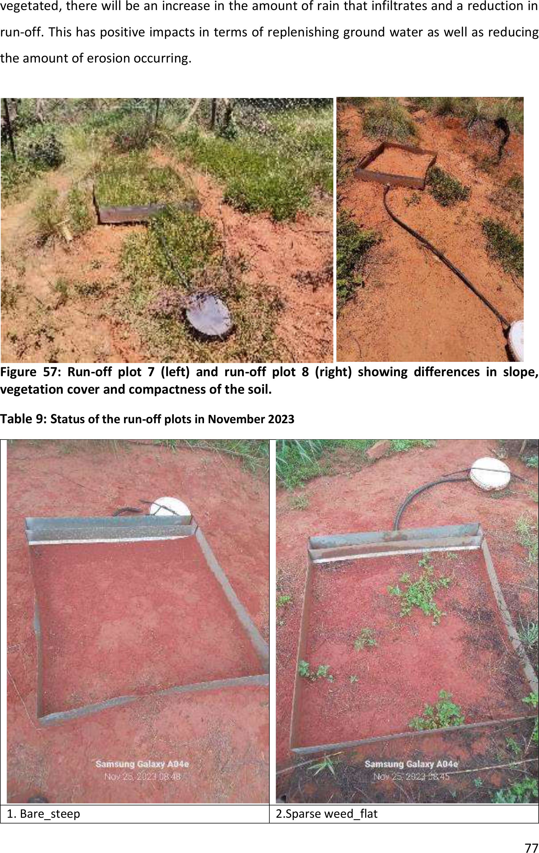
77
vegetated, there will be an increase in the amount of rain that infiltrates anda reduction in
run-off. This has positive impacts in terms of replenishing ground water as well as reducing
the amount of erosion occurring.
Figure 57: Run-off plot 7 (left) and run-off plot 8(right) showing differences in slope,
vegetation cover and compactness of the soil.
Table 9: Status of the run-off plots in November 2023
1. Bare_steep
2.Sparse weed_flat
78
3. Bare_gentle
4. Bare_gentle_mini brushpacks
5. minor grass_flat
6. Minor weed_flat
79
7. Well grassed_flat
8. Bare_steep
Monitoring impacts of restoration: Sediment deposition
The sediment monitoring requires ongoing measurements of the amount of sediment that is
held by each brushpack. The INR has developed a system for measuring the depth and width
of the sediment along each brushpack, which is then converted to a volume.
Sediment measurement at Stulwane
Monitoring of sediment accumulation at Stulwane has clearly demonstrated the value of
brushpacks in retaining sediment within the system rather than allowing it to be removed.
The first brushpacks at the demonstration site have a total length of 88 m and had captured
a total of 4.89 cubic metres of sediment by end January 2023 (See Appendix 2 for more detail).
80
Figure 58: Photographs depicting themeasurements used to calculate the volume of
sediment collected
Sediment measurements at AmaSwazi
Based on measurements taken at 10 sites across a total of 68 brushpacks with atotal length
of 1289 m, and an average accumulation of sediment of 0.045 m3/m, the total amount of
sediment retained by the restoration was 58 m3, as shown in Table 10.
Table 10: Summary of sediment-related values
Total distance of brushpacks
1 289
m
Average sediment accumulated
0,045
m3/m
Total amount of sediment
58
m3
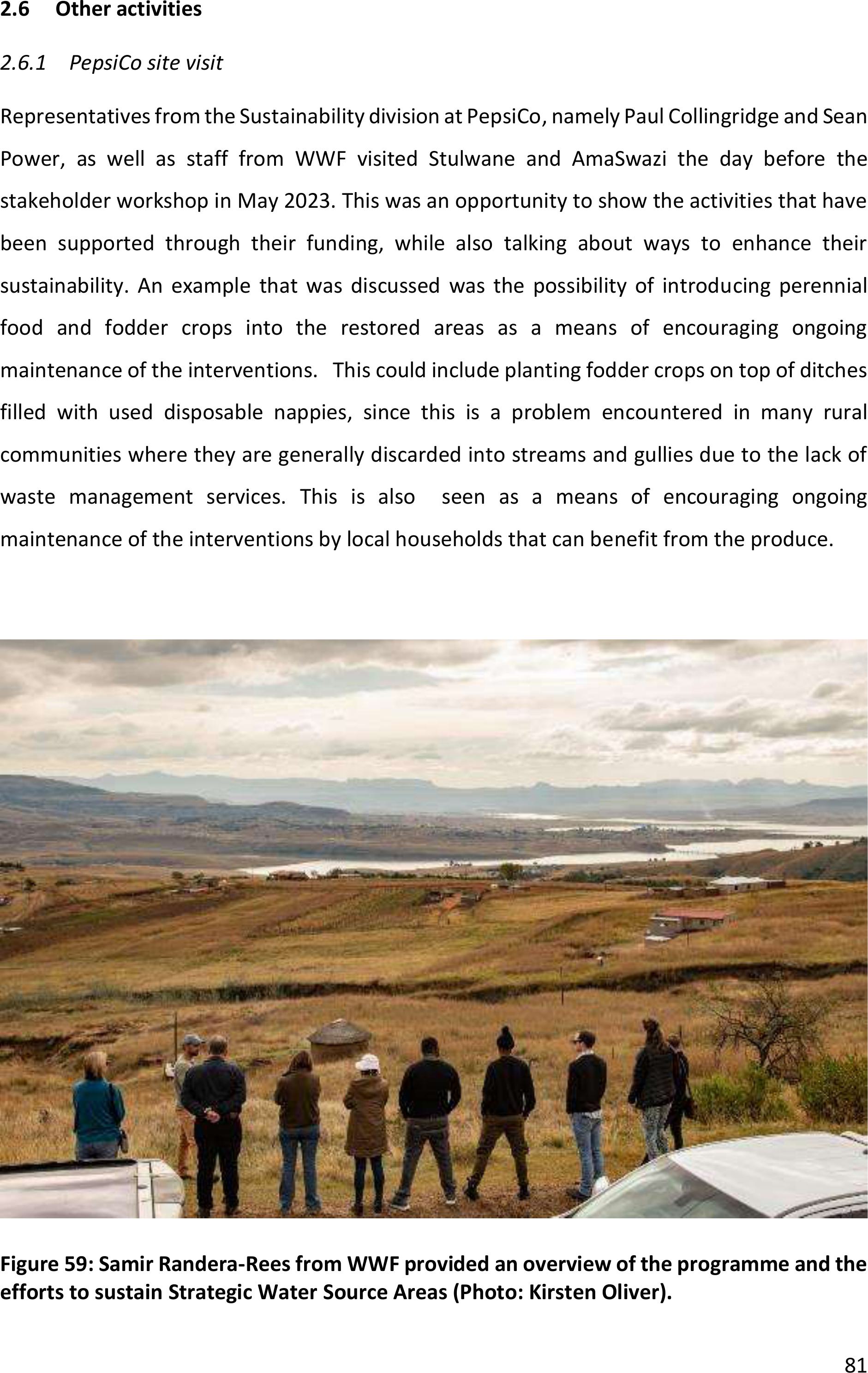
81
2.6Other activities
2.6.1PepsiCo site visit
Representatives from the Sustainability division atPepsiCo, namely Paul Collingridge and Sean
Power, as well as staff from WWF visited Stulwane and AmaSwazi the day before the
stakeholder workshop in May 2023. This was an opportunity to show the activities that have
been supported through their funding, while also talking about ways to enhance their
sustainability. An example that was discussed was the possibility of introducing perennial
food and fodder crops into the restored areas as a means of encouraging ongoing
maintenance of the interventions. This could include planting fodder crops on top of ditches
filled with used disposable nappies, since this is a problem encountered in many rural
communities where they are generally discarded into streams and gullies due to the lack of
waste management services. This is also seen as a means of encouraging ongoing
maintenance of the interventions by local households that can benefit from the produce.
Figure 59: Samir Randera-Rees from WWF provided an overview of the programme and the
efforts to sustain Strategic Water Source Areas (Photo: Kirsten Oliver).
82
3LESSONS LEARNT AND RECOMMENDATIONS
Some of the challenges that have been encountered during this reporting period are
summarised here:
•Threat of fire that could destroy the restoration interventions has emerged and the
teams at both sites took steps to burn fire breaks that will reduce the risk. Burning of
fire breaks is itself a risk, which is why a suitably trained and equipped team was
brought in to burn the breaks at AmaSwazi before the close of the fire season.
•There were some problems with livestock damaging brushpacks and grazing
revegetation. At Stulwane, the demonstration site was fenced to protect the
investment in the restoration interventions as well as the run-off plots. At AmaSwazi,
this was not possible and the best option will be for brushwood to be scattered over
the revegetated areas to discourage livestock.
•It is not always easy to identify sites for restoration work as many of the sites identified
on Google Earth, or identified by community members are too degraded for the brush
packs to be an effective intervention.
•Sometimes the sites that are identified as suitable arenot located in close proximity
to where there is wattle that the teamshave permission to clear and this requires that
the cut brush be transported to the restoration site, which has an associated cost.
•The very steep areas being restored require a lot of brushpacks as they need to be
placed at fairly vertical height intervals.
•From a livelihood perspective, the team members would have preferred to be
appointed for the full month rather than for 10 days per month however the budget
did not allow for this and the decision was taken to stretch it over a longer period
rather than halving the contract period.
•The process of identifying areas for clearing and then being able to select areas for
restoration required that the team supervisor engaged effectively with both the
Traditional Authority as well as members of the community.
•It is interesting to note that there were multiple cases where community members
approached the team supervisor with suggestions of degradedareas requiring
intervention. This demonstrated awareness of the effectiveness of the interventions
as well as concern about how existing gullies are expanding and deepening. However,
83
some of the areas identified were just to badly eroded to allow for the restoration
teams to get involved.
•The team has combined old and new knowledge about controlling erosion and in some
areas where the ground was too hard to install brushpacks they combined them with
stonelines.
4 CONCLUSION
This project, which focused onestablishing a multi-stakeholder partnership inthe Northern
Drakensberg SWSA,with a focus on the upper uThukela Catchment, led to the formation of
the Northern Drakensberg Collaborative. While the partnership is still being formalized, the
participation of range ofstakeholders in the most recent event in Bergville inMarch 2024
clearly demonstrates that they see value in participating. Furthermore, the number of
stakeholders that requested to be included in the agenda to share information shows that the
NDC is a useful platform for sharing and learning.
In terms of the restoration work, many practical lessons were learntfor the project team as
well as the NDC members. They have demonstrated that brushpacks both reduce run-off and
allow for the accumulation of sediment that would otherwise be transported from the
environment and deposited in rivers.
The partners have undertaken to work towards holding a face-to-face event in June 2024,
which is beyond the timeframe of the project. A number of organisations including WWF have
committed to resource the event, which shows commitment and buy-in.
Acknowledgement
The INR acknowledges WWF-SA and PepsiCo for supporting the establishment of the
Northern Drakensberg Collaborative and for associated activities.