
Two-day workshop: Sokhulu –Restoration on the
oodplains. 21-21 August 2024
1.1INTRODUCTION
This workshop falls within the following activity sets within the overall programme:
➢Activity 3.2.2 b and c: workshop 1- identication of farmers farming along oodplains
(Wildtrust restoration team) and
➢Activity 5.4.1 b: CCA workshop and identication of challenges and potential adaptive
strategies (Mahlathini Development Foundation- MDF)
This activity links with restoration as it is part of riparian zone restoration through the climate
adaptation work focused on the estuarine functional zones. The intention is to support alien
species plant and solid waste removal and replanting of indigenous natural riparian and littoral
vegetation, thus dampening the eects of oods and erosion, improving water quantity and
quality for people who rely on this water for drinking, cleaning, and watering crops.
An initial process of identication of farmers in Sokhulu active on the ood plains and the
relationship of these activities to homestead based activities as well as wetland and riparian
functioning is required to plan the interventions both for restoration and for climate resilient
agriculture.
To date, MDF has undertaken a number of site visits and has collaborated with UKZN to
undertake the baseline interviews for the Sokhulu community (eight villages). The latter is not
yet nalised.
1.2PURPOSE OF THE WORKSHOP
The purpose of the workshop is multi-pronged and contained the following aspects:
The purpose of the workshop is to:
➢Ascertain information on current land-use and farming practices engaged in by
Sokhulu subsistence farmers.
➢To discuss climate change and how it has aected subsistencefarmers in South
Africa and Sokhulu, specically.
➢Discuss sustainable and unsustainable farming and land-use practices- linking to
the negative environmental impacts of cropping along the oodplain.
➢Find out where locals are cropping which will assist in identifying some of the
farmers that will participate in the tree-growers activity.
➢Find out which indigenous trees are found in the community and what the
community members use them for.
To this end, the YES youth volunteers and hub sta invited community members from all eight
villages involved in the oodplains to attend the workshop – working through the traditional
council and also doing door to door canvassing.
This was followed in the afternoon of day one and morning of day 2 with visits to the dierent
sections of the oodplain. For each of the seven villages, generational access to elds in the
oodplain have been provided. The area is extensive (roughly 400 hectares) and in principle

each household from these villages has access to land on the oodplain. Fields/plots are
roughly 1500m2 each, allowing for 2 600 plots on the plain. A number of these plots have been
consolidated for a selection of farmers to areas between 1-8ha. It is estimated that between
100-250 farmers are active in these elds.
1.3WORKSHOP OUTLINE
Item
Description
Material required
Time
Purpose of the
day
Introduction of the team and outlining intention of
restoration activities and farming support
Vusi -Wildtrust
Introductions
Attendees to state their name, village and activities in
the oodplain incl crops grown
Mazwi-MDF
Attendance register
30
minutes
Discussion
Who is involved in the oodplains? Participants would
be asked to sit in their village groups mapping out
where activities are in the oodplains and marking
those out.
Maps, kokis,
markers
15-20
minutes
Plenary
Discussion of climate change impacts: Have farmers
noticed changed in climate and what have they
witnessed as impacts of the mentioned changes
Mazwi – MDF Flip
chart, kokis
20
minutes
Past, present,
future
Production process-how are people growing their
crops, how did they grow them in the past, how are
they likely to grow food in the future
Mazwi-MDF Flip
chart, kokis,
prestick
30
minutes
Presentation
Climate change impacts in the region: drop in the
water table, loss of wetlands,ooding, drought,
burning, soil destruction in cropping areas, clearing of
vegetation
Mazwi,Erna-MDF
Data projector, pc
with presentation
20
minutes
Possible
solutions
Possible solution: less/no ploughing, raised beds,
furrows, mulching, organic farming, permanent ridges,
Nkovukeni raised beds along channels, less burning
Mazwi- MDf Data
projector, pc with
presentation
20
minutes
Discussion: Alien clearing and possible options -
linkages with yes Youth…
1>In abandoned plots, with aliens or not, but no
longer fertile (either inundated or not plant
some useful indigenous plants
2>Or in areas where invaded with gum – can
clear that – around homesteads – wants to
remove and plant again… chopped down or
clear stumps…
3>Training in propagation of indigenous
multipurpose plants – Yes youth and interested
parties, ,,-propagation starter pack… can buy
them back….
Vusi, Mazwi
30
minutes
Presentation
Some agroforestry examples
Data projector, pc
with presentation
20
minutes
Natural
vegetation
What natural vegetation, reeds, trees, bushes in the
area that people know are useful
Flip chart, kokis,
prestick
45
minutes
Plenary
Suggestions of useful plants that people would be
prepared to grown
Flip chart, kokis
30
minutes
Closure
Proposed next steps
Flip chart, kokis
20
minutes
Note: Sessions in italics were not covered on the day.

1.4ATTENDANCE
See attendance register attached:
-MDF: Erna Kruger, Mazwi Dlamini, Nqobile Mbokazi
-Wildtrust: Vusi Mngomezulu, Thembekile Mthimunye
-Sokhulu: 120 participants. Community members from Amalala (top and bottom),
Amanzanyama, Hlolinyoka, Ehlanzeni, Ehlawhini and Thongana . Including indunas
(Alpheus Masuku-Ehlanzeni and Dumisani Mhlongo -Ehlawini.
Figure 1: A view of the Floodplain restoration meeting held at the tribal court hall in Ehlaweni on 20 August 2024
1.5WORKSHOP PROCEEDINGS
Introduction to cropping on the oodplains
The team introduced the purpose and stated that the purpose is to talk about agriculture in
general and then discuss options of planting with the environment. The purpose is to share
information between the team and the community including the impacts of climate change, to
have a better understanding of the system, to inform future activities and potential options for
improvement.
From a show of hands participants indicated the villages they are from and one person
summarized their activities on the ood plain for each village.
Villages represented were: Amanzanyama, Thongonya, Amalala (top and bottom) Holinyoka,
Ehlaweni, Holinyoka and Ehlanzeni.
Summary for all villages: Many of the elds are waterlogged across the whole ood plain, but
more so in Ehlaweni and Ehlanzeni, and we have lost crops as well as banana orchards because
of this. Farmers are now planting in smaller plots more uphill, but most of the farmers here are
not cropping now. There are determined farmers who are still trying. However, productivity has
declined. Sweet potatoes now are small and also rot in the elds. In the last year or so the area
has dried out a bit and farmers have now prepared lands. We are just waiting for rain, but when
it comes it causes waterlogging, which didn’t happen in the past. Basically, it is either too dry to
crop properly or too wet…Weare requesting that you will come see where we are planting to see
these problems.

Some farmers here have been making a good living from farming. One example is Mr Zulu, who
has been farming for many yearsand has made a good living including being able to buy cattle
and tractors. We used to be able to sell our crops (mainly sweet potatoes and amadumbe) as far
as Durban – through a system of bakkie traders. Sale of sugarcane, beans and maize is
undertaken more locally, with good markets. These options still exist but is now much reduced.
Now we can no longer farm and must look for work. There is the problem with RBM who closed
the mouth and now that water is contaminating the elds.Note: It was a common perception in
the workshop that Richards Bay Minerals closed the mouth of the Msunduzi river on purpose
and that the water in the ood plain is contaminated with poisons from the mining operations
that are killing their crops and are also dangerous to humans. We want to farm for food and
income and want a solution to take water out from the elds.
Who has access
A discussion followed on where the elds are and who has access. Participants conrmed that
all the villages have access to elds in the oodplain and that historically all families were
provided elds. These elds were provided to their great-great grandfathersand have been
passed down in the families since then.
Women also have access to these elds through their families and often work together with
their husbands in the elds. Women also haveaccess to lands for themselves, usually working
in groups. These aren’t necessarily on the oodplains but are areas in and around the villages.
Distance to these areas can be a problem. They also mentioned that they would like assistance
as crops and trees, notably bananas, which used to grow in the past are no longer doing well
and they need assistance with what to grow. Another woman mentioned that the meetings are
always here in Ehlanzeni and some of them always have to come from far to attend. They want
people also to go to them. In Holinyoka they have a community garden for women, but it is now
being invaded by livestock as the fencing is no longer good. They want assistance with that.
from a place that is far, had to commute to this workshop.
In the past if someone came to live, they would go through the chief and would be provided with
a eld. There is no longer land to give now, but people can talk to friends and relatives to give
parts of their allocations. There are waterlogging issues across all the elds in the oodplain.
Usually, water will ow out and back in but because the mouth is closed, the chemicals have
built up and are messing up the land.
Climate change impacts
Mazwi introduced this discussion mentioning that theclimate is changing along with
deterioration of soils (lack of fertility, erosion, disease issues), in part due to practices
undertaken by farmers and thatthere is a need to explore options for improvement.
With respect to climate change the Induna said that ‘Times have changed, back in the days
summer used to be summer, and winter would be winter but now we really don’t understand
what is actually happening. Rains are scares and temperatures are high and dominating the
land’. One woman added that ‘We no longer harvest, we now have frost which destroyed most of
the produce, and we never had frost in this village or community in the past’. Another man
added that ‘We don’t notice much in terms of climate change(temperature is not that high) and I
think it is because weare closer to the ocean. Most participants were clear that they cannot
dierentiate the impacts of climate change from the larger problems in the area due to closing
of the mouth and the gum plantations.

A short discussion on water access followed, summarized in the points below. Dierent
individuals had diering opinions:
-We have a lot of water in this community, natural water which we do not need and water
which drink, we just need help with water in the elds. The request is for irrigation, to
draw water from lower lying areas to those higher up. When soils are dry, they are
incredibly hard and need to be irrigated before planting can be done.
-We have issue with water access, we are tired with water from the water truck which are
delivered to us to consume, we need boreholes. Please help us with boreholes
-There are some boreholes in the villages, both for individuals and those for the village to
use, but some are drying up and some are very far from households.
-Back in the days when were we still kids, we used to receive rain every weekend, but that
is no longer happening. We also had a river which we used to drink from, but now it has
turned green (Algae) so we no longer drink from it.
A presentation (with assistance from SAEON) outlining the weather and water related issues in
the area was given by Erna and Mazwi. Some of the main impacts are the reduction of the water
table due to the extensive gum plantations in the area(both smallholder and commercial)
linked to climate change. As a consequence, the water levels in the lakes are also going down
rapidly and it is this water that is being used to supply water to communities. So along with the
inundation of the ood plain the other issue is rapid drying of the environment more generally.
Mazwi mentioned that alien clearing and also removing some of the unwanted gum trees could
have a large positive impact on the water situation. Some of this clearing is to be undertaken
through the Yest youth employed under the Wildtrust, but communities also need to get
involved.
At this point in the workshop participants started to refuse to continue, despite an attempt by
some individuals to allow the facilitating team to continue.
They stated many issues and problems that are not being considered by the various groups of
people coming to address them and that they do not want to talk generally about things. They
said that they want people to assist them rst before more research is done, as there has beena
lot of research that hasn’t beneted them. They also said that both Wildtrust and MDF are
scarce, coming to have workshops and discussions and then going away again for a long time.
They also said that there are many farmers who aren’t at this meeting which can cause conict
at village level as they will want to know why they weren’t invited. Erna suggested that MDF and
Wildtrust can also have meetings in each of the villages with farmers. And can dierentiate
between the farming/gardening happening at households or in communal gardens and the
elds. The response to this suggestion was positive.
If this team will not help them, then they do not want to participate in the discussion. Further
issues outside of the ooding, water logging and ‘poisoning’ of the elds raised were lack of
water in the villages and homesteads, linked to a demand for boreholes to be drilled (Ehlanzeni).
Another issue that came up was compensation for inundated elds. A few farmers were
compensated, but others are still waiting for redress. Mostly the demand is to open the
Msunduze mouth and dredge the channels to provide access again to elds that have been lost.
Despite Erna’s report that this process is in fact underway via DFFE and Isimangaliso, the
participants were still unwilling to continue. They wanted the team to go and look at the elds.

Arranging eld visits on the oodplain.
The Indunas in the room stated thatthey were having a meeting the following day, but gave their
permission to continue. It was agreed to start at the top (closest to the mouth) – Ehlaweni and
then move down to the areasrepresenting the other villages, Holinyoka, Amanzanyama and if
there is time also to Amalala. The meeting agreed that representatives from each village go
along for the eld visit and names and numbers of people from each village were recorded.
There are elds are closer to Ehlanzeni and Ehlaweni. A few farmers can easily meet the
facilitating team there. Some of the other villages arefar from the plains. There was some
concern that the area is very large and that some of the villages would be left out. Participants
wanted the facilitating team to take the time to visit all the areas and as many elds as possible.
It was arrange to go to Ehlawini (pm on Monday 20th) , to start in Ehlanzeni (am on Tuesday 21st)
and to continue ‘down’ from there to Ethukwini, Amanzanyama and Amalala.
The induna closed the meeting thanking the team for calling the workshop and listening to the
community’s issues. He reiterated his wish for the team to visit the elds to see the issues there.
1.6FIELD VISITS
Ehlaweni
The small group of three farmers started by showing the team a small traditional eld, called the
Nkosazane eld, next to which the areahas been inundated. Mangroves are thriving in this small
site. They also pointed to other small low-lying areas where community members used to plant
which has now reverted back tonative vegetation. The mouth closure was around 10 yearsago.
They mentioned that the water levels are very low now as it is winter. By January, after the rains
water will be 1-1,5m higher. Their impression was that the mangroves died either due to
saltwater coming in from the mouth or herbicides and pesticides washing down into the river.
Algae in the water could also be reducing oxygen levels for the trees. Cattle graze freely in this
area. There are a lot of small gum plantations as it was protable for a period to be contracted
to SAPPI and grow these trees.
They showed areas where reeds have returned, and although these are used for thatching and
house construction, they are not a good replacement for commercial crops. The reeds are
generally left in patches to‘soak’ up some of the standing water and reduce water logging in
neighbouring elds. Fields and lands belong to individuals, so it would be diicult to get
agreement form all to manage the larger area and keep some areas for regrowth of natural
vegetation. Farmers didn’t think that reeds add to soil fertility and felt that burning is required
They believe that opening the mouth would assist to revert the system to what is was before.
They have seen the white farmers across the river dredging small channels to ensure water ow-
but the smallholders cannot aord to do this. They did however admit that the area is drying out
somewhat and that a number of elds have now been opened up. These elds are quite fertile
due to resting for a long period. Farmers do not use any fertilizers or manure on their elds, only
in the smaller patches wherevegetables are grown. The only chemical used often is Kemprin for
pest control. Generally, all farmers in the area do a rotation of sweet potatoes – beans – maize.
This tradition is strong and very few farmers grow other crops, besides amadumbe and sugar
cane. One farmer however is using no-till ,as it has been introduced in the past. He uses
herbicides (roundup, springbok and paraquat) to manage weeds in his no-till elds. Most
farmers plough and as the system allows continuous cropping, they plough up to three times
per annum. Field sized are around 1500m2..

Figure 2: Ehlaweni, small area reverted to bog/wetland, which used to be a eld before, Some evidence of reeds and
natural vegetation returning
Figure 3: Ehlaweni: The Nkosazane eld on the left. On the right are mangroves in water, but with a lot of algae. This
eld was ooded for a period but has been in use again for the last few years.
Figure 4: A view of elds in Ehlaweni, with home- made fences shown. In the middle of the picture in front of the
garden and between the gardens and the gum plantations are areas that have been inundated for the past 10 years
that have reverted to wetland, which the farmers hope to reclaim for cropping by having the Msunduzi mouth opened.
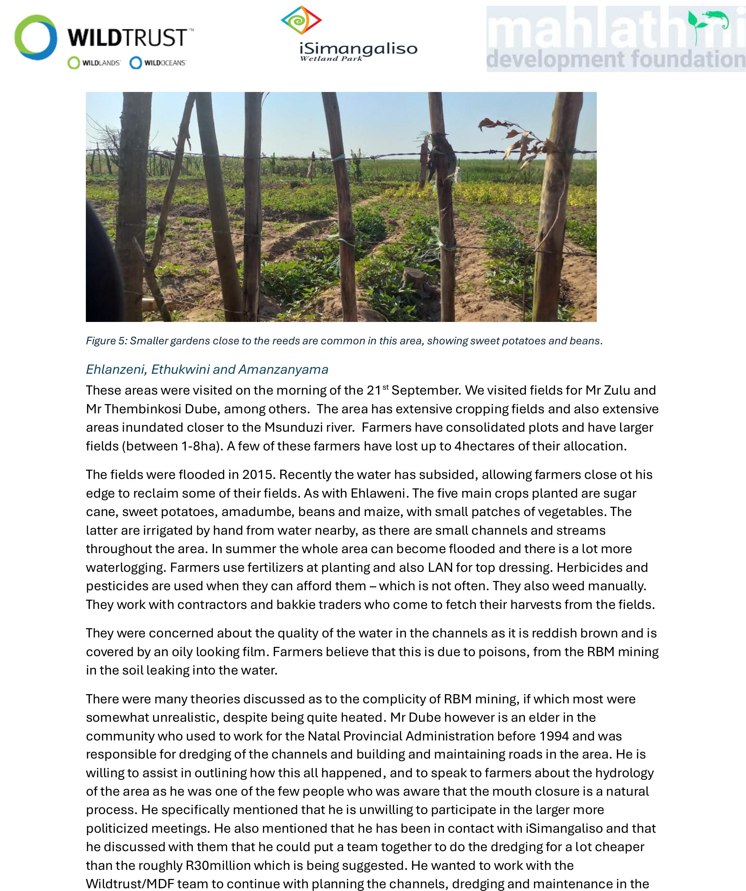
Figure 5: Smaller gardens close to the reeds are common in this area, showing sweet potatoes and beans.
Ehlanzeni, Ethukwini and Amanzanyama
These areas were visited on the morning of the 21st September. We visited elds for Mr Zulu and
Mr Thembinkosi Dube, among others. The area has extensive cropping eldsand also extensive
areas inundated closer to the Msunduzi river. Farmers have consolidated plots and have larger
elds (between 1-8ha). A few of these farmers have lost up to 4hectares of their allocation.
The elds were ooded in 2015. Recently the water has subsided, allowing farmers close ot his
edge to reclaim some of their elds. As with Ehlaweni. The ve main crops planted are sugar
cane, sweet potatoes, amadumbe, beans and maize, with small patches of vegetables. The
latter are irrigated by hand from water nearby, as there are small channels and streams
throughout the area. In summer the wholearea can become ooded and there is a lot more
waterlogging. Farmers use fertilizers at planting and also LAN for top dressing. Herbicides and
pesticides are used when they can aord them – which is not often. They also weed manually.
They work with contractors and bakkie traders who come to fetch their harvests from the elds.
They were concerned about the quality of the water in the channels as it is reddish brown and is
covered by an oily looking lm. Farmers believe that this is due to poisons, from the RBM mining
in the soil leaking into the water.
There were many theories discussed as to the complicity of RBM mining, if which most were
somewhat unrealistic, despite being quite heated. Mr Dube however is an elder in the
community who used to work for the Natal Provincial Administration before 1994 and was
responsible for dredging of the channels and building and maintaining roads in the area. He is
willing to assist in outlining how this all happened, and to speak to farmers about the hydrology
of the area as he was one of the few people who was aware that the mouth closure is a natural
process. He specically mentioned that he is unwilling to participate in the larger more
politicized meetings. He also mentioned that he has been in contact with iSimangaliso and that
he discussed with them that he could put a team together to do the dredging for a lot cheaper
than the roughly R30million which is being suggested. He wanted to work with the
Wildtrust/MDF team to continue with planning the channels, dredging and maintenance in the

elds as opening the mouth in and of itself will not have the desired impact of managing water
on the oodplain that the other farmers are expecting.
Figure 6:Left: A view of sugarcane elds, bordered with bananas, typical in the oodplain and Right: Sugarcane being
harvested and loaded by the contractor.
Figure 7: Left: A plot of amadumbe planted closer to the reeds, which indicate the inundated area. Right: These elds
are expanded bit by bit as the water has slowly been subsiding. The farmers pointing out the edge of the reeds. Here
they were hoping to be provided with pumping and piping to pump water from this area to the higher lying areas.
Figure 8: A typical ploughed eld and a close up of the soil, which when dry is incredibly hard
Figure 9: Left: A view of the reddish-brown water with lm on top, common in the small channels in the area and
Right: A patch of wetland reeds – these are generally quite small but dotted throughout the landscape.

Figure 10: An example of a maize plot in the area. Growth is surprisingly good for the quality of the soil. In addition this
maize was planted during winter, which provides a denite market advantage, as this isn’t possible anywhere else in
South Africa.
Closing remarks and way forward
Farmers have asked for irrigation options, fencing and dredging of the Msunduzi mouth. They are
open to trying out new ideas and crops, such as mulching, conservation agriculture, fodder
crops and possibly rice, but warned that people on these plains have been doing the same thing
for a long time and would be reluctant to change.
They do not particularly like the idea of consciously cultivating and leaving patches of wetland in
this area, and given the larger land holdings of some of the farmers, will also want to continue
ploughing. There isn’t a strong understanding among the farmers of the importance of the
channels and wetlands in managing the water in the area. For them the channels are there only
to lead water away from their elds.
The soils are typical of wetland soils that have been cultivated too much – heavy and
structureless, leading to incredible hardness when dry, plough pans and a tendency towards
water logging when wet. These farmers have a system of managing these characteristics to still
produce reasonable crops, but in the long term this is very destructive for the soils themselves.
The system is complex with the water table rising and falling by about 2 metres across seasons,
a situation that opening of the river mouth will alleviate to an extent, but not totally remove.
Next steps include:
-Taking some soil and water samples across the ood plain to ascertain the fertility and
quality of the water
-Comparison of conditionon the oodplain in winter and summer, as well as further
discussions with key informants about channels, patches of natural vegetation, ood
control and scenarios for management. This will need input from agricultural engineers
and hydrologists, as wellas some form of mapping.
-Working with village-based groups of farmers to explore adaptive measures and climate
resilient agriculture practices and to set up a process of experimentation with dierent
options and ideas to improve the management of water and soil on the oodplainas
well as at the homesteads or the smaller communal gardens.
-Continuation of liaison between MDF and the Wildtrust restoration team to allow for
village-based clearing of unwanted gum plantations and recovering these areas as
productive land, through agroforestry systems.