
1
Water Research Commission
Research Project C2019/2020-00150
TOWARDS SUSTAINABLE AND EQUITABLE MANAGEMENT OF WATER RESOURCES:
UNDERSTANDING THE INTERLINKAGES BETWEEN WATER, ECOSYSTEMS AND SOCIETY
THROUGH SPATIAL MAPPING OF ECOSYSTEM SERVICES AND LIVELIHOOD BENEFITS
ANNUAL PROGRESSREPORT
Deliverable 3
Draft submitted
03 August2022

2
Table of content
1
1. Introduction4
1.1 Local context to the study area and connection to existing projects7
1.2 Project aims, outcomes and methods9
2. Assessment of Rainfall and Water Quantity: Progress to date and way forward11
2.1 Rainfall monitor11
2.2 Temperature monitor14
2.3 Streamflow monitor15
2.4 Way forward16
3. Mapping of land use and ecosystem services: Progress to date and wayforward18
3.1 Participatory mapping18
3.2 Way forward25
4. Ecosystem health and functioning mapping: Progress to date and way forward26
4.1 Ezibomvini Village 26
4.2 Costone Village33
4.3 Veld Condition Assessment Report39
4.3.1 Introduction39
4.3.2 Methodology40
4.3.2.1 Site description40
4.3.2.2 Data Collection42
4.3.3 Results44
4.3.3.1 Veld Condition Score45
4.3.3.1.1 Ezibomvini45
4.3.3.1.2 Costone45
4.3.4 Discussion46
4.3.5 Conclusions and Recommendations47
4.4 Way forward48
5. Decisions and social-cultural factors: Progress to date and way forward49
5.1 Decision making in Costone50
5.2 Way forward52
6. Co-learning for sustainable management of land and water: Progress to date and way forward53

3
6.1 Multi-stakeholder engagement53
6.1.1 Multi-stakeholder Adaptive Planning Process Workshop56
6.2 “Water village walks”58
6.3 Spring protection and reticulation59
6.4 E.coli testing60
6.5 EcoChamps60
6.6 Way forward61
7. Annual Reporting63
7.1 Capacity building63
7.1.1 Community63
7.1.2 Organization63
7.1.3 Postgraduate students63
7.2 Knowledge dissemination64
7.3 Work plan65
7.3.1 Timeline of aims65
7.3.2 Deliverables65
7.3.3 Work plan 2022/202366
8. References67
9. Appendices72
Appendix 1.72
Appendix 2.75
Appendix 3.76

4
1. Introduction
Sustainable land management for water, food and ecosystem services is crucial, and particularly
challenging, in degraded, water scarce and natural resources dependent communities, such as the
agricultural villages in the Drakensberg, KwaZulu-Natal. These communities are often disproportionately
impacted by socio-economic hardships, as well as climate variability and weather-related hazards. Such
communities have evolved to deal with environmental and socio-economic disturbances that have shaped
livelihood strategies over generations (Ostrom 1990). Despite decades of initiatives to improve livelihoods
and long-term sustainability of different rural and indigenous communities globally, the successes of
implementation are disparate and seemingly highly context-dependent. Scholars have set out to
investigate success factors in the implementation of these innovations. Increased participation by
stakeholders and community members, co-management and integration of knowledge systems have
been suggested to positively impact the implementation of natural resource management strategies
(Reed et al. 2009, Tengö et al. 2014). It has been found that factors such as power imbalances, poor
income distribution and gender inequities, as well as external and internal disturbances undermine
sustainability, and thus, impede the potential of successful outcomes of community-based natural
resource management strategies (Delgado-Serrano et al. 2018). Repeated evidence that the success of
such innovations are greatly context-dependent, suggests that there is a gap in the understanding of how
the factors that make these smallholder communities contextually different influences the land
management decisions. These communities are largely characterized by their cultural and historical
legacies that shape human-nature relationships within specific cultural and institutional contexts, which
in turn influencecollaboration around these resources (Cockburn et al. 2020). Accounting for the diversity
of social-cultural values, attitudes and understanding of human-nature relationships increases the
context-sensitivity in decision making processes such as land and natural resource management, but is
often overlooked in both science and policy (Muhar et al. 2018). Motivations behind decisions are rooted
in different social-cultural concepts such as worldviews, collective traditions and experiences, beliefs and
values, and play out both in individual and collective decision makingprocesses. While conventional
approaches to natural resource management have taken on technical problem solving processes, many
scholars have recently argued that when drawing on theories and methods from social sciences, the
human dimensions of natural resource management and environmental conservation can be better
understood (Charnley et al. 2017). Although scholars propose frameworks and models to account for
social-cultural concepts to improve the implementation and success of natural resource and land
management, the methodological applications still need to be tested in real cases.
Decisions on natural resources are linked to the property regime of the land being managed and are
commonly categorized into four basic regimes: open access, private property, communal property and
state property (Feeny et al. 1990). This categorization is useful for theoretical analysis but reality is often
more complex with combinations of these regimes; overlapping or conflicting. Communal property, or
common-property, is commonly the dominant property regime of smallholder communities such as those
in focus in this project. In theory, natural resources produced within common-property regimes are
managed by and accessible to a given community, where rights of equal access and use are shared by the

5
community members. However, in practice, access to resources is often not equal. In the South African
context, post-apartheid land tenure reforms ensured the retention of indigenous or customary authority
over communal land by establishing traditional authorities to govern the communities’ land and natural
resources. Rapid socio-economic and political change since the colonial era, which is when the policy of
traditional land tenure was established, has led to inequitable power structures in communities
(Benjaminsen et al. 2006). This is manifested through both formal and informal agreements and kinship
networks that influence community members’ access to land and natural resources. Powerful actors have
an advantage over the impoverished, and women often lack opportunities to control and manage land
(Cousins 2009). The combination of traditional authority over communal land, and national legislation and
policy adds further complexity to the issues of decision making towards long-term sustainability and
resilience in land use management.
Central to addressing the gap of understanding factors influencing decisions made by individuals and
collectives for land and natural resources management, is to investigate the human dimensions,
psychology and mental models around the human-nature relationship. ‘Social-cultural concept’ in this
context is a term used by Muhar et al. (2018), amongst others, to describe the worldviews, collective
traditions and experiences, beliefs, values and attitudes in relation to nature. This concept is often missing
in social-ecological systems research and natural resource management, but it is inherent in decisions
made by individuals or the collective. Having an understanding of what land usesare present and what
management strategies are in place is not sufficient for developing resilient and sustainable co-
management of the resources in smallholder agricultural communities. The multifaceted dynamics
between individual and collective decisions around the use and management of land, water and natural
resources determine the success of the same (Kenter et al. 2016). Therefore, social-cultural concepts that
shape individual and collective decisions must be considered in studies and policies targeted towards long-
term sustainability.
Scientific advancement behind natural resource management is increasingly being created using
sustainability science, social-ecological systems and resilience thinking approaches. Sustainability science
is inherently transdisciplinary, and participatory multi-method approaches are often required to address
the complex human-nature interactions that occur within social-ecological systems (Binder et al. 2013,
Pacheco-Romero et al. 2020). Fundamental to the theory of social-ecological systems is the notion that
feedback between social and ecological systems are interdependent and interact at various spatial and
temporal scales (Guerrero et al. 2018). Although water forms part of a social-ecological system, its
integrating and fundamental characteristics calls for additional emphasis in water focused research and
management. This project uses a novel conceptual framework where the water domain obtains explicit
attention within a social-ecological systems approach (Figure 1.1). This novel approach includes analysis
of components therein, and the feedbacks between, the coupled systems of water, ecosystems and
society. This three-domain framework encompasses and draws on concepts and methods from the
dominating disciplines withineach of the domains separately, as well as the interfaces between the
domains as follows: Water-Society: Sustainable management and use of water resources is the focus of
Integrated Water Resources Management (IWRM), which fundamentally draws on the scientific
understanding of the process-based modelling and the dynamic interactions and feedbacks in coupled

6
human-water systems (socio-hydrology). Ecosystem-Water: There are also interlinkages between the
hydrological processes and the ecosystem functions (two-way dependencies), which is studied within the
field of eco-hydrology. Ecosystem-Society: Societies’ dependency on ecosystems for their well-being and
livelihoods is commonly assessed through the concept of ecosystem services, typically studied using a
social-ecological systems theory.
Figure 1.1. Conceptual framework: coupled water-ecosystem-society systems analysis.
The concept of ecosystem services has moved from predominantly being used for raising public awareness
around biodiversity and habitat conservation, or highlighting the economic values of ecosystems to
society, to become a mainstream paradigm that expresses the diverse sets of benefits and values humans
attribute to human-nature interactions (Peterson et al. 2018). Ecosystem services, being the benefits
humans obtain from interacting with ecosystems, relate to many dimensions of human well-being. These
interactions, between the natural environment, human skills and decisions, technology and
infrastructure, social-cultural organization and institutions, result in the co-production of ecosystem
services (Duraiappah et al. 2014). The resilience of ecosystem services is the capacity of a social-ecological
system to reliably sustain a desired set of ecosystem services, in the face of disturbanceand ongoing
evolution and change. Building resilience of a smallholder agricultural community by focusing on the long-
term provision of ecosystem services is a means to sustain livelihoods and the human well-being of its
inhabitants – a task critical in South Africa, and Africa as a whole. Novel ways of assessing different kinds
of ecosystem services (e.g. provisional, regulating and cultural), as well as linking them to livelihood
strategies, makes the ecosystem service concept particularly useful for exploring human-nature benefits
and values associated with different kinds of land uses, property regimes and social-cultural contexts
(Henriksson Malinga et al. 2018).

7
The research conducted in this project will result in analysis of all the components: water resources and
hydrological processes, ecosystem functions and ecological processes, and people’s and societies’
resource use, management and dependence, as well as cross-domain dynamics. This research will obtain
a comprehensive understanding of not only the natural resource base, but also the socio-economic
benefits the communities obtain from natural resources such as water and ecosystems, within the
communities and in the protected areas nearby. In addition, the social learning approach can provide for
more informed decision making about appropriate adaptive measures to ameliorate negative impacts and
synergise for positive re-enforcements in the social-ecological system. This transdisciplinary research
seeks to generate novel scientific knowledge to guide sustainable management of water resources and
promote equitable development. This, thirddeliverable of the project, coversannual reporting, minutes
from the latest reference group meeting held on May 24th2022, andprogress to date detailing the
multiple activities carried out and the interim findings thereof. The three main activities completed since
the last deliverable is installation of spring protection and reticulation for households in Costone (Aim 5),
a veld assessment in Costone and Ezibomvini (Aim 3), and a multi-stakeholder Adaptive Planning Process
(APP) workshop held in Bergville on June 14th 2022(Aim 5). The report further outlines a work plan and
how the project is meeting its capacity building targets.
1.1 Local context to the study area and connection to existing
projects
The uKhahlamba Drakensberg mountains, KwaZulu-Natal, is a protected area that encompasses
transboundary national parks, game reserves, wilderness areas, and includes declaration of both Ramsar
wetland importance andUNESCO World Heritage Site. These areas are home to rich biodiversity of
endemic and threatened species and habitats, and also host long-term research on grassland
management, soil conservation, and fire regime research. There are distinct fence line effects between
the protected areas and the nearby communities, but the dynamics between the two sides of the fence
in terms of benefits or threats, are not scientifically explored - a gap that this project seeks to address.
Further, the uKhahlamba Drakensbergis a key water source area in South Africa, and provides water to
Gauteng and KwaZulu-Natal. It is of national priority to manage and protect this water source to sustain
supply to the end users. Within the uKhahlamba Drakensberg are the long-term Cathedral Peak research
catchments where extensive, interdisciplinary monitoring and observation is ongoing focused on the
impacts of global environmental change, water, carbon, biodiversity and energy. Research has shown the
rainfall in the Cathedral Peak catchments to be declining, with greater declines evident in the streamflow.
Changes have been shown in the fire regime overtime as well. Beyond this, the research in the catchments
is improving our understanding of hydrological processes. The knowledge that hasbeen generated about
the hydrology/hydro-meteorology of Cathedral Peak nature reserve (CPNR) has benefited the
management of the reserve, regional and national water planning but has not been of direct benefit to
the impoverished, water insecure communitydownstream of the reserve who have a fundamental right
to access the resource. These communities, whose livelihoods largely depend on natural resources and
the land they are managing, receive only small pockets of ad hoc support from provincial Government
Departments such as KZNDARD and DSD and civil society organizations. The Uthukela District Municipality

8
(UTDM) (11 326.12 sq km in extent and has a population of approximately 724 000 people) oversees and
coordinates social and economic development as well as water and health services for the three Local
Municipalities under its jurisdiction (Okhahlamba, Alfred Duma and Inkosi Langalibalele). Due to lack of
resources and other factors, the communities in this area have received little to no support relatedto
water services in their villages, relying instead on very old infrastructure (pre 1994) and undeveloped
water sources (springs and small streams) for their household water needs. There is no focus at all on
agricultural and landscape-based water resource management. Climate change mitigation and adaptation
processes have been limited to training and awareness within municipal structures, to enable
development of environmental management plans. Could the research and monitoring in the CPNR be of
direct benefit and be used in the communities decision making to lessen their water insecurity? Further,
could an understanding of the multiple benefits of high quality water result in opportunities where the
community could be compensated for ensuring that the quality of the water does not significantly decline
as it moves downstream? Research into the dynamic interrelationships between and within the water-
ecosystem-society domains will help explore answers to these questions.
Smallholder farmers in these communities rely heavily on their natural resource base to support their
non-commercial to semi-commercial maize and livestock-based farming systems. Irrigation infrastructure
is virtually non-existent although some individuals use local sources for vegetable production at
household level. Grazing management systems are managed by the traditional authorities and for the
most part is limited to setting annual dates for the cycles of livestock being moved into the mountain
grazing areas (summer) and being allowed back into the village confines (winter). Within this context it is
imperative for the local communities to understand and to start grappling with their resource
management issues and to garner as much support for these processes as they can. Given the very high
levels of poverty in the area, these communities cannot be expected to implement these processes on
their own, but they can go a long way towards jointly setting their priorities of action and undertaking
joint and collaborative activities within theirambit of influence. Mahlathini Development Foundation
(MDF) is a small NGO working in pro-poor agricultural innovation systems who have been supporting
smallholders in 20 villages (~550 direct participants, ~3000 beneficiaries) in the Okhahlamba LM. Local
understanding, planning and implementation of climate smart agroecological practices, linked to local
value chains and economic development can increase people’s adaptive capacity and resilience in the face
of further change. To this end, MDF and their partners have been working with two processes: i) Creating
awareness and appropriate models for implementation of Conservation Agriculture in conjunction with
Grain SA in KZN and the EC (2013 -2019) and ii) Designing and implementation of a decision support
system for smallholder farmer in implementation of a locally appropriate basket of climate smart
agriculture practices in conjunction with the Water Research Commission (2017-2020). The importance
of also including broader natural resource and water management concerns into these processes have
already been noted and initial steps have been taken with the learning groups involved to focus on these
issues; primarily fodder flow and grazing management for livestock and access to and management of
water resources for micro scale irrigation. These processes have provided a strong entry point into these
communities for the exploration and adaptive planning related to integrated water resource management
and ecosystem services that this project undertakes.
9
This research builds on knowledge gained through several projects involving the lead and collaborating
organizations, including the Mahlathini led WRC funded project “Collaborative knowledge creation and
mediation strategies for the dissemination of Water and soil conservation practices and Climate Smart
Agriculture in smallholder farming systems (K5/2719/4), and the project “Establishment of a More Robust
Observation Network to Improve Understanding of Global Change in the Sensitive and Critical Water
Supply Areaof the Drakensberg” (K5/2236), led by the CWRR. The research in this project further relates
to other projects implemented through CWRR and SAEON, as well as outreach activities by Ezemvelo KZN
Wildlife. SAEON is furthermore leading the establishment of the Expanded Freshwater and Terrestrial
Environmental Observation Network (EFTEON). EFTEON is a research infrastructure intended to provide
a platform of well-described and instrumented landscapes to the South African and International research
community, within which our project falls under the Northern Drakensberg Landscape.
UKZN, through the Centre for Water Resources Research, forms part of the African Research Universities
Association (ARUA) Water Centre of Excellence (CoE) along with several other South African and African
Universities. Through the Water CoE, the CWRR is involved with work on catchment restoration and
rehabilitation in a project led by the Institute of Natural Resources (INR) and Umgeni Water in the upper
uMkhomazi. There are thematic synergies between the two projects on sustainable management of land
and water resources, and cross-learning and sharing of knowledge will occur between the two project
teams.Furthermore, the study area of this projects falls within the South African National Biodiversity
Institute (SANBI) Thukela Catchment Living Catchment Project under which collaboration and co-learning
is taking place within a multi-stakeholder engagement process. Recently, the INR, MDF, and CWRR-UKZN
haveentered into a collaboration with the WWFto establish a Strategic Water Source Partnership (SWSP)
for the Northern Drakensberg with particular focus on the upper uThukela. The SWSP will implement work
related toclimate resilience agricultureand thecontrol of alien invasive plantsas well as supporting
stakeholder engagement.
1.2 Project aims, outcomesand methods
The aims of the project are as follows:
●Aim 1. To assess and quantify changes in rainfall patterns and water quantity over time to
inform communities’ decision making.
●Aim 2. To develop a transdisciplinary social-ecological GIS support tool for decision making and
management of water and natural resources and link land uses with ecosystem services and
livelihoods.
●Aim 3. To survey ecosystem health and functioning including biodiversity of community land
based on the needs of the communities for their ecosystem services and livelihoods.
●Aim 4. To improve the understanding of local decision making and resource use and
management and identify the social-cultural factors that influence decisions.
●Aim 5. To design and test a framework for supporting innovation and decision making for
sustainable resource use management and improved livelihood opportunities.

10
The five aims are corresponding to the five components, described in short as; 1. Rainfall and water
quantity, 2. Map layers of land use, ecosystem services and livelihoods, 3. Ecosystem health and
functioning, 4. Decisions and social-cultural factors, and 5. Co-learning for sustainable management of
land and water. Figure 1.2 provides an overview of how the aims correspond with the expected outcomes
and methods. The progress and methods are further outlined and clarified in sections 2-6.
Figure 1.2. Overview of the five aims and how they relate to the outcomes and methods.

11
2. Assessment of Rainfall and Water Quantity: Progress to
date and way forward
The first aim of this project is:
-To assess and quantify changes in rainfall patterns and water quantity over time to inform
communities’ decision-making.
This aim relates to outcome 1.1 which focuses on understanding of the water resource (changes of water
quality, quantity, streamflow, recharge potential, sediment load). To achieve this aim, the
hydroclimatological data from the Cathedral Peak research catchments was assessed to determine any
changes over time that have occurred.
The Cathedral Peak Research catchments were established in 1945 for the purpose of investigating the
influence of land management treatments on streamflow response. The catchments were highly
influential in informing water policy in South Africa, particularly as it relates to afforestation. In 1995 (and
earlier at some stations), due to a lack of funding, monitoring ceased in the Cathedral Peak catchments.
Recognising the value of the historical data from the catchments for assessing long term change, the
SAEON Grasslands-Wetlands-Forests node became actively involved in the landscape in 2011, and over
time intensified the monitoring the catchment and formally registering the Cathedral Peak research
catchments as a Long Term Ecological Research site.
An updated assessment of the hydroclimatological data is presented below. The long term data including
the historical period is presented, and qualitative comparisons drawn at this stage. Each month, SAEON
releases a rainfall and streamflow monitor for the catchments, the latest versionavailable of this is
included. The current hydrological season is not yet completed, and will only be presented in the next
deliverable.
2.1 Rainfall monitor
The SAEON Grasslands node has monitored rainfall for a full nine (2012/2013 - 2020/2021) hydrological
years (Oct - Sept) in the Cathedral Peak catchments. The primary weather station site, both now and in
the historical period, is the Mike’s Pass weather station. The annual rainfall totals for the hydrological
years that have been monitored (Figure 2.1) have been lower than the historical mean (1 392 mm) taken
as the period 1951 – 1980 except for the 2020 hydrological year. The mean was taken for this period as
the confidence in the data was high. The gap in the data between 1990 and 2012 at the Mike’s Pass station
limits the analyses. Thus, using the SAWS station at the Cathedral Peak hotel, the Mike’s Pass station was
patched for the period 1990 to 2011. The differences in altitude, localised rainfall events characteristic of
the area, and only having one gauge available to patch from, implies that the patching is not ideal and is
associated with high uncertainty. The annual rainfall anomalies from the 1951– 1980 mean for the full

12
period including patched data are shown in Figure 2.2. Given the short current record period and the
concerns about the quality of the patched record, no trend analysis has been undertaken.
Figure 2.1: Annual (hydrological years) rainfall anomaly for the Mike’s Pass meteorological station
During the drought experienced in the early 1980’s (1979 - 1984), the lowest annual rainfall total
experienced was 792 mm in 1984, and relative to the historical mean the total deviation for the six-year
period was 1 677 mm. During the more recent drought (2014 - 2019), the lowest annual rainfall total was
765 mm in 2018, the lowest annual rainfall total on record for the site. Although the difference between
the total in 1984 and that in 2018 isrelatively small, it is the total deviation for the more recent six-year
period of 2 120 mm that indicates the severity of the more recent drought relative to the 1980’s drought.
Further to this, the more recent drought comes on the back of two years of below average rainfall (2012
and 2013). The most recent hydrological year (Oct 2020 – Sept 2021) was wetter than the historical
average by 200 mm. To provide context, the standard deviation of the historical annual rainfall is 206 mm,
thus although wetter the most recent year was within one standard deviation of the historical annual
rainfall.
The monthly rainfall monitor to the end of December 2021 is provided in Figure 2.3. The above average
rainfall for the 2020/2021 hydrological year is due to the above average monthly rainfall at the start of
the 2020/2021 summer season. The winter months of the 2020/2021 were drier than average, as has
been noted for the other hydrological years since the start of the contemporary record at the site.

13
Figure 2.2: Annual (hydrological years) rainfall anomaly for the Mike’s Pass meteorological station for the
full period 1949 – 2020 using a combination of in-situ gauged data and infilled data
Figure 2.3: Monthly rainfall anomaly for the Mike’s Pass meteorological station

14
2.2 Temperaturemonitor
The mean annual temperature at the Mike’s Pass weather station since monitoring resumed in 2012 has
been above the historical (1951 - 1980) mean average temperature, and has been greater than the mean
by more than 0.5 ⁰C each year with 2015 and 2019 being more than 1.5 ⁰C warmer than the historical
mean average temperature (Figure 2.4).
The monthly mean temperature anomaly for the current period is shown in Figure 2.5. The monthly mean
temperature has generally been greater than the historical mean of the monthly average temperature,
especially during the winter months. Interestingly, the month of October in the current period has often
been colder than the historical mean for October (Figure 2.5).
Figure 2.4: Annual mean temperature anomaly for the Mike’s Pass meteorological station

15
Figure 2.5: Monthly mean temperature anomaly for the Mike’s Pass meteorological station
2.3 Streamflow monitor
Majozi (2017) showed a declining trend in the streamflows for Cathedral Peak, Catchment IV from 1950
to 1995. With the current streamflow period becoming longer, with a full seven hydrological years of
streamflow data now available for the current period an analysis of the trends in flow will be undertaken
in this project in the nextyear.
As expected, the streamflow responses lag the rainfall experienced as they are moderated by the soil and
groundwater stores. The annual streamflow anomaly for the historical and current record period relative
to the 1961 - 1987 mean for Catchment VI, Cathedral Peak is shown in Figure 2.6. The lowest annual
streamflow on record was experienced in the hydrological year of 2018, in alignment with the lowest
annual rainfall total. During the current meteorological drought period, the streamflows in 2016and 2017
were above normal. The reasoning for this is related to the pattern of the rainfall experienced, the
unusually wet July of 2016 and the February 2017 which was 200 mm wetter than the historical average
for February. In alignment with the above average rainfall during the 2020/2021 hydrological year, the
streamflow was above normal.
The monthly streamflow anomaly for the current period (Figure 2.7) reflects the same pattern as the
annual streamflow graph, showing the influence of the wet July 2016 and February 2017 on the flows. As

16
well as the influence of the wet start to the summer rainfall season of 2020/2021, where the rainfall in
October 2020 to January 2021 was above normal resulting in the above normal flows in January and
February 2021.
Figure 2.6: Annual (hydrological years) streamflow anomaly for Catchment VI, Cathedral Peak
2.4 Way forward
The temperature, rainfall and streamflow monitors for the Cathedral Peak area will continue to be
produced on a monthly basis. How the information is prepared for the communities will be altered
through consultation with the project team and community learning groups. In addition, the data from
the MDF weather stations in the larger study area will be included and assessed.
Further indices to describethe patterns in the climate and associated variables such as fire risk, have been
produced and are being considered as possible inclusions based on community interests. The ACRU
agrohydrological model has been configured for the catchment area with broad information. The
information gathered through the mapping exercise (Section 4) will be used to improve the model
configuration in the next two months.

17
Figure 2.7: Monthly streamflow anomaly for Catchment VI, Cathedral Peak

18
3. Mapping of land use and ecosystem services: Progress to
date and wayforward
The second aim of this project is:
-To develop a transdisciplinary social-ecological GIS support tool for decision making and
management of water and natural resources and link land uses with ecosystem services and
livelihoods.
This aim relates to outcomes 2.1-2.5 as follows:
Outcome 2.1: Map of locally redefined land use, “social-ecological patches”
Outcome 2.2: Map of ecosystem services and livelihoods
Outcome 2.3: Understanding of gaps and priorities
Outcome 2.4: Overview of current management strategies and limitations
Outcome 2.5: Identification of power dynamics and inequitable access
To achieve this aim a series of maps is being created into a comprehensive GIS support tool for decision
making, compiling data from all the three domains water, ecosystem and society. These maps will provide
opportunities for multi-dimensional spatial analysis for identification of multi- and transdisciplinary
feedbacks, synergies and trade-offs between components of the three domains. Available land use/land
cover maps are typically produced at course resolutions, based on satellite imagery, secondary data and
assumptions. These maps are useful for large-scale landscape and development planning and regional
land management. However, in order to create more locally relevant land use maps for local decision-
making, verification, ground-truthing and re-classification of land uses are needed. The methods being
used in order to achieve this aim are a combination of methods drawing from multiple disciplines, across
natural, social and sustainability sciences. These include GIS, participatory mapping with transect/village
walks, focus-group discussions. COVID19 restrictions have resulted in a delay in fieldwork required for the
maps, however some progress has taken place and interim findings are being presented here and in
section 4.
3.1 Participatory mapping
Three participatory mapping exercises have been taken place in each of the communities Ezibomvini and
Costone; one group with women, one with men and one with decision makers (i.e. people in the
communities involved in decision making processes such as grazing or water committees), between
September 2021 and January 2022. Motives for having separate groups with men and womenare two-
fold; firstly, the differential use and dependencies of resources and parts of the landscapes between men

19
and women are important to understand and captured. Gendered activities such as livestock herding
carried out by men, and fetching water thatis usually women’s responsibilities, are enabled to be
discussed at more depth if the groups are separated. Secondly, persistent power dynamics between men
and women can affect the confidence and freedom to express ones views and perceptions by women in
the presence of men.
High-resolution satellite images sourced from Google Earth were used in order for the workshop
participants to mark and identify relevant places, land uses, ecosystem services and features in their
community landscapes. These images were printed out on A3 papers and mounted on a flip chart and the
questions/discussion followed a guide found in Appendix 1. The boundaries that were marked out by the
community leaders and members during the inception field visit to the communities were confirmed or
revised as a start.
Table 3.1 (Costone) and Table 3.2 (Ezibomvini) provide overviews of some of the reflections and
comments that were gathered during the workshops, as well as what features were discussed and marked
in the maps. Processing of all the rich qualitative and GIS data that was collected during these workshops
are underway. The information presented below should therefore be considered only parts of the
findings. Figure 3.1 shows an example of a map being created during the workshop with men in Costone,
and Figure 3.2 the initial data processing into a google earth satellite image. Figure 3.3 similarly shows an
example of a map created during the workshop with women in Ezibomvini, and Figure 3.4 the initial data
processing into a google earth satellite image.
Table 3.1 A selection of reflections and comments gathered during three participatory workshops in
Costone, with women, men and decision-makers respectively.
Step
Women (n=9)
Men (n=8)
Decision makers (n=7)
Identify natural
resources and land
uses
Livestock also graze within the
homestead
No specific area allocated as
cemetery but bury around their
homestead
No specific place for
medicinal plants collection -
everywhere on the landscape
Many do cropping
No specific place for medicinal
plants collection - everywhere
on the landscape
Thatch grass is only found along
the edges of the cropping fields
but when fields are cultivated
Identify areas of
inadequate supply
Some women used to collect
firewood from KwaKhanyile
forest but restricted now
The small dam is silted - sand
and plastics. If the dam could
be rehabilitated, it can help in
irrigating their cropping fields
The road to ehlathini
elimpunga is eroded, they can
no longer go and collect
firewoods, poles for funerals
and construction
They only get water from
springs and no taps
They mark an area no longer
used for livestock grazing
because of stock theft
Several degraded areas were
marked on the map
Road to Ehlathini elimpunga is
eroded and dongas formed. It is
difficult to get to the cropping
field near ihlithi elimpunga
The old road is no longer
working because of soil and gully

20
erosion and a wetland has
formed around that area.
The road that goes up to the
mountain on the way to
KwaMnukwa is eroded and the
oxes can't get upto load the
poles or ungcuba.
Water sources that no longer
have water or in short supply
were noted
Identify restricted
areas and unequal
access to resources
No restricted place within their
surrounding
Women are only restricted in
the kraal at their household as
part of the culture
The forest called UMntwana
and KwaKhanyile are restricted
for only collecting poles that
are used in funerals
The forest called UMntwana
is restricted for only collecting
poles that are used in
funerals.
Livestock grazing iscommunal
The forest called UMntwana is
restricted. Only for collecting
poles for funerals.
Priorities/needs of
community on land
use and natural
resources
Water is essential to them
Fence the cropping fields
Fence cropping area
Maintain the springs
Some of the springs are
drying up on winter and dug
out in summer - e.g.
umthombo ngakwa Miya
nakwaMabaso
The need a cropping field area to
be fenced to prevent livestock
and begin to cultivate again
They also want a fence along the
main road to prevent livestock
from entering the homestead
Suggestions for
managing land and
water resources
sustainably and
equitable
Need policy to manage
resources equally and
sustainably
Check how much water is
available and protect it
Install a tank at the top of the
mountain and connect a pipe
that provides water, big
enough for everyone to get
water.
No one should collect water for
washing clothes but instead do
the laundry by the river
Elect one person to open and
close the tank at agreed times
Work together
Community members should
be an eye to everything
Community should work
together. Decisions should be
taken together. Agree together
as community on things that
help them
the community will sit down and
have a discussion about
protecting and managing their
resources and come out with
laws
Additional
reflections
Women know their area very
well, especially places where
they collect firewoods, washing
clothes and water sources
(springs)
They are afraid of entering the
intact forest called Umntwana
omkhulu
Grazing areas, dip, forest,
cropping fields identified as
important to men.
Umntwana omkhulu
nomncane are
indigenous/natural forest
Empungeni is gumtree
plantation
The contractor that put fence
in the area separated the
cropping fields and
This group was able to identify
many degraded areas such as
eroded roads

21
homesteads but placed the
fence incorrectly.
There is an area where they
collect medicinal plants but
restricted and outside their
boundary.
Figure 3.1 An example of a map being created during the participatory workshop with men in Costone.

22
Figure 3.2 Initial data processing from participatory mapping workshop with decision makers in Costone.
Work still in progress thus missing features and labels.
Table 3.2 A selection of reflections and comments gathered during three participatory workshops in
Ezibomvini, with women, men and decision-makers respectively.
Step
Women (n=6)
Men (n=7)
Decision makers (n=17)
Identify natural resources
and land uses
No wetland - dried out and people
have built houses there
The mountainous area called
Inyunyana is used as a grazing area
Thatch grass is found along the edges
of cultivated fields within the
homestead
Collect umlahlankosi at Inyunyana. no
women allowed to collect it, only men
or boys
Cropping fields are only found along
the homestead together with
vegetable gardens
Notes not yet
available
Livestock graze everywhere within
the community
Wildfood includes uMdolofiya,
umkhwebezane, amakhikhizelo,
ishaqa, amakamuketshe
No proper firewood but they do
collect inhlaba,uhalabhamo,
isiqhapheyane, ugagane,
intozwane, isitibhili
Buy poles from SAPPI. Thatch grass
is scarce and only get it when
cropping fields are cultivated.
They said no recreational area
Used to go to embhengeni/

23
nyanyane area to pray for rain in
the old days.
Collect amanqatha (incansi
eluhlaza) for cultural uses.
Collect imbomvu for painting wall.
Collect different type of building
sand along the river.
Use land within their homestead to
make mudbricks.
Identify areas of inadequate
supply
Most naturalwater sources are no
longer available
Built infrastructure such as tanks are
no longer working because pipes are
cut off
Notes not yet
available
Used to get bee honey in the area
called Engosisi but has been closed
by rocks
Some natural water sources
marked on the map are no longer
available
Some medicinal plants are no
longer found because of lack of
management such as following
rules of collecting medicinal plants.
Identify restricted areas and
unequal access to resources
None
Notes not yet
available
Norestricted area. e.g livestock are
free to graze or move around
neighbours
Priorities/needs of
community on land use and
natural resources
Water - protect the water sources.
Get Jojo tanks
Notes not yet
available
Protect water source, grazing areas
and preserve medicinal plants.
Suggestions for managing
land and water resources
sustainably and equitable
Get Jojo tanks installed at homestead
to harvest rain water.
Get jojo tank installed and a tap next
to the spring. Connect a pipe from a
tank for everyone to get water but
make sure the area is protected.
Provide fences to prevent livestock
from reaching the cropping fields.
Notes not yet
available
Work together. Be an eye of the
community. Be a good example of
the community.
Additional reflections
Notesnot yet
available
The participants seem to be very
interested in making use of what
they have. Can do thing by
themselves if they get support.
They no longer want to wait for
government to assist them.
The group was confused about the
boundary.
Rules suchas collecting medicinal
plants were lost because of lack of
traditional leadership. e.g. time of
harvesting and ploughing.

24
Figure 3.3. An example of a map being created during the participatory workshop with women in
Ezibombini.

25
Figure 3.4 Initial data processing from participatory mapping workshop with women in Ezibomvini. Work
still in progress thus missing features and labels.
3.2 Way forward
The data and information processed from the participatory mapping workshops will be completed during
July and August2022. Additional data that will feed in to aim 2 will be collected during community walks,
focus group discussions and in-depth interviews with key informants.
Social-ecological patches will be identified, which is spatial sub-units of land use that encompass the
natural resource base, vegetation, property regime (individual and communal land access) and the socio-
economic dependency and benefits in terms of ecosystem services and livelihoods opportunities that
people using the land obtain or seek to obtain (Sinare et al. 2016). This information will be layered with
GIS data gathered under aim 3 (section 4). These maps will be presented and discussed with the
communities during the series of co-learning workshops being planned under aim 5 (section 6).

26
4. Ecosystem health and functioning mapping: Progress to date
and way forward
To contribute to Aim 3 of the project viz. “To survey ecosystem health and functioning including
biodiversity of community land based on the needs of the communities for their ecosystem services and
livelihoods”, field and desktop surveys are to be used to develop maps of the ecosystem condition for
both the Ezibomvini and Costone villages. The section of the deliverable reports on the progress towards
the development ofmaps of ecosystem condition.
The maps of ecosystem condition will be informed by three aspects,
➢field based surveys which focus on water sources, including springs and wetlands, erosion and
invasive alien species and woody encroachment
➢use of land use andland cover satellite imagery and terrain maps, and
➢Veld Condition Assessments (VCA)
Due to national COVID19 lockdown restrictions and those imposed by the University on undertaking work
in community areas, the surveys were delayed. The field based surveysin both villages were conducted
between August and November 2021. However, the field component of the veld condition assessments
were only conducted in late January 2022 with the plant identifications and analyses continuing into
February 2022.
Thus, the field based surveys using GPS which mapped the water sources, including springs and wetlands,
erosion and invasive alien species and woody encroachment are reported in this Deliverable for each
village. The maps and discussions presented here are interim and will be finalised following the
completion of all aspects of the veld condition assessment. Boundaries for the villages were determined
with the community members during activities described in section 2. The field surveys considered areas
outside of the village boundaries to ensure that any upstream factors affecting the ecosystem condition
were included.
4.1 Ezibomvini Village
Within the village boundary demarcated by the village members there are two distinct areas, a higher
lying upper area which consists predominantly of grassland, woody vegetation and wetlands and the
lower lying area which is dominated by homesteads, agriculture and small grassland blocks (Figure 8).
Four streams run through the Ezimbomvini village and feed into the Lindequespruit River. The field survey
was undertaken for the catchment areas of two of the streams, and focused on the higher lying areas
(Figure 4.1). The lower section consists of homesteads, agricultural zones and grasslands. A notable,
unique and rare botanical feature of the area is a natural Aloe hybrid population betweenA.arborescens
and A.marlothii.

27
Figure 4.1: Ezibomvini village boundary with the streams, wetlands and springs and locations of E.Coli
tests, as well as the known points of water extraction and use.
Several springs are used for drinking water by the village. These springs are mainly in the higher lying area,
near the rivers (Figure 4.1). The water is mainly collected by buckets. The springs are also used by cattle.
The springs, however, are not high yielding. Water sources are limited, and are a significant concern in
this village. The water collected from the rivers is used in household cleaning, washing clothes and
bathing. Cattle, goats, pigs and ducks drink from several points along the river (Figure 4.1). The lower
regions of the streams are subjected to dumping of building rubble, household refuse, glass bottles and
nappies. The presence of the above mentioned will affect water quality. The presence of E.coli (Escherichia
coli) was tested at several points along both streams, with samples either testing positive for E. coli or
Coliforms Bacteria (Figure 4.2). These tests are going to be repeated as they were a single snapshot in
time. However, given the dependence of the village on these watersources the results were concerning.
Areas which appear to be wetlands were noted adjacent and near to the river systems (Figure 4.1). These
areas were wet in the dry season and had vegetation characteristic of frequently saturated areas. No

28
formal delineation of the wetlands was undertaken. The condition of the wetlands identified varied from
severely impacted (Figures 4.3 and 4.4) to near-pristine, however, the majority of the wetlands were
degraded and the functioning impaired with significant erosion present. Further, the riparian areas of the
streams have been eroded (Figure 4.4), in some areas significantly with deep gullies having formed. The
impacts on the wetlands and riparian areas noted in the field included cattle grazing, erosion, invasive
alien species and clay harvesting for brick making. The degradation of the wetland and riparian areas in
the upper higher lying areas of the village was noted as a significant concern. It is likely that the extent of
the degradation has already negatively impacted the water quantity and quality in the streams, with the
risk that further degradation could have significant negative impacts.
Figure 4.2. Results from the E.coli testing. A green colour indicates the sample is positive for E.coli, a yellow
sample indicates Coliforms Bacteria. The locations the samples were taken from are indicated on the map.
Figure 4.3. A Poplar stand growing within the wetland area adjacent to a stream (left) and an example of
the gully erosion in the catchment areas (right).

29
Figure 4.4. A wetland area where clay has been harvested from to be made into bricks.
To illustrate the extent of impact and concern of potential impacts going forward interventions should be
put in place. A concrete water tank with furthertanks downslope were noted during the mapping survey.
Community members were asked about the tanks, from their knowledge and memory the tanks were
installed by the Department of Agriculture and supplied water to various households and gravity fed
downslope areas through pipes. A pipe from the tank was pointed out by the community and it was noted
that it no longer supplied water. It was understood that the tanks used to be fed by a spring with a v-box
protection high up in the catchment area. On visiting the site of the supposed spring site, significant
erosion was found, no spring or evidence of it could be found and it appeared as if the v-box had collapsed
years prior due to the significant erosion.
The areas of erosion were not limited to the riparian areas, with erosion mapped across the higher lying
areas of the village (Figure 4.5). Deep gullies have been formed which, in some cases, have been invaded
by alien species (Figure 4.6). Scattered rocky areas occur in the high lying areas of the village. An extensive
network of cattle paths was noted in the invaded, rocky areas. This is presumably caused by herds of
goats. These rocky areas have been invaded by woody vegetation (Figure 4.7), mainly Lantana camara
(Lantana) and Aloe marlothii(Mountain Aloe). Lantana is one of the worst weeds in the world and category
1b invasive species in South Africa. The rocks provide a favourable micro habitat for Lantanaand Aloeto
flourish. They provide shelter from veld fires, shade, and increased moisture. Field observations of the
Mountain Aloe show all age groups present in the population. The opposite is found for Lantana which
mainly comprises of mature adults. The old aloe leaves and dead lantana branches are collected for
making fires. In this community, Lantana is dispersed by frugivorous birds defecating on the rocks.
Although the condition of the veld is yet to be determined, it was noted that the Lantana encroaches into
and competes with the grassland species.
30
Figure 4.5. The areas of significant erosionin the Ezibomvini Community.

31
Figure 4.6. Images of erosion within the Ezimbovini village.
A further invasive species noted and mapped wasPopulus alba (silver-leaf poplar). The Poplar, a category
2 invader, was commonly seen growing along or within the river. The Poplar has been planted and is
maintained by the community as it is used for wooden poles for building and fencing. They have a colonial
growth form and create dense stands, and given the deep rooted nature and greater biomass, a higher
water use than the grassland species they replaced. The water use of Populus albahas not been
determined in South African conditions, however, Ntshidi et al. (2018) found Populus canescensto have
a conservative impact on water use in the Western Cape due to the deciduous nature of the tree which
shortens the transpiration length during the year unlike the Acacia, Pinusand Eucalyptusinvasive species.
Ntshidi et al. (2018) suggested a low priority of Populus canescensin the alien clearing programs. As
Populus canescensis considered a hybrid of Populus alba, in the absence of field based measurements,
the water use of these trees could be considered a low priority. It has also been found growing in Costone.
Historical imagery will be used to determine whetherthe extent of the alien species invasion has increased
over time or remained relatively constant during the next stages of the map development. Growing within

32
fallow maize fields and verges of dirt roads is Lespedeza cuneata. This leguminous species was introduced
to South Africa as a forage species. However, it has the potential to become a serious invasive weed due
to the seed banks which can remain for decades. It has been declared a serious weed in several USA states
where it was introduced for erosioncontrol and proved to be an extremely aggressive invader in open
areas (https://www.cabi.org/isc/datasheet/20616387).Further surveys have indicated the potential
invader is more widespread that initially thought. The species has been highlighted by the Enviro Champ
for removal.
Figure 4.7. The woody vegetation components in the upper region of the community.

33
4.2 Costone Village
The Costone village is characterized by a high altitude mountain boundary, three river systems, a large
wetland in the community area and grasslands. The high altitude regions contain springs that feed the
three rivers the flow down through the homestead areas (Figure 4.8). The steep mountain slopes are
characterized by a rich diversity of indigenous trees. The lower regions are covered by grasslands,
wetlands, homesteads and agricultural zones. As the village area is substantially larger than the
Ezimbomvini village, the full catchment areas of the rivers could not be walked. Thus, key areas were
identified prior to the field survey.
In contrast to the Ezimbomvini village, Costone has a number of water sources. A borehole has recently
been drilled in the village, with a pump and tanks installed that supply water to asector of the village.
There is a borehole with a hand pump above the homestead area, near to which there is a protected
spring (v-box) that feeds into two JoJo tanks from which community members collect water (a significant
distance from any houses however). A further key feature with regards to water, is a large wetland in the
lower homestead area of the village (Figure 4.9). There are three springs in this area that, at the end of
the dry season, had fair yield. Drinking water is collected from these springs, however, they are not
protected thus are used by cattle for drinking as well. A wetland assessment and delineation was not
done. However, from the field survey it was noted that the majority of the wetland vegetation remains
intact. A portion is used for agriculture during dry years and left fallow in wet years. Cattle are allowed to
graze within the wetland. There is a good flow of water exiting the wetland into the river. The importance
of protecting this wetland and building spring protections to ensure a sustainable water source for the
community was evident. Two sets of E.Colitests were undertaken on the springs and flow exiting the
wetland (Figure 4.10). The first tests were taken at two of the springs in the wetland (Points D and E in
Figure 4.9) and at the flow exit from the wetland (Point F in Figure 4.9). The second set were taken at the
three springs and the exit of the wetland. During October a spring tested positive forE.coliwhile in
November the flow from the exit of the wetland was positive. As these are points used for drinking water
collection, protection is needed.
Upstream of the larger wetland, a smaller wetland was noted (Figure 4.9). The smaller wetland was
significantly degraded with the impacts noted being overgrazing, clay harvesting for bricks and agriculture.
There was no flow exiting this wetland.

34
Figure 4.8. Costone Village boundary with rivers, springs and points of water extraction shown as well as
locations of sampling for E.Coli

35
Figure 4.9: Lower portion of Costone Village with rivers, springs and points of water extraction shown as
well as locations of sampling for E.Coli, erosion areas and invasive species.
Other water features identified were springs in the upper areas of the village. Three springs in the high
lying areas surveyed (Figure 4.11), two of the springs (labelled A and B in Figure 4.9) were flowing while
one was dry. The first spring was downstream of an indigenous forest patch. The area immediately below
the spring eye is eroding, with the gullies forming and wattle invasions in these gullies (Figure 4.12). The
impacts noted on the area below the spring are cattle paths and overgrazing. The eye of the second spring
was not observed during the field survey, however, wet areas in the landscape were noted. The area is
characterised by deep continuous grazing lines, and downstream by a mature Podocarpusforest patch.
The third spring, which had the highest discharge, was on a steep slope with wattle invasions on evident
upslope of the spring eye, while significant erosion near and downstream of the spring were noted (Figure

36
4.13). Water samples taken at both flowing springs showed the presence of Coliforms Bacteria (Figure
4.14). These were a snapshot in time after the dry season.
In contrast to the Ezimbomvini village area, the erosion in the Costone village area was primarily limited
to near or adjacent to the streams. Similarly, the extent of the alien invasive species noted was less than
Ezimbomvini. Isolated patches of Poplar trees near to streams were noted. The riparian areas of the
streams in stretches appeared to be in a near-pristine state, and the upper regions of the village area had
a high diversity of indigenous trees and shrubs.
Fig 4.10. E.coli samples taken from points in the wetland on two different dates. A green colour indicates
the sample is positive for E.coli, a yellow sample indicates Coliforms Bacteria. The locations the samples
were taken from are indicated on the map.

37
Figure 4.11: Lower portion of Costone Village with rivers, springs and points of water extraction shown as
well as locations of sampling for E.Coli, erosion areas and invasive species.
Figure 4.12. Erosion downstream of the eye of the first Spring (Spring A)

38
Figure 4.13. Images showing the erosion and presence of wattle near the third Spring (Spring B)
Figure 4.14. E.coli samples taken from springs in the high lying areas in October 2021. A green colour
indicates the sample is positive for E.coli, a yellow sample indicates Coliforms Bacteria. The locationsthe
samples were taken from are indicated on the map.

39
4.3 Veld Condition Assessment Report
4.3.1 Introduction
Rangelands are indigenous vegetation that consists mainly of grasses and shrubs/trees that are grazed
and browsed by livestock or wildlife (Allen et al. 2011). These natural rangelands support livelihoods
through the provision of a range of goods and services. The production of livestock is one of these key
services through intensive ranching on private land or collective ranching on communal lands (Reid et al.
2008). Communal rangelands and their associated residential areas make up 13% of the land surface of
South Africa and support a quarter of the country’s population and half the country’s livestock (Ward et
al. 1998). Concerns havebeen raise about communally grazed rangelands in Africa and similar systems
across the world (Vetter et al.2006). The comparisons between commercial and communal rangelands
have highlighted changes on land degradation and productivity (Todd and Hoffman, 1999). Communal
rangelands are commonly considered overstocked, overgrazed, degraded and unproductive.
Rangeland condition is the health of rangeland functioning in terms of ecological status, resistance to soil
erosion and forage potential for livestock production (Ndandani, 2016). Rangeland degradation is the
continuous loss of species composition and invasion of woody plants (Bosch and Theunissen, 1992).
Communal rangelands condition in South Africa is declining due to poor management, land degradation
and climate change (Hoffman and Ashwell, 2001). In South Africa land degradation is mostly due to
overgrazing and human activities (Vetter, 2003). Overgrazing decreases palatable plants species and
increases in less palatable species (Kgosikoma et al. 2012). Additionally, overgrazing changes plant species
composition, basal cover, diversity, richness and soil moisture while making the rangeland more
susceptible to Invasive Alien Plants (IAP’s) and woody encroachment (Vetter, 2013). There is a direct
correlation between rangeland condition and animal production (Van der Westhuizen et al. 1999) and
therefore these compromised communal systems show a loss of rangeland productivity and poor
livestock performance (Lesoli, 2008).
Overgrazing is seen as the main cause of land degradation in Africa at 243 million hectares (UNEP, 2015),
while in South Africa a quarter of the land owned by the government and rural communities is degraded
(Ndandani, 2016). These communal rangelands are often characterised by high stocking rates and lack of
a grazing management system (Lesoli, 2008). Communal rangelands are a shared resource utilized by the
community members where everyone has equal access to resources the rangeland provides. However,
management decisions are over seen by individual owners (Gxasheka et al. 2017).
Rotational grazing is viewed as a basic grazing management tool in rangeland conservation (Liu et al.
2009). Livestock movements are monitored and controlled to best utilized rangeland resources and
increased livestock production (Gamoun, 2014). Features of a productive rangeland include higher
biomass production with high forage quality, good soil cover and species rich vegetation. On the contrary,
communal productivity is linked to continuous grazing and uncontrolled and unplanned fires (Rutherford
and Powrie, 2013). This management has shown the elimination of favourable vegetation and an increase
establishment of undesirable vegetation (Lesoli, 2008).

40
Species composition is one of the means of studying ecologicalchanges in a rangeland (Malan andvan
Neikerk, 2005). An indicator of rangeland condition is understanding grazing practises and its changes
over time (Abule et al. 2007). Veld Condition Assessment (VCA) is the health of the rangeland in terms of
ecological status, resistance to soil erosion and the potential forage production for continued livestock
production (Trollope et al, 1990). The majority of techniques to determine and monitor veld condition
require an assessment of species composition and an estimate of basal cover for the sample site (Hardy
andTainton, 1993). Furthermore, quantifying biomass production can provide realistic estimates of
stocking rates for sustainable grazing management (Kunst et al.2006). Veld condition assessments is
essential for both commercial and communal rangelands to document the effects of current management
on veld condition and to monitor changes over time and also for evaluating veld condition relative to its
potential in that ecological zone (Hardy et al., 1999). Therefore, this study aims to evaluate two communal
rangelands, Ezibomvini and Costone, in the Northern Drakensberg to understand current health condition
and recommend management tools.
4.3.2 Methodology
4.3.2.1 Site description
The Veld ConditionAssessment was carried at two Villages,Ezibomvini and Costone, communal grazing
lands located in Emmaus, Uthukela District Municipality of KwaZulu-Natal, South Africa. The area is
located at the following coordinates: Ezibomvini - 28°51'50.60"S, 29°23'28.15"E and Costone -
28°55'4.50"S, 29°22'6.67"E with a mean elevation of 900 to 1440 m. Mean annual precipitation 710-
1120mm per year and mean annual temperature 16° C (Mucuna and Rutherford, 2006). The communal
rangelands are shared by members of the communities mentioned and neighbouring communities. The
rangeland is grazed continuously with no restrictions on stocking rates. Cattle and goats are the bulk
grazers whilesheep and horses arepresent in lower abundances. The communal rangeland falls within
two vegetation types: the Drakensberg Foothill Moist Grassland (GS10) and Northern KwaZulu-Natal
Moist Grassland (GS4) as described by Mucuna and Rutherford (2006). The vegetation and landscape is
described as moderately rolling and mountainous with river gorges of drier vegetation types and covered
in forb rich grassland dominated byThemeda triandraand Tristachya leucothrix. Acacia sieberianavar
woodii woodlands are common in valleys and disturbed sites.

41
Table 4.1. The dominant grasses for each vegetation type according to Mucuna and Rutherford (2006).
Northern KwaZulu-Moist Grassland (GS4)
Drakensberg Foothills Moist Grassland(GS10)
Alloteropsis semialata subsp eckloniana, Aristida
congesta, Cynodon dactylon, Digitaria
tricholaenoides, Elionurus
muticus, Eragrostis
patentissima, Eragrostis racemosa, Harpochloa
falx, Hyparrhenia hirta, Themeda triandra, and
Tristachya leucothrix.
Diheteropogon filifolius, Elionurus muticus,
Eragrostis capensis, Eragrostis chloromelas,
Eragrostis curvula, Eragrosti
s plana, Eragrostis
racemosa, Heteropogon contortus, Microchloa
caffra, Monocymbium ceresiiforme, Panicum
natalense, Rendlia altera, Sporobolus africanus,
Themeda triandra, Trachypogon spicatus and
Tristachya leucothrix
Figure 4.15. Study sites of the two villages, Ezibomvini and Costone, indicating the village boundaries and
communal grazing areas.
Ezibomvini
Costone
Costone

42
4.3.2.2 Data Collection
In January 2022, vegetation sampling was carried out at Ezibomzini and Costone villages. At each site four
100m line transects were demarcated across the landscape with 20m between each line transect. Sample
sites occurred within the grazing zones demarcated by the community for each village. Sites selection was
based on vegetation uniformity. We measured grass composition and degree of dominanceusing the
Step-Point. At every 2m intervals the nearest grass species were identified, distance and tuft size
measured.Forbs were excluded as they have a relatively low occurrence in the landscape. If no grasses
are found within a 0.2m radius from the point, it is recorded as bare soil. A 1 x 1 m quadrant was randomly
placed 50 times along the transect to estimate grass and forb cover. Grass species were identified to
species level and placed into ecological status classes using the method of Trollope (1989). The grasses
were grouped into Decreaser species, Increaser I, II and III species and further grouped according to their
life form (annual, perennial, and creeper).
Grass species are classified into four ecological classes based on grazing value, biomass production and
palatability. There ecological classes are recognized as follows:
Decreaser – Tufted and stoloniferous grasses that are abundant in good rangeland and decrease when
over or under grazed. High palatability,high productivity and high grazing value.
Increaser I – Tufted grasses that are abundant in underutilized rangeland. Medium palatability,
intermediate productivity and moderate grazing value.
Increaser II – Tufted and stoloniferous grasses that abundantin overgrazed rangeland. Increase due to
disturbing effecting of overgrazing. Medium to low palatability, high to medium productivity and low
grazing value.
Increaser III –Tufted grasses common in overgrazed rangeland. Species are competitive and difficult to
remove. Unpalatable, low productivity and low grazing value.
The Ecological Score method was used to determine veld condition. The benchmark method cannot be
used as a benchmark veld that would represent best possible botanical composition and cover in relation
to climate could not be found. The Ecological Score is uses data from the grass species composition survey,
the percentage composition of each class is calculated and multiplied with the specific class. The sum of
the values represents an Ecological Index with a maximum on 1000. The veld condition is evaluated using
the following guidelines:
Ecological Score
Veld Condition
0-399
Broadly indicates poor veld
400-600
Broadly indicates moderate veld
601-1000
Indicates good veld

43
Disc Pasture Meter (DPM) (Trollope and Potgieter, 1986, Zambatis et al. 2006) is used to determine the
grass production (fuel load) within most vegetation types. It’s a rapid, non- destructive method to
determine dry mass yield of rangelands. At each transect 50 readings (disc height in cm) were recorded,
200 reading per village, to calculate mean settling height of the disc. The equation of Zambatis et al (2006)
was used to determine grass Biomass (kg/ha):
Kg.ha-1 = [31.7176(0.32181/x)x0.2834]2
where: x = mean disc height in cm of a site
The percentage basal cover of each sample site was obtained by substituting the mean distance and the
mean diameter values into the following regression equation developed by Hardy & Tainton (1993). The
basal cover standards were recommended by Camp and Hardy (1999). The basal covers are: 1-5% critical,
6-10% poor, 11-15% reasonable and 16%+ good to excellent.
Basal cover = 19.8 + 0.39 (D) - 11.87 (logeD) + 0.64 (d) + 2.93 (loged)
D is the distance to the nearest tuft (in cmand rounded to the nearest cm) and d was the tuft diameter
(in cm and rounded to the nearest cm)
Figure 4.16. Images showing the use ofthe Disc Pasture Meter (DPM), quadrat and 100m line transect.
Features to note on the photo on the right, signs ofselective grazing and low sward height.

44
4.3.3 Results
Table 4.2Botanical name, ecological status, perenniality, grazing value and composition score of grass
species at Ezibomvini communal rangeland
Group
Species
Perenniality
Grazing
value
Grazing
value
Score
Ezibomvini
% Score
Decreaser
Themedra triandra
Perennial
High
10
2.5
25
Increaser I
Alloteropsis semialata
Perennial
Average
3
0.5
1.5
Digitaria tricholaenoides
Perennial
High
6
7
42
Tristachya leucothrix
Perennial
High
9
4.5
40.5
Increaser IIa
Heterpogon contortus
Perennial
Average
6
2
12
Increaser IIb
Hyparrhenia hirta
Perennial
Average
6
1
6
Eragrostis plana
Perennial
Low
3
7
21
Eragrostis racemosa
Perennial
Average
2
4
8
Sporobolus Africana
Perennial
Low
3
4
12
Sporobolus pyramidalis
Perennial
Low
3
13.5
40.5
Increaser IIc
Aristida congesta
barbicollis
Perennial
Low
0
2
0
Cyndon dactylon
Creeper
Average
3
0.5
1.5
Paspalum notatum*
Creeper
Average
3
50
150
Urochloa panicoides
Perennial
Low
2
0.5
1
Increase III
Diheteropogon filifolius
Perennial
Low
0
0.5
1
Cymbopogon pospischilii
Perennial
Low
2
0.5
1
Total
100
362
*exotic species
Table 4.3. Botanical name, ecological status, perenniality, grazing value and composition score of grass
species at Costone communal rangeland
Group
Species
Perenniality
Grazing
value
Grazing
value
Score
Costone
% Score
Increaser I
Tristachya leucothrix
Perennial
High
9
1
9
Increaser IIa
Heterpogon contortus
Perennial
Average
6
1
6
Increaser IIb
Eragrostis curvula
Perennial
High
5
7
35
Eragrostis plana
Perennial
Low
3
11.5
34.5
Eragrostis racemosa
Perennial
Average
2
3.5
7
Sporobolus africana
Perennial
Low
3
2.5
7.5

45
Sporobolus pyramidalis
Perennial
Low
3
3
9
Increaser IIc
Paspalum notatum*
Creeper
Average
3
62
186
Increase III
Aristida junciformis
galpinii
Perennial
Low
0
8
0
Diheteropogon filifolius
Perennial
Low
0
0.5
0
Total
100
294
*exotic species
4.3.3.1 Veld Condition Score
The veld condition score for both villages indicate the rangeland is in apoor condition or moderately
degraded.Ezibomvini has a smaller grazing area scored slightly higher than Costone with a larger grazing
area. The villages share a common dominant grassa perennial exotic stoloniferous grass, Paspalum
notatum. P.notatum occurrence is at least 50% for both villages.Referring to the dominant grass species
described by Mucuna and Rutherford (2006) threespecies were present during the survey with Eragrostis
planaand Eragrostis curvulawith a relatively high occurrence,Themedra triandraabsent to low
occurrence and P.notatumas a new dominant exotic rangeland invader.
4.3.3.1.1 Ezibomvini
16 species were recorded with nearly 95% been Increasers (Increaser I- 12%, Increase II – 86% and
Increaser III – 1%). Decreasers isrepresented by Themedra triandraat2.5%. The dominant species are
Paspalum notatum, Sporobolus pyramidalis, Digitaria tricholaenoides,andTristachya leucothrix triandra.
4.3.3.1.2 Costone
10 species were recorded with 100% been increasers (Increaser I - 9%, Increaser II- 90.5% and Increaser
III- 8.5%). Decreasers were absent. The dominant species are Paspalum notatum, Eragrostis plana, Aristida
junciformis galpinii andEragrostis curvula.

46
Figure 4.17. The comparison of aerial cover of grass species, forbs, bare soil and the basal cover of grass
species.
The veld is dominated by grasses and limited forbs. The aerial cover for grasses and forb are similar for
both villages. The basal cover for both villages are also above 16% indicating good to excellent cover.
This is attributed to the dominance of a single grass, P.notatumin both villages. The creeping habitat of
the species has reduced bare ground. The biomass production reveals a similar pattern. Ezibomvini has
a yield of 1342Kg.ha-1 and 1121 Kg.ha-1 for Costone. The low yield is attributed to the dominance of
P.notatumdue to its short sward height and prostate habitat.
4.3.4 Discussion
Overgrazing occurs when animals defoliate grass before ithas had time to recover (Voisin, 1988). This
occurs when livestock remain in an area for too long or return too quickly. Recovery time is important for
grasses to restore roots reserves and asexual and sexual growth. The period required to recovery varies
according to climate, season, and vegetation type and growth habitat. The time frame can vary from 10
days to 90 days or up one year resting (Savory Institute, 2015b). Recovery only occurs in the growing
season and in the absence of grazing. The high abundance of Increaser II species indicate long term
overgrazing at the loss of decreasers species in both villages. The increased abundance of species like
P.notatum, Sporobolus pyramidalisand Eragrostis plana is an indicator the system is fire suppressed.
Selective grazing has been shown to change the structure and species composition of rangelands and
favouring unpalatable species or species with low to average grazing value (Milchunas et al. 1988).
Furthermore, trampling and nutrient enrichment significantly impact species diversity (O’Connor et al.
2010). P.notatumis a highly persistent grass that is able to withstand close defoliation due to its extensive
rhizome network and low growing points and responds well to fertilizer. The competitive adaptationsof
P.notatummake it resistant to selective grazing and benefits from additional nutrients.
0
10
20
30
40
50
60
70
80
90
100
Grass Forbs Bare GroundBasal cover
Ezibomvini
Costone

47
The primary disturbance mechanisms in rangelands are fire and grazing. They work to shape the structure
and composition of the vegetation (Van Wilgen & Scholes1997). Controlled burning is the use of fire to
change rangeland vegetation to favour optimum forage and animal productivity (Trollope and Trollope,
1996). The use of fire is communal rangeland is uncontrolled and influenced by the need to produce fresh
green belt of grass. Livestock will select fresh grass from burnt areas over unburnt areas (Trollope, 1989).
The frequency and time of fires in communal areas often leads to rangeland deterioration. The flush of
green growth at the incorrect time of year is short lived and negatively affects growth vigour. Root
reserves are depleted and favourable species are weakening to the advantage of increaser II species. Fire
intensity refers to the rate of heat released during a fire and determines vegetation recovery. Fire intensity
is directly linked to fuel load. The fuel loads in both systems are low due to the dominance of a P.notatum.
The rangelands cannot support high fire intense burns due to the short and sparse sward blades. Thus
leading to a fire suppressed system.
On a positive note, degraded communal rangelands are resilient and can recover with changes in species
composition and species diversity. Harrison and Shackleton (1999) have shown changes in grass species
composition and grass basal cover with theremoval of high and continuous grazing pressure in communal
rangelands. The resultant changes may represent replacement of species groups that already exist
(Walker et al. 1997). An increase in palatability indigenous species will be favoured over annuals and
unpalatable species. Additionally, the absence showed an increase in the occurrence of palatable species.
The protection from grazing reduced the competitive advantage of undesirable species and lead to a
decline (Frost et al, 1986). This created openings to facilitate recolonization of palatable species.
P.notatumis a strongly stoloniferous, adaptable and long lived species. The grass was able to withstand
intense grazing and dominate species composition due to it to wide network of root reserves which
Strugnell and Pigott (1978) substantiated through root studies. Therefore rotational resting may
encourage perennial species to replace P.notatum.
4.3.5 Conclusions and Recommendations
The communal rangelands in both villages are moderately degraded and dominated by grass species with
an average palatability and low grazing value. The continuous overgrazing has lead to a single species
dominating the rangeland. Fire as a tool for regeneration is misunderstood. These disturbances have
changed the species composition and richness.The use of fire needs tobe carefully planned and rest
periods where appropriate need to be incorporated after its use. Controlledburning must be integrated
with other grazing management techniques to gain the full benefits.Degraded communal rangelands are
resilient and can recover with changes in species composition and species diversity.
Changing current communal grazing management depends on the success of any intervention through
the presence of local-level institutions and organisation (Rasmussen and Meinzen-Dick, 1995).Moyo et al
(2008) has shown communal range management is complex and varies factors are required to make
implement grazing management interventions. The study highlighted that rotational grazing through

48
fencing and paddocks was the ideal method to improve rangeland health and productivity in communal
areas but lack of local level institutions, limited knowledge of rangeland management, lack of rules and
restrictions on rangeland resources are constraints that would reduce the effectiveness of fencing.
Planning rangeland interventions would require to consider socioeconomic and ecological factors,
strengthening of local-level institutions and utilizing land more effectively.
In depth community engagements to understand grazing management strategies and practices are
required:
1.To understand historical management and the influence on grazing practices
2.Identify current factors determining present grazing strategies
3.The role of fire in the rangeland
4.Livestock stoking rates
4.4 Way forward
This part of the research aims at linking ecological and hydrological knowledge to inform sustainable land
management based on the identified needs of the communities to enhance prioritised ecosystem services
and livelihood options. The finalised maps from the field surveys presented in sections 4.1 and 4.2 will be
combined with the participatory mapping (section 2) to produce spatial maps of land uses and ecosystem
services and health for use in the co-learning activities and workshops. The co-learning will be based on
the existing condition of the land and availability of resources, and on the understanding of what the
communities prefer to obtain from that environment, and whether the ecosystems obtain sufficient levels
of water to maintain the ecological functions. The basis of this approach is to be able to provide knowledge
support for management options that are not purely top-down, i.e. scientists informing stakeholders
without consideration of their needs. Thus, this ecosystem health and ecological surveying will respond
to community needs and survey the habitats, species composition and various aspects of biodiversity that
is relevant for informed decisions regarding land management such as for grazing, medicinal plants, wild
foods, building materials, or energy sources. The maintenance and enhancement of these different
ecosystem services inevitably require different sets of ecosystem functions, species composition, as well
as sufficient levels of water quantity and flow, all of which comprise a comprehensive set of variables
within the ecological domain of the social-ecological system (Pacheco-Romero et al. 2020). This approach
will also identify potential synergies and trade-offs between services, i.e. what management practices will
enhance multiple ecosystem services simultaneously, and what practices lead to declines in other services
when targeting a specific service (Lindborg et al. 2017). Relevant spatial and statistical analyses will be
performed to identifycorrelations, synergies, trade-offs, spatial patterns and interlinkages between the
natural resource base, land use, ecosystem services and livelihoods. These may include, but are not
limited to, cluster mapping, redundancy analysis, principal component analysis and multivariate analysis.

49
5. Decisions and social-cultural factors: Progress to date and
way forward
The fourth aim of this project is:
-To improve the understanding of local decision-making, resource use and management, and
identify the social-cultural factors that influence decisions
This aim relates to outcome 4:1, which focuses on understanding of local, individual and communal,
decision making. In order to guide and support decision making towards sustainable land and water
resources management in communities, it is imperative to understand the full set of factors that influence
the decisions made for the land, including land that fall under individual property regimes, as well as
communally managed land uses. This project will therefore investigate the social-cultural concepts (e.g.
worldviews, collective traditions and experiences, beliefs and values) behind individual and collective
decision-making made within the various land uses. The decisions in focus here are what management
practices are used, and what ecosystem services are targeted, by individuals in their private land plots and
in their use of communal lands, and by collectives (community leaders) in their management and decisions
regarding the communal lands.
For the assessment ofthe social-cultural concepts behind collective decision-making, community leaders
and other relevant stakeholders will be engaged through an iterative series of focus-group discussions
(Fischer and Young 2007). This process will allow for inductive reasoning, interaction and reflection of the
social-cultural concepts between the participants and facilitators, and is particularly useful in research
processes that aim at preparing ground for natural resource co-management strategies such as this
project. Thefirst rounds of such focus group discussions have taken place, namely one group in Ezibombini
and two groups in Costone. In Ezibomvini, a group of 20 community members attended (17 women and
3 men). Five participants representing water and diptank committees in Costone were part of one focus
group discussion, and 22 community members (not in committees) attended the other group (20 women
and 2 men). The discussions aimed at learning and understanding from the communities in relation to a
number of topics such as: natural resource management and land use; land use practices in past, present
and future; who makes decisions, and for whom; who have access to resources; communities’
relationships to traditional authorities and ward councillors; roles of ward councillors; changes in access
to resources over the past decade; and the impact of climate change on natural resources and community
members’ access thereto (see Appendix 2). Below follows the summarized notes from one of these focus
group discussions, namely one of the groups in Costone (n=22) - included here as an example of the
outcomes of these discussions. The notes from the other two groups (one in Costone and one in
Ezibomvini), along with more focus group discussions being scheduled for February - April 2022, will be
compiled and analyzed.

50
5.1 Decision making in Costone
Understanding of natural resource management. The participants clearly defined an important role of
natural resources in their community in which the grasses and trees provide grazinglands for their
livestock, shelter through building thatched houses, habitats and food source for wild animals, some of
which are hunted by community members. Other herbs and indigenous trees are used to mix traditional
medicines hence deforestation of wild forests and destroying these resources will mean that the
community will not have the above-mentioned benefits long-term. The water resource is a cornerstone
in their community with many uses, their lives depend on groundwater and streams found within the area
hence pollution of natural water sources found in their community will harm their livelihoods. The
community advocates against water pollution including litter and toxic chemicals at or near their water
sources which channel through their community and are their only source of water for drinking by humans
and animals in the area.
Land use priorities. Firstly, as Costone is a farming community, land use management means sustainable
food production for them; without healthy soils and sufficient soil moisture their community cannot grow
crops. Community members have therefore adopted conservation agriculture practices which reduces
soil erosion and enriches the topsoils with organic matter important for the sustainability of food
production for the future generation. The community has grazing rangelands where they keep their
livestock during the planting season. They do not allow anyone to use the rangelands for farming or
building homes because they will disturb their livestock from grazing. There arealso protected forests
that are only used for collecting logs used in burial practice and no one is allowed to collect wood from
those forests for other uses. Furthermore, there are protected streams for drinking water.
Present land use practices. Even though the number of people who are farming in their community has
reduced in recent years compared to the past, a considerable number of people are still farming in the
community, especially the older generation. The capable youth majority is moving into big cities and the
remaining youth in the community is showing less interest in farming. Job opportunities have improved
in the community through the Expanded Public Works Programme (EPWP), which include clearing
roadsides, community halls, schools, and alien invasive species. The use of grasslands, forests and
wetlands for various benefits include sand mining (mainly for building houses), fetching water from the
stream (where there is no Jojo tanks connected to the groundwater and borehole taps), collectingred clay
to use for sunscreen and fetching wood, thatch grass, mud for bricks to build houses.
Land use practices in the past.The land that the Costone community currently resides on was a private
commercial beef farm which was managed as grazing land with grazing camps and a rotational grazing
schedule. The community was relatively small with fewer families living and working on the farm and also
utilized the commercial farmer’s grazing land for their livestock. Oxen-drawn ploughs were used for land
preparation. Growing crops was common in their community as everyone was farming to supplement
their earnings from the farm, then commonly applying conventional tillage practices.

51
Communities were not yet introduced to making mud bricks to build houses. The houses were instead
built using wood to erect the structure of the house and hard soil blocks were dug on the fields and
carefully placed between the wood to have complete house walls. The roofs were entirely made from
thatch or straw before the corrugated metal was introduced to them. They were entirely dependent on
natural resources to build their homesteads. The majority depended on the firewood for cooking and
warming their households.
Land use practices in the future.The number of people who are farmingare believed by the participants
to drastically decline in future as interest in farming is being noticed among younger generations.
Participants also foresee long dry spells prohibiting farming and causing death to livestock as the grazing
lands will be reduced and streams providing drinking water will dry up as a result of climate change.
Forests are believed to become depleted due to deforestation or as a result of the increasing drought
condition that threatens the conditions for forests and wild animals. The participants foresee that roads
leading to their deep rural village rich in many resources will attract investments, and as a result,
industrialization of their village for job creation for youth. People will gain financial freedom which will
allow them to change from making mud brick houses to upgraded houses made from concrete bricks.
Participants see the collection of firewood as a dying practice as other people have adopted the use of
electric stoves for cooking and warming. They also believe that their community has abundant
groundwater and those who can afford to drill boreholes will have them in the future. They furthermore
foresee a development towards the delivery of drinking water by the municipality with infrastructure
reaching to peoples homesteads through pipes and taps.
Decision makers and decision making.The decisions which affect the community are largely made by the
community members, especially men, to maintain peace and preserve the natural resources such as the
protection of the forests used for collecting wood for burials is something that the community men
discussed amongst each other and informed other community members to follow on the idea. The grazing
rangelands are protected by the livestock farmers who forbid anyone from settling their homesteads or
farming in these areas and the local chief assists them in solving the disputes arising from this matter if
they encounter any resistance from the new occupants. With regards to cropping the community decides
on their own when to plant and the livestock farmers follow instinctively when to take their livestock to
grazing areas away from the community to avoid any disputes arising from livestock damaging growing
crops as many growing fields do not have proper fencing to prevent livestock from grazing through the
fields. Any dispute arising from this matter is solved at the discretion of the field and livestock owners.
Any failures to solve the matter between the two are forwarded to a local chief who provides resolutions
and penalties with fines to the matter depending on who is at fault. At harvesting season, the local chief
gives precise harvesting dates to community members, anyone who harvests before the given dates by
the isiqongo is subjected to a fine, and failures to complete the harvest within the given time frame is
considered the farmer's fault as the livestock owners are allowed to bring back the livestock from
mountains to forage in the community for stover remaining on the harvested fields.
Access to resources.Everyone has access to community resources including non-community members
once permitted by the community, especially for acquiring land to build a homestead or farming. New

52
residents must communicate with a landowner at first regarding purchasing or renting the land for
building or farming and the landowner must further inform the community members and the local chief
about the change of land ownership. Once those processes are completed the new residents may utilize
the land in any way they choose. Other resources like the Jojo tanks installed in the community to provide
easy access to drinking water for community members are open to everyone included extended
community members.
Relationship between community and local chief and councillors. The community members have a solid
relationship with the local chief as he resides in the nearest village called Eqeleni, unlike the local
councilors who reside at eMaswazini which is a village further away from their community. They
communicate with the local chief through the communal iNduna if they have matters that require his
intervention to solve serious communal disputes. The community can only interact with the councilor to
address their matters or listen to him talk on the meetings called once in a while hosted atthe community
hall or the, for many inaccessible, Bergville city hall. Currently, the councillor has no tangible role that is
known to the participants.
Impact of climate change on natural resources.The type of grass which is specifically used to build thatch
houses has become scarce in the community as they have to select certain patches or walk long distances
to find good grass material used in building thatch houses and they believe that this is caused by climate
change. Other water sources are dryingup as a result of climate change which forces them to walk long
distances to find water sources with potable water. The long dry spells in previous years forced the
community to change their planting period as a result of low rainfall in those years whichresulted in
reduced yield production.
5.2 Way forward
Further focus group discussions regarding decisions of communal land are scheduled to continue during
July to October2022. The outcomes, inthe form of narratives and personal perceptions will be analysed
to assessthe social-cultural concepts (e.g. worldviews, collective traditions and experiences, beliefs and
values) behind decision making. Key informants identified as those who form part of decisions will further
participate in in-depth interviews and smaller focus group workshops. To assess the social-cultural
concepts behindindividual decision making(i.e. homesteads and agricultural plots), a combination of in-
depth interviews, multiple-response option surveys and/or participatory games (Pardoe et al. 2016) will
be used, also during the secondhalf of 2022.

53
6. Co-learning for sustainable management of land and water:
Progress to date and way forward
The fifth aim of this project is:
-To design and test a framework for supporting innovation and decision making for sustainable
resource use management and improved livelihood opportunities.
This aim relates to outcomes 5.1, which is to test innovations including technical training and providing
equipment, 5.2, which focuses on co-designing a framework for sustainable resource use, and 5.3, which
will evaluate sustainable management of resources and scoring of sustainability indicators. The project
team including scientists, community members and leaders have, from the onset of the project, been
involved in a series of activities that aims to lead to the co-design of a framework for supporting innovation
and decision making for sustainable management of land for food, water and ecosystem services, that
takes equity, diversity and inclusion, and the environment into consideration. The co-learning process and
co-development of the framework requires iterative communication, collaboration and consensus
throughout the project. The knowledge produced during Aims 1-3, and the deeper understanding of
decision-making processes under Aim 4 will strengthen the outcomes of Aim 5 and provide the content
of the workshops according to themes. Following the introductory visit in the Costone, Ezibomvini and
Mhlwazini communities in November 2020, the community engagement has proceeded in the Ezibomvini
and Costone communities.
The core group of participants in each community are the groups that have been participants of the MDF
led WRC project K5/2719/4. These groups are already in the process of developing decisions,assessing
and planning innovations involving practices such as stream protection, conservation agriculture, fodder
production and grazing rotation. Additional community level stakeholders have been invited to participate
in the activities, including community leaders, community facilitators, committee members of grazing
committees and water committees, youth groups and other community members.
6.1 Multi-stakeholder engagement
For the purpose of engaging a wider range of stakeholders, other than community members and leaders,
a stakeholder mapping exercise was prepared to provide a provisional overview of relevant stakeholders,
their role in/in relation to the community and what insight or information they can provide to the
community and/or project (see Table 6.1).The project team is closely involved in the DSI/WRC funded
SANBI Living Catchments Project in the upper uThukela, aiming at enhancing research, development and
innovation for socio-economic impact through engaged communities of practice in key catchments
associated with strategic water source areas, through and supporting existing collaborative platforms at
catchment level to integrate research, planning and implementation. Our project lie within the
geographical area and scope of the Thukela Living Catchment project and close collaboration with the
convener team (INR, UKZN and MDF) is under way. Through the project team’s involvement in the SANBI

54
Living Catchment project, contact and relationships have been established with a wide and diverse range
of stakeholders within the upper uThukela Catchment. The team (project teams and community
representatives) initially engaged through a first multi-stakeholder meeting in Bergvillearranged for the
SANBI upper uThukela Living Catchment Project in May 2021.
Table 6.1 Overview of relevant stakeholder categories, their role(s) in the community and the source of
insight and information they (can) provide the community.
Stakeholder
Role in community
Sources of
information/insight
Local community members (e.g. individuals,
landowners, committees, co-operatives)
Resource users, decision
makers
Community, NGOs,
researchers, extension
offices
Traditional leaders
Land owners and
representatives of local
people, decision makers
Local communities, decision
making processes
Community facilitators
Work with local communities
and researchers
Local people and researchers
Ward councilor
Local development
Local governance
Mahlathini development foundation (NGO)
Implement learning on climate
smart conservation agriculture
programmes
Local communities,
researchers
OKhahlamba local Municipality
Supply basic delivery services
Local communities and
government, District
municipality
uThukela district Municipality
Infrastructure, water supply
Government, Local
municipality, Water
Managers
UThukela water
Provide water services
Department of Agriculture and Land Reform
Agricultural land use, food
security
Local communities,
commercial farmers
Department of Water and Sanitation
Water and sanitation
Cathedral Peak Hotel
Create job opportunities for
local people

55
Drakensberg-Ukhahlamba Park, Maloti-
Drakenberg Transfrontier Park, Ezemvelo KZN
wildlife, SANBI
Biodiversity conservation,
tourism
Neighbouring protected
areas, environmental
community land protection
Students, scientists and researchers working
across various disciplines (UKZN, INR, SAEON,
EFTEON)
Facilitate learning, knowledge
and training
Scientific knowledge,
problem solving
Educators (natural science teachers and
principals)
Facilitate learning and
knowledge
Department of Education
Commercial farmers association/club
Downstream water resource
users, neighboring land owners
The SANBI 2nd Catchment-based Indaba on Ecological Infrastructure, held 2-4 November 2021 in the
neighboring Didima Resort, further provided an opportunity for the project team to engage with a variety
of stakeholders among those listed in Table 6.1. Around 110 delegates from the spheres of government,
academia, research institutions and civil society organisations attended the Indaba within which the MDF
hosted a field visit in the Ezibomvini and Costone communities. A group of 24 visitors representing the
INR, SANBI, DUCT, Amanzi Ethu Nobuntu, UKZN, Ezemvelo, MDTP, WRC, and WWF, visited three project
participants and were discussing the implementation of Climate Resilient Agriculture practices, resource
conservation and water managements practices as well as crop-livestock integration.

56
Figure 6.1. Multi-stakeholder field visit to Ezibomvini/Costone 2 November 2021 during SANBI 2nd
Catchment-based Indaba on Ecological Infrastructure. Top left: Mam Zikode explaining the construction
and use of her bucket drip irrigation system in her tunnel. Top right: Mam Hlongwane showingThe header
tank (2400 L Eco tank) where spring water is collected before being reticulated to 200l drums (blue drum)
for each of 9 households. Bottom left: Mam Hlongwane’s micro tunnel. Bottom middle: Mam Nothile’s
enclosure built for storage of haybales made from cover crops and veld grass. Bottom right: Visitors and
community members.
The first visit was at Thulile Zikode’s homestead in Ezibomvini, where participants were being introduced
to vegetable production in micro tunnels where drip irrigation and grey water was used for watering
(Figure 6.1, top left). Drip irrigation occurs through buckets containing sand filters to enable the use of
greywater. Ezibomvini does not have any access to water supplied by the government and for the most
part smallholders undertake dryland cropping and extensive grazing of livestock only. Some of the
learning-group participants are among the few engaged in small-scale irrigation for vegetable production.
The participants then visited Phumelele Hlongwane (Ezibomvini), who explained the expansion of her
garden and the multiple water sources used– grey water, water from the group self-supply scheme from
a protected spring and most recently drilling of her own borehole at her homestead (Figure 6.1, top right,
bottom left). Lastly, the Indabavisitors visited Nothile Zondi’s homestead in Costone discussing activities
related to crop-livestock integration and showed the visitors the veld hay bales collected for livestock
supplementation. They also discussed their use of winter supplementationas well as production of fodder
crops within their Conservation Agriculture systems. These activities have been designed to augment the
natural grazing, to reduce grazing pressure and also to provide for better nutrition for livestock in general,
with a view to cattle sales at local auctions. Homesteads in this village also do not have access to water
infrastructure for potable water or irrigation and as springs are far, irrigation is undertaken strictly with
rainwater or grey water.
6.1.1 Multi-stakeholder Adaptive Planning Process Workshop
On14th June, almost 40 stakeholders who live, work or have an interest in the water resources in the
upper uThukela catchment, met at the Okhahlamba Local Municipality in Bergville for a one-day Adaptive
Planning Process (APP) workshop(Figure 6.2). This second multi-stakeholder engagement built on the first
workshop of the Living Catchment Project in the upper uThukela in May 2021, and included a structured
process to collaborate towards creating a shared vision between a wide and diverse range of stakeholders.
The participants consisted of 17 women and 22 men, representing the local communities, water
committees, action groups, youth Eco Champs, representatives of the Amakhosi areas AmaZizi,
AmaNgwane and AmaSwazi; as well as ward councillors, and representatives from Okhahlamba Local
Municipality, WWF, Wildlands Trust, Department of Water and Sanitation, the South African
Environmental Observation Network (SAEON), University of KwaZulu-Natal (UKZN), University of Free
State, Rhodes University, the Farmers No-till Club and KZN Department of Agriculture and Rural
Development.
57
The organizing team (i.e. the upper uThukela Living Catchment project conveners, namely Institute of
Natural Resources (INR), Mahlathini DevelopmentFoundation (MDF) and the Centre for Water Resources
Research, UKZN) kicked off the workshop by describing its purpose and presenting overviews of current
research projects in the Catchment. Brigid Letty from INR presented an overview of activities and plans
within the Living Catchment project and researchers from UKZN (Rebecka Henriksson and Mdoda
Ngwenya), SAEON (Sachin Doarsamy) and MDF (Michael Malinga) provided a progress report on the Aims
1, 2, 3 and 5 of this project.
The workshop then moved on to the Adaptive Planning Process (APP) - which allows stakeholders to
understand that everyone has something to contribute, and that collaborative approaches are critical to
addressing complex problems. The APP intends to be a learning space where “all voicesare heard”, where
problems are examined from different angles to have a fuller picture of the causes and consequences,
where a shared vision can be created, and where stakeholders can envision a role that they can each play
in shifting this problem. Participants were divided into three mixed and diverse groups that were led by
facilitators to explore, share and discuss current concerns, values for successful collaboration, threats and
challenges to the valuable characteristics of the catchment, and finally creating a shared vision. The visions
from the three groups involved collaboration, co-management and stewardship of the environment and
water resources, fair access of water for socio-economic growth, as well as knowledge, awareness and
capacity building around sustainable management of resources – with a key point being a recognition of
the role that local communities can play in addressing challenges. All plenary and group conversations
were translated between isiZulu and English for fair engagement and inclusion.
The three groups’ visions were co-developed as follows:
Group 1: Communities take ownership and stewardship for fair access to clean water in collaboration
with clear roles for key stakeholders.
Group 2: Integration of different entities to conserve and utilize the functioning water resources to
empower communities while achieving improved socio-economic growth.
Group 3: Communities work together and with other stakeholders to protect springs and maintain and
improve infrastructure for households to have close access to water. Communities have environmental
education and awareness to protect the environment and water sources.
For the purpose of emphasising the importance of building partnerships, Samir Randera-Rees from WWF
presented information about their efforts to establish Strategic Water Source Partnerships, one of which
is the partnership for the Northern Drakensberg, which will focus on the Upper Thukela. Through the
initiative, WWF has also managed to unlock funds for some implementation work associated with climate
resilient agriculture and control of alien invasive plants, as well as some funds for supporting stakeholder
engagement. The workshop ended with a plan for the first steps towards collaboratively achieving the
vision, including actions committed to by various groups of stakeholders to report on during the third joint
multi-stakeholder engagement for this project and the Living Catchment in the upper uThukela, in October
2022.

58
It was emphasized during the workshop that the meetings and workshop cannot alone solve the persisting
water security challenges in the catchment, but that collaborating and building partnerships between
wide and diverse stakeholders can shift the problem towards a more equitable, sustainable and desirable
future.
Figure 6.2.Stakeholders of the upper uThukela Catchmentgathered during a one-day Adaptive Planning
Process (APP) workshop to share knowledge, perspectives and visions for the water resources
management in the catchment. Okhahlamba Local Municipality, Bergville, KwaZulu-Natal, 14 June 2022.
6.2 “Water village walks”
While the Aims 1-4 will increase the communities’ knowledge and understanding of their natural resource
base to be better prepared to make decisions for improving their management practices, the communities
are not technically and financially equipped to test and experiment innovations. This projecttherefore
committedto provide the participants with additional support for community experimentation during, to
test innovations which they, through this long-term co-learning decision making process, have thoroughly
reached consensus to implement. Building the innovation testing on thorough decisions, including

59
reflecting on how decisions are made under Aim 4, reduce therisk of project funding to be inefficiently
used. As a preparation of such innovations (and as part of the resource mapping described in section 4),
water and resources mapping walks (“water village walks”) were carried out in the two communities.
These walks were aimed at co-assessing the water sources with the most potential to be protected and
developed for water provision to the communities. The project team and key informants from the
communities (water committee members) were accompanied by an agricultural engineering consultant
whichprovided valuable opportunities to co-learn about the landscape, resources, options, needs and
priorities.
6.3 Spring protection and reticulation
After the water village walks, the agricultural consultantdeveloped potential layout and access scenarios
for a number of optionsfor Costone, aligned with the priorities of the community representatives and
feasibility. The prioritization looked at the geographical positions, strength and condition of these sources
as well as their potential to supply as many households as possible with water. These scenarios were used
to work with the committee and community members to finalise the options for implementation. It was
decided to protect Spring 1 and installa gravity fed reticulation system (Figure 6.3). 26 households are
included in the scheme, who contributed financially to establish a maintenance fund, and with labour to
dig ditches, bring building material to the site and assist with the construction work. The EcoChamps also
assisted the scheme with labour.
Figure 6.3. Construction of spring protection and reticulation inCostone.

60
6.4E.coli testing
Water quality testing is an element that has been added to the activities, not originally planned in the
project. During the field based surveys (section 4) and the village walks (section 6.2) water was tested
for E. coli and Coliforms bacteria.In Ezibomvini, the presence of E.coli (Escherichia coli) was tested at
several points along both streams, with samples either testing positive forE. coli or Coliforms Bacteria.
In Costone, two sets of E.Coli tests were undertaken on the springs and flow exiting the wetland. The
first tests were taken at two of the springs in the wetland and at the flow exit from thewetland. The
second set were taken at the three springs and the exit of the wetland. During October2021a spring
tested positive for E.Coli while in Novemberthe flow from the exit of the wetland was positive. As these
are points used for drinking water collection, and given the dependence of the village on these water
sources, the water committees were engaged and trained to carry out a weekly sampling and analysis of
E. coli during three months. The water committees in both communities get assistance from the
EcoChamps to collect samples at selected sites.
6.5 EcoChamps
Eight EcoChamps (four young community members from Costone and four from Ezibombini) have been
involved in training and application of a number of ecosystem and water resource management and
restoration activities(Figure 6.6). These activities include river ecology (clarity tubes, MiniSASS and
velocity plank), E.coli testing,clearing alien plants, building check dams, brush packs, planting on bare
lands, spring protectionand other ad hoc work in the communities. The EcoChamps haveworked
together across both communities and assisted community groups, such as the water committees, and
thus contributed to cross-community learning, sharing and relationship strengthening. The EcoChamps
were also represented by two participants during the recent multi-stakeholder workshop.

61
Figure 6.6 EcoChamps involved in ecosystem and water resource management and restoration activities
in Costone and Ezibomvini.
6.6Wayforward
A planned co-learning workshop series will systematically cover the thematic contents of the aims and
activities of the various project components. These themes includerainfall and streamflow and how
observed changes are likely to affect water availability in the future (Aim 1), vegetation and biodiversity
and how the current condition of the grassland areas determine opportunities for land management
activities (Aim 3), individual and collective decision making and how social-cultural factors influence the
decisions made regarding water and natural resources (Aim 4), and testing of innovations for sustainable
water and land resources management. The workshop series is being planned as processing of data and
analysis of the information gathered thus far is being completed.
In order to guide sustainable management of resources, there is a need to evaluate the sustainability of
land and water resource managementstrategies from an ecosystem service and livelihoods perspective.
In other words, through a set of indicators, the capacity of the communities to reliably sustain a desired

62
set of ecosystem services to secure livelihoods and human well-being of its inhabitants will be scored
through a science-community co-learning exercise. Initially, such evaluation was planned to take place at
the beginning and at the end of the workshop series. Given the delays of the workshop series due to
COVID19 regulations, the evaluation process needs to be adapted. The sustainability evaluation, using
maps, analysis and findings from the previous sections will be discussed during a workshop in mid 2022,
and a set of sustainability indicators will be scored by the participants, teammembers and additional
stakeholders. The indicators used to provide the scores are modified from Biggs et al. 2015 and Delgado-
Serrano et al. 2018, and in addition to the condition of the land and water resources that sustain
ecosystem services, they include aspects of knowledge and learning, governance and equity,
infrastructure and health, and livelihoods. These indicators will assist communication with community
leaders and other relevant stakeholders to determine if the characteristics of their currentand future
water and natural resource management strategies are likely to be conducive or may impede the potential
long-term sustainability.
For extended learning exchange, cross-study visits between the different participating community groups
are planned for exchange of experience, dissemination of results, and for further advancement of the
framework, towards the second half of 2022.

63
7. Annual Reporting
7.1 Capacitybuilding
7.1.1 Community
The Costone and Ezibomvini communities are through their involvement in this and related projects
gaining an increased understanding of the natural resource base which they depend on and manage for
ecosystem services and livelihoods. The participation in mapping exercises and focus group discussions
increase the awareness of their surrounding landscapes and the use and management of these resources.
This isstrengthened through themulti-stakeholder co-learning workshop(s)and thematic workshops
whereby the communitiesget better informed and equipped to implement sustainable and equitable land
management strategies. Through technical and financial support the communities can test innovations
they would not otherwise have capacity for.
7.1.2 Organization
The multi- and transdisciplinary nature of the research, and bringing a diverse research team together to
address several aspects of the complexity that sustainable water and natural resource management
entails, will benefit UKZN. Material and products, and lessons learned will be incorporated in the
undergraduate and postgraduate programs. Further, SAEON, as well as the EFTEON platform will benefit
and develop from participating in this project. Bringing a diverse team of scientists together and
responding to the needs of the communities will strengthen the organization's capacity to address
complex issues from a multi- and transdisciplinary approach. Ezemvelo will draw on lessons learned from
the interactions with the local communities adjacent to the protected areas and develop their outreach
activities according to the needs and requests of the communities identified through this project.
Participating in this project is also leading to institutional development of Mahlathini by increasing the
facilitators' knowledge and understanding of the natural resource base and the processes that influence
community members' and leaders' decision making and management of resources.
7.1.3 Postgraduatestudents
Two MSc students are involved in this project. Mr Mdoda Ngwenya registered in April 2020 for an MSc in
Hydrology atUKZN, and is supervised by Dr Rebecka Henriksson (UKZN) and Erna Kruger (MDF). Ngwenya
has a National Diploma in Nature Conservation from Nelson Mandela Metropolitan University, a B-Tech
in Nature Conservation from Mangosuthu University of Technology and a BSc Honours in Environmental
Science from Rhodes University. His current research will further broaden his field of expertise, also
gaining from his many years experience in community facilitation and outreach in various natural
resources management projects. Ngwenya’s MSc project titled “Participatory mapping and analysis of
social-ecological patches, ecosystem services and livelihoods in the Drakensberg, KwaZulu-Natal” fits
within Aim 2 of this project and is instrumental in completing the expected outcomes under this aim.

64
Crucial to the work of this aim is a deep understanding of the local conditions, the socio-cultural context
and language. Ngwenya is a native isiZulu-speaker and is furthermore originating from a village located
only a few kilometers away from the study area. His background significantly contributes to a greater
understanding of the lives the community members lead and the contexts within which their natural
environments are being managed, which will benefit the kind of field research his MSc project entails.
Ngwenya has further completed the course “Training of Trainers -Introductory course to facilitating social
learning and stakeholder engagement in natural resource management contexts” at Rhodes University.
The course aimed to buildcapacity of current and future practitioners of environmental learning
processes such as training, facilitation, stakeholder engagement and information sharing by drawing on
up-to-date learning theory, methods and processes, which will greatly build Ngwenya’s personal
capacities, and benefit the greater project as well. Ngwenya is currently completing his research proposal
and literature review, and started his field research in October 2021. Ngwenya’s disability status (visual
impairment) has been considered in the supervisory support through assisting with printing out reading
material and providing a computer monitor for use at home during the Covid19 lockdown. He has further
been assisted by UKZN’s disability support unit and been granted access to the UKZN visual support LAN.
This LAN was however not open during the lockdown. The project lead continuously assesses Ngwenya’s
need for support to facilitate his work.
The second student who has contributed to the project is Mr Sachin Doarsamy, who is registered for an
MSc in Grassland Science, served as an intern on the project. Mr Doarsamy has a BSc and BSc Honours in
Grassland Science and Ecology from UKZN. Mr Doarsamy has contributed towards the project by using his
knowledge gained through his MSc to undertake the mapping aspect and veld condition assessments.
7.2 Knowledge dissemination
The researchers within the team, and their respective organizations form part of numerous networks and
partnerships in South Africa and globally, which will contribute to a wide dissemination of knowledge,
information, and collaboration. The expected knowledge dissemination in this project cover a range of
applications. Project team members will attend the Southern African Mountain Conference in March
2022, at which anoral presentation will be held, titled “Community based climate change adaptation in
the Central Drakensberg improves resilience of smallholder farmers” (authors: E Kruger, R Henriksson and
M Toucher, see Appendix 3 for accepted abstract).
A brief information video was produced by SANBI during the 2nd Catchment-based Indaba field visit on 2
November 2021. This video was narrated by the field visit host, MDF facilitator M Malinga who presented
an overview of the topics discussed in the three homesteads during the field visit.
A policy brief will be produced, and policy makers will be invited to relevant meetings and feedback
sessions for further dissemination. The research team, community members and relevant stakeholders
will participate in yearly learningforums/workshops for community feedback and conversation between
scientists, communities and others. All learning material relevant to community members will be
translated into isiZulu and distributed, and available at the relevant project partners’ websites.
65
Dissemination will also occur through popular articles or blog posts, and continuous progress updates in
lead and collaborating organizations newsletters (CWRR and SAEON). The academic advancements will be
presented at national and international scientific conferences and symposiums and through peer-
reviewed publications in scientific journals (by researchers and MSc students). The knowledge produced
will further be incorporated in lecturing of undergraduate and postgraduate students at UKZN, and two
MSc theses are expected to be finalized.
7.3 Work plan
7.3.1 Timeline ofaims
Figure 9.Timeline of the activities under each aim.
7.3.2 Deliverables
The deliverables of this project are as follows:
1.First Annual Progress Report: Report on progress to date including inception workshop invitation
and documentation. Clarifying methodology and finalising activities among the research team.
Submission date: 15 December 2020 - complete
2.Interim Report: Multi-stakeholder co-learning Workshop in Community.Report detailing interim
results and reporting from Community Workshop. Target date: 31 January 2022
3.Second Annual Progress Report: Report on progress to date including findings and reporting back
on community engagement. Target date: 31 May 2022
4.Interim Report/ Policy Brief: Policy recommendations based on methodological advancements
and findings. Target date: 15 November 2022
5.Final Report: Comprehensive synopsis, methodological advancement, conclusions and
recommendations from above-mentioned deliverables. Target date: 13 December 2022.
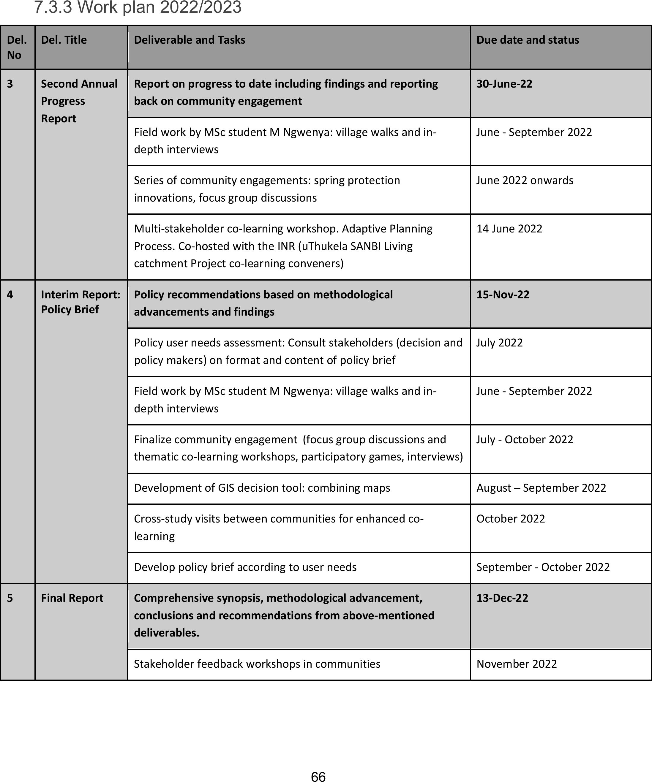
66
7.3.3 Work plan 2022/2023
Del.
No
Del. Title
Deliverable and Tasks
Due date and status
3
Second Annual
Progress
Report
Report on progress to date including findings and reporting
back on community engagement
30-June-22
Field work by MSc student M Ngwenya: village walks and in-
depth interviews
June - September 2022
Series of community engagements: spring protection
innovations, focus group discussions
June 2022 onwards
Multi-stakeholder co-learning workshop. Adaptive Planning
Process. Co-hosted with the INR (uThukela SANBI Living
catchment Project co-learning conveners)
14 June 2022
4
Interim Report:
Policy Brief
Policy recommendations based on methodological
advancements and findings
15-Nov-22
Policy user needs assessment: Consult stakeholders (decision and
policy makers) on format and content of policy brief
July 2022
Field work by MSc student M Ngwenya: village walks and in-
depth interviews
June - September 2022
Finalize community engagement(focus group discussions and
thematic co-learning workshops, participatory games, interviews)
July - October 2022
Development of GIS decision tool: combining maps
August – September 2022
Cross-study visits between communities for enhanced co-
learning
October 2022
Develop policy brief according to user needs
September - October 2022
5
Final Report
Comprehensive synopsis, methodological advancement,
conclusions and recommendations from above-mentioned
deliverables.
13-Dec-22
Stakeholder feedback workshops in communities
November 2022

67
8. References
Abule, E, Snyman, HA, Smit, GN et al. 2007. Rangeland evaluation in the middle Awash valley of Ethiopia:
I. Herbaceous vegetation cover. Journal of Arid Environments, doi: 10.1016 2006.12.008.
Allen, VG, Batello, C, Berretta, EJ, Hodgson, J, Kothmann, LiX, McIvor, J, Milne, J, Morris, C, Peeters, A,
Sanderson, M et al. 2011. An international terminology for grazing lands and grazing animals. Grass and
Forage Science 66: 2 – 28.
Benjaminsen, T, Rohde,R, Sjaastad E et al. 2006. Land reform, range ecology, and carrying capacities in
Namaqualand, South Africa. Ann Assoc Am Geo 96:524–540
Biggs, R, Schlüter, M, & Schoon, M Ed. 2015. Principles for building resilience. Sustaining ecosystem
services in social-ecological systems. Cambridge University Press, Cambridge, UK.
Binder, C, Hinkel J, Bots, P et al. 2013. Comparison of frameworks for analyzing social-ecological systems.
Ecol Soc 18:26.
Bosch, OJH, Theunissen, JD et al. 1992. Differences in the responses of species on the degradation of
gradient in the semi-arid grasslands of southern Africa and the role of ecotypic variation. In: Chapman, G
(Editor). Desertified Grasslands: Their Biology and Management. The Linnean Society of London, London,
pp. 95-108.
Charnley, S, Carothers, C, Satterfield, T. 2017 Evaluating the best available social science for natural
resource management decision-making. Environ Sci Pol 73:80-88.
Cockburn, J, Schoon, M, Cundill, G et al. 2020. Understanding the context of multifaceted collaborations
for social-ecological sustainability: a methodology for cross-case analysis. Ecol Soc 25(3):7.
Cousins, B. 2009. Potentials and pitfalls of ‘communal’ land tenure reform: experience in Africa and
implications for South Africa. Paper for World Bank Conference on Land Governance in Support of the
MDGs Responding to New Challenges, Washington
Delgado-Serrano, M, Oteros-Rozas, E, Ruiz-Mallén, I et al. 2018. Influence of community-based natural
resource management strategies in the resilience of social-ecological systems. Reg Environ Chang
18:581-592.
Duraiappah, A, Asah, T, Brondizio E et al. 2014. Managing the mismatches to provide ecosystem services
for human well-being: a conceptual framework for understanding the New Commons. Curr Opin Environ
Sust 7:94–100.
Feeny, D, Berkes, F, McCay, B 1990 The tragedy of the commons: twenty-two years later. Hum Ecol 18:1-
19

68
Fischer, A & Young, J 2007 understanding mental constructs of biodiversity: Implications for biodiversity
management and conservation. Biol Conserv 136:271-282
Frost, P, Medina, E, Menaut, JC, Solbrig, O, Swift, M, Walker, B et al. 1986. Responses of savannas to
stress and disturbance, Biology International, Special Issue 10.
Gamoun, M. 2014. Grazing intensity effects on the vegetationin desert rangelands of Southern Tunisia.
J. Arid. Land. 6, 324-333.
Guerrero, A. M., N. J. Bennett, K. A. Wilson, N. Carter, D. Gill, M. Mills, C. D. Ives, M. J. Selinske, C.
Larrosa, S. Bekessy, F. A. Januchowski-Hartley, H. Travers, C. A. Wyborn, and A. Nuno. 2018. Achieving
the promise of integration in social-ecological research: a review and prospectus. Ecology and Society
23(3):38.https://doi.org/10.5751/ES-10232-230338
Gxasheka, M, Solomon, TB, Mlisa, NL, Lesoli, M et al. 2017. Farmers’ perceptions of vegetation
change,rangeland condition and degradation in three communal grasslands of South Africa. J. Trop.
Ecol.58,217-228.
Henriksson Malinga, R, Lindborg, R, Andersson, E et al. 2018. On the other side of the ditch: Exploring
contrasting ecosystem service co-production between smallholder and commercial agriculture. Ecol Soc
2
Hardy, M, Tainton, NM. 1993. Towards a technique fordetermining basal cover in tufted grasslands.
African Journal of Range and Forage Science. 10:2:77-81.
Hardy, M, Barnes, RD, Kirkman, K. 1999. Sour grassveld. In Tainton N (ed) Veld management in South
Africa, University of Natal Press, Pietermaritzburg, South Africa.
Harrison, YA, Shackleton, CM. 1999. Resilience of South African communal grazing lands after the remov
Hoffman, T, Ashwell, A. 2001. Nature divided. Land degradation in South Africa. University of Cape
Town, South Africa.al of high grazing pressure. Land Degradation & Development 10: 225-239.3(4):9.
Kenter, J, Jobstvogt, N, Watson, V et al. 2016. The impact of information, value-deliberation and group-
based decision-making on values for ecosystem services: Integrating deliberative monetary valuation
and storytelling. Ecosyst Serv 21:270-290.
Kgosikoma, OE, Mojeremane, W, Harvie, BA et al. 2012. Grazing management systems and their effects
on savanna ecosystem dynamics: A review. Journal of Ecology and the Natural Environment 5 (6): 88 - 9.
Kunst, C, Monti, E, Perez, H, Godoy, J et al. 2006. Assessment of the rangelands of Southwestern
Santiago del Estero, Argenina, for grazing management and research. Journal of Environmental
Management. 80: 248 – 265.

69
Lesoli, MS. 2008. Vegetation and soil status and human perceptions on the condition of communal
rangelands of the Eastern Cape, South Africa. MSc. Dissertation, University of Fort Hare, Alice, South
Africa.
Lindborg, R, Gordon, LJ, Malinga, R et al. 2017. How spatial scale shapes the generationand
management of multiple ecosystem services. Ecosphere 8(4):e01741.
Liu, H, Han, X, Li, L, Huang, J, Li, X et al. 2009. Grazing density effects on cover, species composition, and
nitrogen fixation of biological soil crust in an Inner Mongalia steppe. Range. Ecol. Managem. 62, 321-
327.
Malan, PW, Van Niekerk. 2005. The extent of grass species composition in Braklaagte, Zeerust District,
North-West Province, South Africa. African Journal of Range and forage Science 22(3): 177- 184.
Milchunas, DG, Sala, OE, Lauenroth, WK et al. 1988. A generalized model of the effects of grazing by
large herbivores on grassland community structure, American Naturalist 132, 87-106.
Moyo, B, Dube, S, Lesoli, M, Masika, PJ et al. 2008. Communal area grazing strategies: institutions
andtraditional practices, African Journal of Range & Forage Science, 25:2, 47-54.
Mucina, L, Rutherford, MC. 2006. The vegetation of South Africa, Lesotho and Swaziland. SANBI,
Pretoria.
Muhar, A, Raymond, C, van den Born, R et al. 2018. A model integrating social-cultural concepts of
nature into frameworks of interactions between social and natural systems. J Environ Plan Manag
61:756-777.
Ndandani, A. 2016. Range condition assessment to document the extent of degradation on selected
semi-arid rangelands of the Eastern Cape, South Africa. MSc Thesis University of Fort Hare, Alice, South
Africa.
Ntshidi, Z., Gush, M., Dzikiti, S., Le Maitre, D., 2018. Characterising the water use and hydraulic
properties of riparian tree invasions: A case study of Populus canescens in South Africa. Water SA 44..
doi:10.4314/wsa.v44i2.18
O'Connor, TG, Kuyler, P, Kirkman, KP, Corcoran, B et al. 2010. Which grazing management practices are
most appropriate for maintaining biodiversity in South African grassland?, African Journal of Range &
Forage Science 27, 67-76. http://dx.doi.org/10.2989/10220119.2010.502646
Oström, E. 1990. Governing the commons: the evolution of institutions for collective action. Cambridge
University Press, Cambridge.
Pacheco-Romero, M, Alcaraz-Segura, D, Vallejos, M., and Cabello, J. 2020. An expert-based reference list
of variables for characterizing and monitoring social-ecological systems. Ecol Soc 25(3):1.

70
Pardoe, J 2016. Multiple and more frequent natural hazards: The vulnerability implications for rural
West African communities Doctoral dissertation University of Bonn, Germany
Peterson, G, Harmackova, Z, Meacham, M. et al. 2018. Welcoming different perspectives in IPBES:
“Nature’s contributions to people” and “Ecosystem services”. Ecol Soc 23:39
Rasmusen, LN, Meinzen-Dick, R. 1995. Local organisations for natural resource management: lessons
from theoretical and empirical literature. Environment and Production Technology Division Discussion
Paper 11. International Food Policy Research Institute, Washington, DC, USA.
Reed, M, Graves, A, Dandy, N et al. 2009. Who’s in and why? A typology of stakeholder analysis methods
for natural resource management. J Environ Manage 90:1933-1949.
Reid, R, Galvin, KA, Kruska R et al. 2008. Global significance of extensive grazing lands and pastoral
societies: an introduction. In: Galvin KA, Reid R, Behnke RH, Hobbs NT (eds), Fragmentation in arid and
semi-arid landscapes: consequences for human and natural systems. Dordrecht: Springer. pp 1–24.
Rutherford, M, Powrie, L. 2013. Impacts of heavy grazing on plant species richness: A comparison across
rangeland biomass of South Africa. S. Afr. J. Botany. 87,146-156.
Sinare, H, Gordon, L, & Enfors Kautsky, E 2016. Assessment of ecosystem services and benefits in village
landscapes – A case study from Burkina Faso. Ecosyst Serv 21(Part A):141-152.
Savory Institute. 2015b. E-book eight: The fundamentals of Holistic Planned Grazing. Colorado: Savory
Institute [Online]. Available: https://savory-institute.myshopify.com/collections/ebook-bundles [2022,
May 25].
Strugnell, RG, Pigott, CD.1978. Biomass, Shoot production and grazing of two grasslands in Rwenzori
National Park, Uganda, Journal of Ecology, 66, 73-96.
Tengö, M, Brondizio, E, Elmqvist, T, et al. 2014. Connecting Diverse Knowledge Systems for Enhanced
Ecosystem Governance: The Multiple Evidence Base Approach. Ambio 43:579–591.
Todd, SW, Hoffman, MT. 1999. A fence-line contrast reveals effects of heavy grazing on plant diversity
and community composition in Namaqualand, South Africa. Plant Ecology 142: 169- 178.
Trollope, WSW. 1989. Veld burning as a management practice in livestock production. In: J. E.
Danckwerts and Teague, W. R. (eds). Veld management in the Eastern Cape. Department of Agriculture
and WaterSupply, Eastern Cape Region, South Africa. pp. 4930: 67-73.
Trollope, WSW, Trollope, LA, Bosch, OHJ et al. 1990. Veld and pasture management terminology in
Southern Africa. Journal of the Grassland Society of Southern Africa 71: 52 – 61.

71
Trollope, WSW, Trollope, L. A. 1996. Fire in African savanna and other grazing ecosystems. Paper
presented at the seminar on “Forest Fire and Global Change” held in Shushenkoye in the Russian
Federation from the 4th-10th August, 1996. pp. 1-27.
UNEP. 2015. The Economicsof Land Degradation in Africa, ELD Initiative, Bonn, Germany Available from
www.eld-initiative.org
Van der Westhuizen, H, Snyman, H, Fouché H et al. 2005. A degradation gradient for the assessment of
rangelandcondition of a semi-arid sourveld in southern Africa. African Journal of Range and Forage
Science 22(1): 47-58.
Vetter, S. 2003. What are the costs of land degradation to communal livestock farmers in South Africa?
The case of the Herschel District, Eastern Cape: PhD thesis, University of Cape Town. South Africa.
Vetter, S, Goqwana, WM, Bond, WJ, Trollope, WSW et al. 2006. Effects of land tenure, geology and
topography on vegetation and soils of two grassland types in South Africa. African Journal of Rangeand
Forage Science. 23: 13 – 27.
Voisin, A. 1988. Grass productivity. Washington D.C.: Island Press.
Walker, BH, Langridge, JL, McFarlane, F et al. 1997. Resilience of an Australian savanna grassland to
selective and non-selective perturbations, Australian Journal of Ecology, 22, 125-135.
Ward, D, Ngairorue, BT, Kathena, J, Samuels, R, Ofran, Y et al. 1998. Land degradation is not a necessary
outcome of communal pastoralism in arid Namibia. Journal of Arid Environments 40, 357–371.
Zambatis, N, Zacharias, PJK, Morris, C, Derry, JF. 2006. Re-evaluation of the disc pasture meter
calibration for the Kruger National Park, South Africa. African Journal of Range and Forage Science.

72
9. Appendices
Appendix 1.
Participatory Mapping Workshop Schedule
Village: Ezimbomvu/CostoneDate:
Group: Men/women/decision makers
Venue:
Equipment:Maps, flipchart, markers, camera
Introduction – (3 mins)
Goals and objective: The objective of this mapping workshop is to identify and map different social-
ecological patches found across the village landscape
Why:In order to assist the community to manage their natural resources sustainably and equitably
How:By mapping all key natural resources that are perceived to be important by local community
members.
With who:Different community members and groups– (Community leaders/decision-makers, local
facilitators/community liaison ppl, Water committee, Grazing committee, MDF group members, Non-
MDF group members
Output:Village map of key social-ecological patches
Step 1: Introducing the activity to participants – (3 - 5mins)
· A clear explanation to participants on what the map will be used for, and what it will not be used
for.
· The map will not be used for any official uses such as land demarcation, and will not be shared
with those outside the research team such as local government or other implementers
· Explain clearly what mapping activity will be done during the session with each group (e.g. grazing
lands with grazing committee group, water sources with water committer group or cropping fields lands
with crop farmers)
· Explain that any use of the map (e.g., in future scientific publications) will maintain the anonymity
of the village and need prior approval from participants
· Allow some time for questions and for addressing concerns.

73
· Each group will be assigned with different colour makers for each category so that it is easy for the
researcher to analyse the results and when presenting the maps to participants.
· Ask participants to make a mark or draw a polygon to locate a feature.
Step 2: Familiarizing participants with the map – (5-10 mins)
· Participants will be given a chance to familiarize themselves with the map before the mapping
activity; to make sure everyone understands the mapping exercise;
· Participants will be asked to first draw the village boundaries and identify key locations in the
Village that people are familiar with (e.g. roads, houses, spaza shops, fields, mountains, etc.)
Step 3: Identify and map main land uses – (15 -20 mins)
Participants will be asked to mark and draw the following main land uses:
· Where your residents located (their houses)?
· Where are grazing lands located?
· And what types of livestock are grazing there the most?
· Where are your farmlands (homesteads, crops fields)?
· What types of crops are grown most?
· Where are recreational and sacred areas (sacred areas or gravesites)?
· Do men and women have their own/separate land?
Step 4: Identify and map ecosystem services – (15 -20min)
Ask participants to list all the key ES found in their village and where these collected:
· Water
· Livestock grazing
· Hunting
· Firewood
· Medicinal plants
· Building materials (poles, thatch grass, broom grass)
· Recreational and cultural meeting places (playground –soccer, river swimming)
· And more

74
Step 5: Identify areas of inadequately supply – (2 mins)
· Ask participants to mark and draw where ecosystem services are no longer or provide insufficient
supply (e.g. degraded areas which includes overgrazed areas, gullies, dongas, wetlands, bush
encroachment).
Step 6: Identify power dynamics and unequal access to ES –(2 mins)
Ask participants to mark and draw areas with restricted/open access
If restricted why?
Step 7: Priorities/needs of ES – (2 mins)
· Ask participants to mark and draw areas that need to be prioritized in terms of social-ecological
patches, ecosystem services and livelihoods.
Step 8: Suggestions for managing land and water resources sustainably and equitable – (3mins)
· how ES can be protected, conserved and managed equitably and sustainably for the benefits of
women and society.
Step 9: Asking participants to update the map – (1 min)
· Ask participants to change village boundaries or add anything that may be wrong ormissing.

75
Appendix 2.
Guide for focus group discussion on decision-making.
Focus group questions DECISION-MAKING
1
What do you understand by natural resource management and land use management (See what
people say and then add some definitions to assist)?
2
What are the land use practices in your area at present. What were they in the past? What might
they look like in the future? (consider cropping, livestock, water, harvesting of wild plants, cutting
of trees for firewood, sand mining, demarcation of land, PTO’s etc)
3
Who makes decisions in each case? And how are these decisions made? (For each of the land use
management practices described in question 2)
4
Who gets access and who doesn’t. Please explain and outline? (e.g., men-women, poor-rich,
friends-others, long term residents-new residents etc)
5
What is the relationship of community members with TAs and Councillors? (Is it the same for all
people, how do you gain access, can anyone interact, what are the rules…)
6
What role do the councillors play? (Do they have any role in natural resources and land use
management – e.g., water,
7
How has access changed in the last 10 years and why?
8
How has CC affected the natural resources? And community members access to these?

76
Appendix 3.
Accepted abstract for oral presentation at Southern African Mountain Conference in March 2022.
Community based climate change adapTation in the Central-Drakensberg improves resilience of
smallholder farmers
Kruger, E.1, Henriksson, R.2and Toucher, M.3
1Mahlathini Development Foundation, Pietermaritzburg, KwaZulu Natal, South Africa. 2Centre for Water
Resources Research, University of KwaZulu Natal, Pietermaritzburg, KZN, South Africa. 3Grasslands-
Wetlands-Forests Node, South AfricanEnvironmental Observation Network, Pietermaritzburg, KZN,
South Africa
Keywords: CbCCA, Social-ecological systems, climate resilient agriculture, resilience impact assessment.
Introduction
Weather variability and climate change have significant impacts onthe livelihoods of the rural poor in
communal tenure villages in the Central Drakensberg region. While annual rainfall totals have been lower
in the catchment the recent decade compared to the historical mean (1951 – 1980), the mean annual
temperature hasbeen above the historical mean (1951 – 1980) bymore than 1.5 ⁰C. Increased co-learning
with local communities is necessary to be better equipped to adapt to the changing social-ecological
circumstances and to tackle climate challenges.
Aim
Village based climate resilient agriculture (CRA) learning groups were aimed to provide for a coherent
social-ecological setting for exploration and implementation of adaptive strategies and practices, as well
as improved understanding of the natural resource base and its use and managementwithin the
communities.
Methods
In this transdisciplinary mixed-method approach, 250 smallholder farmers across 18 villages have
implemented a range of CRA practices including regenerative agriculture, livestock integration and
intensive homestead food production alongside rainwater harvesting, soil and water conservation and
management of local water source areas. A suite of climate resilience impact indicators and indices has
been developed to track social, economic, environmental and productivity aspects of resilience and
provide snapshots for improved adaptation and resilience. In two villages, a social-ecological participatory
mapping exercise is being developed to assess the nature resource base, local land uses and associated
ecosystem services andlivelihood benefits.
Results
Smallholder farmers have made significant strides in improving the sustainability of their farming systems
and developing local value chains and food systems and have improved their livelihoods through

77
increased productivity and local marketing initiatives. Positive trends in soil health, water availability and
infiltration and water productivity have been measured, and increased understanding of the climate
impacts and management implications on the community landscape and its resources is being developed.
Discussion
This approach has highlighted the importance to improve social agency for natural and water resources
management in community based climate adaptation. Ongoing mentoring and implementation of CRA
strategies, alongside with co-learning within a multi- and transdisciplinary team provides sustainability in
community level management of current and future resources.
Conclusion
Further deepening of the co-learning process and long-term establishment of innovations is required to
maintain the positive impacts of this approach, and methods to upscale the project are necessary.