
The Water Wheel November/December 20191

3
CONTENTS
THE WATER WHEEL is a two-monthly
magazine on water and water research
published by the South African Water
Research Commission (WRC), a statutory
organisation established in 1971 by
Act of Parliament. Subscription is
free. Material in this publication does
not necessarily reflect the considered
opinions of the members of the WRC,
and may be copied with acknow-
ledgement of source.
Editorial Committee:
Dr Sylvester Mpandeli (Chair), Ms Khosi
Jonas, Ms Manjusha Sunil, Mr Bonani
Madikizela, Dr Mamohloding Tlhagale
and Sudhir Pillay.
Editorial offices:
Water Research Commission, Private
Bag X03, Gezina, 0031, Republic of
South Africa.
Tel (012) 761 9300. Fax (012) 331-2565.
WRC Internet address:
http://www.wrc.org.za
Follow us on Twitter:
@WaterWheelmag
Editor: Lani van Vuuren,
E-mail: laniv@wrc.org.za;
Editorial Secretary: Dikeledi Molutsi,
E-mail: dikeledidk@wrc.org.za;
Layout: Anja van der Merwe,
E-mail: anjavdm@wrc.org.za
South Africa’s aquatic
nurseries are under threat,
evidence shows. See the
article on page 12.
UPFRONT
ESTUARIES
Fisheries in South African estuaries
WATER AND THE ENVIRONMENT
Cape’s endemic fish swimming for survival
WEATHER FORECASTING
Gough: The remote island that all South Africans depend on
AGRICULTURE AND WATER
Agriculture’s water challenges – Digging for solutions
RESILIENT CITIES
Water funds: Innovative tools to promote water security
SMALLHOLDER IRRIGATION
Smallholder irrigation schemes under the spotlight
CLIMATE CHANGE
Creating climate change resilient communities Part 2: Impact of
climate resilience practices on rural livelihoods
AGRICULTURE AND POLLUTION
Toxic farm chemicals: Emerging threat to South Africa’s surface
waters
WATER KIDZ
Water wheels - Harnessing nature’s power
AT A GLANCE
Buchuberg – The ‘forgotten’ dam of the Orange River
04
12
16
21
26
34
The Water Wheel November/December 2019
30
37
44
40
46
The Water Wheel November/December 2019
4
FLUID THOUGHTS
Future-proofing food security in a hotter,
drier world
We are in the middle of a South African heatwave.
The Northern Hemisphere has just completed a very
uncomfortable summer, with July 2019 being the hottest July in
recorded history. The start of the Southern Hemisphere spring
appears to be completing the 2019 weather cycle in competition
with the North – promising a hot, dry summer with intervals of
short, intense rainfall spells. In other words, more threats to our
food security.
In the midst of this, World Food Day 2019, celebrated on
15 October, continued to leave us uncomfortable. While
considerable progress has been made in various parts of the
world, we still have 821 million people that suffer from chronic
undernourishment. That’s more than 10% of the world’s
population. The number for South Africa, according to Statistics
South Africa, is 6.8 million people that are chronically hungry, that
is going to bed on an empty stomach daily. In this mix are the
500 000 households with children that are subject to these same
hunger pangs. We add to this the growing global epidemic of
obesity and malnutrition to complete the ticking time-bomb of
the global nutrition challenge of the 21st century.
We also know that undernutrition is a central pillar of the poverty
trap. Poverty restricts access to food. This leads to restricted
development both physically and cognitively. This is super-critical
in the first 90 days of a child’s life and in general if this persists for
the first 4 years – the damage is largely irreversible. This, in turn,
limits economic activity and productivity which perpetuates the
poverty, and the cycle continues inter-generationally. The outlook
is dimmed by the prospect of an even more difficult environment
on the back of climate change and increased frequency of
extreme weather events like droughts and floods. How do we
organise for future food security to enable the next generation
to successfully escape the poverty trap in South Africa and the
world?
The key engines to future proof food security include the
following. First is the toolbox of the 4th Industrial Revolution (4IR).
Higher levels of computation and artificial intelligence enable the
old dream of precision agriculture. Optimally using key resources
like water, energy, fertilizers and other growth enablers on the
back of better more accessible real-time information to drive
efficient agriculture and higher productivity. An important anxiety
associated with these interventions is automation, and the
potential negative impact that it will have on jobs and livelihoods.
4IR can, in fact, stimulate and achieve exactly the opposite.
Currently, 70% of the world’s food is produced by 500 million
small-scale farmers. Mobile technology tools will enable these
500 million farmers to have a reasonable component of real-time
information to perform state-of-the-art precision agriculture on
the smallest of plots – increasing productivity and drastically
reducing costs.
Secondly, with the advent of new innovations, such as the
concept of social franchising, can double the number of small-
scale farmers and therefore agricultural productivity in the next
ten years globally. Social franchising has been successfully piloted
by the Water Research Commission (WRC) and is a new model
for enterprise development where someone can become with a
zero financial investment with access to a support structure for an
initial period.
The WRC pilot has created 20 companies, each now employing
at least three people and still in business three years on. This may
be a viable mechanism for emerging farmers in South Africa and
means to achieve a global target of 1 billion small-scale farmers
and many more entrepreneurs in the food value chain.
However, these interventions may prove ineffective against the
vagaries of heatwaves and extreme weather events catalysed
by climate change. There is also the matter of the obesity and
malnutrition epidemic. Key to food security resilience in diversity
of staples. If these new staple crops have the added benefits of
higher nutrition levels and greater tolerance to drier conditions,
then we truly have a winning solution.
The third intervention is thus underutilised and orphan crops.
They are sometimes also referred to as traditional crops, because
our wise ancestors had an important handle on food security,
albeit on a smaller scale, and are in most cases indigenous.
Research has shown that in general they use much less water
than their exotic mainstream monoculture cousins – making
them more resilient to drought conditions. They are also
more nutritious with higher levels of iron and trace elements,
becoming an important bastion against malnutrition. Examples
include well known sweet potato, Bambara groundnut, cowpeas,
Upfront
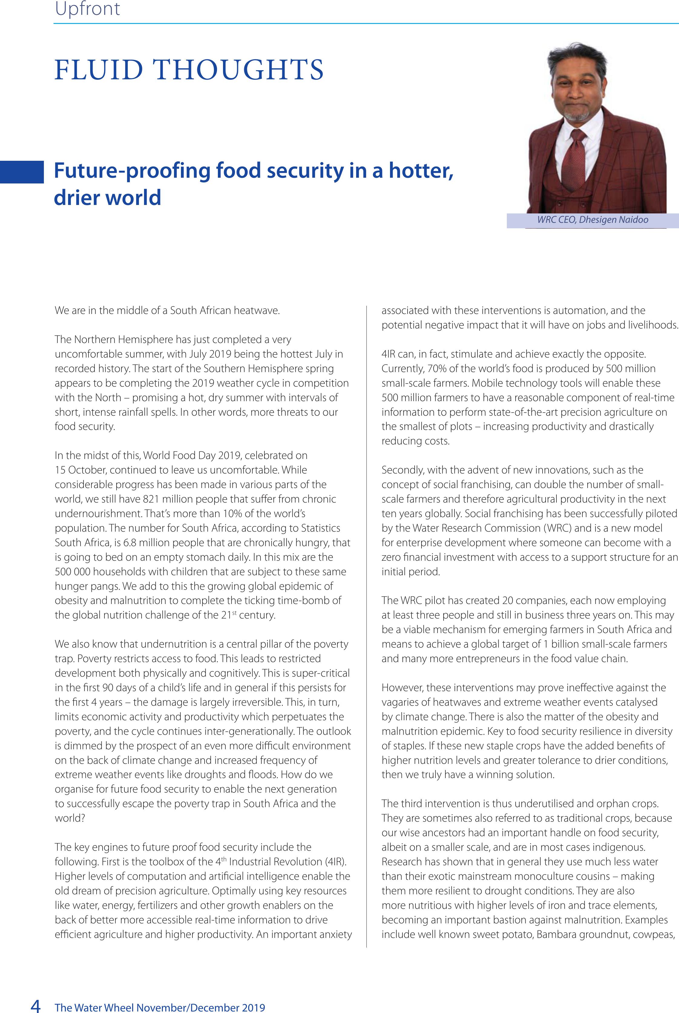
WRC CEO, Dhesigen Naidoo
BACK TOP TOP

The Water Wheel November/December 20195
Upfront
spider plant and indigenous spinach – amaranthus or morogo. The super-resilient include sorghum, which is both drought tolerant as well
as tolerant to waterlogging.
The Green Revolution of the 1950s and 1960s massified agriculture in a mono-culture paradigm to stave off mass hunger and was very
successful. The 21st century agricultural revolution lies in a new diversification in a resource efficient and resilient agricultural model
enabled by the innovations of the 4th industrial revolution.
Water and development
1-5 December
The International Water Association (IWA)
is hosting its Water and Development
Congress & Exhibition in Colombo,
Sri Lanka.
Visit: www.waterdevelopmentcongress.org
Small water systems
1-5 December
The 16th International Specialised
Conference on Small Water and
Wastewater Systems will be held in
Murdoch, Australia.
Visit: www.swws2019.com
Water governance
11-13 February 2020
The Water Institute of Southern Africa
(WISA) is offering a three-day training
course in Stellenbosch on water
governance. The course has been
designed to facilitate understanding
of the principles of water governance
from a human rights perspective, and
covers international water governance
approaches, sustainable water resource
management initiatives, and the
implementation of measures in South
Africa through the relevant legislation.
Visit: www.wisa.rog.za
Sanitation
21-24 July 2020
The First IWA Non-Sewered Sanitation
specialist group conference is being
hosted at the Future Africa Campus in
Pretoria in partnership with the Water
Research Commission and the University
of Pretoria. The aim of the conference
is to provide stimulus for research and
innovation for non-sewered sanitation
WATER DIARY
and off-grid sanitation solutions, including
faecal sludge management, build the
technical and scientific base for sanitation
and to contribute to scientific knowledge
and good practice learnings. Enquiries: Dr
Sudhir Pillay, Email: sudhirp@wrc.org.za,
Visit: www.shorturl.at/DIJQ0
World Water
18-23 October 2020
The IWA World Water Congress will take
place in Copenhagen, Denmark with the
theme ‘Water for smart liveable cities’.
Visit: https://worldwatercongress.org/
Municipal water
28-30 October 2020
The Institute of Municipal Engineering of
Southern Africa will be holding its annual
conference in Cape Town.
Visit: https://www.imesa.org.za/
The number of undernourished people in the world has been on the rise since 2015, and is back to levels seen in 2010/11.
Source: FAO
BACK TOP TOP

The Water Wheel November/December 2019
6
NEWS
Upfront
High spring temperatures negatively impacting South Africa’s water
reported in October. According to
Dr Chris Moseki, Specialist Scientist in
the DWS, scientific projections are that
hot temperatures will persist until the
end of summer next year. Between
October and December the country will
experience below-average rains that will
be accompanied by hot temperatures
that will continue to raise evaporation
levels in dams.
However, the South African Weather
Service (SAWS) predicts that between
mid-December and February next year
the major parts of the country may
receive heavy rains, which may lead to
flash floods.
“Key to the water situation is the
responsibility of South Africans to use
water wisely and sparingly. We must move
away from the dogma that water is the
government’s responsibility alone,” noted
Dr Moseki.
Against this background, the DWS has
renewed the call to all South Africans to
intensify their water conservation efforts.
Source: DWS
Efforts to clamp down on pollution in Knysna
nutrients in the wastewater treatment
works effluent – including ammonia,
pH level, nitrates, suspended solids and
chlorine – are being monitored closely.
Park Manager for Knysna, Megan Taplin,
said: “High readings of ammonia are
a concern for South African National
Parks (SANParks) for the survival of both
plant and animal life in the estuary.” She
adds that the SANParks team is working
with their partners to do more than just
sample for E.coli in the Knysna estuary, but
monitoring all potential polluters.
“Our partnership with the municipality
allows monitoring of solid waste and
systems leading to the wastewater
treatment works. Oil and grease influx
to the works and sewer system is also
being monitoring by the municipality,” she
added.
There is evidence of high loads of oil
entering the system and ending up at the
wastewater treatment works. Authorities
are ramping up efforts to find the
source(s) of the oil along the networks.
“If we can determine the trends of when
the oil and grease enter the wastewater
treatment works..it might make it easier
to track the polluter,” noted Knysna
Municipality Technical Director, Pravir
Hariparsad.
A positive move is the number of
interventions planned for the estuary,
including the planned appointment of a
freshwater specialist by the municipality.
The specialist will assess the Bongani River
system from source to sea.
Source: SANParks
Authorities in Knysna have begun a drive
to tackle pollution threatening the Knysna
estuary.
Positive, proactive engagements are
underway by various stakeholders
forming part of the Knysna Authorities
Pollution Committee. Among others,
The recent high temperatures being
experienced over large parts of South
Africa are having a negative impact on
South Africa’s dam levels, according to
the Department of Water and Sanitation
(DWS).
A weekly report by the DWS shows that
as a result of sweltering temperatures,
dam levels are dropping at an average 1%
week-on-week. Comparatively, dam levels
have dropped 10%, from 74% to 64%
compared to the same period last year.
Even more alarming is the water situation
in Limpopo and the Eastern Cape where
dam levels had dropped to almost half of
where they were in 2018, the department
BACK TOP TOP
The Water Wheel November/December 20197
Upfront
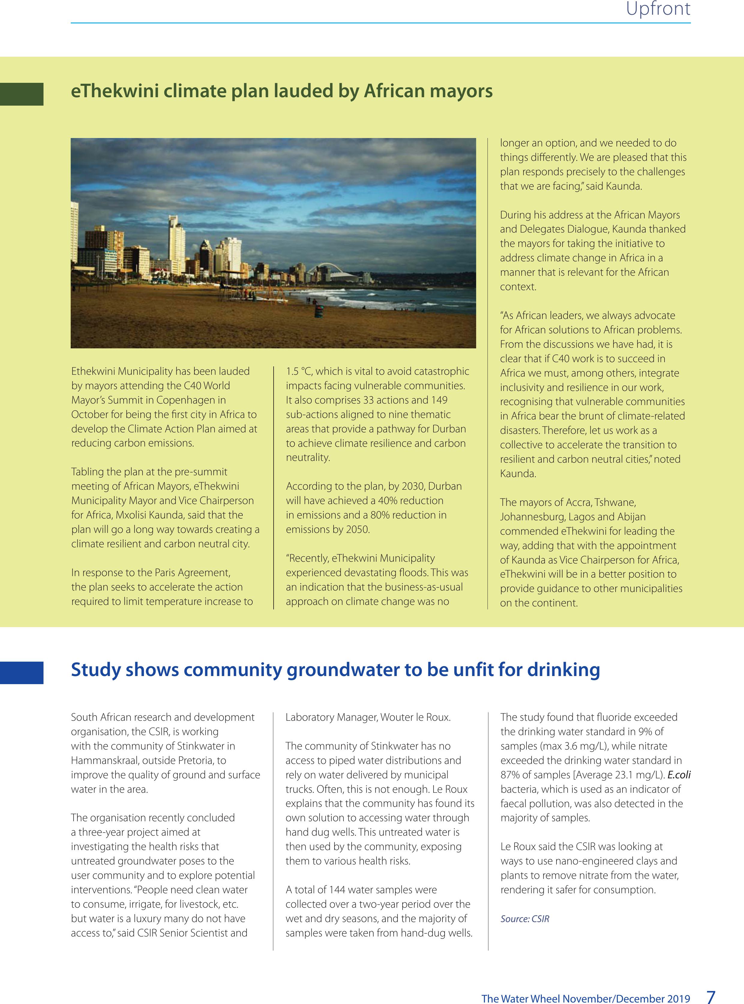
eThekwini climate plan lauded by African mayors
Ethekwini Municipality has been lauded
by mayors attending the C40 World
Mayor’s Summit in Copenhagen in
October for being the first city in Africa to
develop the Climate Action Plan aimed at
reducing carbon emissions.
Tabling the plan at the pre-summit
meeting of African Mayors, eThekwini
Municipality Mayor and Vice Chairperson
for Africa, Mxolisi Kaunda, said that the
plan will go a long way towards creating a
climate resilient and carbon neutral city.
In response to the Paris Agreement,
the plan seeks to accelerate the action
required to limit temperature increase to
1.5 °C, which is vital to avoid catastrophic
impacts facing vulnerable communities.
It also comprises 33 actions and 149
sub-actions aligned to nine thematic
areas that provide a pathway for Durban
to achieve climate resilience and carbon
neutrality.
According to the plan, by 2030, Durban
will have achieved a 40% reduction
in emissions and a 80% reduction in
emissions by 2050.
“Recently, eThekwini Municipality
experienced devastating floods. This was
an indication that the business-as-usual
approach on climate change was no
longer an option, and we needed to do
things differently. We are pleased that this
plan responds precisely to the challenges
that we are facing,” said Kaunda.
During his address at the African Mayors
and Delegates Dialogue, Kaunda thanked
the mayors for taking the initiative to
address climate change in Africa in a
manner that is relevant for the African
context.
“As African leaders, we always advocate
for African solutions to African problems.
From the discussions we have had, it is
clear that if C40 work is to succeed in
Africa we must, among others, integrate
inclusivity and resilience in our work,
recognising that vulnerable communities
in Africa bear the brunt of climate-related
disasters. Therefore, let us work as a
collective to accelerate the transition to
resilient and carbon neutral cities,” noted
Kaunda.
The mayors of Accra, Tshwane,
Johannesburg, Lagos and Abijan
commended eThekwini for leading the
way, adding that with the appointment
of Kaunda as Vice Chairperson for Africa,
eThekwini will be in a better position to
provide guidance to other municipalities
on the continent.
Study shows community groundwater to be unfit for drinking
South African research and development
organisation, the CSIR, is working
with the community of Stinkwater in
Hammanskraal, outside Pretoria, to
improve the quality of ground and surface
water in the area.
The organisation recently concluded
a three-year project aimed at
investigating the health risks that
untreated groundwater poses to the
user community and to explore potential
interventions. “People need clean water
to consume, irrigate, for livestock, etc.
but water is a luxury many do not have
access to,” said CSIR Senior Scientist and
Laboratory Manager, Wouter le Roux.
The community of Stinkwater has no
access to piped water distributions and
rely on water delivered by municipal
trucks. Often, this is not enough. Le Roux
explains that the community has found its
own solution to accessing water through
hand dug wells. This untreated water is
then used by the community, exposing
them to various health risks.
A total of 144 water samples were
collected over a two-year period over the
wet and dry seasons, and the majority of
samples were taken from hand-dug wells.
The study found that fluoride exceeded
the drinking water standard in 9% of
samples (max 3.6 mg/L), while nitrate
exceeded the drinking water standard in
87% of samples [Average 23.1 mg/L). E.coli
bacteria, which is used as an indicator of
faecal pollution, was also detected in the
majority of samples.
Le Roux said the CSIR was looking at
ways to use nano-engineered clays and
plants to remove nitrate from the water,
rendering it safer for consumption.
Source: CSIR
BACK TOP TOP
The Water Wheel November/December 2019
8

The Water Wheel November/December 20199
Upfront
Determining the water footprints of selected eld and forage
crops, and derived products in South Africa
This research has addressed important issues in agricultural
sustainability and human survival as a whole in South Africa. The
research established country-specific standardised procedures
for calculating blue and green water footprints for irrigated field
and forage crops, and this can contribute towards the setting of
accurate benchmarks for freshwater use along the lifecycle of
crops. The research has linked the water footprint applications
to economic and social analytical tools. The inclusion of the
social and economic impacts of proposed changes in water
use behaviour provides details insights and understanding
of water management. The analysis of consumer awareness,
preference and willingness to pay for water footprint information
on product labels gives insight into the scope for incentivising
water users through price premiums to use freshwater efficiently.
Report no. 2397/1/19
WET-RehabEvaluate Version 2: An integrated monitoring and
evaluation framework to assess wetland rehabilitation in South
Africa
WET-RehabEvaluate was developed as a framework to guide
the application of monitoring and evaluation during wetland
rehabilitation projects, but further experience and recent
research have identified several potential improvements required
for evaluating wetland rehabilitation efforts. In an attempt to
capture these improvements, the Water Research Commission
(WRC) research project sought to compile a framework that is a
user-friendly guide for implementing monitoring and evaluation
for wetland rehabilitation in South Africa. WET-RehabEvaluate
was used as the starting point for the improved framework,
although significant changes were incorporated to address
identified shortfalls. Once a draft framework was compiled,
which reflected recent experience and research, it was assessed
through an iterative process that applied the framework (or
parts thereof) to eleven cases during a research process. Lessons
learnt after each application were fed back into the framework
development process.
Report no. 2344/1/19
Urban groundwater development and management
Groundwater use by urban areas urgently needs to shift from
lack of active management of groundwater and indirect use (of
groundwater’s assimilative capacity) with negative implications,
to active management leading to the potential for bulk water
supply from urban groundwater resources. In cases where urban
groundwater will not be used for bulk supply for whatever
reason, active management of the urban groundwater is still
required to protect the resource for other uses (ecological
services, garden irrigation, food gardens). Contributing to
this shift is the core motivation for this project, which was to:
understand the status quo of urban groundwater development
and management in South Africa; compare these to best
practice for urban groundwater management; and develop
position papers and a tactical plan to address the gaps.
Report no. 2741/1/19
An investigation to determine if South
African coal mine pitlakes are a viable
closure option
South Africa has been mining coal since the
early 1800s. Opencast coal mines generally
leave a final void as a consequence of the
mining method. Once mining operations
cease, these voids fill with water forming
a lake which is generally referred to as
a ‘pitlake’. It is estimated that there are
over 200 pitlakes in the three major South African coal fields.
The study evaluated the environmental sustainability of using
pitlakes as a closure option for new and proposed coal mines in
South Africa. The investigation concentrated on the two major
drivers of pitlake sustainability, while investigating four different
pitlakes:
• The Mafutha pitlake and stand-alone pitlake in the
Waterberg coalfield
• The Kriel and Kleinfontein pitlakes are associated with
opencast operations and in direct hydraulic contact
with backfilled material both located in the Witbank/
Mpumalanga coalfield
• The Rooikop pitlake which is hydraulically connected with
both opencast and underground operations located in the
KwaZulu-Natal coalfield.
These pitlakes were selected on the basis that they are
representative of the major South African coalfields considering
variances in geology and climatic conditions. Also available as
part of this study is the publication, A preliminary manual for the
design of coal mine pitlakes as an environmentally stable closure
option in South African mines (WRC Report no. TT 797/2/19)
Report no. TT 797/1/19
Seamless forecasting of rainfall of temperature for adaptation of
farming practices to climate variability
Agriculture is highly sensitive to climatic parameters, and
numerous studies show that Africa will be highly affected
by long-term climate changes, mostly in a negative manner.
Adaption is thus required. In addition to the exploration of
long-term adaptation strategies in response to climate change,
there is a demand for shorter time-scale coping mechanisms,
which would make agricultural systems more resilient in the face
of climate variability (vs climate change). This research focused
on harnessing seasonal forecasts and impact models’ numerical
capacity to better prepare agricultural activities to climate
variability
Report no. 2496/1/19 (Volume 1 – Seasonal forecasts and
smallholders), 2496/2/19 (Volume 2 – Seamless forecasts
and sugarcane)
NEW WRC REPORTS
To download a free copy of these reports
Visit: www.wrc.org.za.
BACK TOP TOP

The Water Wheel November/December 2019
10
Upfront
In September 2019, the Water Research Commission (WRC) held
its 4th Symposium titled ‘Innovation in every drop’.
Key stakeholders, including award-winning scientists, ground-
breaking innovators, renowned academics, policymakers,
international development organisations, donor institutions,
politicians, and private sector representatives attended. The
message was that the world is on a precipice.
Water is necessary for the survival of life on earth, and earth
itself. It is linked to every facet of life and economic activity.
Nevertheless, 1 billion people are water insecure and water
scarcity is one of the greatest human challenges of the 21st
century. Population growth, pollution, and climate change are
threatening the sustainability of the world’s water resources.
Data from the World Resource Institute show that approximately
80% of countries are already experiencing high, to extremely
high, water stress.
UNICEF estimates 2.1 billion people lack safe water at home,
and 4.5 billion do not have toilets at home. According to the UN
an estimated 80% of wastewater (i.e. faecal sludge from toilets)
worldwide is released into the environment without treatment.
In developing countries, 95% of wastewater is released into the
environment untreated.
In South Africa, the availability of water of acceptable quality
is predicted to become the single greatest development
constraint. Population growth (currently at 50 million and
growing) and rapid rates of urbanization (estimates are that
by 2030, 71% of the South African population will be living in
urban areas) exacerbate the crisis. Coupled with the increasing
frequency of droughts resulting from climate change, demand
for water will soon outstrip supply. This will result in insufficient
water for food production and normal household use. It also
means that there will not be enough water to expand or
maintain SA’s current waterborne sanitation infrastructure (i.e.
flush toilets and sewerage pipes).
The experts also explained that current municipal wastewater
management systems have not been maintained and are
starting to fail.
Further, 15% of the South African population still do not have
access to adequate sanitation. Among those counted as having
access to “adequate sanitation” are the millions in informal
settlements and rural areas who use VIP toilets (i.e. pit latrines)
that (in many cases) are not being emptied, or where there
are no facilities to dispose of the faeces in an environmentally
friendly and safe way. At present, 45% of South Africa’s river
systems and 60% of wetlands are critically endangered,
and there is extensive biodiversity loss. Water quality is
further decreased by the increasing presence of emerging
contaminations like pharmaceuticals (e.g. ARVs, hormones),
treatment resistant bacteria and genes, microplastics, and
endocrine disrupting compounds (EDCs) in our water.
The questions that come to mind are: Can we still save ourselves
and the planet? If so, how?
The good news is that opportunities to change the negative
global trajectory exist. When coupled with scientific research,
innovation, and good governance, we can solve the problem by
using our faeces and urine as resources rather than waste.
This approach is known as the sanitation circular economy.
According to the Toilet Board Coalition (TBC) “the new sanitation
economy presents vast potential for global economic growth,
while addressing one of the most urgent challenges of our
time, notably achieving access to improved safely-managed
sanitation. It monetises toilet provision, products and services,
biological resources, data and information, to provide benefits
across the economy and society”.
In layman’s terms, the sanitation circular economy uses
technology and innovation (e.g. self-cleaning toilets) to shift the
responsibility for sanitation services away from national public
sector entities and waterborne systems (i.e. sewage pipes and
wastewater management), to local level and community-based
off-grid systems and products, provided by small- or large
private sector companies. The faecal sludge is used to produce
resources such as biogas, bricks, fertilizer, nutrients, animal feed
and oil. Sensors in your toilet can also be used to monitor your
health.
Sanitation thus becomes a mainstream business, and the toilet a
delivery system. Waste becomes a wealth and energy generating
resource that increases as the population increases. Empirical
evidence and business cases demonstrate that the approach
is feasible. TBC studies have estimated that the value of the
sanitation economy in India alone, will be $62 billion by 2021.
Internationally, the Bill and Melinda Gates Foundation has
played a key role in promoting and supporting the research
and innovation required for the circular sanitation economy.
The Foundation is perhaps most well-known for its Reinvent
the Toilet Programme. The reinvented toilet is a modular,
transformative technology that offers a non-sewered sanitation
solution, eliminating the need for a piped collection system. The
aim of the reinvented toilet is to destroy all pathogens onsite
and recover valuable resources; operate without sewer, water
or electricity connections; and cost less than $0.50/user/day
in a sustainable business model. The programme was catalytic
in generating technological solutions, business models and
research and livelihood opportunities. The Foundation also
facilitates relationships between private sector companies (e.g.
SUCCESSFUL SYMPOSIUM UNITES WATER
SECTOR
BACK TOP TOP

The Water Wheel November/December 201911
Upfront
The WRC symposium was well attended throughout.Collaboration was one of the main themes of the symposium.
Winners of the WRC Knowledge Tree awards with WRC CEO, Dhesigen Naidoo.
manufacturers and distributers) and innovators and scientists, to
commercialise the innovations.
There are also South African initiatives to promote the sanitation
circular economy. The Sanitation Technology Evaluation
Programme was established to pilot and demonstrate innovative
sanitation technologies in SA. Some innovations showcased at
the Symposium include:
A “urine harvesting” that uses urine to produce bio-bricks that are
stronger than commercial bricks are suitable in all environments.
Gender-sensitive urinals that separate the urine for use in the
production of nutrients for agricultural production.
An online “sludge application rate advisor for agricultural use”.
Farmers use the online interface determine what, where, and
how to use municipal sludge correct for their location, crop type,
soil type, nutrient content, scale, and sludge source. It includes a
cost-benefit analysis comparing the use of commercial fertilizer
to municipal sludge.
Pour flush toilets combine the benefits and avoids the
disadvantages of flush and VIP toilets. These off-grid, cost-
effective toilets are placed inside a house and use less than three
litres of water per flush.
The V-Cistern 3 litre flush toilet comes with a fitted handwash
basin and uses the grey water from the hand basin for flushing.
These (and other) technologies actualize the WRC concept of
“innovation in every drop”. They are the core components of
the sanitation circular economy and can have a positive effect
on a range of areas including global economic growth, local
livelihoods and unemployment, poverty, health, human dignity,
energy production and, ultimately, save ourselves and the planet.
BACK TOP TOP

The Water Wheel November/December 2019
12
Fisheries in South African estuaries – Are we on the right road?
An estuary is a place where the river meets the sea. On a per
unit area basis, estuaries are one of the most productive aquatic
ecosystems on the planet. Because they are dependent on river
water to bring them essential nutrients to maintain this high
productivity, altered inputs can lead to a major disruption of the
estuarine food web and therefore negative consequences for
the associated invertebrates, fishes, birds and people. Scientific
research in South Africa and elsewhere has also shown that
estuaries are very important nursery areas for a wide variety
of shrimps, prawns, crabs and fishes, and which we utilise as
important protein resources from these systems.
Average human population densities in the coastal zone
around the world are approximately three times higher than the
average density over all land areas. Despite the concentration of
people in the interior of South Africa, mainly due to the location
of rich mineral resources in this region, coastal areas on the
subcontinent provide attractive places to live, work and play
for about 40% of our population. Many of the world’s largest
cities such as New York, London, Lagos, Mumbai and Sydney are
situated on estuaries, with Richards Bay, Durban, East London
and Port Elizabeth also being located on the banks of estuaries.
In addition, many global towns, such as those dotted along the
KwaZulu-Natal north and south coasts, are also located and have
developed adjacent to such systems.
The shes inhabiting our estuaries are under threat, but there is a way forward. Article by Alan
Whiteld, Steve Lamberth, Paul Cowley and Bruce Mann.
ESTUARIES
Cover story
Wise management by SANParks and Cape Nature of the Wilderness, Swartvlei and Goukamma estuaries is promoting the conservation of fishes along this
section of the Cape south coast.
©Alan Whitfield
BACK TOP TOP
The Water Wheel November/December 201913
The attraction of estuaries to humans stems not only from their
natural beauty, which promotes settlement, but also the access
to adjacent river catchments for freshwater and agricultural
produce – as well as providing a diversity of habitats for
recreational activities such as fishing, boating, sailing, canoeing,
swimming, bird watching or just plain relaxation. Indeed, the
attraction of estuaries is so great that we have even built marinas
adjacent to some systems.
The question then arises – how well are we looking after
our estuaries? Given that these systems have sometimes
been described as the ‘jewels’ or ‘honey pots’ of the coastal
zone, one would assume that they have been prioritised for
conservation and management attention. However, a broad
assessment of their management status in South Africa reveals
that there have been steps in both a forward and backward
direction in terms of addressing the protection and welfare of
these valuable ecosystems. For example, the development of
Estuary Management Plans by the Department of Environment,
Forestry and Fisheries (DEFF) in collaboration with the CSIR
and implementation by provincial authorities is to be highly
commended. The implementation of these plans, however,
still requires that management agencies are resourced with
sufficient capacity and funding to implement the strategy and
enforce regulations.
Similarly, the promulgation of the National Environmental
Management: Biodiversity Act (NEM:BA) should have provided
some protection for overexploited estuary-associated fish
species such as dusky kob and white steenbras – instead we
have seen increasing pressures being placed on these species
by the growing lack of coastal fisheries law enforcement and
the opening up of parts of existing Marine Protected Areas
(MPAs) to fishing, e.g. the Mbhashe Estuary in the Dwesa Nature
Reserve where fishing effort inside the reserve is now five times
that outside the reserve. According to the Estuaries section of
the latest National Biodiversity Assessment (NBA), illegal gill net
fisheries account for more than half of the 3 700 tonnes of fish
harvested annually from South African estuaries.
When the original Marine Protected Areas along the South
African coast were declared, starting with the Tsitsikamma MPA
in 1964, little or no attention was paid to estuaries – despite
their role as important nursery areas for a number of marine fish
species. Even recent proclamations by the DEFF have tended to
ignore the need for Estuarine Protected Area (EPAs) and placed
emphasis on new coastal and offshore MPAs instead. However,
the great success of the Stilbaai Marine Protected Area, that
includes the Goukou Estuary as a no-take area, provides an
excellent example of what works for the recovery of targeted
estuary-associated fish species.
Additional regulations for the protection and recovery of heavily
exploited marine fishes, such as dusky kob, white steenbras,
spotted grunter, leervis/garrick, tropical/Natal stumpnose and
estuarine perch have been approved by DEFF. However, only
by implementing these regulations will we be able to reverse
the downward trend in the catches of these species. Indeed,
our scientists have shown that all of the above targeted fishes
are now less than 25% of their original adult stock size and still
declining! Although recreational and subsistence fishers will
individually deny any responsibility for the overexploitation,
their collective impact is clear – these species are in crisis and
currently common fish such as the temperate/Cape stumpnose
are also beginning to show signs of significant declines in
abundance.
Overexploitation of estuarine natural resources is not the only
reason for the decline in condition of many estuaries on the
subcontinent. Poor catchment management that is often
associated with high soil erosion rates, and excessive freshwater
extraction in some systems for irrigation (which results in little
or no river flow reaching estuaries for extended periods), are
major problems for certain estuaries. Less important at present
but likely to become a major problem in the near future is
environmental pollution, especially organic and inorganic
wastes from agricultural, industrial and domestic sources.
Water pollution caused by defective sewage processing plants
in coastal towns and cities is also having a huge impact on
declining water quality in our estuaries – which affects all
living creatures associated with these environments, including
ourselves.
Estuaries
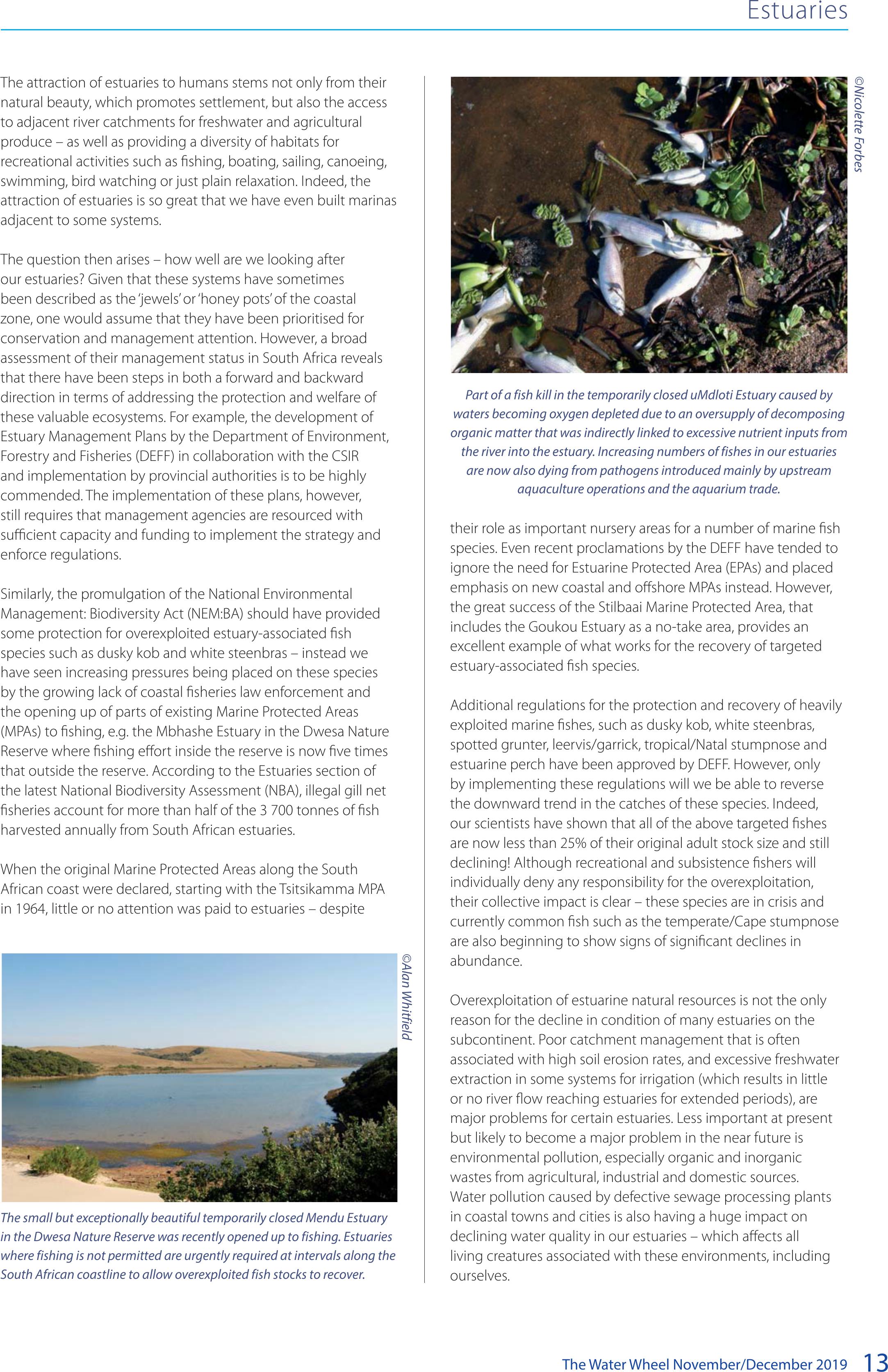
Part of a fish kill in the temporarily closed uMdloti Estuary caused by
waters becoming oxygen depleted due to an oversupply of decomposing
organic matter that was indirectly linked to excessive nutrient inputs from
the river into the estuary. Increasing numbers of fishes in our estuaries
are now also dying from pathogens introduced mainly by upstream
aquaculture operations and the aquarium trade.
©Nicolette Forbes
The small but exceptionally beautiful temporarily closed Mendu Estuary
in the Dwesa Nature Reserve was recently opened up to fishing. Estuaries
where fishing is not permitted are urgently required at intervals along the
South African coastline to allow overexploited fish stocks to recover.
©Alan Whitfield
BACK TOP TOP

The Water Wheel November/December 2019
14
Estuaries
Although excellent legislation exists to prevent pollution from
entering rivers and estuaries, there are disturbing signs that
the implementation of that legislation is being compromised
by a number of factors, including the lack of maintenance of
sewage processing plants by municipalities, inadequate financial
resources in environmental law enforcement agencies, and the
shortage of skilled human resources to document and prosecute
parties guilty of environmental degradation. The increasing
levels of metals and persistent organic pollutants (POPs) in the
flesh of fishes from certain estuaries, which has led to local
authorities such as eThekweni Municipality recommending a fish
consumption of less than 200 g per month of fish captured in
Durban Bay, is not the way to go.
Heavy rains in KwaZulu-Natal during early 2019 have highlighted
the massive waste plastic loads that are carried into our estuaries
and the sea. Although a superficial solution may be to remove
the large plastic items and megaplastic fragments for recycling,
increasing evidence is showing that microplastics, which cannot
be easily recovered from the environment, are becoming
incorporated into aquatic food chains. Thus, everything from
small invertebrates and shrimps, to prawns and fishes that
we consume are eating microplastics and, in effect, putting
pollution on our plates!
There is, however, good news relating to these jewels in our
coastal crown. South Africa has 290 estuaries, including the
large Lake St Lucia system which is a designated Ramsar and
World Heritage Site. Indeed, St Lucia on its own accounts for
approximately 50% of the estuarine area in South Africa and is
also one of the largest estuaries in Africa. This system is in the
process of being rehabilitated by the iSimangaliso Wetland Park
Authority after the devastating consequences of the removal
and canalisation of the Mfolozi Swamps in the 1950s and the
separation of the Mfolozi River from the St Lucia Estuary for more
than half a century. If the system receives excellent summer rains
in 2019/20 we may once again see a fully functional St Lucia
Estuary and vibrant lake system contributing as a major fish
and prawn nursery area for a variety of important commercial,
recreational and subsistence coastal fishery species.
Although only 1% of South Africa’s estuarine area is well
protected, several unprotected estuarine types (from a fish
perspective) could be transferred to the well protected category
simply by improving fishery management and water quality
issues. For example, according to the recent NBA Report on
Estuaries, 32% of South Africa’s estuaries and 10% of the total
estuarine area could be categorised as well protected if fishing
effort in just three estuaries (Kosi, Knysna and Langebaan) was
better controlled.
Fortunately, there are some near pristine estuaries in the more
remote parts of the Eastern and Western Cape Province – but
growing human populations, especially in the former area,
will inevitably place increasing pressures on the biodiversity,
productivity and viability of these few remaining estuarine ‘gems’.
We therefore need to grasp the present window of opportunity
to declare new EPAs that will be made accessible to people
for non-destructive and non-consumptive recreational and
ecotourist activities and, at the same time, ensure sustained
prawn, crab and fish production for the future.
Scientific research in estuaries over the past half century, and
especially during the last three decades, has unequivocally
shown that our fish stocks are declining rapidly, mainly due
to overfishing but also linked to increasing environmental
degradation. The latest NBA Assessment Report for South African
estuaries indicates that more than 63% of the estuarine area
in the country is heavily or critically modified, with important
ecological processes under severe pressure. According to the
above report, compiled by leading South African estuarine
scientists, this trend has negative consequences for coastal
productivity, fisheries livelihoods, food security, property values
and recreational enjoyment.
“Illegal gill net sheries account for
more than half of the 3 700 tonnes of sh
harvested annually from South African
estuaries.”
In summary, we are faced with a ‘low catch road’ or ‘high catch
road’ with regards to estuarine fisheries management. The high
catch road scenario is characterised by the following six main
attributes:
• Fisheries regulations rigorously enforced by dedicated
staff, especially the removal of all illegal gill nets from our
estuaries.
• Environmental legislation fully implemented by the relevant
authorities.
• Implementation of the Environmental Water Reserve for
estuaries by the Department of Water and Sanitation (DWS).
• Creation of a network of EPAs for fishes, especially for
currently overexploited species.
• EMPs that include no-take zones are prioritised and
implemented for all major estuaries.
• Improved angler awareness and compliance with
regulations, including greater adoption of catch and release
fishing within all recreational sectors.
©Stywe Lyne/Tight Lines and Tor Naesje
Dusky kob shown here are targeted by both recreational and subsistence
anglers in estuaries, significantly declining in both average size and
number as a result of decades of overfishing and, more recently,
widespread environmental degradation. The average size of dusky kob
from illegal gill nets recovered in KwaZulu-Natal estuaries is now only 30
cm, whereas this species becomes mature at 1 m in length.
BACK TOP TOP
The Water Wheel November/December 201915
Estuaries
The low catch road below has a similar set of six bullets that
need to be avoided at all costs if we want a sustainable future for
our estuarine and coastal fisheries:
• Lack of fisheries regulations enforcement and increase in
gill net poaching in estuaries.
• Poor implementation of environmental legislation by
provincial and national authorities.
• Lack of implementation of the Environmental Water
Reserve for estuaries.
• Ineffective protected areas that allow fishing and
an absence of new EPAs to support the recovery of
overexploited fish species.
• The rollout of EMPs is slow and ineffective in terms of
implementation.
• Anglers remain poorly informed and mainly non-compliant
in terms of fishery regulations, with catch and release
fishing confined to an absolute minority of recreational
anglers.
In conclusion, with the scientific evidence before us, can we
afford not to take the high catch road?
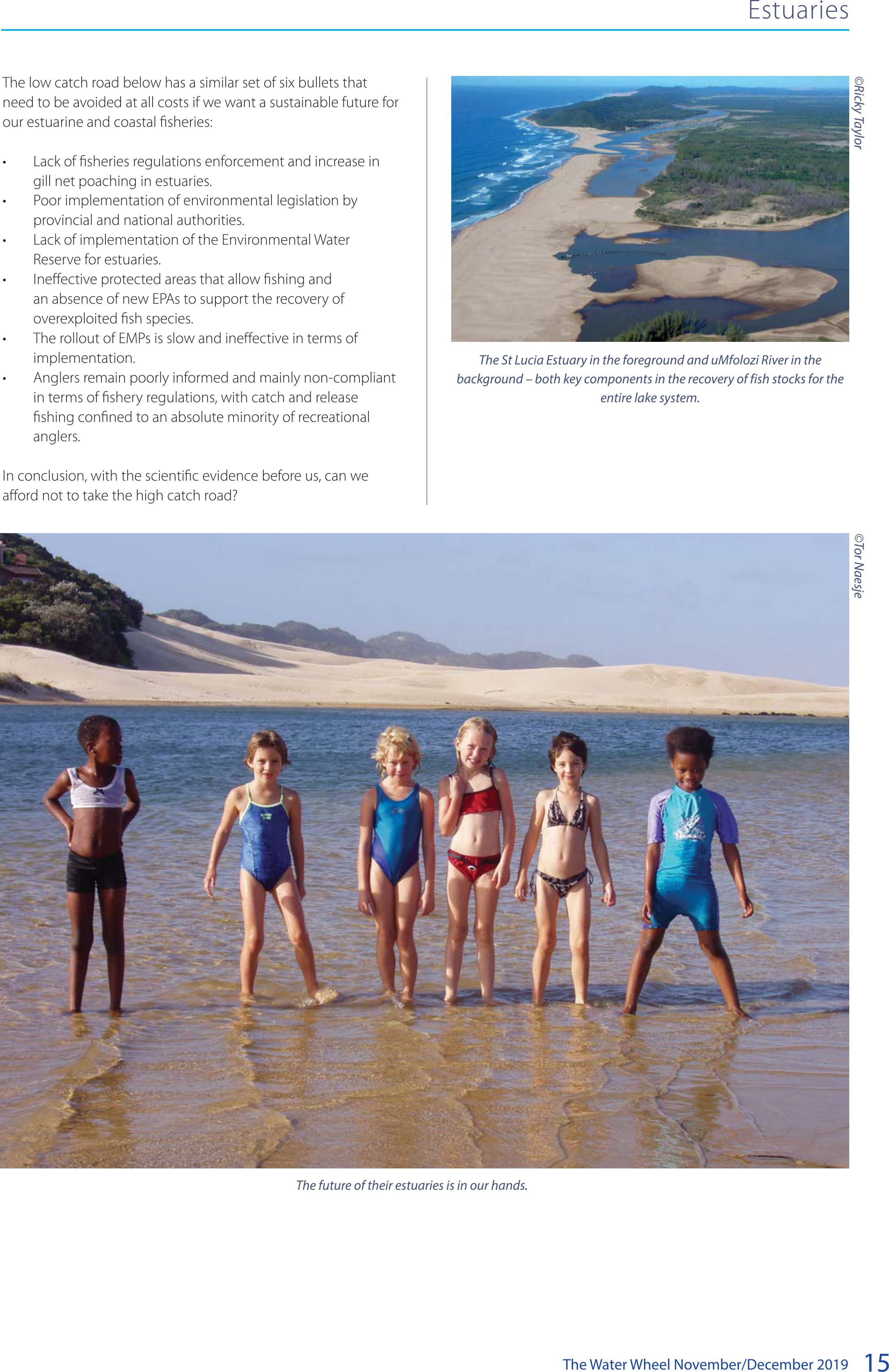
The St Lucia Estuary in the foreground and uMfolozi River in the
background – both key components in the recovery of fish stocks for the
entire lake system.
The future of their estuaries is in our hands.
©Tor Naesje©Ricky Taylor
BACK TOP TOP

The Water Wheel November/December 2019
16
Feature
WATER AND THE ENVIRONMENT
The endangered giant redfin (Pseudobarbus skeltoni) is doing
better than expected in the Riviersonderend catchment, and
palmiet seems to be linked to the health of endemic fish
populations in the area.
Scientists have also documented an unexpected recovery of
native fish populations in the lower Du Toits River, possibly due
to the disappearance of alien invasive fish during the recent
multi-year drought in the region. The lower catchment was also
recently cleared of invasive alien plants.
These and other surprising results became known during a
recent study of the upper Riviersonderend, Amandels and Du
Toits rivers in the Western Cape’s Riviersonderend catchment
area.
The catchment supplies water to the Theewaterskloof Dam,
the largest reservoir in the Western Cape Water Supply System
(contributing 53% of the City of Cape Town’s supply). This
catchment is also in the heart of the Boland strategic water
source area. These mountain catchments, primarily situated in
Cape’s endemic fish swimming for survival
A recent assessment of freshwater biodiversity in the Western Cape’s Riviersonderend catchment
provides new insights into the state of endemic freshwater sh species in the area. Jorisna
Bonthuys reports on some of the ndings.
The study area.
BACK TOP TOP

The Water Wheel November/December 201917
the Cape Fold Mountains, operate as the ‘water pumps’ of the
province. From here, water gets distributed across the landscape
via rivers, dams and pipelines into our taps.
This catchment is situated in the southwest fynbos bioregion,
which supports the highest level of endemism of wetland plant
species in the whole of South Africa.
But it is not only unique fauna that matters in the region – the
region’s endemic fish populations are important too. This is
the view of Kate Snaddon and Dr Jeremy Shelton from the
Freshwater Research Centre (FRC) who participated in research
in the area. The study, funded by The Nature Conservancy, is
part of ongoing work to prioritise wetland restoration and other
efforts to support water security in the Greater Cape Town area.
The Freshwater Research Centre’s team of researchers compiled
a document titled A Baseline Assessment for Freshwater
Biodiversity Conservation in the Riviersonderend Catchment,
South Africa: Threats and Interventions Report.
The research aims to develop an overarching catchment
‘picture’ of water use and biodiversity pressure points in the
area, Snaddon explains. Twenty-two baseline river monitoring
sites were selected as part of the study. These were surveyed in
December 2018 and March 2019. Data on the fish species were
collected using a combination of sampling methods, namely
snorkel surveys, fyke netting and electro-fishing.
A delicate balance
The Riviersonderend catchment has been identified as a
freshwater ecosystem priority area due to the rivers’ good
condition and the presence of endemic freshwater species.
The water quality in the catchment’s rivers is generally good,
particularly in the upper reaches of all three rivers. However,
as these rivers leave their pristine headwater catchment areas,
they are exposed to human activity (primarily due to agricultural
activities), and the water quality deteriorates. “This situation
needs to be monitored to ensure that the quality of water
entering Theewaterskloof Dam is as high as possible,” Snaddon
says. “Water quality in these rivers also affects the sustainability
of freshwater biodiversity and the livelihoods of communities
within the catchments.”
The study area is considered a hotspot for freshwater fish
endemism and conservation in the region. The catchment
provides sanctuary for the endangered giant redfin, among
others. This Breede River-endemic species is known from just
three tributaries, Dr Shelton points out.
The study provides the first data on population extent and
structure of the endangered giant redfins in the upper
Riviersonderend. The species was found to inhabit 4.64 km of
the upper Riviersonderend River, from a few hundred metres
downstream of the CapeNature reserve boundary up into the
remote and rugged Sonderend Mountains.
The researchers documented a healthy population of giant
redfins in the upper Riviersonderend River, Dr Shelton indicates.
Yet, despite its relatively large distribution in the study area, the
giant redfin’s survival is still threatened, including by pressures
Water and the environment
The endangered Breede River redfin. This iconic freshwater endemic species thrives in rivers where habitat conditions are favourable
and human-linked impacts minimal.
Jeremy Shelton
BACK TOP TOP

The Water Wheel November/December 2019
18
Water and the environment
on its habitat. The reach downstream of the gauging weir, which
appears to be an important source habitat for these endemic
fish, is under pressure from invasive alien plants, for instance,
which could reduce streamflow and habitat complexity.
Dealing with invasive alien plants in the area could be vital
for the well-being of the giant redfins and the other endemic
species inhabiting the upper Riviersonderend River, according to
the researchers.
Why palmiet matters for fish
A total of 40 wetlands were mapped in the catchments studied,
covering an area of 2 266 hectares. A large proportion of these
wetlands are made up of palmiet beds. This unique wetland
plant has been described as an ‘ecosystem engineer’ due to
its ability to slow down water flow and trap sediment. But
in addition to its important ecosystem-level role of trapping
sediment and slowing down water flows, palmiet could also be
important as habitat for native fish and as a dispersal barrier to
non-native fish present in the dam downstream.
In both the upper Riviersonderend and Du Toits rivers, thick
palmiet beds appear to play a role in restricting non-native fish
distributions. They may prevent the alien fish from dispersing
from the dam upstream into important native fish habitats, Dr
Shelton explains. Further research is required to test this theory.
Native fish like the Galaxias spp. may use the palmiet to shelter
from predation by larger fish species, and might also feed on
invertebrates associated with palmiet. Similarly, thick palmiet
beds may be preventing re-invasions of non-native fish species
in the Sonderend River.
The Galaxias sp. zebratus rectognathus, known only from the Amandel and Du Toit rivers in the upper Riviersonderend catchment
in the Western Cape.
Jeremy Shelton
BACK TOP TOP

The Water Wheel November/December 201919
It is likely that palmiet, which dominates the middle to lower
sections of both the upper Sonderend and the Du Toits
Rivers, also plays an important role in both the hydrology
and geomorphology of these ecosystems. The palmiet in this
catchment is, however, under threat from a range of human
impacts, including land-use practices and groundwater
extraction. This could impact negatively on biodiversity and
ecosystem function in the catchment, the researchers indicate.
Native fish recolonise a river
Historic data indicate that, while known to be abundant
upstream of the old government weir on the Du Toits River,
native fish have been scarce or absent downstream of the
gauging weir in recent decades, probably due to predation by
non-native predatory fish like black bass.
“Snorkel-based fish abundance estimates in the Du Toits River,
however, shows native fish are now quite abundant downstream
of the weir, indicating recolonisation and recovery of the native
species in this section, perhaps in response to the absence of
non-native fish,” Dr Shelton says.
Possible reasons for the disappearance of non-native black
bass (Micropterus spp.) from the lower Du Toits River include
impacts of drought and predation by sharptooth catfish, he
says. More research is, however, needed to confirm these
suspicions. The researchers point out that the (re)introduction
of the endangered Berg-Breede River whitefish (Pseudobarbus
capensis), which likely occurred in this section of river before
bass invaded it, should also be considered.
The heat is on
The severe multi-year drought in the Western Cape (2015-2017)
recently provided a unique window into what the world could
look like in the Western Cape over the next few decades in the
context of climate change. “The drought provided us with a
glimpse of conditions expected to become a lot more common
in the decades ahead,” Dr Shelton says.
New research by the FRC in partnership with the South African
Institute for Aquatic Biodiversity (SAIAB) shows just how sensitive
many of these threatened endemic fish species are to changes
in water depth, streamflow and rising temperatures. “Drier
conditions and a lack of water security also have an impact on
the Cape’s endemic fishes,” he explains. “The Western Cape is
especially vulnerable to reduced rainfall and rising temperatures
that global change models predict.”
The Breede River redfin seems particularly vulnerable in a
warmer world. “Already, its current distribution patterns are
fragmented,” Dr Shelton indicates. The research shows that this
species is likely to become extinct under fairly conservative
climate change scenarios.
“The extinction threat is quite high for some of these fishes
and we must conserve them as best as we can,” Snaddon
adds. “Water security not only matters to people, but also to
biodiversity in the area – a delicate balancing act that now
requires urgent attention.”
River health, water flow remains key
The main purpose of the project was to establish baseline
patterns in biota, aquatic habitat condition (including flow) and
river health, Dr Shelton highlights. Future work in the area should
build on this foundation by continuing to track changes in these
freshwater ecosystems, particularly in response to key threats like
invasive species, climate change and over-abstraction.
“In the face of uncertainty, it is clear that the need to balance
human water use and environmental water requirements is
about to become a whole lot more complex,” adds Dr Bruce
Paxton, a flow specialist at the FRC. “Surveys show habitat is
being lost, and our research shows how sensitive the species
are to changes in the environment, and our distribution models
show the risk of species extinction during this century,” Dr Paxton
says.
Good water quality is particularly important in the
Riviersonderend catchment due to the livelihoods that depend
on agriculture and the fact that the rivers in this catchment feed
into the Theewaterskloof Dam.
One of the most significant findings of this study was that
Galaxias rectognathus appears to use fast flowing riffles
and runs which is unusual for a Galaxias, which are more
commonly associated with slow-flowing river reaches and
marginal vegetation. “It demonstrates how little we know about
these species and how much we still have to learn,” Dr Paxton
summarises. “It is especially important considering that shallow
fast-flowing habitat is relatively scarce living-space in a river
and usually the most sensitive to flow reductions and water
abstraction.”
Water and the environment
More about the upper Riviersonderend catchment
• The catchment rises on the Groot Drakenstein
Mountains and flows eastwards through the
Riviersonderend Gorge within the Hottentots
Holland Nature Reserve. As the river leaves the
reserve, it enters a 222-hectare palmiet valley-bottom
wetland.
• Most of this wetland has been classified as an aquatic
critical biodiversity area in the Western Cape Spatial
Biodiversity Plan for the Theewaterskloof Municipality.
• This catchment has been identified as a freshwater
ecosystem priority catchment due to the good
condition of the river and the presence of endemic
and threatened freshwater species.
• The upper reaches of the Riviersonderend catchment
provide sanctuary to the endangered giant redfin
(Pseudobarbus skeltoni) which is endemic to the
Breede River and known from just three tributaries.
• The river is also home to the Breede River
redfin (Pseudobarbus sp. ‘burchelli Breede’), the
Riviersonderend catchment endemic Cape kurper
(Sandelia capensis sp. ‘Riviersonderend’) and three
genetically distinct lineages of Cape galaxias and
Galaxias zebratus (one of which is endemic to the
Riviersonderend catchment).
BACK TOP TOP

The Water Wheel November/December 2019
20
Water and the environment
Dr Bruce Paxton with endemic giant redfin.
Given the highly-threatened status of the majority of indigenous
fish in the province, there is a need to prevent new invasions
while managing the impacts of invasions in priority areas. Once
established, the management of alien invasive fish is complex,
and few methods exist that will result in complete eradication.
“It remains critical to investigate and model the effects of water
quality, water flow and the effects of climate change on our
aquatic ecosystems to inform water resource management and
policy,” Snaddon concludes.
Visit http://frcsa.org.za for information
The Cape kurper population in the Riviersonderend catchment is genetically distinct from those elsewhere in the Breede River system. It is currently being
reclassified as a separate species.
Did you know?
• The freshwater fish fauna of the Cape fynbos region
is characterised by low species diversity (23 species)
and high endemism (20 species), with several
species restricted to very small geographic ranges
• Fourteen of the 20 fishes endemic to the region
are considered ‘vulnerable’, ‘endangered’ or ‘critically
endangered’ by the International Union for
Conservation of Nature (IUCN)
• Human-linked degradation of aquatic habitats,
including the introduction of non-native freshwater
fishes and water abstraction, has caused dramatic
decreases in the distribution and abundance of
many of these species over the last century
• Invasive alien species remain the biggest threat to
many indigenous fish species in the province, but
now climate change is also starting to take its toll
• Research using molecular techniques has revealed
that the fynbos region’s freshwater fish diversity has
probably been severely underestimated. Species
previously thought to be widespread are now being
split into species complexes consisting of several
genetically unique lineages. Many of these species
might occur over very small distribution ranges,
some limited to single catchments or streams.
Source: The Nature Conservancy and CapeNature
Jeremy SheltonJeremy Shelton
BACK TOP TOP

The Water Wheel November/December 201921
Gough: The remote island that all South Africans depend on
Every October, a small crowd gathers at the East Pier Quay at
Cape Town’s Waterfront to welcome the SA Agulhas II back
home again. As one of only five official gateway cities to the
Subantarctic and Antarctic regions, the ship docks in Cape Town
a number of times a year. Except for research missions, it ferries
teams and equipment to and from the South African National
Antarctic Programme (SANAP) stations.
Each May, the ship returns with staff from Marion Island,
where South Africa constructed its first scientific base in the
Subantarctic. In February, the ship returns from the Antarctic
station. Though the entire region is one of extreme weather
and daunting landscapes, the October voyage, however, marks
the return from one of the most remote places on Earth with a
constant human presence. It’s called Gough Island. With it, the
SA Agulhas II brings the handful of South Africans that just spent
a year on a secluded volcanic outcrop, back home.
Gough is described as a lonely place. The total human
population numbers five to eight people: three meteorologists,
a doctor, a diesel mechanic and field assistants. Their mission?
To collect integral data from a weather station on the island.
Though most South Africans are unaware of the small team’s
presence on Gough, their persistent gathering of this data
benefits us all, and reverberates far beyond the borders of the
country.
How South Atlantic island has become critical to weather forecasting in South Africa, and beyond.
Article by Petro Kotzé.
WEATHER FORECASTING
Feature
Tom McSherry
BACK TOP TOP

The Water Wheel November/December 2019
22
Where is Gough Island?
Gough lies about 2 600 km from Cape Town, and just over
3 200 km from the point closest to us in South America. The
island is part of the Tristan da Cunha group of islands, which
lies about 400 km North West from Gough. The islands are, with
Saint Helena, British territory. Since the 1950s, South Africa has
been leasing a patch of land to run a weather station, which
is now technically a district of Cape Town. The weather station
is managed by the South African Weather Service (SAWS) and
the members of the teams stationed there are part of SANAP
.
As with all of the country’s Antarctic stations, it is administered
by the Department of Environmental, Forestry and Fisheries,
Directorate: Southern Ocean and Antarctic Support.
Gough Island is 91 km² in size, with peaks up to 900 m above
sea level. There are also small satellite islands and rocks; places
like Saddle Island, Round Island, Cone Island, Lot’s Wife, Church
Rock, Penguin Island, and The Admirals. Conditions are harsh. The
island clings onto the edge of the “roaring forties” in reference to
its location between 40° and 50° south in the South Atlantic, and
the frequent gale-force winds. Summers are cool, rain falls often
and sunshine is scarce.
This then, is where the South African team observes various
climatic parameters and keeps an eye on the automatic weather
station. Port Meteorological Officer for the SAWS (Cape Town
Weather office), Mardené de Villiers, explains that they do this in
24 hours shifts, 365 days a year.
Gough Island and weather forecasts
The automatic weather station includes temperature and
humidity sensors, a wind sensor and a pressure sensor, explains
de Villiers. All other parameters are measured by the observer on
duty, one of the three meteorologists based on Gough. They log
parameters of temperature, humidity, pressure, wind speed and
direction, horizontal visibility, cloud height and type, present and
past weather, and rainfall.
Twice a day they also launch a weather balloon into the upper
atmosphere. Attached is a radiosonde, a battery powered
telemetry instrument to measure various atmospheric
parameters and transmits them by radio to a ground receiver.
De Villiers explains that the balloon’s flight into the upper air
provides a crucial vertical profile of the atmosphere. Here, the
instruments collect real-time temperature, humidity, pressure
and wind speed and direction.
Last, she says, they also monitor data from a mounted weather
buoy on Tristan da Cunha, where valuable atmospheric pressure
data is collected.
The weather station thus operates much in the same way as
others across South Africa, which also commonly provides hourly
climate observations and upper-air ascents (collecting data with
weather balloons). Yet, the volcanic island’s location makes the
data from here particularly important.
Data from the west
The majority of the weather systems affecting South Africa
originate to the west of the country, says SAWS Senior Forecaster,
Kate Turner: “This is because the predominant wind flow that
governs these weather systems is from west to east, which
results in the weather systems affecting South Africa moving in
the same direction.” As a result, it is crucial to have data stream to
the west of South Africa to understand and gather information
of the approaching weather, she explains.
Looking to what lies to the west of country, the choices of
locations for weather stations are severely limited. In fact, the
whole region is described as “extremely data sparse for climate
studies” and Gough is one of the few locations filling this gap.
Turner explains that the data from Gough is not only beneficial
for information on approaching weather systems, but also for a
better, 3D picture of the atmosphere at that specific time. This
data gets fed into numerical models for an indication of the state
of the atmosphere, she says. “The more data points we have from
across the southern African domain, including land and ocean,
to “colour in” and map the current state of the atmosphere, the
better the model forecast will be.” If you do not have good and
Weather forecasting
The Subantarctic
According to the Scientific Committee on Antarctic Research (SCAR), the Subantarctic area includes islands from c. 40°S (e.g.
Gough Island) to those south of the Antarctic Polar Front (e.g. South Georgia, Heard Island). It includes large portions of the
Southern ocean and some of the only land between 35°S and 60°S. For the purposes of SCAR, in 1958 “Antarctica” was defined
as being bounded by the Antarctic convergence, as well as the Subantarctic islands on which International Geophysical
Year observations were being made (which included Gough Island). The Australian Antarctic Division defines the Antarctic
convergence as the region of the Southern Ocean encircling Antarctica, roughly around latitude 55 degrees South (but
deviating from this in places) where the cold waters of the Antarctic circumpolar current meet and mingle with warmer
waters to the north.
Approaching Gough Island on the research vessel.
Julius Kette
BACK TOP TOP

The Water Wheel November/December 201923
sufficient data to feed into the models, she says, you cannot
expect good, high quality forecasts.
As such, the data from Gough is integral for weather forecasts
across southern Africa, and for warnings of looming severe
weather.
Turner further points out that the data gathered from Gough
and other stations over the decades is “extremely important”
not only for research purposes, but also to understand climate
conditions and to map changes to the climate over time.
The impact of the data ripples across and beyond South Africa.
First, it is used for direct day-to-day forecasting for the island
itself and particular operations that require an indication of the
weather, says de Villiers. Then, the data from Gough is vital to
forecast weather across southern Africa. “The data is also sent
to the Global Telecommunication System (GTS) where various
international users access it to be incorporated into global
weather models.” Last, it is also used for various research projects.
Now reaching back over half a century, the data set from Gough
has become indispensable to local and international climate
studies, as it is for the everyday lives of countless South Africans.
We access the fruits of their labour easily. We can see it every
time we check the weather forecast online, open the newspaper
or watch it over the news.
However, the effort to obtain the data is more obscure. Digging
into the archives of the Antarctic Legacy of South Africa, our
history in the region is marked by great scientific achievement,
as well as tales of “mutiny, attempted murder, shipwreck,
drownings and much more,” as written by Lieut. Frank McCall,
who led the first missions to build South Africa’s weather stations
in the region.
South Africa’s rich history in the Antarctic and
Subantarctic region
South African activities in the Antarctic already began in the
previous century, when sealers launched their ships there from
Cape Town. However, the national flag of the Union of South
Africa was formally raised on Marion Island for the first time on
29 December 1947. The feat was part of operation Snoektown,
a naval operation during which the uninhabited, Subantarctic
archipelago of the Prince Edward Islands was officially annexed
by South Africa.
According to McCall, “The story begins in 1954 when Jannie
Smuts, the Prime Minster of South Africa, sent a confidential
message to certain scientific authorities warning that South
Africa had better occupy the Prince Edward Islands before
Russia did. This would be by means of a weather-research
station.” Volunteering for the job, McCall wrote of “a lonely, wild,
volcanic island halfway to the Antarctica mainland,” where they
subsequently put a small group of weathermen in a tiny hut.
“They were the only human inhabitants,” he wrote. “This was
Marion Island.” At least one relief expedition per year to the
weather station on Marion has been carried out ever since.
Weather forecasting
As was required by the Weather Service, the weather balloon is released on Gough Island twice a day (photo taken in1968).
BACK TOP TOP

The Water Wheel November/December 2019
24
Motivation for the establishment of the next weather station,
on Gough, was driven by the International Geophysical Year of
1957/58. The initiative entailed scientists from around the world
taking part in a series of coordinated observations of various
geophysical phenomena. Activities spanned the globe from the
North to the South Poles, but special attention was given to the
Antarctic (see sidebar on definition of the area), where research
on ice depths yielded radically new estimates of the Earth’s
total ice content. The research also contributed to improved
meteorological prediction, advances in the theoretical analysis of
glaciers, and better understanding of seismological phenomena
in the Southern Hemisphere.
“Data gathered from Gough and
other stations is extremely important not
only for research purposes, but
also to understand climate conditions
and to map changes to the climate over
time.”
In preparation, the weather station was established on Gough in
1956, to be operated by South Africa. McCall writes of a mission
to “work out where to put a base on that uninhabited island
which lies south of Tristan Da Cunha.” Pending the building of
the base, he writes, some weathermen were left there in a small
hut. McCall writes that on his return six months later, the leader
was “raving”. “He had tried to exercise authoritarian rule over his
group and they “sent him to Coventry” (refused to talk to him.)”
A weather station was consequently built at a place called ‘The
Glen’, and later moved to the South Western lowlands of the
islands (in 1963) for more accurate weather observations.
South Africa has paid expensively for its presence on Gough.
According to a History of South African involvement in Antarctica
and at the Prince Edward Islands by J Cooper and RK Headland,
“Gough Island may be reckoned as a dangerous place: four team
members have died there since 1956, three by exposure in the
mountains and one by drowning while fishing.”
SANAP’s last scientific station was built on the Antarctica
mainland in 1961. First called Norway station, it was later
renamed South African National Antarctic Expedition (SANAE)
and has been in continuous operation since. The current South
African research base, SANAE IV is located at Vesleskarvet, Queen
Maud Land.
Though it cannot be described as a hospitable environment
to humans, Gough Island is special for various reasons beyond
meteorology. It’s a UNESCO Natural World Heritage Site, a Ramsar
Wetland of International Importance and part of the Tristan da
Cunha Nature Reserve. It’s also been declared an Important Bird
and Biodiversity Area, and is considered home to one of the
most important seabird colonies in the world.
The other inhabitants of Gough
Gough Island is one of the only homes to the critically
endangered Tristan Albatross. January dated newsletters written
Weather forecasting
A Tristan Albatros during mating season.
Tom Mcsherry
BACK TOP TOP

The Water Wheel November/December 201925
Weather forecasting
by those stationed there, tell of the interior of the island dotted
with white birds nested on mounds that hold their enormous
white eggs. While the Tristan Albatross is perhaps its most
famous avian inhabitant, the island is also home to almost the
entire global breeding populations of the endangered Atlantic
Petrel and MacGillivray’s Prion.
These are some of the 22 breeding seabird species found on
Gough Island. It’s also home to 35% of the population of the
endangered Sooty Albatross, and about 20% of the endangered
Atlantic Yellow-nosed Albatross.The Gough Finch and Gough
Moorhen are endemic to the island.
Unfortunately, the birds are paying a price for human habitation
of the island. Docking at Gough in the 19th century, house mice
reportedly arrived with those sealers. They are famously big,
having grown substantial larger than house mice elsewhere
due to the favourable conditions the island offers. There
are no natural predators or competition for the food that’s
available in ample supply. Especially in winter, this takes
the form of vulnerable Tristan Albatross and Atlantic Petrel
chicks. Bird numbers have dropped dramatically as a result. In
partnership with the Royal Society for the Protection of Birds,
the Department of Environmental, Forestry and Fisheries is
launching a mice eradication programme in 2020.
The island is not completely out of bounds to South Africans. As
per agreement, the annual Gough Island relief voyage with the
SA Agulhas II also takes paid passengers to Tristan die Cunha on
its outward and return voyage, stopping at Gough along the
way. For most of us however, the near imperceptible connection
to Gough remains to be via our everyday weather forecasts.
Inspecting the Stevenson screen in 1978.
Sources:
• History of South African involvement in Antarctica and at
the Prince Edward Islands by J Cooper and RK Headland
(S. Afr. Antarct. Res., Vol 21 No 2, 1991)
• Where is Antarctica, by Lieut. Frank McCall, 1955 (general
report on his visits to Antarctica and Sub-Antarctic islands.)
• https://www.environment.gov.za/projectsprogrammes/
antarctica_southernoceans_islands
• The Antarctic Legacy of South Africa archives (http://blogs.
sun.ac.za/antarcticlegacy/)
• The impacts of introduced House Mice on the breeding
success of nesting seabirds on Gough Island by Anthony
Caravaggi, Richard J. Cuthbert, Peter G. Ryan, John Cooper
and Alexander L Bond, published in the Ibis International
Journal of Avian Science: , 22 October 2018
• http://www.nas.edu/history/igy/
• Thanks to the Antarctic Legacy of South Africa (ALSA) for the
photographs used in this article.
BACK TOP TOP

The Water Wheel November/December 2019
26
Feature
AGRICULTURE AND WATER
The agricultural sector finds itself in “a serious predicament”,
according to University of Witwatersrand (Wits) Prof Mike Muller.
“Agriculture needs to manage uncertain climates – both in
terms of weather and politics,” he explained. Prof Muller, adjunct
professor at the School of Governance, highlighted the need
for good water management at a recent Agri SA symposium in
Somerset West.
As a former director-general of the Department of Water Affairs
and Forestry (now Water and Sanitation), Prof Muller spoke of the
need for South Africa to assume a “capable and developmental
state” when it comes to managing its water resources. Prof Muller
and other participants urged the Department of Water and
Sanitation to implement the National Water Act (Act 36 of 1998),
something successive administrations have failed to do in the
past.
The availability and quality of water resources for agriculture
remain under threat, according to Janse Rabie, Agri SA’s policy
head for natural resources. This calls for immediate attention,
given the undisputed importance of the agricultural sector to
South Africa’s economy.
In 2017, for instance, Western Cape agriculture generated R45
billion for the economy. Agriculture sustains a R530 billion
economy that employs 2,4 million of the province’s 6,4 million
Agriculture’s water challenges – Digging for solutions
Taking into account
future uncertainties,
how can South Africa
ensure that it uses
its water resources
sustainably whilst
promoting economic
development and
food security? Jorisna
Bonthuys reports on the
proceedings of a recent
water symposium
hosted by Agri SA where
this topic featured
strongly.
BACK TOP TOP
The Water Wheel November/December 201927
citizens. Moreover, 45% of South Africa’s agricultural exports
come from the Western Cape. According to provincial MEC,
Dr Ivan Meyer, agriculture also employs 16% of the labour force
in the province, of which 231 000 people are agricultural workers
and 250 000 work in agricultural processing.
A climate of change
Planning for a sustainable agricultural future remains key, given
current and future realities. With the added pressures of climate
change, population growth, the pollution-induced decline in
water quality, failing municipal infrastructure and service delivery
issues, the need for improved management of water resources is
more critical than ever before.
Climate change prediction models suggest that average
temperatures will rise and rainfall events will become more
infrequent but also more intense, thereby increasing the
unpredictability of (water availability for) agricultural production.
The risk of more frequent extreme events, including floods and
droughts, is also on the rise.
Many of South Africa’s major metropolitan municipalities would
be at risk if there were to be a serious multi-year drought.
Gauteng has already been warned of a looming ‘Day Zero’
scenario in which the taps could run dry.
As the country’s water resources become more constrained,
the amount of water allocated to irrigation (~60% of total
national water use) will come under increasing pressure, Prof
Andries Jordaan indicated. Prof Jordaan, a research fellow at
the University of the Free State, recently led a comprehensive
agricultural water scenario-building process funded by the Water
Research Commission.
Water management authorities need to manage water risks
for the benefit of people, the environment and the economy.
“Rising water demands, the need for water use efficiency,
agricultural intensification and farming business all need
attention,” Prof Muller said. The challenges of agriculture
increasingly have less to do with land, people and weather than
with money, markets and management.”
“Rising water demands, the
need for water use eciency,
agricultural intensication and farming
business all need attention. The
challenges of agriculture increasingly
have less to do with land, people and
weather than with money, markets and
management.”
Agriculture and water
BACK TOP TOP

The Water Wheel November/December 2019
28
management will harm the most vulnerable (in society).”
The agricultural water scenario-building process led by Prof
Jordaan identified 65 drivers that will determine the future
of water management. These drivers have been grouped in
10 clusters, he explained. The importance of drivers and the
related clusters was determined through participatory research
and data capturing, system dynamics and game-theoretic
mathematical programming.
Four potential water management scenarios were developed.
These include a “Traditional scenario”, “Best-case scenario”, “Z
scenario” and “Frustration scenario”.
In the “Best-case scenario”, decentralised water management
is embraced by water management agencies. This scenario
requires strong governance, leadership and both public and
private involvement. There is strong enforcement of water user
guidelines, and water management authorities are efficient.
There is also good collaboration between the private sector and
the state where water is concerned. This enables the country
to participate in and benefit from innovation in the Fourth
Industrial Revolution.
In the “Z scenario”, really a worst-case scenario, South Africa
experiences water shortages, hyperinflation and disinvestment
in agriculture. This scenario, in which there is no safety and
security in rural areas, leads to food insecurity, land grabs, and a
poor, small-scale agricultural sector. Commercial farmers relocate
to other countries and food-importing increases significantly.
At the same time, water infrastructure becomes dilapidated.
The “Day Zero” threat becomes a reality for urban areas and
agriculture during dry periods.
The “Traditional scenario” entails centralised water management
and policies, low productivity and innovation in agriculture as
well as increased competition between water users. Lastly, in
the “Frustration scenario”, the gap between the haves and the
Although agriculture is the sector that uses the most water, it
is important to highlight that it gets the “hyena’s share” of the
country’s water resources, Prof Muller said. “This is because
agriculture gets what is left over after industries, cities, Eskom
and the environment have received their allocation.
“Remember, the issuing of (a water) license is no guarantee of
supply. The sector, therefore, has to create more value from the
same amount of water. Certain agricultural industries also need
to ensure they have a social license to operate by making a
positive societal contribution.
“We also need to cooperate more with our regional neighbours
to ensure food security. Why is South Africa importing water-
intensive crops into a water-scarce country? We need to consider
what our neighbours can do better than we can.”
Pollution remains a serious problem, causing water quality
and quantity problems in various areas. Many water courses,
including major rivers are polluted by poorly managed
wastewater plants and unlicensed mining operations, Prof Muller
indicated. There is also growing concern about the impact
of water quality on markets, livelihoods and human health,
especially along the Gariep and Vaal rivers.
A glimpse of what’s to come
South Africa’s agricultural system does not function in isolation.
It interacts with developments and trends in the global, national
and local economy, society and politics. Also, the food systems
of the country – from the trade in raw materials to the final
products – are intertwined in many ways.
Various drivers and associated trends are bound to impact on
agriculture in the country, Prof Jordaan highlighted. “South
Africa’s water-related agricultural future can unfold in many ways,”
Prof Jordaan pointed out. “What we do know is that poor water
Agriculture and water
Source: Water Research
Commission
1,3 million ha
SA land surface actively
irrigated
10,2 million m3/yr
Total consumptive water
use of irrigated
agriculture
BACK TOP TOP

The Water Wheel November/December 201929
have-nots increases. Poor enforcement of policies and laws,
conflict about water use and unequal access to water could also
become more pronounced.
At this stage, Rabie said, South Africa is showing signs of heading
in the direction of the “Frustration scenario”. This underlines the
urgent need to tackle current water challenges.
Future-proofing agriculture
Agri SA identified several issues that need to be addressed if
water risks in the country are to be reduced. Progress in efforts
to tackle these issues will now be systematically tracked during
regular engagements with the government, Rabie stated.
“One of the most urgent matters is to set up all nine catchment
management agencies (CMAs) spelled out in the legislation (the
National Water Act),” Rabie said. This was supposed to have been
done in 1998, but only two of the nine have been established to
date. CMAs allow for the decentralisation of water management
through means of regional structures. This can help ensure
proper water governance and integrated planning at a local
level, Rabie indicated.
Anil Singh, Deputy Director-General in the Department of
Water and Sanitation, conceded at the symposium that the
department had failed to set up these agencies. He assured the
audience that work is underway to get these structures up and
running as soon as possible.
Another critical issue is how municipalities deal with water
quality and pollution, which is endemic in our country. It is a
huge concern for the government, Rabie indicated.
The issue of verification and the validation process of agricultural
water use also needs attention, Rabie pointed out. “Without
this information, evidence-based decision making to support a
Water Sector Transformation Charter becomes impossible,” he
said. “To make water management institutions work, you must
understand your resource, who is using it and how it is being
used.”
“Water allocation reform also needs to support land reform
efforts and water pollution that has become a national
epidemic,” Rabie indicated.
Singh indicated that the department is battling to finalise the
water allocation reform policy, which the agricultural sector has
been pushing to have completed.
He also identified declining water quality as another major
challenge for agriculture and pointed to the local government’s
failure to deal with this.
Another key challenge to be tackled is keeping water affordable.
In this regard, Agri SA is encouraged by the department’s
“willingness to listen and engage with the sector”, Rabie said. This
willingness was particularly evident during the latest raw water
tariff discussion.
Agri SA requested a water resource management charge
increase of no more than 6.5% for the irrigation sector in
2020/21. The proposed raw water use charge was accepted by
the Department of Water and Sanitation in the case of all areas
except the proposed Orange River catchment management area
where an increase of 15.66% is to be enforced in accordance
with the national water pricing strategy.
Agri SA’s proposal that water resource infrastructure charges
be capped at 16.5% for the irrigation sector was also accepted.
“This constitutes a substantial achievement, considering the
department initially proposed increases of up to 50% for
numerous areas,” Rabie indicated.
The need to improve the consistency and continuity
of leadership among the country’s water management
authorities has also been identified. Agri SA would like to see
the government issue the ‘Green Drop’ and ‘Blue Drop’ reports
regularly. The first report indicates if municipalities comply
with good wastewater discharge standards, while the second
provides information on the quality of our drinking water. The
department is obligated to release these reports annually,
which give a clear picture of the quality of South Africa’s water
resources. The last full Green Drop report that drills down into
the waste treatment plants managed by municipalities dates
back to 2011.
“These and other challenges must now be tackled urgently
and collectively,” Rabie implored. “A good starting point will
be to implement the National Water Act properly. “The key
to unlocking change in water management is to build an
inclusive culture of collaboration between the private sector and
government,” Rabie concluded.
Agriculture and water
BACK TOP TOP
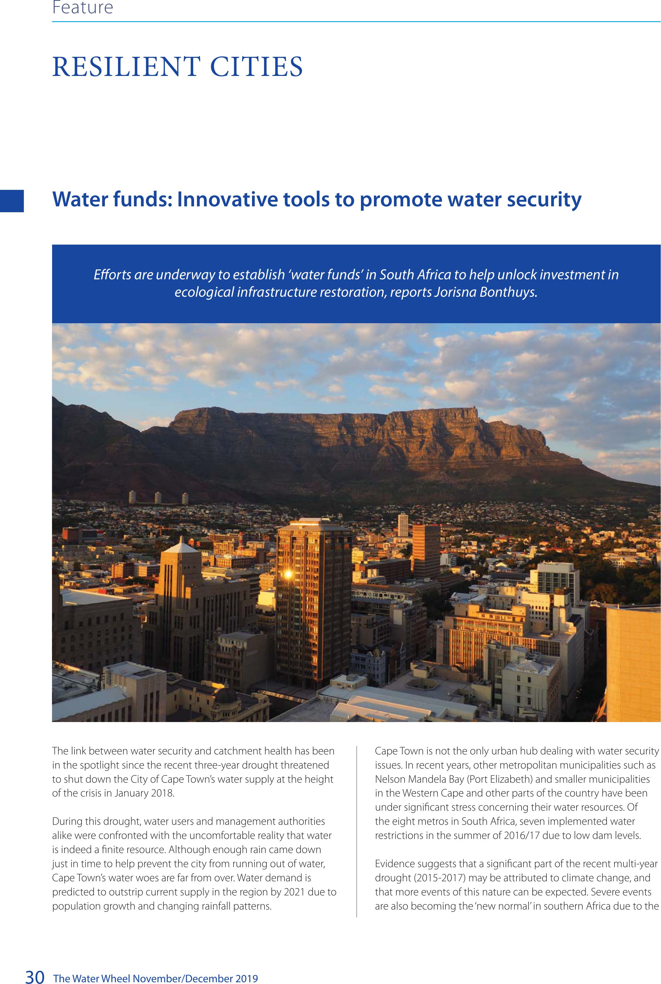
The Water Wheel November/December 2019
30
Water funds: Innovative tools to promote water security
The link between water security and catchment health has been
in the spotlight since the recent three-year drought threatened
to shut down the City of Cape Town’s water supply at the height
of the crisis in January 2018.
During this drought, water users and management authorities
alike were confronted with the uncomfortable reality that water
is indeed a finite resource. Although enough rain came down
just in time to help prevent the city from running out of water,
Cape Town’s water woes are far from over. Water demand is
predicted to outstrip current supply in the region by 2021 due to
population growth and changing rainfall patterns.
Cape Town is not the only urban hub dealing with water security
issues. In recent years, other metropolitan municipalities such as
Nelson Mandela Bay (Port Elizabeth) and smaller municipalities
in the Western Cape and other parts of the country have been
under significant stress concerning their water resources. Of
the eight metros in South Africa, seven implemented water
restrictions in the summer of 2016/17 due to low dam levels.
Evidence suggests that a significant part of the recent multi-year
drought (2015-2017) may be attributed to climate change, and
that more events of this nature can be expected. Severe events
are also becoming the ‘new normal’ in southern Africa due to the
Eorts are underway to establish ‘water funds’ in South Africa to help unlock investment in
ecological infrastructure restoration, reports Jorisna Bonthuys.
RESILIENT CITIES
Feature
BACK TOP TOP
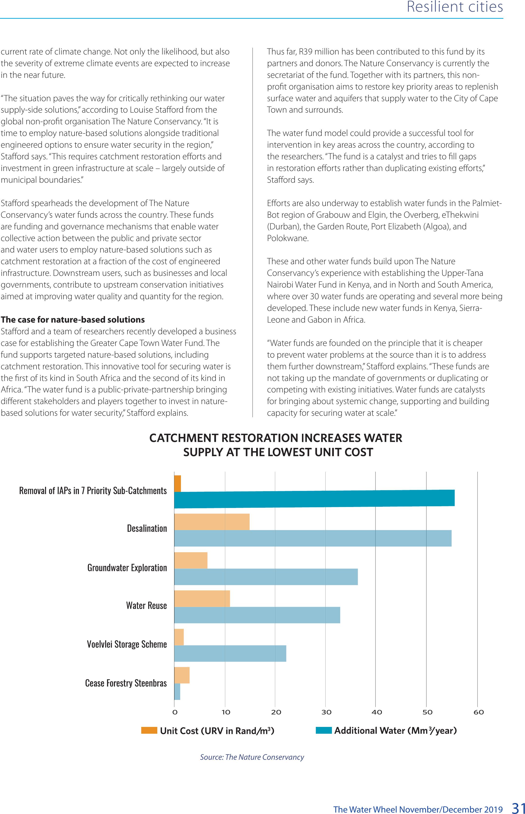
The Water Wheel November/December 201931
Thus far, R39 million has been contributed to this fund by its
partners and donors. The Nature Conservancy is currently the
secretariat of the fund. Together with its partners, this non-
profit organisation aims to restore key priority areas to replenish
surface water and aquifers that supply water to the City of Cape
Town and surrounds.
The water fund model could provide a successful tool for
intervention in key areas across the country, according to
the researchers. “The fund is a catalyst and tries to fill gaps
in restoration efforts rather than duplicating existing efforts,”
Stafford says.
Efforts are also underway to establish water funds in the Palmiet-
Bot region of Grabouw and Elgin, the Overberg, eThekwini
(Durban), the Garden Route, Port Elizabeth (Algoa), and
Polokwane.
These and other water funds build upon The Nature
Conservancy’s experience with establishing the Upper-Tana
Nairobi Water Fund in Kenya, and in North and South America,
where over 30 water funds are operating and several more being
developed. These include new water funds in Kenya, Sierra-
Leone and Gabon in Africa.
“Water funds are founded on the principle that it is cheaper
to prevent water problems at the source than it is to address
them further downstream,” Stafford explains. “These funds are
not taking up the mandate of governments or duplicating or
competing with existing initiatives. Water funds are catalysts
for bringing about systemic change, supporting and building
capacity for securing water at scale.”
current rate of climate change. Not only the likelihood, but also
the severity of extreme climate events are expected to increase
in the near future.
“The situation paves the way for critically rethinking our water
supply-side solutions,” according to Louise Stafford from the
global non-profit organisation The Nature Conservancy. “It is
time to employ nature-based solutions alongside traditional
engineered options to ensure water security in the region,”
Stafford says. “This requires catchment restoration efforts and
investment in green infrastructure at scale – largely outside of
municipal boundaries.”
Stafford spearheads the development of The Nature
Conservancy’s water funds across the country. These funds
are funding and governance mechanisms that enable water
collective action between the public and private sector
and water users to employ nature-based solutions such as
catchment restoration at a fraction of the cost of engineered
infrastructure. Downstream users, such as businesses and local
governments, contribute to upstream conservation initiatives
aimed at improving water quality and quantity for the region.
The case for nature-based solutions
Stafford and a team of researchers recently developed a business
case for establishing the Greater Cape Town Water Fund. The
fund supports targeted nature-based solutions, including
catchment restoration. This innovative tool for securing water is
the first of its kind in South Africa and the second of its kind in
Africa. “The water fund is a public-private-partnership bringing
different stakeholders and players together to invest in nature-
based solutions for water security,” Stafford explains.
Resilient cities
Source: The Nature Conservancy
BACK TOP TOP

The Water Wheel November/December 2019
32
So far, water funds have typically been established where there
are market failures. This includes situations where the price of
water does not reflect the true cost (including environmental
costs) of delivering it to users.
The Greater Cape Town Water Fund already has a strong coalition
of partners that form part of its steering committee. This list of
partners includes the Department of Water and Sanitation, the
Department of Environmental Affairs, provincial authorities,
the South African National Biodiversity Institute, CapeNature,
Nedbank, Coca-Cola Peninsula Beverages, Remgro, PepsiCo
and WWF South Africa. To date, the fund has received financial
support from PepsiCo, The Coca-Cola Foundation, Levi Strauss
& Co, the Caterpillar Foundation, Proctor & Gamble, private
individuals and foundations.
To support strategic investment in ecological infrastructure, the
fund’s steering committee has commissioned some studies,
including research to prioritise wetlands for investment in water
security through alien clearing efforts in priority dam catchments
in the Western Cape.
The fund aims to improve water security in the area that gets
water from the Western Cape Water Supply System (WCWSS)
by focusing on seven priority sub-catchments. The WCWSS is
made up of 14 dams, and three aquifers connected by a network
of approximately 11 600 km of pipelines, reservoirs, canals, and
pump stations.
From source to tap
Stafford and the team of researchers considered the return
on investment for ecological infrastructure restoration in the
WCWSS. This area includes the catchments of the six major dams
supplying water to the City of Cape Town – Steenbras Dams
(Upper and Lower), Theewaterskloof Dam, Wemmershoek Dam
and Berg River Dam.
The business case analysis modelled a 30-year period,
discounting both costs and water gains. The spotlight fell on
water quantity and the timing of flow or recharge, in particular.
“Nature-based solutions can work
alongside and complement built or ‘grey’
infrastructure to help provide sustainable
solutions for water demands”.
Cape Town’s population growth is outstripping water supply.
Resilient Cities
According to The Nature Conservancy, a water fund is “a funding and
governance mechanism that enables water users to invest collectively in
catchment restoration alongside upstream communities.
Source: The Nature Conservancy
BACK TOP TOP

The Water Wheel November/December 201933
Resilient Cities
the province. “Importantly, invasive alien plant removal would
already yield up to an additional 55 billion litres annually within
only six years,” Stafford says.
If no action is taken, water loss could double in only two
decades. Clearing invasives would also create approximately 350
jobs, according to the business case.
Over two-thirds of the catchments supplying the WCWSS are
already affected by alien plant infestations, reducing the amount
of water that reaches the rivers and dams that feed the region
by 55 billion litres (55 Mm3) per year. This equates to about
two month’s water supply for Cape Town. “Research shows the
Greater Cape Town region loses 74% of its potable water in
just 19% of its catchment,” Stafford indicates. “By focusing on
only 19% of the WCWSS and get that back in shape through
ecological restoration, we gain 74% of the current water losses as
a result of alien plant invasion.”
Investing in nature-based solutions is a “no-brainer,” Stafford
argues. “In many cases, nature-based solutions can work
alongside and complement built or ‘grey’ infrastructure to help
provide sustainable solutions for water demands.
“Long-term water security in the Greater Cape Town region, as
elsewhere, begins at the source.”
Future-proofing water supplies
While the scope of the Greater Cape Town Water Fund will be
mostly on alien invasive plant removal, efforts will also be made
to invest in other ecological interventions. These include wetland
and riparian restoration, clearing areas where forestry activities
are coming to an end, and the restoration of the Atlantis Aquifer.
This aquifer is situated on the West Coast north of Cape Town
and contributes to water security in the area.
The good news is that degraded catchments providing the
Cape’s water can be restored. “Clearing of alien vegetation has
already had a significant impact on the flow of the rivers, streams
and wetlands,” Stafford says. “But it is essential to maintain the
cleared areas to avoid invasive plants from growing back. If areas
are not maintained, the resources invested in clearing such areas
are simply wasted.”
Options such as desalination are very energy-intensive solutions
and this must be taken into consideration when making
decisions about augmenting the water supply. Current supply
augmentation solutions for the City of Cape Town are estimated
to cost R8 billion in capital costs alone, according to The Nature
Conservancy’s analysis.
“Catchment restoration is significantly more cost-effective
than other water augmentation solutions, supplying water at
one-tenth the unit cost of these alternative options,” the report
concludes.
• For more information, contact Stafford at 021 201 7391 or
Louise.Stafford@TNC.org or visit nature.org/cape-town-
water.
Invasive alien plants – including pine and black wattle – are
water-thirsty and have a significant impact on water yield in
the province. Estimates show that water resources in the Cape
Floristic Region have already been reduced by 15% due to
alien invasive plants. This could rise to 37% (from 6 765 to 4
271 million m3/year) if invasions were allowed to reach their full
extent.
There is no doubt that demand-side management is important
for water security in the region. This approach is, however,
not sufficient. “There is a need to augment the water supply,”
Staffords says. “This could be done with a combination of
catchment management and engineered infrastructure such as
raising existing dam walls to increase capacity and water reuse.”
The true cost of ‘new’ water supplies
It is important to consider the real cost and benefits of plans to
augment the city’s supply of water over time. The researchers
identified seven of the 25 sub-catchments in the WCWSS as
priority areas for alien plant removal. These areas comprise
a total of 54 300 hectares and are sub-catchments for the
Theewaterskloof, Wemmershoek and Berg River dams.
Other than demand-side management, catchment restoration
has the highest return on investment, according to their analysis.
Investing R372 million now will generate expected annual water
gains of 100 billion litres (100 Mm3) within three decades at
one-tenth of the cost of other options such as desalination and
exploration of the Table Mountain Group Aquifer. This aquifer
system has been identified as an important water source for
More about water source areas
• South Africa’s water source areas produce
disproportionately greater volumes of water
in relation to their size. Only 8% of the country
provides us with 50% of its surface run-off.
• South Africa has 22 strategic water source areas,
situated in five provinces. From here, water gets
distributed across the landscape via rivers, dams
and pipelines into our taps.
• The Western Cape holds 57% of the strategic
water resources in the country. These mountain
catchments, primarily situated in the Cape Fold
Mountains, operate as the ‘water pumps’ of the
province.
• The City of Cape Town receives 98.8% of its
water from the Boland Mountains and the
Table Mountain water source areas. The Boland
Mountain’s water source area supports more
than 4 million people.
• Only 42% of the source water areas providing
water to the Western Cape Water Supply System
are under formal protection. This system delivers
water to Cape Town and surrounds.
Source: WWF South Africa, Centre for Environmental and
CapeNature.
BACK TOP TOP
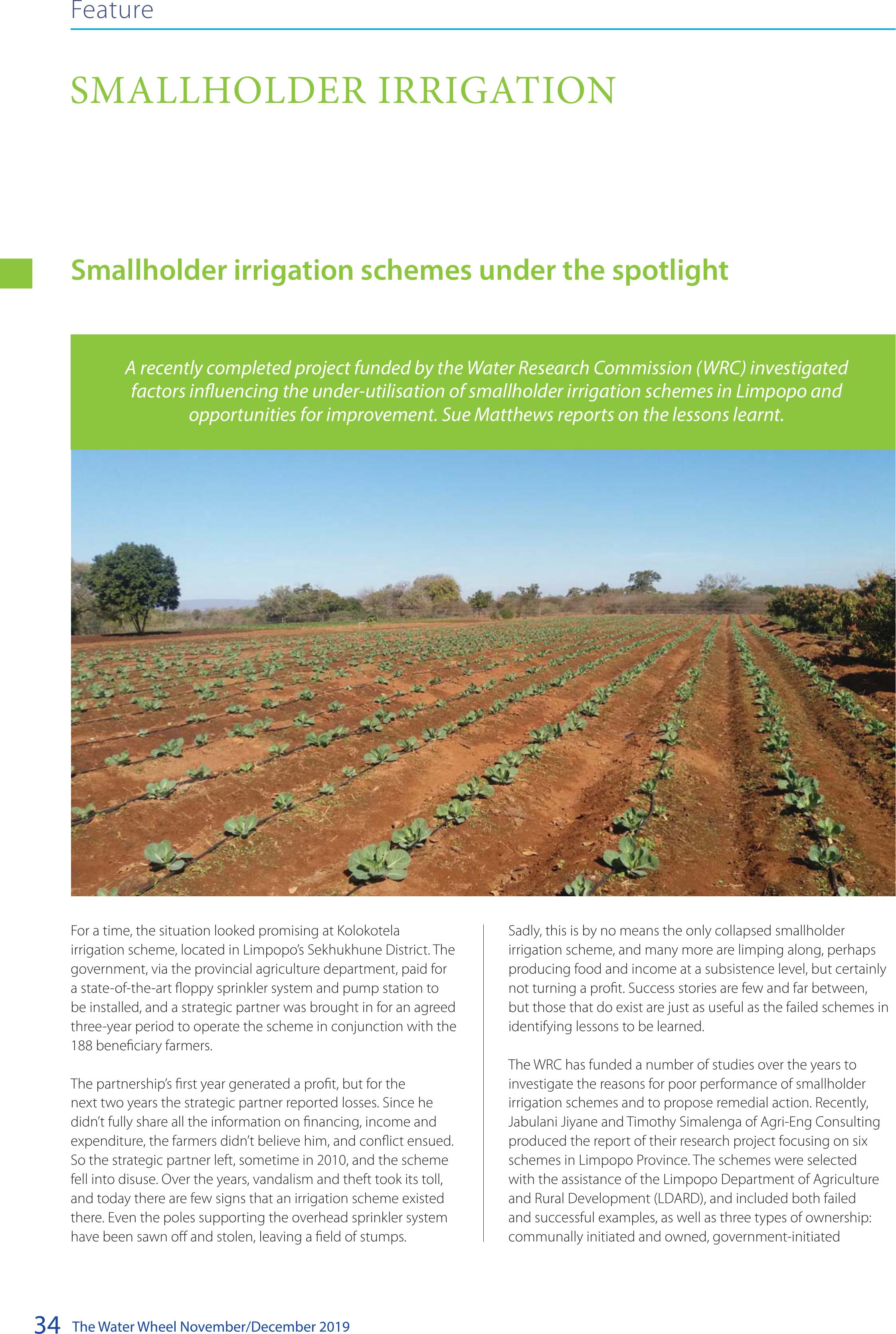
The Water Wheel November/December 2019
34
Feature
SMALLHOLDER IRRIGATION
For a time, the situation looked promising at Kolokotela
irrigation scheme, located in Limpopo’s Sekhukhune District. The
government, via the provincial agriculture department, paid for
a state-of-the-art floppy sprinkler system and pump station to
be installed, and a strategic partner was brought in for an agreed
three-year period to operate the scheme in conjunction with the
188 beneficiary farmers.
The partnership’s first year generated a profit, but for the
next two years the strategic partner reported losses. Since he
didn’t fully share all the information on financing, income and
expenditure, the farmers didn’t believe him, and conflict ensued.
So the strategic partner left, sometime in 2010, and the scheme
fell into disuse. Over the years, vandalism and theft took its toll,
and today there are few signs that an irrigation scheme existed
there. Even the poles supporting the overhead sprinkler system
have been sawn off and stolen, leaving a field of stumps.
Sadly, this is by no means the only collapsed smallholder
irrigation scheme, and many more are limping along, perhaps
producing food and income at a subsistence level, but certainly
not turning a profit. Success stories are few and far between,
but those that do exist are just as useful as the failed schemes in
identifying lessons to be learned.
The WRC has funded a number of studies over the years to
investigate the reasons for poor performance of smallholder
irrigation schemes and to propose remedial action. Recently,
Jabulani Jiyane and Timothy Simalenga of Agri-Eng Consulting
produced the report of their research project focusing on six
schemes in Limpopo Province. The schemes were selected
with the assistance of the Limpopo Department of Agriculture
and Rural Development (LDARD), and included both failed
and successful examples, as well as three types of ownership:
communally initiated and owned, government-initiated
Smallholder irrigation schemes under the spotlight
A recently completed project funded by the Water Research Commission (WRC) investigated
factors inuencing the under-utilisation of smallholder irrigation schemes in Limpopo and
opportunities for improvement. Sue Matthews reports on the lessons learnt.
BACK TOP TOP

The Water Wheel November/December 201935
and communally owned, or privately owned public-private
partnerships.
During October 2018 the project team visited each scheme,
where they conducted an interview with a panel of farmers,
committee members, extension officers and relevant
stakeholders. An assessment template had been developed
to record information on aspects such as beneficiary socio-
economics, crop and soil types, irrigation infrastructure and
management, and markets and finance. After each interview, a
transect walk of the scheme was done to assess pump stations,
balancing dams, infield irrigation and power supply, as well as
the general condition of soils and crops.
The success story in this case was the Mphaila irrigation scheme,
trading as Chime Agricultural Cooperative, in the Vhembe
District. The scheme is demarcated into blocks averaging a
hectare each for the 62 individual household farmers, who make
their own decisions on crop selection, irrigation scheduling and
marketing. The cooperative’s marketing team has established
firm relationships with a number of sales outlets, however,
and crop inputs are purchased in bulk, so the farmers benefit
from discounts. There is an experienced agricultural extension
officer living on site and providing ongoing advice and support,
and formal training has been given in aspects such as agro-
processing, soil and water conservation, nursery management
and chemical safety. The farmers have organised themselves into
study groups, and there is a concerted effort to involve youth to
ensure a succession plan. At the time of the visit, the irrigation
system was in the process of being changed from overhead
sprinklers to drip irrigation.
Taking the successes and failures of all six smallholder irrigation
schemes into account, the project team were able to identify the
key factors contributing to their underutilisation.
Problems posed by cooperative farming
“The study showed that the cooperative concept in smallholder
irrigation farming does not work,” noted the project team.
“The allocation of farms or plots to several people resulted
in conflicts and infighting, causing either the collapse of the
smallholder farming or reduced production levels. This finding is
corroborated by several other studies carried out in South Africa,
Africa and other places.” The project team instead advocated
the ‘one block one household’ approach, and pointed out that
irrigation methods that do not allow for demarcation into
individual blocks, such as the floppy irrigation system, are not
suitable for smallholder irrigation schemes owned by several
beneficiaries.
Lack of skills in irrigation scheduling
All the schemes were found to rely on “crude and inaccurate
methods for determining when to irrigate and how much water
to apply,” noted the project team. This has direct implications
for crop quality and yield. What’s more, a few of the schemes
were making use of furrow irrigation, resulting in water use
inefficiencies and – in some cases – soil erosion.
Problems with the strategic partner approach
The strategic partnership model was introduced to capacitate
and mentor farmers, but its effective implementation requires
an agreement for each scheme specifying how both parties
will participate and benefit. Typically, strategic partners would
provide training, access to markets, as well as inputs and
machinery, in exchange for profit sharing. However, the collapse
of schemes following the departure of strategic partners
indicates that the approach may not be sustainable and warrants
further investigation. “The strategic partnership model as it
stands now has not delivered and has not produced the desired
outcome,” the project team remarked.
Lack of business attitude and record-keeping
The farmers have no proper and detailed records of production
costs, nor their seasonal water use or other input quantities.
They are not aware if they have made a profit, and cannot
demonstrate performance of the farm or irrigation scheme. “As
long as farmers do not have an income/ expenditure attitude
towards irrigated agricultural production, the level of production
at the smallholder schemes will be low,” noted the project team.
No prior arrangement of markets
The farmers cultivate the crops and only look for markets at
the point of harvest. “This leads to produce fetching low prices,
or failure to find a market in time, resulting in produce getting
spoiled.”
Vandalism and theft
Three of the schemes had experienced serious problems related
to vandalism and theft of irrigation assets, which according to
the project team could “be attributed to overall management
problems and lack of accountability in leadership.”
The project team proposed a number of interventions for
improved performance of smallholder irrigation schemes in
Limpopo province – and South Africa in general – including
the adoption of the ‘one block one household’ approach and a
comprehensive review of the strategic partnership model. They
recommended that smallholder farmers be given training in
basic business management, marketing and record-keeping,
with a view to transforming them into entrepreneurs and
business people. Likewise, easy and affordable irrigation
scheduling methods should be introduced at the schemes, and
training provided.
They noted too that there might be a need to investigate the
operational costs, design and profitability of floppy irrigation
systems – at the Mbahela irrigation scheme, for example, the
Smallholder irrigation
On many smallholder irrigation schemes, existing irrigation
infrastructure is in dire need of maintenance.
Lani van Vuuren
BACK TOP TOP
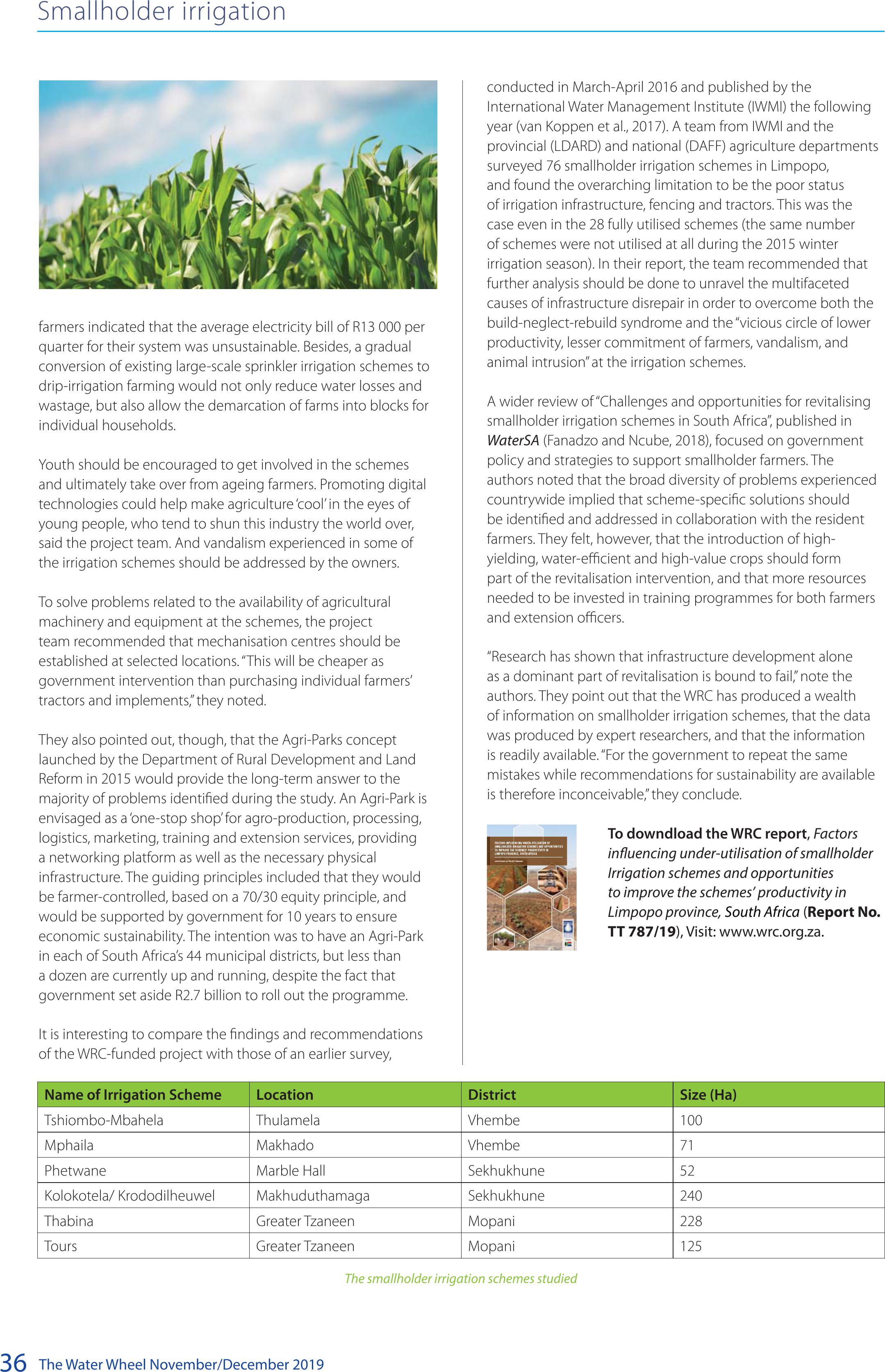
The Water Wheel November/December 2019
36
conducted in March-April 2016 and published by the
International Water Management Institute (IWMI) the following
year (van Koppen et al., 2017). A team from IWMI and the
provincial (LDARD) and national (DAFF) agriculture departments
surveyed 76 smallholder irrigation schemes in Limpopo,
and found the overarching limitation to be the poor status
of irrigation infrastructure, fencing and tractors. This was the
case even in the 28 fully utilised schemes (the same number
of schemes were not utilised at all during the 2015 winter
irrigation season). In their report, the team recommended that
further analysis should be done to unravel the multifaceted
causes of infrastructure disrepair in order to overcome both the
build-neglect-rebuild syndrome and the “vicious circle of lower
productivity, lesser commitment of farmers, vandalism, and
animal intrusion” at the irrigation schemes.
A wider review of “Challenges and opportunities for revitalising
smallholder irrigation schemes in South Africa”, published in
WaterSA (Fanadzo and Ncube, 2018), focused on government
policy and strategies to support smallholder farmers. The
authors noted that the broad diversity of problems experienced
countrywide implied that scheme-specific solutions should
be identified and addressed in collaboration with the resident
farmers. They felt, however, that the introduction of high-
yielding, water-efficient and high-value crops should form
part of the revitalisation intervention, and that more resources
needed to be invested in training programmes for both farmers
and extension officers.
“Research has shown that infrastructure development alone
as a dominant part of revitalisation is bound to fail,” note the
authors. They point out that the WRC has produced a wealth
of information on smallholder irrigation schemes, that the data
was produced by expert researchers, and that the information
is readily available. “For the government to repeat the same
mistakes while recommendations for sustainability are available
is therefore inconceivable,” they conclude.
To downdload the WRC report, Factors
inuencing under-utilisation of smallholder
Irrigation schemes and opportunities
to improve the schemes’ productivity in
Limpopo province,South Africa (Report No.
TT 787/19), Visit: www.wrc.org.za.
farmers indicated that the average electricity bill of R13 000 per
quarter for their system was unsustainable. Besides, a gradual
conversion of existing large-scale sprinkler irrigation schemes to
drip-irrigation farming would not only reduce water losses and
wastage, but also allow the demarcation of farms into blocks for
individual households.
Youth should be encouraged to get involved in the schemes
and ultimately take over from ageing farmers. Promoting digital
technologies could help make agriculture ‘cool’ in the eyes of
young people, who tend to shun this industry the world over,
said the project team. And vandalism experienced in some of
the irrigation schemes should be addressed by the owners.
To solve problems related to the availability of agricultural
machinery and equipment at the schemes, the project
team recommended that mechanisation centres should be
established at selected locations. “This will be cheaper as
government intervention than purchasing individual farmers’
tractors and implements,” they noted.
They also pointed out, though, that the Agri-Parks concept
launched by the Department of Rural Development and Land
Reform in 2015 would provide the long-term answer to the
majority of problems identified during the study. An Agri-Park is
envisaged as a ‘one-stop shop’ for agro-production, processing,
logistics, marketing, training and extension services, providing
a networking platform as well as the necessary physical
infrastructure. The guiding principles included that they would
be farmer-controlled, based on a 70/30 equity principle, and
would be supported by government for 10 years to ensure
economic sustainability. The intention was to have an Agri-Park
in each of South Africa’s 44 municipal districts, but less than
a dozen are currently up and running, despite the fact that
government set aside R2.7 billion to roll out the programme.
It is interesting to compare the findings and recommendations
of the WRC-funded project with those of an earlier survey,
Smallholder irrigation
Name of Irrigation SchemeLocationDistrictSize (Ha)
Tshiombo-Mbahela ThulamelaVhembe100
MphailaMakhado Vhembe71
PhetwaneMarble HallSekhukhune52
Kolokotela/ Krododilheuwel MakhuduthamagaSekhukhune240
ThabinaGreater TzaneenMopani228
ToursGreater TzaneenMopani125
The smallholder irrigation schemes studied
BACK TOP TOP

The Water Wheel November/December 201937
Creating climate change resilient communities Part 2: Impact of
climate resilience practices on rural livelihoods
The project is exploring best practice options for climate resilient
agriculture for smallholders and evaluating the impact of
implementation of a range of these practices on the resilience
of agriculture-based livelihoods. Alongside this, a decision
support methodology and system has been designed to assist
smallholders and the facilitators who support them to make
informed and appropriate decisions about choices of a ‘basket of
options’ for implementation at a local level.
Climate resilient agriculture (CRA) practices for
smallholders
The approach is to work directly with smallholders in local
contexts to improve practices and synergise across sectors.
The emphasis is thus at farm/household level. Here, CRA aims
to improve aspects of crop production, livestock and pasture
management, natural resource management, as well as soil and
water management as depicted in Figure 1.
Figure 1: Household level implementation of CSA integrates across
sectors (adapted from Arslan, 2014)
In this second article based on the Water Research Commission (WRC) funded project titled
‘Collaborative knowledge creation and mediation strategies for the dissemination of water and
soil conservation practices and climate smart agriculture in smallholder systems’ we look at
climate resilient agricultural practices and the impact of implementation of these practices on
rural livelihoods. Article by Erna Kruger.
CLIMATE CHANGE
Feature
BACK TOP TOP

The Water Wheel November/December 2019
38
A database of 66 different practices falling into the categories mentioned in the figure above has been compiled, based on local
suggestions and best bet options from experience and literature. A selection of the practices is shown in the table below. Farmers decide
on practices to try out and implement depending on their own situations and preferences as well as suggestions made by the facilitation
team.
GardeningField cropping (Conservation Agriculture)Livestock management
Intensive gardening techniques: including
trench beds, mulching, liquid manure,
mixed cropping, planting of nutritional
herbs and multifunctional plants, fruit
production, seed saving
Diversification of cropping: including
legumes and cover crops (sunflower, millet,
sunn hemp, black oats, fodder rye and
fodder radish)
Fodder production and management for
livestock
Soil and water conservation techniques:
including swales, furrows and ridges, stone
bunds, check dams
Intercropping and crop rotation; strip
cropping options and spacing
Local feed production options
Tunnels; Shade cloth structures for
microclimate control
No till plantersChicken tractors
Rainwater harvesting; in field methods and
storage options, small dams
Mulching, manure and organic optionsWinter supplementation
Climate change
consisting of production in trench beds, inside and outside
of shade cloth tunnels was conducted. The control for this
experiment was the farmer’s ‘normal’ gardening practice – in this
case raised beds.
Farmers kept careful records of the amount of water applied
(irrigation) and their harvests (yields), alongside the research
team who worked with local weather stations and soil moisture
measurements to assess the water productivity of these
practices.
The table below outlines the resultant water productivity
calculation for this experiment. Both conventional water
productivity calculations and a simpler format suggested by
farmers that only uses their water applied were used.
For each practice, a 1-page summary has been put together,
that can be presented to smallholders in the climate change
adaptation workshops, for consideration by the smallholder
farmers as a new idea or innovation to experiment with.
This database provides a resource to farmers and facilitators to
choose appropriate climate resilient agricultural practices for
their area and their particular situation. It is one of the input
parameters for the decision support process.
In addition, qualitative and quantitative indicators have been
explored to physically assess the impact of these practices. These
have included for example run-off, infiltration, water holding
capacity in the soil profile, and water productivity as well as
a number of soil- based parameters such as organic matter
content, soil fertility and microbial activity.
As an example, a farmer level experimentation process
Table 1: a summary of a selection of CRA practices considered and implemented by smallholder farmers
Table 2: Water productivity for production of spinach inside and outside shade cloth tunnels for 2 smallholder farmers in KNV, Bergville
Bgvl June-Sept 2018Simple scientic method (ET)Farmers’ method (Water applied)
Name of famer water use (m3)Total weight (kg)WP (kg/m3)water use (m3)Total weight (kg)WP (kg/m3)
Phumelele Hlongwane
trench bed inside tunnel
1,6521,0612,76 1,8521,0611,38
Phumelele Hlongwane;
trench bed outside tunnel
0,835,326,45 1,755,323,04
Ntombakhe Zikode trench
bed inside tunnel
1,6517,7110,73 2,3717,717,47
Ntombakhe Zikode; trench
bed outside tunnel
0,503,356,76 0,533,356,33
The control plots are not included here, as the two farmers realised quite early in the season that their normal production methods
required too much water and opted to focus only on the trench beds. Water productivity is 60-100% higher for trench beds inside
the tunnels when compared to trench beds outside the tunnel – using the more scientific approach that also takes into account
evapotranspiration and leaching. This is a highly significant result, indicating the potential of micro-climate control in adaptation.
Water productivity calculate only from yields compared to water applied, shows a larger variation in results for the two participants. They
both applied more water to their trench beds outside their tunnels, than inside; working on the assumption that the reduced growth
BACK TOP TOP

The Water Wheel November/December 201939
criteria. Community members work in small groups to analyse
for themselves the impact of the climate resilient agricultural
practices they have been implementing.
Below is the result of a matrix ranking exercise conducted during
this session. The research team were incredibly impressed with
the depth of analysis participants undertook and with the
impact indicators participants developed. It also indicates that
smallholder farmers use integrated and systemic indicators to
make their decisions and not just production and income data,
commonly used in agriculture.
for the crops outside the tunnel was due to water stress. This
experimentation process assisted in their learning that plant
stress also includes other factors such as temperature, wind and
insect damage.
Participatory impact assessments
After a cycle of experimentation with the basket of CRA
practices (one season/ 6 months), the process is reviewed and
a participatory impact assessment process is conducted with
the learning group members. It is important for community
members themselves to develop the impact indicators/
Climate change
IMPACT
INDICATORS
PRACTICES
Soil;
health
and
fertility
Money;
income
and
savings
Productivity;
acceptance of
practice, saving
in farming –
equipment,
labour
Knowledge;
increased
knowledge
and ability
to use
Food; how
much
produced
and how
healthy
Water; use
and access
Social agency;
Support,
empowerment
Total
Conservation
Agriculture
2221 2628182318156
Savings 6151415 12111588
Livestock 1911 1875121183
Gardening 1415 1213151721107
Crop rotation1612 131212151090
Intercropping 1213 15121111983
Small businesses1117 15102011993
Table 3: Particiatory impact assessment of CRA practices by KZN participants, March 2019.
The resilience snapshot put together from individual interviews for these same participants, gives a very strong indication of the benefit
of CRA to the livelihoods of the rural poor. Climate change adaptation for these participants has resulted in increased availability of food,
incomes and social agency and has provided hope for a more positive future for these participants.
Table 4: Resilience snapshot for KZN participants, March 2019.
A farmer level innovation approach to implementation of CRA practices in smallholder farming systems provides a powerful tool for
community-based climate change adaptation and improvement of rural livelihoods.
Positive impact of CRA and associated practices in order of importance: Conservation Agriculture, gardening (tunnels, agroecology),
small businesses (farmer centres, poultry), savings, livestock (integration – fodder, health)
Left to right: Spinach grown in a trench bed inside a tunnel, in a trench bed outside a tunnel and in a control bed (raised bed).
BACK TOP TOP

The Water Wheel November/December 2019
40
Feature
AGRICULTURE AND POLLUTION
The first genetically modified (GM) maize crops were planted in
South Africa more than 20 years ago amid industry promises of
higher crop yields and a widespread reduction in toxic pesticide
use.
Since then, however, the use of certain pesticides has risen
dramatically among commercial farmers – partly due to the
introduction of GM maize strains that tolerate high doses of
pesticides and because of evolving natural resistance by several
insect pests which has led to the use of larger volumes of
pesticides or the use of more toxic chemical formulations.
Ground-breaking research published in the South African
Journal of Science now suggests that potentially harmful levels
of some of these herbicides are finding their way into country’s
already threatened aquatic environment. In a water-scarce
country such as South Africa, chemical-contamination is of
particular concern for rural families who still rely on untreated
surface and groundwater resources.
Dr Suranie Horn and Prof Rialet Peters (Unit for Environmental
Sciences and Management at North-West University,
Potchefstroom) and Thomas Bøhn (Institute of Marine Research,
Tromsø, Norway) say their study has highlighted the need for
more regular and widespread monitoring of farm chemicals in
the country’s rivers, dams and other water courses.
Most significantly, the study found that concentrations of
Toxic farm chemicals: Emerging threat to South Africa’s surface
waters
Scientists have raised concerns after nding high levels of toxic farm chemicals in local rivers
and dams close to where genetically-modied (GM) maize crops are grown.
Article by Tony Carnie.
The use of certain farm chemicals has risen dramatically among commercial farmers, partly due to the introduction of genetically modified maize strains
that tolerate high doses of pesticides.
All photographs courtesy NWU
BACK TOP TOP
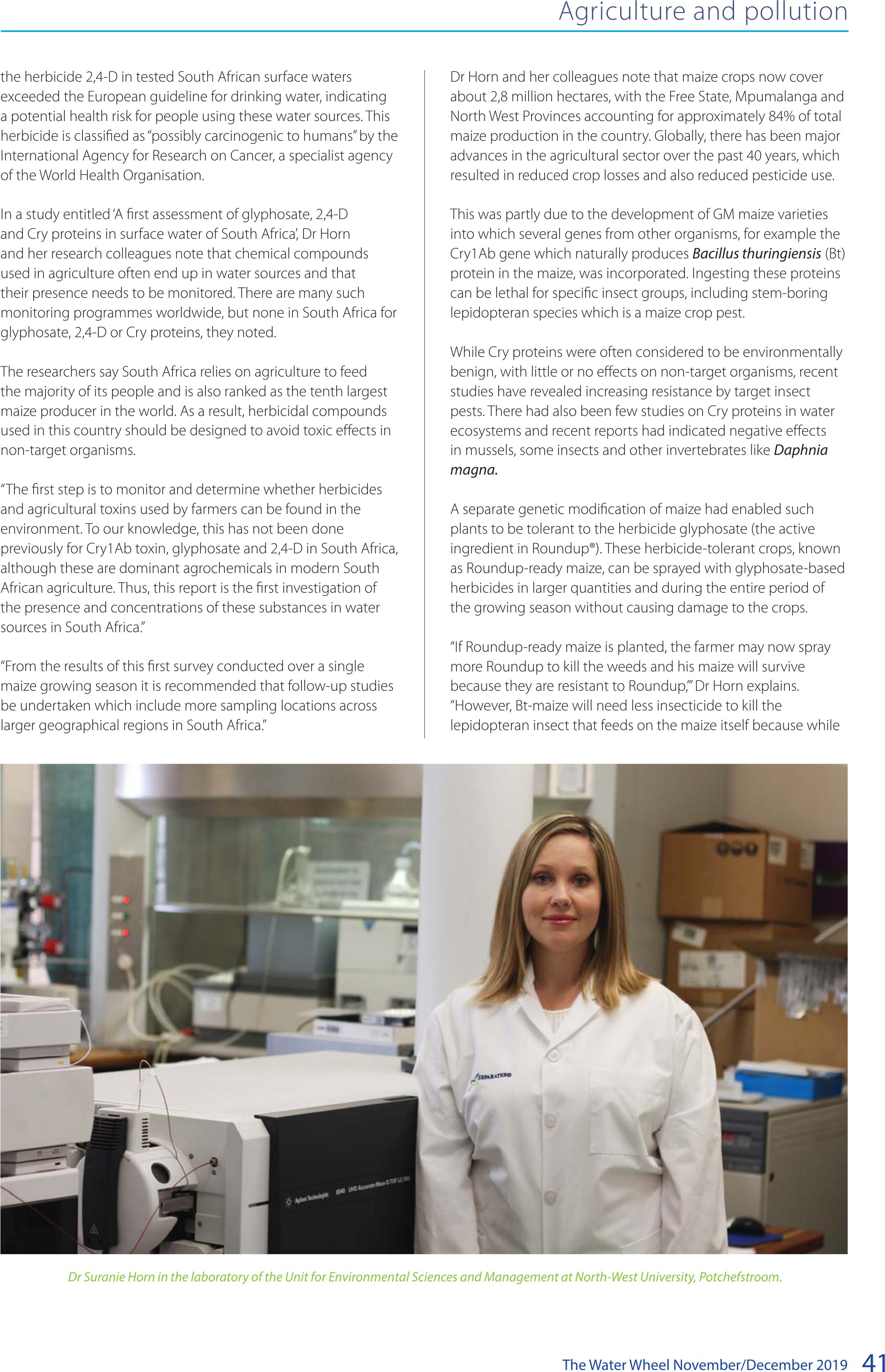
The Water Wheel November/December 201941
the herbicide 2,4-D in tested South African surface waters
exceeded the European guideline for drinking water, indicating
a potential health risk for people using these water sources. This
herbicide is classified as “possibly carcinogenic to humans” by the
International Agency for Research on Cancer, a specialist agency
of the World Health Organisation.
In a study entitled ‘A first assessment of glyphosate, 2,4-D
and Cry proteins in surface water of South Africa’, Dr Horn
and her research colleagues note that chemical compounds
used in agriculture often end up in water sources and that
their presence needs to be monitored. There are many such
monitoring programmes worldwide, but none in South Africa for
glyphosate, 2,4-D or Cry proteins, they noted.
The researchers say South Africa relies on agriculture to feed
the majority of its people and is also ranked as the tenth largest
maize producer in the world. As a result, herbicidal compounds
used in this country should be designed to avoid toxic effects in
non-target organisms.
“The first step is to monitor and determine whether herbicides
and agricultural toxins used by farmers can be found in the
environment. To our knowledge, this has not been done
previously for Cry1Ab toxin, glyphosate and 2,4-D in South Africa,
although these are dominant agrochemicals in modern South
African agriculture. Thus, this report is the first investigation of
the presence and concentrations of these substances in water
sources in South Africa.”
“From the results of this first survey conducted over a single
maize growing season it is recommended that follow-up studies
be undertaken which include more sampling locations across
larger geographical regions in South Africa.”
Dr Horn and her colleagues note that maize crops now cover
about 2,8 million hectares, with the Free State, Mpumalanga and
North West Provinces accounting for approximately 84% of total
maize production in the country. Globally, there has been major
advances in the agricultural sector over the past 40 years, which
resulted in reduced crop losses and also reduced pesticide use.
This was partly due to the development of GM maize varieties
into which several genes from other organisms, for example the
Cry1Ab gene which naturally produces Bacillus thuringiensis (Bt)
protein in the maize, was incorporated. Ingesting these proteins
can be lethal for specific insect groups, including stem-boring
lepidopteran species which is a maize crop pest.
While Cry proteins were often considered to be environmentally
benign, with little or no effects on non-target organisms, recent
studies have revealed increasing resistance by target insect
pests. There had also been few studies on Cry proteins in water
ecosystems and recent reports had indicated negative effects
in mussels, some insects and other invertebrates like Daphnia
magna.
A separate genetic modification of maize had enabled such
plants to be tolerant to the herbicide glyphosate (the active
ingredient in Roundup®). These herbicide-tolerant crops, known
as Roundup-ready maize, can be sprayed with glyphosate-based
herbicides in larger quantities and during the entire period of
the growing season without causing damage to the crops.
“If Roundup-ready maize is planted, the farmer may now spray
more Roundup to kill the weeds and his maize will survive
because they are resistant to Roundup,’” Dr Horn explains.
“However, Bt-maize will need less insecticide to kill the
lepidopteran insect that feeds on the maize itself because while
Agriculture and pollution
Dr Suranie Horn in the laboratory of the Unit for Environmental Sciences and Management at North-West University, Potchefstroom.
BACK TOP TOP

The Water Wheel November/December 2019
42
Agriculture and pollution
ingesting the maize plant the stem-borer also ingests the Cry
protein that kills it. So, with Bt-maize, the farmer does not need
to spray an insecticide.”
Dr Horn’s report notes that glyphosate was now the most widely
used herbicide in the world although it has also been classified
a probable human carcinogen by the International Agency
for Research on Cancer, but not by the European Food Safety
Authority. However, because several weed species had become
resistant to this pesticide, some farmers were now using more
toxic herbicides, such as 2,4-D.
Dr Horn and her colleagues report that South Africa is the
biggest user of pesticides in sub-Saharan Africa, using more than
500 registered active chemical ingredients. “The use of herbicides
on GM maize – of which 80% is the Roundup-ready version – has
increased drastically over past years, and further increases are
expected to occur in the next few years.”
Generally, pesticides were developed to target specific pests and
to be immobile. However, because of run-off, leaching and spray
drift these compounds were spread into unintended sections of
the environment, including water sources.
“These compounds generally occur at low concentrations, and it
is assumed that they would not have detrimental effects on non-
target organisms. However, exposure to low levels of pesticides
poses a chronic risk to human health, including endocrine
disruption, immune impacts, neurotoxicity, genotoxicity,
carcinogenesis and mutagenicity.”
The latest research by Dr Horn and colleagues involved sampling
rivers and dams on two farms in the Free State, where Bt and
Roundup-ready maize is grown and sprayed with Roundup and
2.4-D. Analysis showed that there were no detectable levels of
Cry1Ab proteins in any of the water samples collected near the
Free State farms – in contrast to tests in the United States corn
belt, where these proteins were detected in 23% of 215 water
samples.
With glyphosate, the levels were mostly below the limit of
detection at most of the sites – also in contrast to tests in other
countries such as Spain, where quantifiable levels were found
in 41% of samples. However, almost all the water samples
collected in the Free State contained measurable levels of 2,4-D
(with a minimum of 0.72 μg/L and a maximum of 1.08 μg/L).
The highest concentration was detected after spraying and
decreased towards the end of the season.
These levels were higher than samples collected in Mexico, but
lower than those collected in the United States.
While they were all below the maximum residue limit for
pesticides in drinking water in both Canada and the USA – most
of the Free State levels were an order of magnitude higher than
the EU drinking water limit of 0.1 μg/L, and this could result in
possible effects on human health.
For example, a Canadian study found a significantly increased
risk of cancer (non-Hodgkin’s disease) in men exposed to 2,4-D,
while other studies reported that 2,4-D could reduce growth
rates, induce reproductive problems, and produce changes in
appearance or behaviour, or could cause death of non-target
species, including plants, animals and microorganisms.
In contrast, other studies which examined the systemic toxicity,
developmental neurotoxicity, developmental immunotoxicity,
reproductive toxicity, endocrine modulation and thyroid
effects in humans, had found that 2,4-D was unlikely to pose a
significant health risk.
The water sampling sites where pesticides were collected near maize farms along the Free State and North West provincial border.
BACK TOP TOP

The Water Wheel November/December 201943
Nevertheless, Dr Horn and colleagues suggest that while
the debate on the safety of herbicides continued, there may
be unknown long-term effects on human health and the
environment.
Overall, the researchers did not find Cry1Ab proteins at
quantifiable levels and only one sample contained glyphosate.
But 2,4-D was present at quantifiable levels in more than 70%
of the samples and all of these concentrations exceeded the EU
general guideline for drinking water.
“Recently, research has revealed adverse health effects of Cry1Ab,
glyphosate and 2,4-D exposure to non-target organisms. These
effects could also influence biodiversity; therefore, water sources
should be monitored to ensure both healthy aquatic ecosystems
as well as safe drinking water.”
Asked to comment on why there appeared to have been little
South African-based research on this subject previously, Dr Horn
said: “A lot of research has been going on with GM maize and
potential effects on non-target organisms, but it is not usually
published in South African public domain journals. We could not
find any publications with the levels of these three compounds
for South Africa.”
“Analysing for any of them is also expensive, whether using
ELISA kits or via instrumental analysis. There is no laboratory
that analyses for glyphosate or 2,4-D in this country, that we are
aware of (at least not when we sampled in 2015). Cry analysis is
also not done in SA on a wide scale. We are one of the only two
labs that can do so for Cry1Ab specifically and we did it with
ELISAs, not with an analytical instrument.”
The researchers said they would like to analyse more rivers and
water sources around South Africa, but are in need of further
funding to continue this research.
Agriculture and pollution
A study by Dr Suranie Horn and Prof Rialet Peters from North-West
University, Potchefstroom and Thomas Bøhn from the Institute of Marine
Research in Norway has highlighted the need for more regular and
widespread monitoring of farm chemicals in the country’s rivers, dams
and other water courses.
Concentrations of 2,4-D found across all sites, showing exceedances of the EU general drinking water guideline (0.1 μg/L).
BACK TOP TOP

The Water Wheel November/December 2019
44
Water Kidz
Sure, we need water to drink, but have you thought about using
water to create energy? Moving water has a lot of energy and all
we need to do is to harness it.
One of the most successful means of harnessing water power is
through the use of water wheels. A water wheel can basically be
described as a device that uses flowing or falling water to create
power by means of a set of paddles or buckets mounted around
a wheel. The force of the water moves the paddles, and the
consequent rotation of the wheel is transmitted to machinery via
a shaft of the wheel. In this way the energy of the falling water is
converted into useful forms of power.
Water wheels can either be horizontal or vertical (although the
latter is most common). Early water wheels were manufactured
from wood and other natural materials, such as bamboo. Later
water wheels were manufactured from metal.
Water wheels require a nearby source of flowing or falling water.
These sources could include streams or small rivers. Occasionally,
special ponds (called mill ponds) would be built by damming a
flowing stream. A special channel – called a mill race – would be
created from the pond to the water wheel, so that flowing water
could be accessed any time the water wheel was needed.
No-one knows exactly when or by whom the water wheel was
originally invented. References to water wheels can be found
in literature thousands of years old. All the ancient civilisations
made use of water wheels – albeit of different designs, from
the Chinese to the Greeks (and later the Romans), to ancient
Middle Eastern civilisations. Water wheels were probably the first
method of creating mechanical energy that replaced humans
and animals. A mill could replace the power of ten to twenty
people, producing on average two to three horsepower.
It was during the early Industrial Revolution that water wheels
really came into their own. From monasteries to commercial
factories, water wheels were used for everything from grinding
flour, to hammering wrought iron, machining, ore crushing,
crushing sugarcane, and pounding fibre for use in the
:DWHU Water wheels
An ancient water
mill in Spain.
Harnessing nature’s
power
BACK TOP TOP

The Water Wheel November/December 201945
Water Kidz
manufacture of cloth. By the end of the eleventh century there
were an estimated 5 600 mills in England alone!
In places such as Europe old water wheels can still be found,
although they are now mostly used as tourist attractions.
The hydraulic turbine is a modern invention based on the same
principles as the water wheel. It is a rotary engine that uses
the flow of fluid, either gas or liquid, to turn a shaft that drives
machinery. Hydraulic turbines are used in hydroelectric power
stations. Flowing or falling water strikes a series of blades or
buckets attached around a shaft. The shaft then rotates and the
motion drives the rotor of an electric generator.
Water wheels in South Africa
Water wheels can also be found in South Africa. Perhaps the
most famous are the water wheels found in the Northern Cape
towns of Kakamas and Keimoes. Unlike Europe, these water
wheels were not used so much in industry but rather to lift
irrigation water from lower to higher irrigation fields.
The design of the South African water wheel is based on that of
the noria, a water wheel which probably originated in Persia and
that is basically a wheel fitted with buckets on the peripherals for
lifting water (for this reason people used to refer to these water
wheel as ‘bakkiespompe’).
Sources
• https://wiki.kidzsearch.com/wiki/Water_wheel
• https://www.thoughtco.com/history-of-
waterwheel-4077881
• https://www.forteachersforstudents.com.au/site/
themed-curriculum/water-wheels/facts/
Making a water wheel
Want to make your own water wheel? Watch the
instructions here:
https://www.wikihow.com/Make-a-Water-Wheel
This example of an overshot water wheel can be found in Derbyshire,
England.
– A close up of the old restored water wheels at Kakamas.
The old water wheels at Kakamas contain small buckets that move water
between irrigation canals.
Lani van Vuuren
BACK TOP TOP
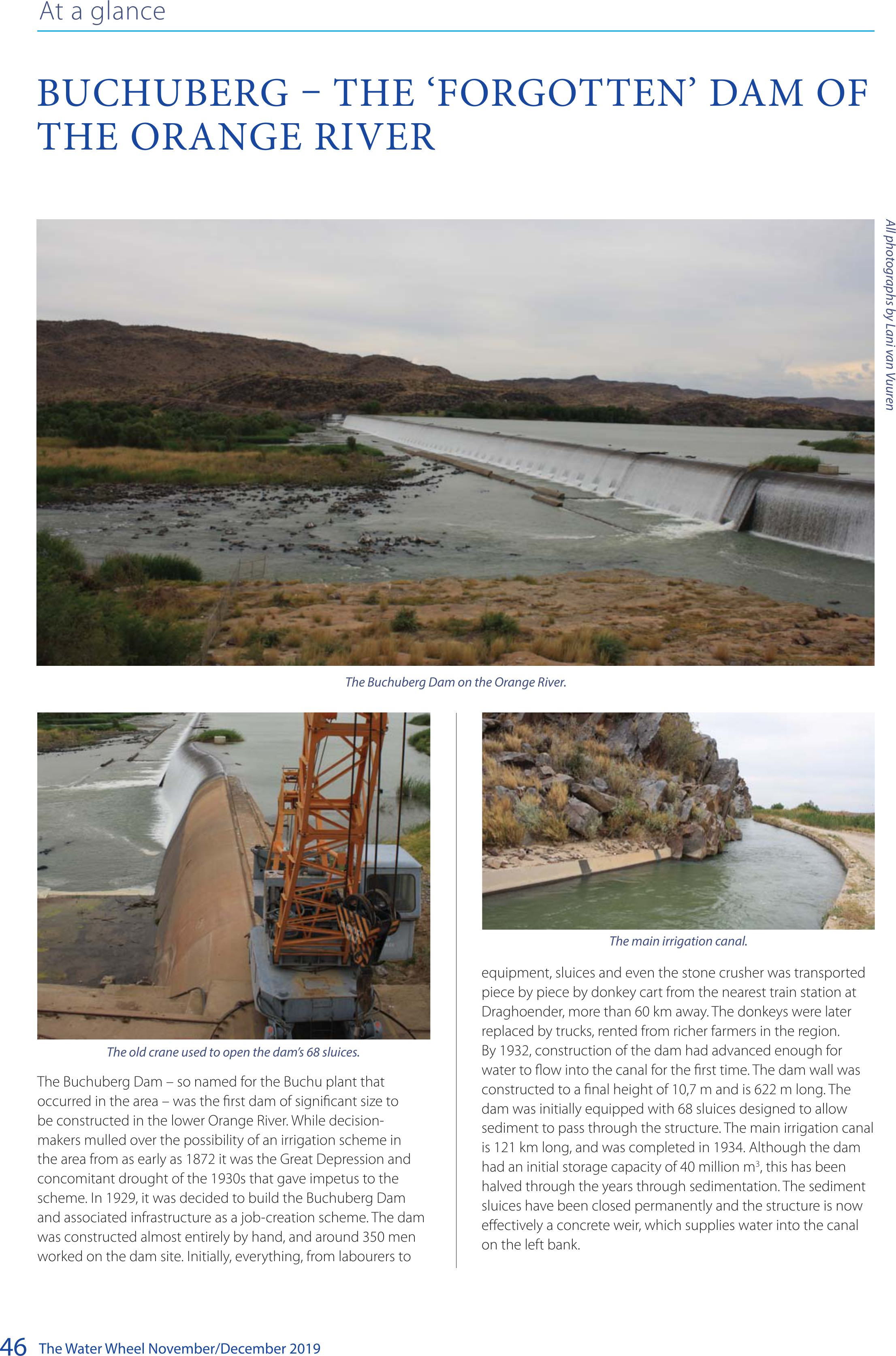
The Water Wheel November/December 2019
46
At a glance
BUCHUBERG – THE ‘FORGOTTEN’ DAM OF
THE ORANGE RIVER
The Buchuberg Dam – so named for the Buchu plant that
occurred in the area – was the first dam of significant size to
be constructed in the lower Orange River. While decision-
makers mulled over the possibility of an irrigation scheme in
the area from as early as 1872 it was the Great Depression and
concomitant drought of the 1930s that gave impetus to the
scheme. In 1929, it was decided to build the Buchuberg Dam
and associated infrastructure as a job-creation scheme. The dam
was constructed almost entirely by hand, and around 350 men
worked on the dam site. Initially, everything, from labourers to
All photographs by Lani van Vuuren
The Buchuberg Dam on the Orange River.
The main irrigation canal.
equipment, sluices and even the stone crusher was transported
piece by piece by donkey cart from the nearest train station at
Draghoender, more than 60 km away. The donkeys were later
replaced by trucks, rented from richer farmers in the region.
By 1932, construction of the dam had advanced enough for
water to flow into the canal for the first time. The dam wall was
constructed to a final height of 10,7 m and is 622 m long. The
dam was initially equipped with 68 sluices designed to allow
sediment to pass through the structure. The main irrigation canal
is 121 km long, and was completed in 1934. Although the dam
had an initial storage capacity of 40 million m3, this has been
halved through the years through sedimentation. The sediment
sluices have been closed permanently and the structure is now
effectively a concrete weir, which supplies water into the canal
on the left bank.
The old crane used to open the dam’s 68 sluices.
BACK TOP TOP

The Water Wheel May/June 2016
48
Upfront